

96blizz
-
Posts
2,530 -
Joined
-
Last visited
Content Type
Profiles
Blogs
Forums
American Weather
Media Demo
Store
Gallery
Posts posted by 96blizz
-
-
1 minute ago, PerintonMan said:
Yeah this is kind of what I'm saying. The jackpot zone isn't going to be BUF-SYR (though the whole region will cash in pretty well). It's going to be just north of the mix line.
For sure that razor thin line will have maximas - but not far to the North and West of that - ratios will be a bit better - likely making things a bit more uniform than it looks.
-
 2
2
-
-
Just now, TugHillMatt said:
Good flakes size now and snow is laying...even on paved surfaces....our time has finally come!
Is...is...is...is this a positive post?!?!?!?!?
-
1
-
 2
2
-
-
Starting to pick up in Skan now. Getting closer to game time.
-
1 minute ago, Syrmax said:
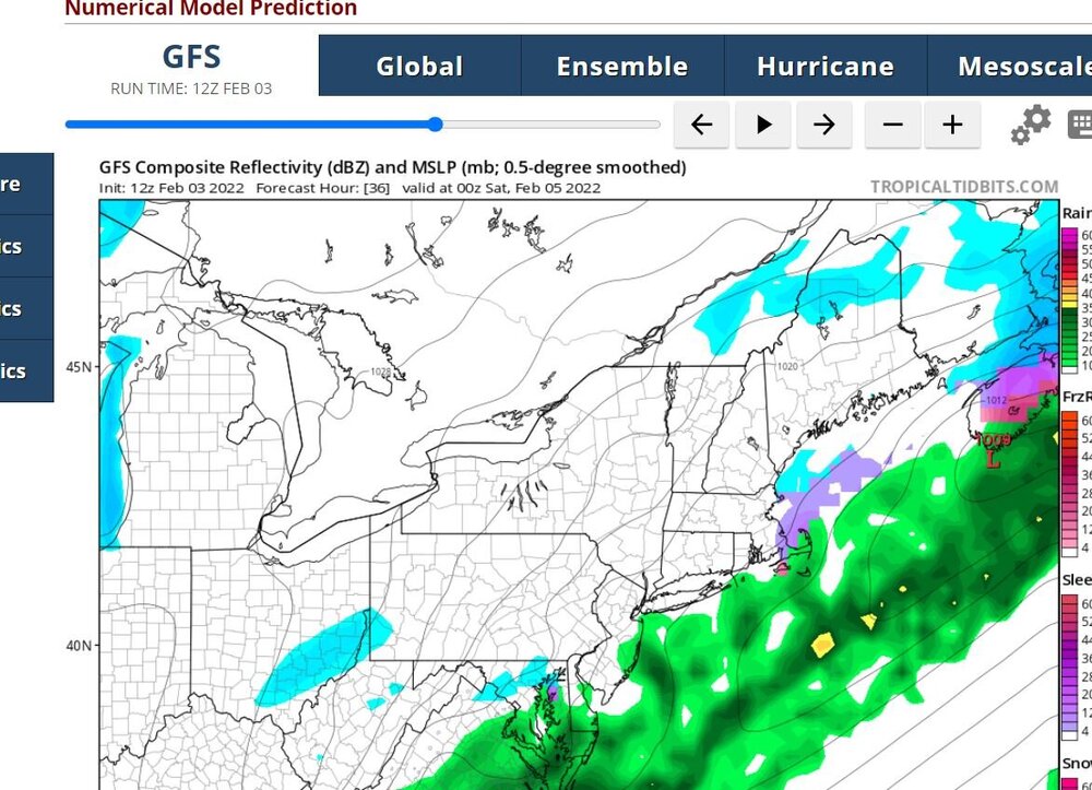
HRRR Bullish...this is out at end of its run, 18 hrs.


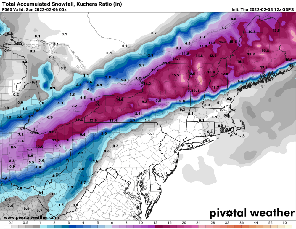
What's with the 10:1 nonsense? Kuchera that dawg up!
-
 3
3
-
-
7 minutes ago, Syrmax said:
This seems rambunctious for snowfall but I like the totals out at the edge near Rochester, LOL!

Peter Hall is such a weenie. Great guy - love it!!
-
1
-
-
Syracuse weenies unite!

-
1
-
1
-
-
This is something you don’t see often!

-
I Love Canada!!!
-
1
-
-
Just now, TugHillMatt said:
Yup. The Northern Finger Lakes region is a blackhole when it comes to synoptics.
Makes sense if you look at the finger lakes. Elevation drop from South to North is dramatic. Will take some good rates to overcome that. It’s coming.
")
-
-
2 minutes ago, TugHillMatt said:
That's because we either doubt it's going to happen or it's just a part of our lifestyle to have enough things stocked up... we also know how well they take care of the roads and that we won't be trapped in our homes for long.
")
Exactly this. I come from NJ and feel the same. We just shrug our shoulders and maybe grab some extra junk food for fun.
That and there a LOT less people. Thank God.
-
1
-
-
3 minutes ago, sferic said:
Where do you see that , it's out of here by 00z Saturday, no?
Depending on your drop down you won't see light lake enhanced snows.

-
1
-
-
One more WEENIE MAP! Hey yo Vermont!

-
1
-
-
Latest GFS snows all day tomorrow into the night.
-
1
-
-
No model has much at all here till later today. Here's the most recent HRRR for 4 hours from start.

-
2
-
-
Here comes the lull for many of us. This is where the layperson starts to laugh at Meteorologists and then gets stuck this evening.
-
1
-
-
Just now, LakeEffectKing said:
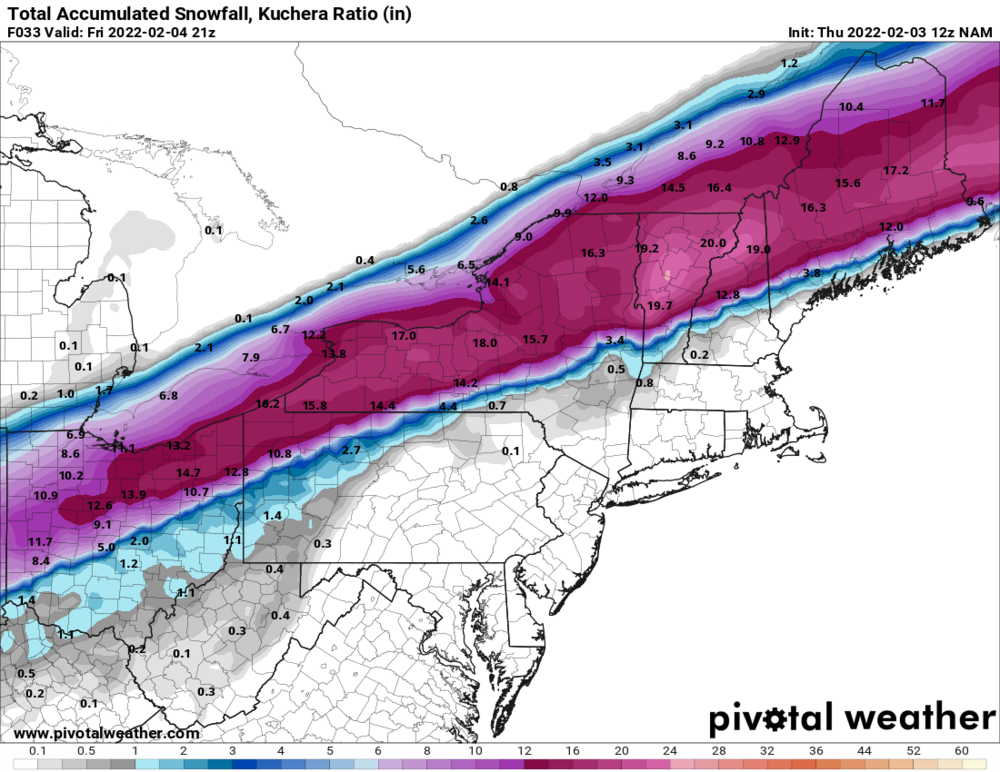
The 12Z NAM is really lingering the snow through Friday afternoon for central New York.
Lovely. LET’S GO!!!!
-
3
-
-
The NAM will probably spit 15” for some at 10:1.
-
3 minutes ago, LakeEffectKing said:
Relative to lead times, all the models did fairly well.. They all wavered a bit but at times showed the general idea. Over the last day and a 1/2 the euro seemed pretty steady. But then again, verification hasn't happened yet, lol!
GFS struggled the most for S and E of here. Wasn’t all bad here - but got a lot of hopes up closer to the major cities.
-
This NAM run is so awesome. I live for this.
-
3
-
-
The schools here could be in a bit of a quagmire. They just left but it could get hairy later…
-
Just now, rochesterdave said:
Got to hand it to the models on this one. Really locked in several days ago and didn’t change to much. Which performed the best (so far)?
Remarkably the GGEM and NAM IMO. They never bit on anything SE and were consistent with the big time second wave.
-
1
-
-
I know it’s too late for models but the NAM looks exquisite. I’m so pumped.
-
2
-
-
Starting to get better flakes here. The NAM also is looking a bit more robust with the first wave.


Feb 2-4th Snowstorm- Observation Thread
in Upstate New York/Pennsylvania
Posted
The only redeeming quality of us ramming that point home was they were ALL at the same time - meaning we are really ridiclous.