

John1122
-
Posts
10,739 -
Joined
-
Last visited
Content Type
Profiles
Blogs
Forums
American Weather
Media Demo
Store
Gallery
Posts posted by John1122
-
-
GEFS still has some good potential for a lot of us. 1.5 inch mean all the way back to Memphis and 2 in Northern Alabama is pretty nice.

-
GFS keeps the pattern change but doesn't do us any favors regarding winter precip really. Gets cold, warms up and rains, gets cold.
I believe Dec 1983 was the ultimate for that. We would get below 0 cold, warm up and rain, then go below 0 again.
-
 2
2
-
-
28 minutes ago, PowellVolz said:
.That area is strangely susceptible to tornadoes. They had one on Halloween night. There's been one tornado in my county since 1935 and it was on the ground here for about 1 mile before crossing into Claiborne Co, but Claiborne gets a ton of tornadoes by comparison.
-
1
-
 1
1
-
-
7 minutes ago, jaxjagman said:
I see what you are saying,but these were downgraded
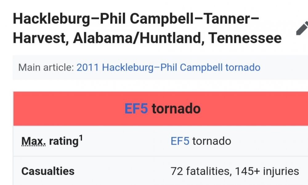
Yep. The tornado history site counted them as Tennessee F5. I believe 3 of the F4 also started outside of Tennessee on there so not sure if they were F4 in the state or not. The other 29 F4 formed in Tennessee.
-
18 minutes ago, jaxjagman said:
There's only been one confirmed F-5 in Tn since 1950,that was the Lawrenceburg one,now if you want to consider parts of Northern Alabama as parts of the Valley,i'd agree with you.Its really insane tho if you look at North Alabama per capita how many F-5'S they had,that's just crazy
I believe the tornado history site mistakenly counted this one and one from the April 1974 outbreak that crossed from Northern Alabama into Tennessee.
-
Strong wind and heavy rain, but didn't seem to actually have lightning or thunder here.
-
2 hours ago, CheeselandSkies said:
That can't be right. There were at least that many F4+ in the state on April 16, 1998 alone, plus several E/F3+ on days like Veteran's Day 2002, May 4, 2003, Super Tuesday 2008, and April 27, 2011.
There have been 92 F3, 32 F4 and 3 F5 in Tennessee.
-
1
-
-
Euro builds a block in the Atlantic but a giant Rockies ridge and N Pacific trough. Not great look for us, better for the areas east of the Apps. Far far perfer a better Pacific.
-
68 here today, about as warm as it ever gets in January. Rain is getting close, probably won't make 70.
-
Pretty good snow mean again on the GEFS.

-
Still cold but not as cold on the 00z GFS. Active southern stream too, about all you can hope for in late January.
-
You can get better than those indices but not much better and its really rare. We can definitely work with a neutral NAO with the EPO and PNA working for us.
-
5
-
-
The GFS has thrown us all a bone in the past 24-36 hours. The 18z even bullseyes Chattanooga. Plenty of moisture likely, plenty of cold possible. The eternal struggle in the area is getting them to meet.
-
3
-
-
The MJO takes a trip from 7 to 8 at pretty high amplitude on the GEFS, 7 into the 8 cod on the Euro. CPC notes that the GEFS is usually too amped in the western Pacific, the Euro too weak, so says to split the difference, which would be low amplitude 7-8. If we can have a stocked up Canada with cold, that should produce fireworks of the wintry variety.
-
7
-
-
Of course the Euro throws a turd in the punch bowl. Ugly Pacific. None of the blocking the GFS/GGEM shows.
-
1
-
-
Kuchera through the end of the GFS is just monster to crusher over 50 miles east to west. Looks like maybe an inch in Nashville but 10 in Cookeville. probably 4 or 5 in Murfreesboro. Just west of Nashville a dusting or bare ground. Eastern areas 12+, even near 10 in Chattanooga, 6-8 over alot of Alabama, even 12ish towards Atlanta that run.
About 5 runs in a row with various areas getting major winter weather but with precip and temps.
-
-
The GFS must have ran off EPS member 50. Buries Plateau and east. Unfortunately high and dry for the western areas for the most part. Not that its likely to play out as modeled. But lots of cold, storm signals abound and massive Pacific blocking.
-
1
-
-
00z GFS is showing the negative side of massive blocking in the valley. Gulf coast areas see frozen while we are cold and dryish.
-
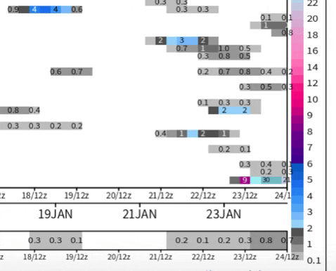
Just now, Carvers Gap said:
This was shared in the MA forum. Very good look at the MJO progression from today's modeling.
It's speeding up through 4-5. Going high into 7 has a high correlation to 8-1. Lots of SE winter storms happen in 7 and 8.
-
4
-
-

Break out the vodka. This is noon/1pm temps.
-
2
-
-
Weeklies say goodbye to the heat after this next 7 days or so. After that it's BN to N for the rest of the run.
-
2
-
-
My snow depth on the 23rd is 24 inches on member 50, dang compacting.
-
30 minutes ago, Holston_River_Rambler said:
I could live with that! I'm going to start getting bread and milk now.
-
1
-
 1
1
-


December/January 2019/20 Winter Speculation Thread
in Tennessee Valley
Posted
The Euro Ensemble isn't quite what the GEFS is but its not terribly far off on snowfall output.
The Euro OP popped a big East based -NAO. Not the best look for here compared to a west based NAO but better for the western Valley than the Eastern. The midwest does best in east based NAO events. Cutters or Apps runners or Bs are more favored. The Euro has a Rockies ridge that manages to keep the entire SE cold. Normally the Apps and East have AN temps with the east based NAO.