

Damage In Tolland
-
Posts
110,563 -
Joined
Content Type
Profiles
Blogs
Forums
American Weather
Media Demo
Store
Gallery
Posts posted by Damage In Tolland
-
-
Just now, ineedsnow said:TodayMostly cloudy, with a high near 67. Light east wind.TonightMostly cloudy, with a low around 50. Light east wind.MondayPartly sunny, with a high near 71. Calm wind becoming southeast 5 to 7 mph in the afternoon.Monday NightPartly cloudy, with a low around 52. Southeast wind around 5 mph becoming calm in the evening.TuesdayPartly sunny, with a high near 72. Calm wind becoming southeast around 6 mph in the afternoon.Tuesday NightA chance of showers, mainly after 11pm. Mostly cloudy, with a low around 59. Southeast wind 3 to 5 mph. Chance of precipitation is 30%.WednesdayMostly cloudy, with a high near 79. Southwest wind 5 to 7 mph.Wednesday NightMostly cloudy, with a low around 64. Southwest wind around 6 mph.JuneteenthA chance of showers before 2pm, then a chance of showers and thunderstorms between 2pm and 4pm, then showers likely and possibly a thunderstorm after 4pm. Mostly cloudy, with a high near 83. Southwest wind 6 to 11 mph, with gusts as high as 21 mph. Chance of precipitation is 60%.Thursday NightShowers and thunderstorms likely before 8pm, then a chance of showers between 8pm and 2am. Mostly cloudy, with a low around 62. West wind around 8 mph. Chance of precipitation is 60%.FridayA chance of showers. Mostly sunny, with a high near 77. West wind around 10 mph, with gusts as high as 20 mph. Chance of precipitation is 30%.Friday NightPartly cloudy, with a low around 56. West wind 5 to 7 mph.SaturdayMostly sunny, with a high near 78. West wind 6 to 9 mph.
NWS Point and clicks ? I mean is that what’s you’ve come to? Sad to see this happening
-
 1
1
-
-
Next 5 days go from 70’s to 80’s to 90’s . Try harder ACATat
-
39 minutes ago, wdrag said:
Good Sunday morning, Heat is obviously coming now and interiors slated for an above normal number of 90+ days in June.
Thursday may be a heat advisory afternoon for interior NJ (EWR etc). Also mixed layer Cape over 1500J with Bulk Shear >30 kits suggests potential for SVR. Timing timing timing.
Then the heat wave, first of the year probably for most of us except water influenced coastal spots (Sunday-approximately around Wednesday of next week), possibly longer with widespread heat advisory conditions early next week, possibly a heat Warning coming for some spots. Interestsingly enough while ML CAPE is high early next week, Bulk Shear is low so any SVR Thunder may be more isolated, local convergence initiated.
Recent abo e normal rainfall and another event coming before the heat... that will help with higher dews and possibly lower max temp potential a deg or two. Nevertheless, HOT looks to be on the way.
We Walt
-
 2
2
-
-
16 minutes ago, CoastalWx said:
AN as fast as the eye can see starting mid week. Summer is here.
ACATT will try and poke and post holes in that today.
-
 1
1
-
-
3 minutes ago, ineedsnow said:
Meh it's like in winter when models show a great pattern and snow chances on day 10 only to go to crap.. also models have been showing heat in the extended for 2 months now and nothing to show for it.. maybe this time works out though
They haven’t shown any sustained heat like this. Not once .
-
1 minute ago, Torch Tiger said:
he means Septdewber, months from now it'll relax
And honestly it’s probably more likely mid/ late Octorcher
-
13 minutes ago, ineedsnow said:
There is though
Not on any ensemble guidance
-
1 minute ago, ineedsnow said:
hoping we can manage some big storms at the end of it
Well the thing is.. there really is no end
-
 1
1
-
-
22 minutes ago, kdxken said:
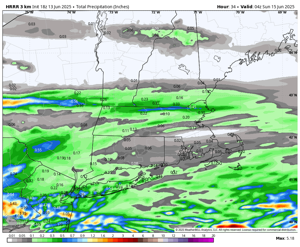
Looks like .5 - .6 will just about do it.
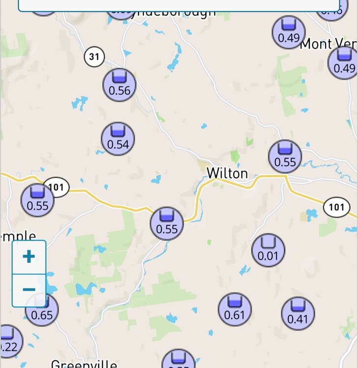
Not sure where that is but SNE General was under .15. A terrible job by anyone calling for rain and using euro
-
Even Ineedsnow is excited and become Ineedheat
-
3
-
1
-
-
Oh yeeaaaahhhh boooyyyyyy
-
1
-
-
39 minutes ago, dendrite said:
Take those dews up. Plenty of 70+ coming starting late next week.
There’s way too much taking model output and machine numbers verbatim. One look at that ridge and thicknesses from Thursday onward thru end of month shows high dews and steamy . Could be a day after a severe outbreak that dries a bit , but dews right back into 70’s after . It’s like when the charts are posted. Most know those aren’t correct and to add 5-8 degrees on at least
-
It’s a HHH pattern folks.
Deal With It
- Cosgrove
-
18 minutes ago, CoastalWx said:
Stein finally came.
Didn’t someone say 6z Euro qpf was usually right the day before?
-
.03 lol. Not wet a bit under the trees. Just about over too . Stein showing life
-
HRRR FTW
6z Euro yesterday FTL @Ginx snewx
-
7 minutes ago, Torch Tiger said:
Anything EML-driven, rules go out the window.
 I would say not much to look at for sig severe, tho:/.
Both Gfs and Euro have periodic EML here starting late next week
-
Tor’s Tiger ?
-
Drive by some homes that don’t prune their bushes and look at ones that do . It’s amazing the difference in terms of aesthetics and perception
-
1
-
-
54 minutes ago, CoastalWx said:
Who does weekly shrub pruning? wtf.
Anyone that cares about how their landscape looks . If you don’t keep up with it this time of summer , it over grows very quickly .
-
 1
1
-
 1
1
-
 1
1
-
-
1 hour ago, powderfreak said:
That’s 12z too… the 18z is even drier.

You wonder if many even measure?
-
1 minute ago, Torch Tiger said:
CT Rain person said no severe, laughed at that assertion days ago
Texts today say quite different
-
A whole lot of Meh tomorrow morning . Most end up under .25
https://x.com/ericfisher/status/1933533264506917342?s=46&t=dhcbvkjmRcyBVQtDxJ3lRg
-
76. 1 for the high with mostly sunny/smoke . A solid day to do the lawn and weekly shrub pruning. Let’s get thru tomorrow and the torch summer awaits us mid week on. Along with severe

June 2025 Obs/Disco
in New England
Posted
ACATT never fails to disappoint . As foolish as they make themselves look