

Damage In Tolland
-
Posts
110,410 -
Joined
Content Type
Profiles
Blogs
Forums
American Weather
Media Demo
Store
Gallery
Posts posted by Damage In Tolland
-
-
5 minutes ago, dendrite said:
41° off of a high of 44° at the STEM today. Nice day.
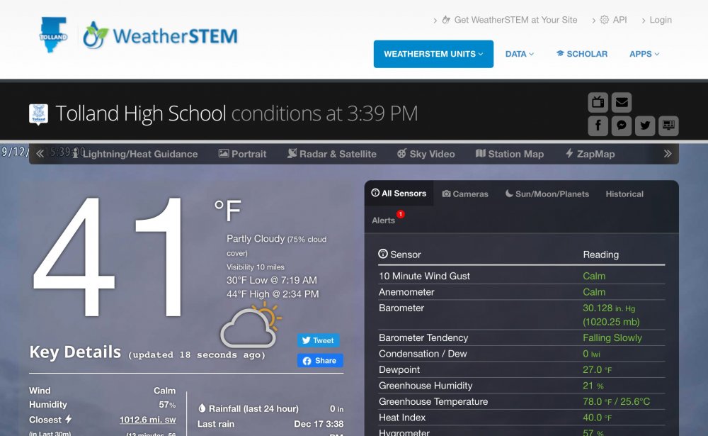
38.7 was our high. Now 36.9/ 27
This area is probably the most difficult to make a forecast for in all of SNE. Couid be 31-32 almost the whole time with . 50+ or couid be minimal with 32.9.
-
I don’t see any Obs showing mid 40’s in CT. Even IJD is only 43 and HFD 42 Sell that ob in Woodstock
-
37.8/26 LFG!!!
-
 2
2
-
-
Just now, 40/70 Benchmark said:
I disagree with the bolded....short-term mesos often play catchup with that as we close-
Still maybe under-modeled....again, this is low level cold.
We are all cooked for snow in SNE.
Even he’s getting siggy ice in Southington
-
Leave it to MPM to downplay a significant icestorm over a relatively large area of NW RI/ NE and NW CT all the way up to VT and east to ORH and says it will impact 3-4 posters. Better check the HREF
-
 3
3
-
-
34.2/27
-
1 minute ago, ORH_wxman said:
ORH is an interesting forecast. They have a pretty high max temp in the warm layer...which usually tells me to go ZR...but the cold layer below it is deep and gets to around -6. That's clear sleet there.
So which method do we give more weight to? Typically when the warm layer gets higher than 3C, you're gonna go ZR...but when the cold layer goes to -6C or colder, it's sleet. But in this case a lot of guidance has both occurring around the ORH area.
You still watching dews today to see where they are late today ?
-
Kind of just a play it by ear. I guess like Will said if these low dews today in the 20’s are still in place tonight.. things could get interesting. HREF really gives in on the elevation dependency
-
 2
2
-
-
10 minutes ago, Ginx snewx said:
Small lies to big lies, false accusations of emotions, false interpretations of posts, attempts at making up things I never said or implied, all to achieve your agenda. Tried and true method of your posting to many many members here. Accuse them of stalking you. You want to play the game we can play. It's like feeding candy to a baby
I’ll just cease my interactions with you if this is the case. Good luck to you on the storm
-
 1
1
-
1
-
-
Not sure what I did to upset Ginx , but man is he out to get me . Attacks here and Twitter today. Good luck to everyone as we near the event
-
 1
1
-
 1
1
-
2
-
-
5 minutes ago, ORH_wxman said:
And the models may not have the lower dews advecting southwest far enough. They typically can't resolve the lowest 1000-2000 feet on such a sloped airmass.
Still about 24 hours to see any late trends though. The whole thing could still bump north or south...weaker or stronger.
I give up .He wants so badly for our area to miss the ice. Maybe he’s right and it’s 34 ad rain . Time will tell. Seems snow idea is gone even up into NH
-
We are begging you sir , please put the models and readings away. They aren’t going to capture this. Please
-
1
-
4
-
-
Put model estimations away on this one. It’s been reiterated
-
1
-
-
Just now, CoastalWx said:
You are borderline
On the Euro . And as all you mets have been hammering .. models well under doing the cold Thrust .
We thrust and push
-
More importantly how’s the surface in icestorm region and could it be over or underestimating cold thrust?
-
So naked. So free
-
1
-
-
Buns flying like Helloween candy. We take!
-
1
-
1
-
-
This is a fantastic AFD. Gives you the Drag “chills” feel reading it
Per collaboration with surrounding NWS offices, Winter Storm Watches
are now hoisted for western and central MA into northern CT. This is
mainly due to the potential for a prolonged period of freezing rain
and sleet. Though sensitivity to low-level thermal structure and
precipitation type changes results in some uncertainty in forecast
ice and snow/sleet accumulations, model solutions are coming around
to the idea of potentially significant icing with potential for tree
damage, power outages and transportation impacts in the Watch
area.

First part of this expected precip event looks to affect the region
starting Sunday evening. Warm-frontal precipitation is expected to
overspread from central and southern NY into Sunday night. Though
surface temperatures initially support rain as a predominant weather
type, northeast ageostrophic flow related to an in-situ high
pressure ridge/wedge over ME/NH will draw increasingly colder/sub-
freezing low-level air southwestward mainly across areas north and
west of Interstate 495. This process will facilitate a changeover
towards sleet and freezing rain in these areas, with warm-nose
temperatures between +1 to +4C following the ECMWF/NAM guidance.
Surface ridge over northern New England remains essentially in place
through most of the first part of the event, and this will maintain
and lock in sub-freezing surface temperatures across several hours
in these interior areas. Precipitation appears most focused with
this first portion of the event during the pre-dawn into Monday
afternoon hours with impact potentially to both commutes. In this
period, of some concern is NAM-based guidance indicating a corridor
of elevated instability (up to 150 J/kg) on the nose of a SSW low-
level jet of 40-50 kts, which may help to enhance freezing rain and
sleet accumulation rates. Temperatures across most of the South
Coast and near/SE of I-95 should remain above-freezing supporting
predominantly rain.

Later Monday night, surface winds become east to east-southeast as
we await the second part of this event, taking the form of a
developing coastal cyclone that looks to progress from the east
coast of NJ towards SE MA by 12Z Tuesday. While the GFS remains on
the eastern/offshore side of the guidance envelope regarding this
system, ECMWF ensemble membership is rather tightly clustered either
near the MA E coast or inland. A closer-inland track appears
preferred and follows the ECMWF/GEM solutions.  System looks to pull into
coastal Maine by the evening of New Years Eve, with winds becoming
westerly and cooler air filters in on west winds.

The Winter Storm Watch was hoisted in areas where significant
freezing rain accretions are possible, with amounts up to a half-
inch forecast. It sometimes can be difficult to reach Warning
criteria purely from freezing rain accumulations alone. Small
changes to low-level thermal structure will make significant
differences in observed sleet/freezing rain accumulations, and
pending subsequent QPF and accumulation trends, some of those
areas currently in the Watch may end up becoming converted to
Advisories on that basis. The potential exists for significant
icing in portions of the Watch, however, and this is especially
the case for parts of the hills in Worcester and Tolland/Windham
Counties and into the eastern slopes of the Berkshires given
northeast/east upslope flow. Indeed, trending on the lower end
of that range by aftn.ndividual NAM/ECMWF/GFS model guidance
freezing rain accumulations are quite substantial, and while
likely overdone, in some cases are over three- quarters of an
inch. Further expansion of the Watch could be needed in
subsequent updates.
-
1
-
9
-
-
Newly updated WSW
URGENT - WINTER WEATHER MESSAGE
National Weather Service Boston/Norton MA
400 PM EST Sat Dec 28 2019


CTZ002>004-MAZ002>004-008>012-290500-
/O.EXT.KBOX.WS.A.0007.191229T2300Z-191231T1800Z/
Hartford CT-Tolland CT-Windham CT-Western Franklin MA-
Eastern Franklin MA-Northern Worcester MA-Western Hampshire MA-
Western Hampden MA-Eastern Hampshire MA-Eastern Hampden MA-
Southern Worcester MA-
Including the cities of Hartford, Windsor Locks, Union, Vernon,
Putnam, Willimantic, Charlemont, Greenfield, Orange, Barre,
Fitchburg, Chesterfield, Blandford, Amherst, Northampton,
Springfield, Milford, and Worcester
400 PM EST Sat Dec 28 2019

...WINTER STORM WATCH IN EFFECT FROM SUNDAY EVENING THROUGH
TUESDAY AFTERNOON...

* WHAT...Heavy mixed precipitation possible. Total snow
  accumulations of a coating to two inches and ice accumulations
  of around one half of an inch possible.

* WHERE...Portions of northern Connecticut and central and
  western Massachusetts.

* WHEN...From Sunday evening through Tuesday afternoon.

* IMPACTS...Power outages and tree damage are likely due to the
  ice. Travel could be nearly impossible. The hazardous
  conditions could impact the morning or evening commute.

PRECAUTIONARY/PREPAREDNESS ACTIONS...

Monitor the latest forecasts for updates on this situation.
-
1
-
-
Href and 3k in lock step

-
7 minutes ago, moneypitmike said:
No snow until Jan 20??
There’s a reason why that was forecast
-
14 minutes ago, weathafella said:
First third looks pretty mild. Hopefully we turn around thereafter.
I’m not sure where the 7th date came from but you can toss first 15 days
-
1
-
-
1 minute ago, Ginx snewx said:
He will
All rainer
-
6 minutes ago, CoastalWx said:
EPS actually may be a hair colder vs the op.
Oh noes
NYE Mess Obs
in New England
Posted
36.0/27
Wonder If it starts as sleet ?