KokomoWX
-
Posts
1,560 -
Joined
-
Last visited
Content Type
Profiles
Blogs
Forums
American Weather
Media Demo
Store
Gallery
Everything posted by KokomoWX
-
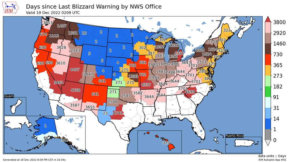
No change here (IND NWS) but others got blizzard warnings.
.thumb.png.9a1c3b9cb636e889536ce79405d7369f.png)
-

Pre-Christmas (Dec 21-23rd) Winter Storm Part 2
KokomoWX replied to Chicago Storm's topic in Lakes/Ohio Valley
I had a friend who asked if I could drive her into town today. I obliged. The wind and temperature were wicked. We saw a lot of mini drifting and some whiteout conditions. I explained everyone dodged a huge bullet low snow totals. Of course she sensed my disappointment with this storm but was thankful it didn't materialized. -
I had low expectations for snow totals but it has managed to even miss that. I’m just tired of it all. Life is hard and the weather disappointments just add to it. I hope we torch next weekend. .
-
Pre-Christmas (Dec 21-23rd) Winter Storm Part 2
KokomoWX replied to Chicago Storm's topic in Lakes/Ohio Valley
Mixed rain/snow has made it to Kokomo. . -
Pre-Christmas (Dec 21-23rd) Winter Storm Part 2
KokomoWX replied to Chicago Storm's topic in Lakes/Ohio Valley
Awaiting for the storm to begin all while dealing with a failed air conditioner for a data center. -
Pre-Christmas (Dec 21-23rd) Winter Storm Part 2
KokomoWX replied to Chicago Storm's topic in Lakes/Ohio Valley
Not at Pivotal. . -
Pre-Christmas (Dec 21-23rd) Winter Storm Part 2
KokomoWX replied to Chicago Storm's topic in Lakes/Ohio Valley
Brutal for my snow hopes and dreams. -
Pre-Christmas (Dec 21-23rd) Winter Storm
KokomoWX replied to Chicago Storm's topic in Lakes/Ohio Valley
Interstate 65 north of Indy is frequently a mess without snowy (or near blizzard) conditions. I'd avoid Friday travel. -
While the big story is the pre Christmas storm, the winter weather fizzles afterwards. The GFS is not serving any fantasy storms other than a duster around the 28th. When the new year begins, we torch...
-
Let's compare this in a week...
-
Pre-Christmas (Dec 21-23rd) Winter Storm
KokomoWX replied to Chicago Storm's topic in Lakes/Ohio Valley
The duration of winds well past the Christmas weekend is pretty amazing besides the snow. I am riding the current eastern edge and hope for a shift back east before this begins. The NW trend is not my friend. -
It's not for me.
-
Winter 2022/23 Medium/Long Range Discussion
KokomoWX replied to Chicago Storm's topic in Lakes/Ohio Valley
Some Ohio peeps would be so overjoyed if that was even half true. I can also support this solution. -
Yep. It's pretty dull for the foreseeable future. I cannot remember when I had a good winter.
-
In season No preference. Windy! Continuous 18" of fluff over 36 hours or 12" of cement in 12 hours Bitter! Meh, anytime is fine. N/A I want to keep the snow and build some snowpack. Melting right after is awful.
-
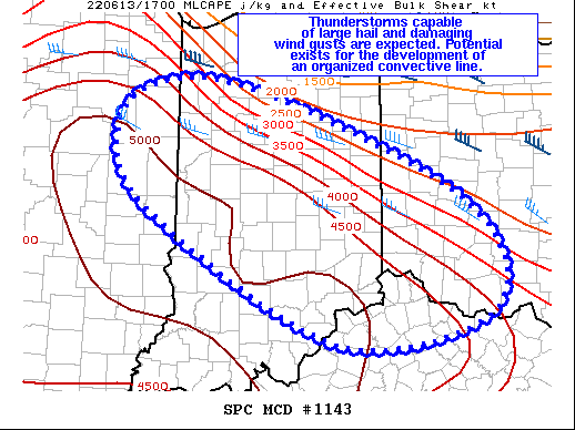
Mesoscale Discussion 1143 NWS Storm Prediction Center Norman OK 1229 PM CDT Mon Jun 13 2022 Areas affected...East-Central IL...Central/Southern IN...Southwest OH...Northern KY Concerning...Severe potential...Watch likely Valid 131729Z - 131930Z Probability of Watch Issuance...80 percent SUMMARY...Strong to severe thunderstorms capable of large hail and damaging wind gusts may develop over the next few hours. Potential exists for the development of a convective line capable of strong wind gusts. DISCUSSION...Recent surface observations across the Lower/Mid OH Valley sampled a very moist air mass, with dewpoints in the upper 70s/low 80s. Surface temperatures across this region have reached the low 90s. These low-level thermodynamic conditions beneath steep mid-level lapse rates is contributing to extreme instability. Recent mesoanalysis estimates MLCAPE over 5000 J/kg and recent RAP soundings show a surface-based LI of -13 to -14 deg C. Mesoanalysis also indicates convective inhibition has eroded across much of the region, despite very warm low to mid-level temperatures. An area of deeper cumulus has developed just northeast of the strongest buoyancy, in the open warm sector well southwest of the warm front. Mesoanalysis reveals this cumulus is within an area of modest moisture convergence likely resultant from a subtle wind shift. Lighting has also been noted within this region during the last half hour. Given the thermodynamic conditions, very strong updrafts/downdrafts are possible. Moderate vertical shear is also in place, suggesting storm organization is possible. Evolution of this development is still uncertain, owing to the weak large-scale forcing for ascent and warm low to mid-level temperatures. However, the overall pattern and presence of extreme buoyancy suggest the potential exists for the development of a well-organized convective line. Most likely corridor for progression of this line would be across central/southern IN and into southwest OH and adjacent northern KY. ..Mosier/Guyer.. 06/13/2022 ...Please see www.spc.noaa.gov for graphic product... ATTN...WFO...ILN...LMK...IWX...IND...LOT...ILX...
-
2022 Short/Medium Range Severe Weather Discussion
KokomoWX replied to Chicago Storm's topic in Lakes/Ohio Valley
I was at Credit Union 1 Arena Saturday for a 3 1/2 hour marathon of Rush University's Commencement which began at 2 PM. The ceremony went continued after the warning but when it was over, I turn around from photographing the hooding portion to find an almost empty arena. Pretty crazy to see that. By the time I packed up, the sun was out. I drove home in between the storms but was treated to a crazy light show almost the whole way after a dinner stop in Merrillville. -
This thread should be dead. It's April for goodness sakes. Stupid winter hanging on.
-
Nuisance level at best. I'll take sunny and spring like over the continued polishing of the 21-22 winter turd.
-
Rain for wave one, a miss south for wave two. Sigh. It wouldn't be as bad had the model not hinted at something near historic for days. When does spring start again?
-
I done disagree. So much rain and lost potential. We have switched over and it is coming down hard. I tossed us a live stream before going home for the day.
-
-
I feel pretty good about my chances for 12+ inches. I was worried earlier about being on the sharp southern cut off (and possibly ice) but that has passed. Anything less than 10" will be a bust in my mind though.

-
Thanks. I updated my original post.
-
For those interested, here is a nice video on the upcoming storms. ("professional meteorology analyst") He did a nice job on the recent nor'easter.

.png.0fbf7b160639d61ca27fad8d30e3d434.png)