

MJOatleast7
-
Posts
309 -
Joined
-
Last visited
Content Type
Profiles
Blogs
Forums
American Weather
Media Demo
Store
Gallery
Posts posted by MJOatleast7
-
-
11 minutes ago, dryslot said:
Many times golfers get hit by a rogue bolt and storms are 5-10 miles away.
sometimes those are positive strikes from the anvil, much more powerful and deadly than the more usual negative CG strikes (although anvil strikes are not the only way to get positive CG strikes)
-
1 hour ago, HoarfrostHubb said:
What is the name of the phenomenon Tip mentioned last summer when the sun is behind convective clouds and the edges are lighting up.
Crepuscular rays?
-
10 minutes ago, weatherwiz said:
The AO forecast is beyond ridiculous...+6 to +7SD....yikes
curious that the NAO forecast isn't so extreme...especially considering Dennis (915 mb tomorrow approaching Iceland-wtf) and the general pressure field hanging around there until Sunday
-
30 minutes ago, Baroclinic Zone said:
Maybe we can get Taal to change the pattern
Of course, immediately after that, we had a summer with no 90s in Boston (the first one ever) followed by 3 out of 4 winters being epic.
-
26 minutes ago, Baroclinic Zone said:
Maybe we can get Taal to change the pattern
Taal is a tropical volcano. Normally in such a case we'd have 8-12 months of tendency toward +NAO following the eruption, followed by colder. We had the same thing from June 1991 - March 1992 after Pinatubo (in almost the same region) erupted.
-
 1
1
-
-
Lol..no need to dilute 2015 one bit!
Slurpee waves in Nantucket Sound?
. -
55 minutes ago, Typhoon Tip said:
If the GFS and Euro are right ... Sunday is not the warmer day there. That's a contaminated/dirty misty warm sector with light rains and failed convection on radar, with abhorrently elevated DPs ( probably 57 -ish) for this time of year.
The products that are supposed to hone in on those metrics may or may not show that, but experience alone...I've seen that look before and the mild day would be Saturday ...when less contaminated warm sector flow is well mixed and b-layers are about as tall as they can get at this time of year.
If we get > 75% RH at cloud heights and mist, and 68 F anywhere around here on Sunday, we've definitely CC thresheld and you ain't getting winter ever again
")
Hyperbolic kidding of course
Cue the dark yellow Venus surface flyover with continuous lightning and Patrick Stewart voiceover.
-
40 minutes ago, Typhoon Tip said:
That's how you run a -EPO downloading ...
and also how you run a LES event. Watch out Houghton, MI to Tug Hill if that happens.
-
1
-
 1
1
-
-
1 hour ago, 8611Blizz said:
That little bit of snow above the U.P. is that the shit streak or is that somewhere else in the bowl?
Looks like LES
-
1
-
-
Yeah. Dec '92 broke the drought for me and then we had some amazing winters there for a time before the little lull in late '90s.
Took Pinatubo to do that. The snow we got in April 92 and the summer without a 90F at BOS we’re a result of that event, and followed 9 months of the obligatory NAO+ that accompanies a tropical volcanic eruption.
. -
4 minutes ago, Typhoon Tip said:
Here's what's gonna happen...
Over the next circa decades, maybe sooner, maybe later ( picking which one based upon some assholier than thou head up the buttness reality we need to believe in...) the HC will have expanded to engulf the mid latitudes ... Around that time, the polar regions will have warmed so vastly - or vastly enough .. - that they no longer impose the same ambient gradient girdled to the warm height regions of the planet. The flows will relax everywhere. Prolly 200 years ... who knows.
0.5° per decade is the current rate I see most often quoted. So 200 years is 10° farther north or 600 n mi. Nova Scotia would be the new secondary cyclogenesis point in miller B's and we play the role that Hilton Head, SC plays now.
-
8 minutes ago, Typhoon Tip said:
This is cool lookin' Below is a cut-away of the 270 .. someodd hour of the GFS over the Great Lakes, 500 mb synoptic snapshot. Note the ovoid annotation? Those are 150 to 160 kts indicators on those wind flags.
If one were in a commercial airliner ... with a typical thrust velocity around 525 mph and were flying at the 500 mb sigmal level, your 'ground-based speed' would be Mock 1 - the speed of sound
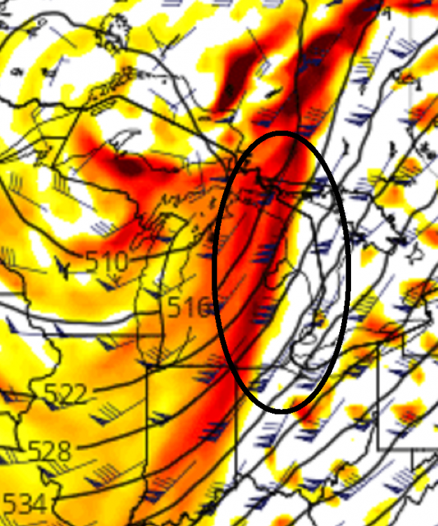
sonic booms from SW-bound planes?
-
1 minute ago, Snow88 said:
Gfs is amped for next week
Too amped for the coast
HC expansion = amped -> damped.
-
6 minutes ago, weathafella said:
Remember the back door with temperatures remaining in the 70s at Logan. That’s how you know you’re living large....late March door and 74 degrees out...
Also (may have been the same event) March 2012, when the NStar transformer blew on Scotia St in the Back Bay and we all walked around a darkened Boston in shirt sleeves.
-
25 minutes ago, Typhoon Tip said:
Oh yeah...that was a dream scape incarnate... man.
Actually, there was another year where April was pretty balmy back then... earlier. Wanna say aught-9 or 10 perhaps. We had the March floods in 10 then I think April came along with an unusual dearth of BD fronts and that kept it tepid, and then in May we popped a 95 day in a long stretch of ridic warmth, one that even ended with a supercell over Middlesex Co that flickered continuous lighting underneath a full moon as it swept clean to the southern horizon - never saw a specter like that sky to earth... Good era for springs in there.
That's ancient history. Funny...a co-worker and I were just musing about that at lunch, how it's been a number of years since we've had that kind of balmy spring. What's interesting - if fair to mention - is despite some of these rancid springs, we've actually had some bizarre early heat ... Remember February a couple clicks ago, we had a run in the 80s ... then, snow storms in March that I loathed and despised ... But we also had a March warm spell one year, also touching 80 ... both those years witnessed recidivism back into winter crime... and I consider 42 F mist for two weeks in May murder!
Suppose that type of spring you're citing there is too exceptionally rare to ever expect that. It's the antithesis of 1995 front loaded winter. There's a reason there's only be one or two of them in the memories of those alive.
We still get 40 to 45 days to make this fugger work this year... Then I'm out. In that time... yee haw... ya.. Boo ya... I'm all in ... let's do it.
Anecdotally and to some degree backed by actual data...is that a good predictor of early heat in spring...and maybe the following summer...is a true ratter winter like 2001-02 and 2011-12. 2001-02 was followed by 89F (BOS) on the last day of March and 93F on April 17 (although that was the day of the infamous undular cold bore/BD that capsized boats in Boston Harbor and caused a 40 F drop in a few hours) 2011-12 had 3 days of 100+ centered on July 22 featuring the second-highest reading ever at BOS (103F)
Time will tell if this winter rats out and maintains the correlation (if there is one) in an early/hot spring (though not immune to raging BD reversals) but what 2001-02 and 2011-12 had that this season doesn't have (so far) is a wicked cold NE PAC. So this may not be a third example.
-
2 hours ago, Ginx snewx said:
Nice trends on LR modeling looks like around the 15th 16th Teleconnections improve dramatically. Tanking NAO AO EPO with a neutral PNA. 2/3 snow threats prior with a early Jan thaw week. Buckle up
MJO still needs improvement, but not quite so much looking like it wants to camp out all month in 4-5
How far does your source go out? PNA isn't exactly cooperating at least until Jan 16 according to CPC
-
So...E trade winds at BOS by summer 2030?This is a GW/ Hadley Cell bulge into a winter BD scenario.
All fields exaggerated because of that and you end up with huge polarity.
All these lows are doing this now… I can direct you all the papers showing how the storm tracks all over the hemisphere suspiciously being pushed north because of the HC expansion with global warming. It’s fn up the winters. Also the flow being so fast is definitely having an influential impact on cyclones frequency and amplitude
Sent from my iPad using Tapatalk -
3 minutes ago, CoastalWx said:
It’s OK. I still don’t like Alaska.
or the 594 ridge in the Atlantic
-
Just now, Minenfeld! said:
I had co-workers complaining about how cold it was like a week after that. Meanwhile, the cherry trees started blooming the week before Christmas.
I saw a US map back in the 70s (I think) that showed the northern possible limit of palm trees around Cape May, NJ. Wonder where that limit is now, or where it will be in the near future.
-
18 minutes ago, Lava Rock said:
38f. Milky sun, birds chirping, snow melting. What's not to like?
'cept this torch is supposed to be like that in Moosonee, ON
-
53 minutes ago, Snow88 said:
2 day warmup on the euro
Drawing the shades post/12/23 or so but leaving 'em open just a crack.
-
 1
1
-
-
32 minutes ago, WinterWolf said:
Ya that’s 6” of snow..
A lot of that is probably LES
-
2 minutes ago, ORH_wxman said:
Yeah....RPM is also getting into the range where its actually useful.
RPM along with the other shorter term guidance is starting to pick up on a pretty good thump further south too....for S CT. Prob gonna see advisory snows for most of SNE with a stripe of low end warning somewhere.
the pike still favored
-
Pacific def looking better on GFS toward NYE

Saturday, June 27 - Sunday, June 28, 2020 Convective Thread
in New England
Posted
Storm just exploded over me in Winchester. Three nasty CG strikes in 2 min
Sent from my iPad using Tapatalk