

MJOatleast7
-
Posts
321 -
Joined
-
Last visited
Content Type
Profiles
Blogs
Forums
American Weather
Media Demo
Store
Gallery
Posts posted by MJOatleast7
-
-
15 minutes ago, Great Snow 1717 said:
They must have a death wish...
This is probably next:

-
 1
1
-
-
you mean the Mystic River, right?
No, the Pamet River in Truro.
.-
 1
1
-
1
-
-
4 minutes ago, WxWatcher007 said:

Big drought isn’t possible here, despite what some say

No creepy remains showing up at the bottom of the Quabbin?
-
73F at BOS on 1/12/2020.
-
Contrary to what it looks like, someone IS actually in charge of this upcoming period and ultimately answerable for keeping it on track:

-
1
-
-
The ridge or western North America is also bulging east more aggressively on some of these guidances. That’s probably more important in where this thing ultimately locates in the west east aspect.
but the sp Vortx stuff going on north is very important for how our boundary layer conditions will be as well and if it gets strong enough it will ultimately stop this thing from going up in Ontario altogether and we end up with a whole different scenario anyway
Yeah’ hopefully it’s enough to prevent a 955 low from curling up onto Hudson’d Bay and spinning there for 3 days…mixing out/eating up all the cold reservoir up there…setting up our post-12/28 thaw…
.-
1
-
-
Just looked at Euro OP... piecemeal phasing that spreads the wealth in space and time, but close to a much bigger hit if that shortwave diving to Carolinas caught up
GEFS+EPS look great
Obviously the best signal we've had this season...
Gonna be alot of distracted folks at upcoming holiday parties
I was that way at Thanksgiving about 8-10 years ago. Comet ISON was due to pass close to the Sun (less than a million miles) that day and be the brightest comet ever a couple of days later. Instead, it completely disintegrated when closest to the Sun. I was inconsolable and not much fun to be around during T day. Astro geek instead of weather geek, but yeah, same idea.
Sent from my iPad using Tapatalk -
10 minutes ago, 8611Blizz said:
Who will run these camps? I nominate Will and Scooter?
Uyghurs gonna Uyghur...
-
That’s a cold and awesome look in the long range. One potential point of concern, as some utility companies have pointed out, is strained LNG supplies that could lead to disruptions and blackouts if we get sustained anomalous cold. Hopefully that doesn’t pan out.
12/25/1980?
. -
1 minute ago, ORH_wxman said:
Ukie has the shortwave but it gets sheared out....it does produce some onshore flow and SN- for like 40 hours though, lol.
Which would be drizzle for us in BOS. How exciting.
-
1
-
-
All that chaos and then a subtropical system in the central Atlantic. Gotta wonder ifTHAT can be a player too, torquing the flow into a 50/50 low or something like that. Right now it's too far east and only temporary.
-
1
-
-
Looks like crazy velocity though - whatever forms should be quick hitting
-
1
-
-
East money. Obviously the last minute explosion was wild but the environment was primed for a big dog. You could see it from a mile away.
Still thinking October produces a couple good storms too if we can get some seeds in the Caribbean.
Hurricane hunter report seemed to coincide with the RI that happened just before landfall. The observer said it was more lightning than he’d ever seen in his career as a hurricane hunter.
Sounds like the plane passed near or through a hot tower accompanying the RI. Would love to see the data from that pass.
. -

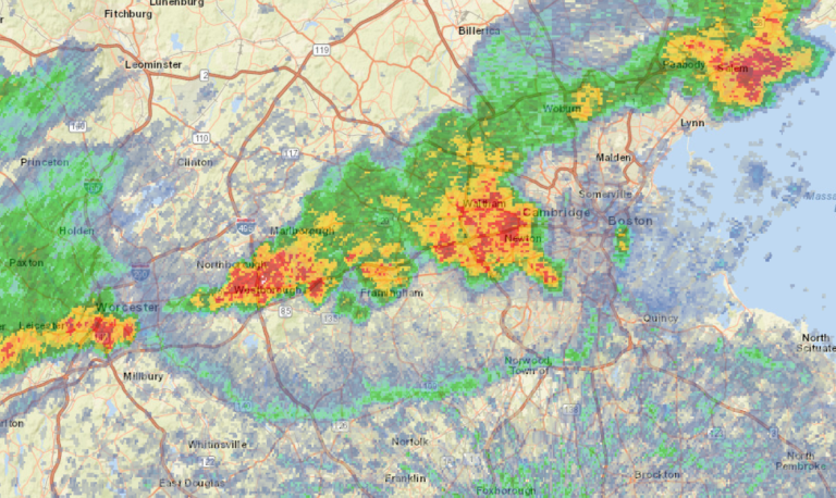
Winchester MA about 7:10
.-
10
-
-
Check out the outflow boundary (4:07 pm) on a sagging ORH-OWD line.
-
3
-
-
9 minutes ago, Whineminster said:
Yeah can't say I've been to that part of the bay, only like scusset and north Dennis, but I believe it. A taste of Florida your favorite place!!
Breakwater Beach n Brewster,man...over a mile of exposed sand at low tide, completely covered over at high tide. That's a lot of sun-baked real estate to warm the incoming water. It's a wonder we don't get tidal bores there like in Nova Scotia.
-
2
-
-
hope we get some water...
these last three convection windows have left much to be desired, regionally. And tomorrow, looking over guidance', it appears we'll still make the mid 80s but with a return of that desiccating air mass type. DPs of 50 with d-slope additional katabatic drying, waving through fields and trees in operation water sucking life right out of the background environment...
dry begets dry. I've always hated that statement, ... quite likely because it appears to be so true and it's my own petty hang-up. empirically, though, the data is what it is. Maybe just perception, I dunno. A dry period is dry so long as it stays dry or event roll out that way off the dice. And just like the crappes table, you can have successive lucky roles. Or maybe there are real physics at play. Maybe it's both - probably.
Call it whatever we will, trend also is a valid prognostic philosophy. So we should go ahead and assume the drier side until such time as the erstwhile mode has quite obviously changed. When? Oh ...probably when the first synoptic nor'easter in Sept or more likely nearing Halloween - which may snow again by the way ...
We'll be back to no drought condition by thanks giggedy.
Gee I hope we get a High Sierra scenario, where the first precip event of fall is snow.
Sent from my iPad using Tapatalk-
1
-
-
1 hour ago, SouthCoastMA said:
SST's are 80 along the latitude of Atlantic City. Of course, you'd need a tropical system to begin with and the perfect set up, but that doesn't scream weakening until late in the game.
It also depends how deep the warm layer is...If it's 80F through 200' of depth that's a lot better for maintaining TC strength than if it's, say, only 40-50' deep. Although since systems are usually trucking along at MA/SNE latitudes I don't really know if upwelling would still able to affect the storm as it passed.
-
Amazing seabreeze front at York Beach, ME today…ran into it coming back from Nubble light at Sohier park(73F) to 83 at the end of Nubble Rd 0.8 mile later, then 95 at the south end of Long Sands Beach. All within less than 2.5 miles. Earlier the front had been about 2 miles back from the coast but then bumped eastward to the beach about 6 pm.
.-
1
-
-
Nice seabereeze at Nubble Light in York, ME. 78 this afternoon.
Sent from my iPad using Tapatalk-
2
-
-
Day 5 of aoa 90 at Logan. Should hit 6 with a slim chance of 7. Longest streak in a while I think.
Since August 2002?
Sent from my iPad using Tapatalk -
kind of scary that we're getting these temps with such a blah upper level pattern. wait til we get a ridge like canada 2021 or what europe just had
Lack of soil moisture definitely plays a part, though. I don’t have any hard data, but I’m sure soil moisture is way down in the 20th percentile or so region wide. All the sun’s energy can go into heating the ground, and by extension the air, when there’s no water to evaporate.
. -
56 minutes ago, Typhoon Tip said:
Folks may roll eyes ( for some reason..) but it is still quite analogous to the SW/W heat release phenomenon that takes place across the N/A mid latitudes. Only in the western Europe paradigm ...rotate the dial 90 degrees.
This is/was, as their "big heat" tends to materialize, a N. African heat release. It was pulled through eastern Iberian Pen region/over the western Med Sea, and given to the anomalous split -flow jet configuration ( the N branch of which is buckled around a NW European ridge), it got pulled into that circulation manifold and ...well, bake human bread time.
So...will this veer NW to Greenland and flash-melt a billion tons of ice in one day, like in 2019?
-
11 minutes ago, Typhoon Tip said:
Well... looks like we're getting run to run consistency for the ending of civilization in the Plains as we know it ...
It's interesting when we think that all that has gone on since the industrial revolution is/was inexorably prologue to the invention of the models that thus predict the end of civilization ... for having created the models.
That's an interesting story -
I mean, 35C at 850 has been in the higher country in the western parts of all those states but not at the lower elev's farther east. There we can better apply the 15-16C add-on to 850s rule for extrapolating to the surface and we get Khorramshahr oilfield heat
-
1
-
January 23rd Storm Threat: keeping positive vibes, ending chances of futility
in New England
Posted
Flipping over to fatties now in Winchester MA. Ripping
.