

MJOatleast7
-
Posts
321 -
Joined
-
Last visited
Content Type
Profiles
Blogs
Forums
American Weather
Media Demo
Store
Gallery
Posts posted by MJOatleast7
-
-
On 12/7/2021 at 10:04 AM, ORH_wxman said:
Yeah if we assume the model is handling the polar domains fairly well, I'm figuring we end up decently colder than it shows at least up in the northern latitudes. It's really hard to have a ridge in AK and some ridging in greenland and end up torching....I'm not even sure how that happens at all outside of a temporary cutter or something.
The issue here is the SE ridge and all the velocity it's creating as the flow tries to bump up against it and gets compressed. We've seen it so many times, it's endemic in this fast-flow environment, especially in a Nina. It can't dig enough.
-
10 minutes ago, bwt3650 said:
Don't know, but Tahoe has a WSW for 4-8 feet right now...Heavenly and Kirkwood should be skiing well next week.
They desperately need it actually…
-
 1
1
-
-
20 minutes ago, Ginx snewx said:
Man/wo man snow
TonightSnow, mainly after 8pm. The snow could be heavy at times. Low around 25. Breezy, with a southwest wind around 20 mph, with gusts as high as 35 mph. Chance of precipitation is 100%. Total nighttime snow accumulation of 12 to 18 inches possible.MondaySnow. The snow could be heavy at times. High near 27. Breezy, with a southwest wind 15 to 20 mph, with gusts as high as 35 mph. Chance of precipitation is 100%. New snow accumulation of 21 to 27 inches possible.Monday NightSnow before 11pm, then snow showers after 11pm. The snow could be heavy at times. Some thunder is also possible. Low around 22. Breezy, with a southwest wind 15 to 20 mph, with gusts as high as 40 mph. Chance of precipitation is 100%. New snow accumulation of 34 to 40 inches possible.TuesdaySnow showers, mainly before 5pm. The snow could be heavy at times. Some thunder is also possible. High near 25. Southwest wind 10 to 15 mph. Chance of precipitation is 100%. New snow accumulation of 14 to 20 inches possible.Where is this from, Aomori Snow Corridor?
-
In fact, looking further west over Japan, I am noticing in both the EPS and GEFs ( they agree! holy shit, huh ...) the day 10 to 15 range is plunking L/W heights deeper through the Japan Sea with rather large circumvallate - that's typically more likely related to alterations in the torque/R-wave transmitting down from Asia.
So congrats Sukayu Onsen?
Sent from my iPad using Tapatalk -
5 minutes ago, Go Kart Mozart said:
The children's blizzard of 1888 in the Great Plains...people were getting knocked on their arses whenever they touched their wood stoves thanks to St. Elmo's Fire.
Snow crystals slamming against each other is the leading theory of how thunderstorms get electrified.
-
 1
1
-
-
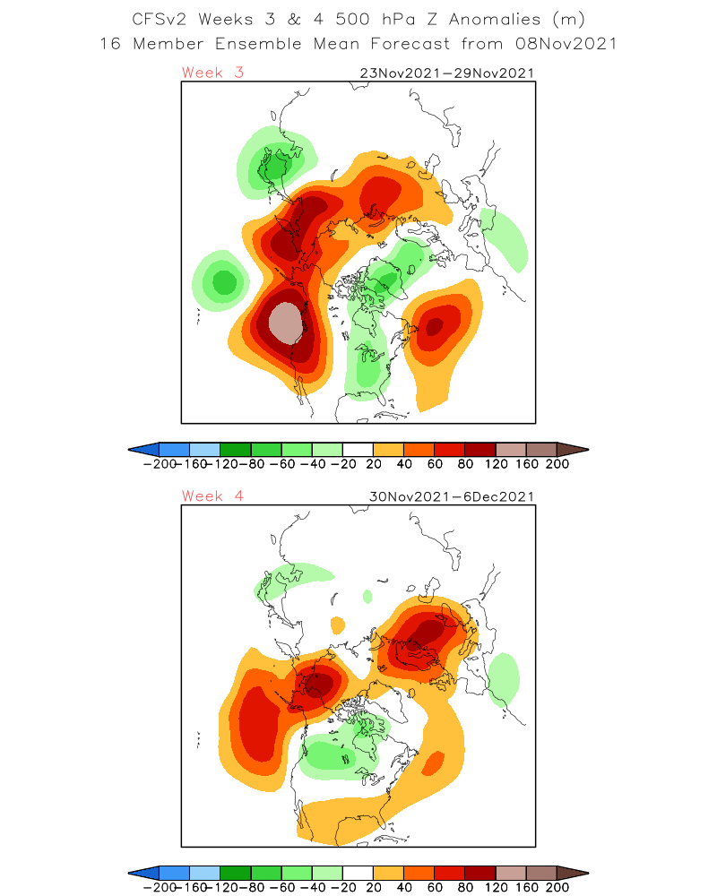
The week 4 map has the WPO block little bit west of ideal, but given the time frame, it’s prob fine for now. You shift that a touch East and we’re in business for December.
Also, Atlantic doesn’t look terrible...get that a little more blocky and we’d have more wiggle room.
And goes without saying...things could shift in a less favorable direction too. But most of the guidance is definitely going with the theme of dumping some frigid air into Canada...CFSv2 likes it too...has the higher heights up north further east which is what we’d want.
Yup - shift everything 200 nmi east and we’re good. Also would help to have a 50/50 low to lock in cold air. But maybe that doesn’t normally show up yet anyway. Any correlations that anyone has noticed between 50/50 lows and ENSO state?
. -
I actually just looked up Hingham and it makes a little more sense. I don't know why I thought that was near KBED or Framingham and it most definitely is not. Coastal south shore town (as I'm sure all of you are aware, ha)... so now it fits a little more. But still, that's a rough stretch even on the water I'd think. But I think in my head I rush climo a bit along the actual coast/Atlantic ocean early season. Plowable/decent December storms are probably a little more rare there than say BED, right?
Hingham also has a orientation issue - it’s on an east-west oriented stretch with water to the north. So even a NNE or N wind, which would give most everybody else a shot at holding on to some cold, has too much overwater fetch to make it work. Granted, it’s mainly just Boston Harbor we’re talking about, but especially early in the season, it mixed in too much heat content at lower levels.
. -
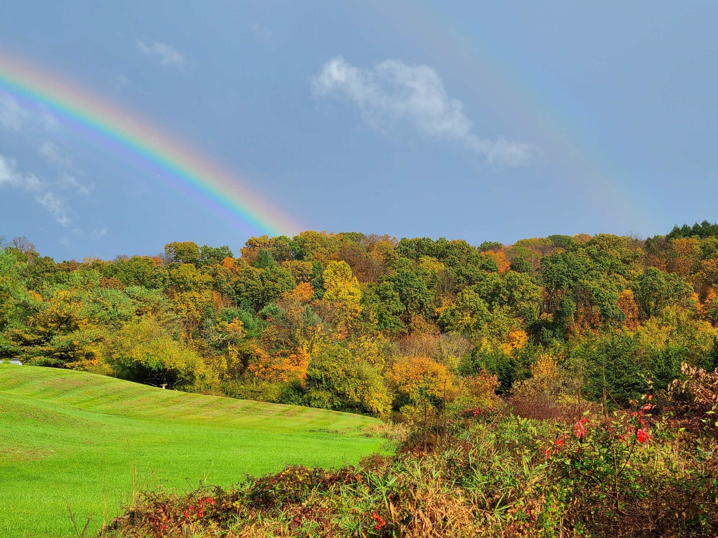
It was for like 15 minutes....it ended up a double too, I have never seen a rainbow so vivid, must have been the time of day
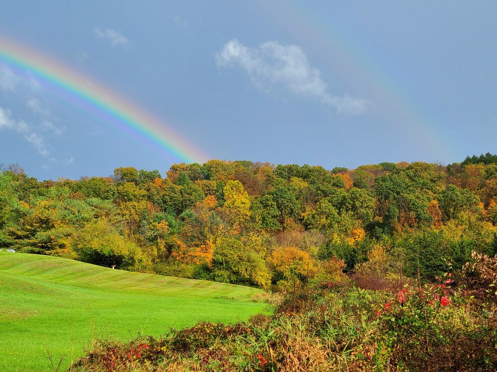
The time of year too - this time of year the sun is always below the maximum 42 degrees elevation, so the rainbow is visible all day. The farther away from noon it is, the more rainbow is visible.
.-
3
-
1
-
 1
1
-
 1
1
-
 1
1
-
-
3 hours ago, snowman19 said:
What are the potential effects of a high solar flux given the current background states? I really haven’t read too much into the solar aspects
We're still temporally near the minimum of the cycle even though getting some active sunspots. I think we're still good even with the recent spike given the historically low background state of this cycle. Also, the low but ascending part of the cycle generally seems to do better than the descending part anyways (unless you're near the 11-year peak)
-
3 minutes ago, weathafella said:
But if you see very windy conditions right off the deck wouldn’t heavy rain have a better chance of mixing that down?
Simple momentum transfer from the falling rain would make one think so.
-
42 minutes ago, SJonesWX said:
yeah that worked out great in Oct 2011

I had read something, years ago, that suggested that...anthropomorphizing as it may be, the atmosphere has to "learn" how to storm after long periods with no synoptic storms (e.g. summer). That once it had done it one time, something in the atmosphere had "learned" something and was primed to do it more easily the next time. Tip, any thoughts?
-
10 minutes ago, Typhoon Tip said:
I still am enamored some by the gesture of a coastal storm at all, really. - I mean ones of such formulaic structures in autumns - per my own experience - seemed to have "meant" well for events deeper into the year.
Still ( and admittedly ..), it is hard to get a bead on whether this is that kind of foretell, or if it is just a part of the seasonal fore -lapse, -NAO's we've been seeing more of in recent autumns.
 So...we do it again a week from Sunday?
-
1
-
-
6 minutes ago, 40/70 Benchmark said:
It can be, but not necessarily.....regardless, its nice to see the warm/dry pattern relenting to something more seasonable as the cold season begins.
Let's at least hope for upwelling as this thing passes by...at the very least, removal of upper ocean heat content so maybe won't be as quick to turn to rain at the coast.
-
Happy First GFS Clown Storm of 2022-22
.-
1
-
-
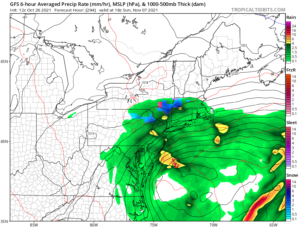
If you look at the forecasts for the North Pacific, the next big Kamchatka low around 10/27 is forecast to move/obliterate the recent very persistent North Pacific high placement. That would translate using the Bering Sea Rule to a big pattern change for the US around 11/13-11/17. My analogs had a big pattern flip ~11/15 when I did my winter outlook. I'm inclined to believe the the 10/27 low off Kamchatka is real, as is the following change in the North Pacific. But it's obviously speculative until we get closer.
GFS shows it…complete with fantasy cane at the same time.
. -
1 hour ago, CoastalWx said:
Man what a stretch coming up. Hopefully Stein comes Monday like the euro Op has.
Nice cold pool developing in GoA. Just like 2011
-
58 minutes ago, JC-CT said:
But what if it was!
Snowfall associated with a tropical system actually occurred in NE in 1804 (New England Snow Hurricane) and 1963 (Hurricane Ginny)
-
33 minutes ago, CoastalWx said:
70+ dews can go into September. I am referring to the pattern of troughs coming in and not necessarily prolonged swamp conditions. After this week....well maybe more like early next week...it looks to change. It doesn't mean we can't get hot and humid. We probably will have those conditions come and go in September.
September is what used to be called "rebound days" at my college in VT
-
That Central Park concert about to get wet.
. -
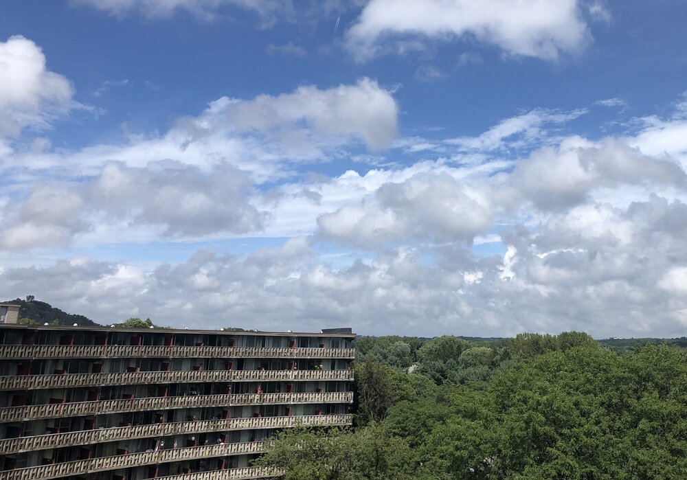
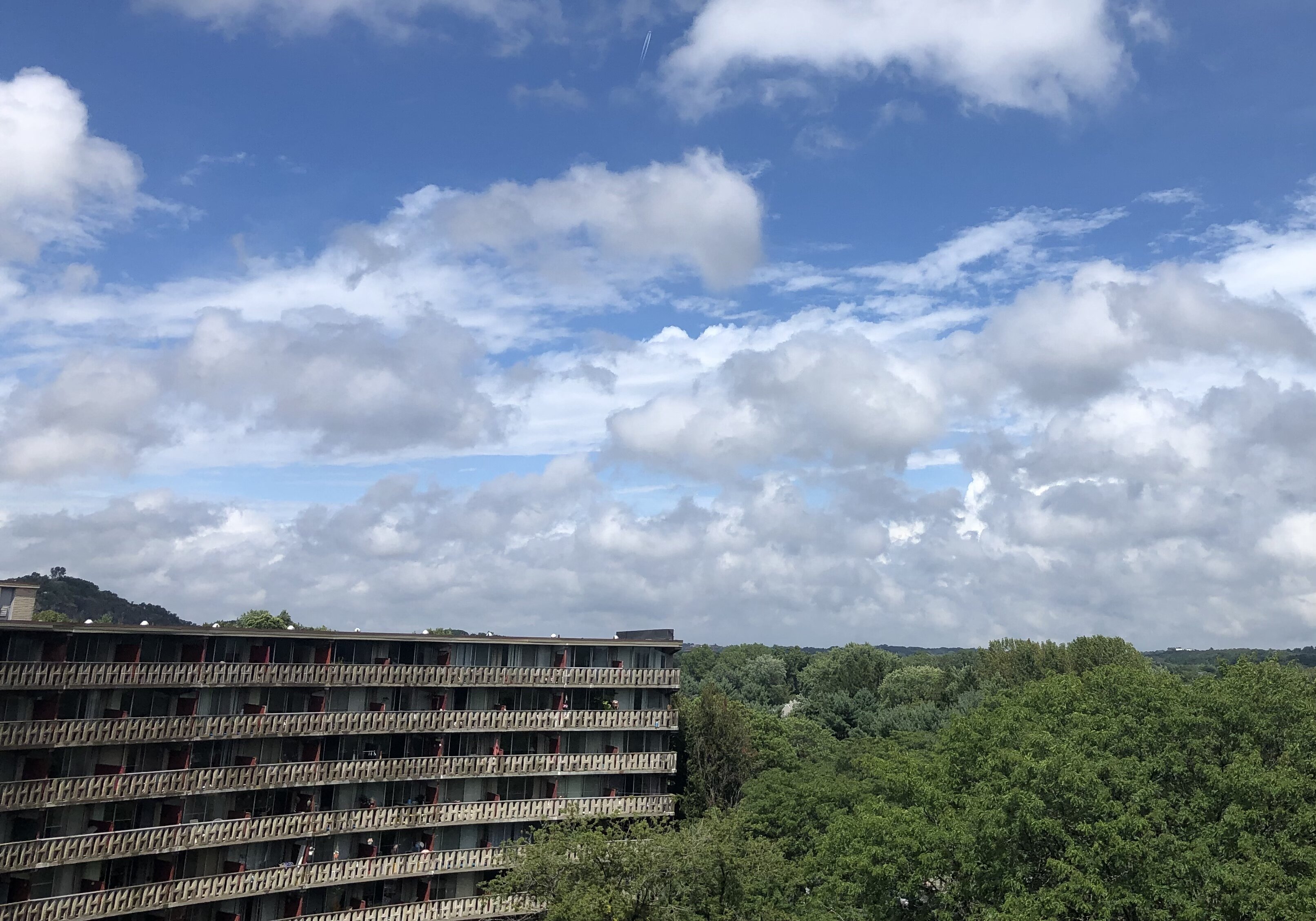
27 minutes ago, SJonesWX said:
what's that structure? looks like an abandoned radar site in Chernobyl
My condo building in Winchester, MA. Top floor, great view to NE
-
Meanwhile, gotta love this Bermuda Blue…
-
2
-
-
From 3:45 pm BOX AFD...
Temperatures will be only slightly
above normal, with highs generally in the low to mid 80s.
Should be good weather for most summer outdoor activities
(boating/swimming/boonie-stomps).
????
-
1
-
-
Somebody go out and sample the rain later, see if there's any soot in it...
-
Off tobic, but...anybody catch that warm-core system near Bermuda end of next week? Way too early to talk TCs but still...
-
2
-
Overunning Mixed Event 12/18-12/19/21
in New England
Posted
So when does he start predicting a Venus climate here?