Jns2183
-
Posts
5,851 -
Joined
-
Last visited
Content Type
Profiles
Blogs
Forums
American Weather
Media Demo
Store
Gallery
Everything posted by Jns2183
-
Central PA Spring 2026 Discussion/Obs Thread
Jns2183 replied to Voyager's topic in Upstate New York/Pennsylvania
If I were you I'd take a deep dive into station history metadata if your using raw values. One of the biggest issue I found was time of observation bias for temperature. Easily can throw things off 1-2 degres Sent from my SM-S731U using Tapatalk -
Central PA Spring 2026 Discussion/Obs Thread
Jns2183 replied to Voyager's topic in Upstate New York/Pennsylvania
It was just a few years ago we had graupel and laural summit had 11.8" of snow close to now Sent from my SM-S731U using Tapatalk -
Central PA Spring 2026 Discussion/Obs Thread
Jns2183 replied to Voyager's topic in Upstate New York/Pennsylvania
The question this summer is will we get any tropical influence or be shut out once more. I think we've had one storm in the past 4-5 years influence us with is far below normal Sent from my SM-S731U using Tapatalk -
Central PA Spring 2026 Discussion/Obs Thread
Jns2183 replied to Voyager's topic in Upstate New York/Pennsylvania
Very rarely do they last more than 48 hours Sent from my SM-S731U using Tapatalk -
Central PA Spring 2026 Discussion/Obs Thread
Jns2183 replied to Voyager's topic in Upstate New York/Pennsylvania
Thursday with highs in the upper 50's seems like the last chilly day until fall. Maybe we can sneak in a few backdoor fronts in June and have a couple relief days of drizzle. Sent from my SM-S731U using Tapatalk -
Central PA Spring 2026 Discussion/Obs Thread
Jns2183 replied to Voyager's topic in Upstate New York/Pennsylvania
The one day in July I was stuck in Houston because storms cancelled my flight made me amazed anything ever was built down there. I never had so many big bites. Sent from my SM-S731U using Tapatalk -
Central PA Spring 2026 Discussion/Obs Thread
Jns2183 replied to Voyager's topic in Upstate New York/Pennsylvania
I've been reading up on some old time weather events around this area. Anyone know where I can get some more information regarding the August 22, 1915 Hanover tornado? Seems like it was probably part of line, and was more likely than not high end EF-2/low end EF-3 that went straight through downtown. Apparently gloves from the glove factory were found many many miles away. I pulled up the reanalysis maps and it was definitely a high shear low cape. Seemed like Harrisburg area got firehosed picking up 4"-5" of rain Sent from my SM-S731U using Tapatalk -
Central PA Spring 2026 Discussion/Obs Thread
Jns2183 replied to Voyager's topic in Upstate New York/Pennsylvania
Where are you going? My parents went on a 10 day cruise there last year. Absolutely loved it besides the trains, planes, and automobiles like trip up there. They did say it was pretty cool to watch a helicopter deliver the luggage to the ship, as the diaster getting there affected numerous people. Sent from my SM-S731U using Tapatalk -
Central PA Spring 2026 Discussion/Obs Thread
Jns2183 replied to Voyager's topic in Upstate New York/Pennsylvania
Haha, also where do you get the idea they just forget to update the maps? You should take 30 mins and read up on the criteria of how the make the map. It isn't voodoo magic whose encantstions are secret knowledge. Ironically the biggest complaint against them the last few years has been their slowness to recognize drought. Not too long ago farmers in West Virginia are sending pictures in of their dead corn and craft fields when they still had supposedly a mild or moderate drought. Also I think if you would look at the areas soil types it would make more sense. Some areas are basically just run off machines because of it and it takes significantly more rain than other areas to recharge the aquifers and Wells and such. Sent from my SM-S731U using Tapatalk -
Central PA Spring 2026 Discussion/Obs Thread
Jns2183 replied to Voyager's topic in Upstate New York/Pennsylvania
We also have had 3 straight years below normal rainfall with mean deficit of 10%. Nothing has been able to recharge and the antecedent dry background condition amplifies a single dry month significantly Sent from my SM-S731U using Tapatalk -
Central PA Spring 2026 Discussion/Obs Thread
Jns2183 replied to Voyager's topic in Upstate New York/Pennsylvania
I think a big part of this is where you are located. There is a world of difference between what I'm tracking in Lancaster vs Adams county over the last 90 days soil moisture wise. One is not even -0.5 std dev below normal while the other is flying to -1.5 fast. Here are the precipitation departure from normal over some time periods Sent from my SM-S731U using Tapatalk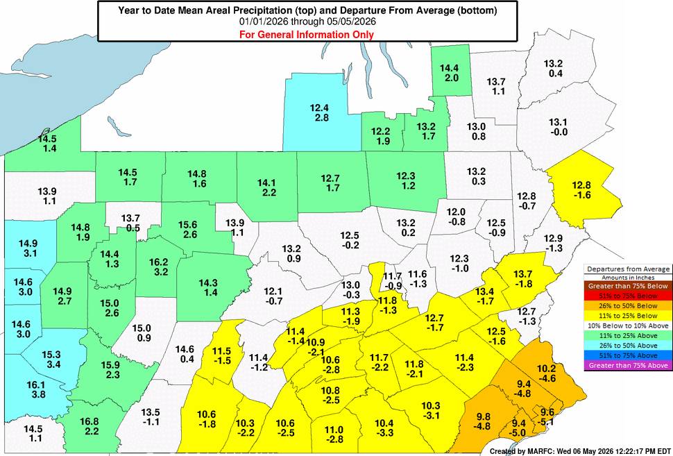
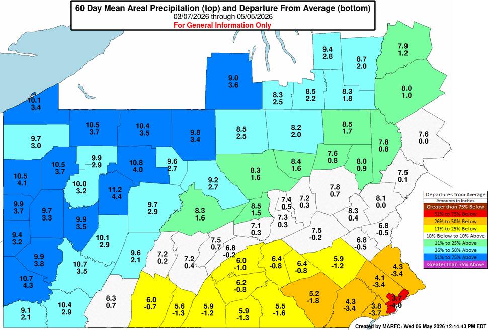
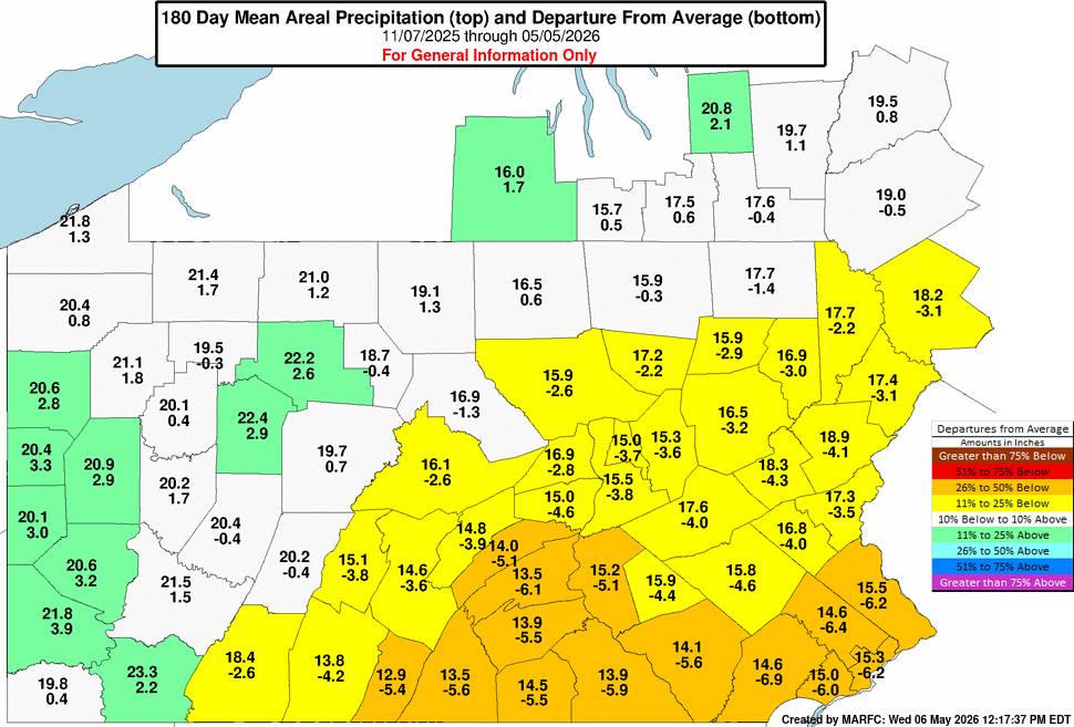
.jpg.899f2dde50b7a66b12858657d303cc56.jpg)
-
Central PA Spring 2026 Discussion/Obs Thread
Jns2183 replied to Voyager's topic in Upstate New York/Pennsylvania
Imagine you wake up one morning and patent the following revolutionary process: you walk to your mailbox, open it, read the letters inside, and then tell your spouse whether the bills are good or bad. Congratulations, you are now the sole licensed operator of checking mail. Every postal worker, every homeowner, every apartment dweller now owes you a royalty check for the cognitive crime of retrieving and interpreting written correspondence. This is essentially what Athenium LLC ( a troll of all trolls) did with US Patent 11,644,597, except instead of mail they used three freely available government weather databases that your tax dollars already paid for, applied math so simple it would embarrass a middle schooler, and then had the audacity to claim they invented "ice storm risk scoring", a thing meteorologists have been doing since before most of Athenium's employees were born. The United States Patent and Trademark Office, in its infinite wisdom, looked at this and said "yes, this is a novel human achievement worthy of 20 years of legal protection," which says everything you need to know about why your insurance premiums keep going up. Approved in 2023 and I'm at a loss at how exactly a patent inspector can reach heights of such incompetence that I found 7 instances of the exact workflow patented in research papers well before they applied for this and it took me 36 minutes exactly. I wish I could force a conflict with the NWS and them but all they want is to try to sue insurance companies and their entire worth to humanity is less than a mosquito in the Amazon. https://patents.google.com/patent/US11644597B2/en?q=(G01W1%2f14+-+Rainfall+or+precipitation+gauges)&q=(G01W1%2f10) Sent from my SM-S731U using Tapatalk
-
Central PA Spring 2026 Discussion/Obs Thread
Jns2183 replied to Voyager's topic in Upstate New York/Pennsylvania
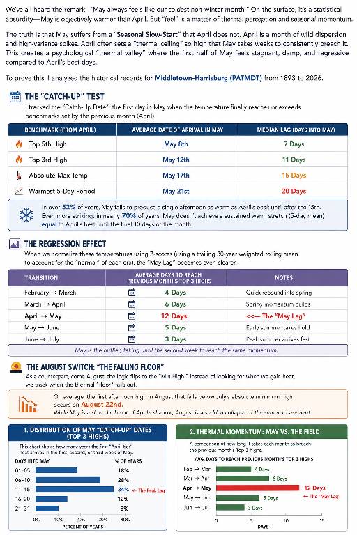
This comment was a gold mine to explore We’ve all heard the remark: “May always feels like our coldest non-winter month.” On the surface, that sounds statistically absurd. May is objectively warmer than April by the monthly averages. But “feel” is not just a raw average. It is thermal perception, seasonal expectation, and momentum. April is chaotic: a month of high variance, sharp warm spikes, and sudden spring previews. May, by contrast, often starts by lagging behind the psychological benchmark April just created. That is the core of the Seasonal Slow-Start. April frequently sets a thermal ceiling so high that May takes days, and sometimes weeks, to consistently breach it. Using historical records for Middletown-Harrisburg (PATMDT), 1893–2026, I tracked the first date in May when temperatures reached or exceeded several April benchmarks. The result is the “Catch-Up Date.” In over 52% of years, May does not produce a single afternoon as warm as April’s peak until after May 15. Even more striking, in nearly 70% of years, May does not produce a sustained five-day warm stretch equal to April’s best until the final ten days of the month. This is why early May can feel so weirdly disappointing. The month is warmer on paper, but it often opens beneath the emotional standard April already set. When the data is normalized using era-adjusted Z-scores based on a trailing 30-year weighted rolling mean, the effect becomes clearer: after a very warm April, early May can register as a real regression. Compared with other spring and early-summer transitions, May is the outlier. March usually catches February’s top warmth quickly, June catches May quickly, and July catches June almost immediately. But May takes until the second week, on average, to catch April’s top-three warmth. That delay is the statistical footprint of the “cold May” feeling. Sent from my SM-S731U using Tapatalk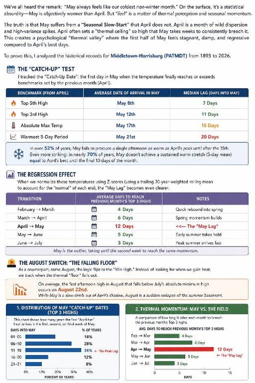
-
Central PA Spring 2026 Discussion/Obs Thread
Jns2183 replied to Voyager's topic in Upstate New York/Pennsylvania
I think we forgot the essence of spring The idea that a "normal" April day in the Susquehanna Valley is a comfortable 65/45 split is more of a mathematical ghost than a daily reality. A 30-year rolling window analysis of Harrisburg-Middletown records from 1995 to 2024 reveals that April is less of a steady seasonal climb and more of a chaotic tug-of-war between competing air masses. While 65°F is indeed the mid-month mean, the standard deviation is a staggering 10.5°F—nearly double the volatility seen in the summer months—meaning the "average" is rarely the actual experience. The statistical distribution for April proves this "battle of extremes." In a stable month like July, about 61% of days fall within 5 degrees of the daily normal. In April, that frequency drops to just 35%. Instead of temperatures clustering around the mean in a standard bell curve, the data shows a flattened, high-dispersion pattern. We are far more likely to be swung into a late-winter cold snap or an early-summer heat spike than to sit at the theoretical average. By the time May arrives, the atmosphere begins to settle, with the standard deviation tightening and about 41% of days staying near the mean. April, however, remains the ultimate transitional wildcard. The "normal" day exists on paper, but the month is defined by its swings rather than its stats. If you're planning for a 65-degree afternoon, you're betting on the narrow middle ground of a month that statistically prefers to live in the extremes. [mention=317]Voyager[/mention] your wish on consistency in April is basically a fig dream. That's just not the reality that exists in Pennsylvania. Consistency is for June, July, August Sent from my SM-S731U using Tapatalk -
Central PA Spring 2026 Discussion/Obs Thread
Jns2183 replied to Voyager's topic in Upstate New York/Pennsylvania
It's a lot more than rain goes into that. You have to look at absorption vs run off vs evapotranspiration. We have baked all April. I only got about 55% of normal preceiptitation. Go look at the PEMN sites on pa climate website. They have soil moisture at 3-5 different depths. That really tells the story. This super El nino building is not good either Sent from my SM-S731U using Tapatalk -
Central PA Spring 2026 Discussion/Obs Thread
Jns2183 replied to Voyager's topic in Upstate New York/Pennsylvania
Hopefully they are properly hedged and insured. However, I'm sure those costs are through the roof Sent from my SM-S731U using Tapatalk -
Central PA Spring 2026 Discussion/Obs Thread
Jns2183 replied to Voyager's topic in Upstate New York/Pennsylvania
.82" which puts me at 2.42' for month. Just over 50%[emoji769] of normal. We are not in good shape if we don't get a top 20 wet May. Sent from my SM-S731U using Tapatalk -
Central PA Spring 2026 Discussion/Obs Thread
Jns2183 replied to Voyager's topic in Upstate New York/Pennsylvania
I'm really sorry to hear this. That cold February followed by March warmth followed by April 8th freeze then hyper Summer before the 2.6-3std deviation freeze on 21st was the perfect trap. Sent from my SM-S731U using Tapatalk -
Central PA Spring 2026 Discussion/Obs Thread
Jns2183 replied to Voyager's topic in Upstate New York/Pennsylvania
A little thought experiment. What do you feel is the worst case meterological scenario rack the lower Susquehanna valley has a realistic chance of facing the rest of this century. Something that doesn't get talked about enough for this area is the setup that truly keeps me up at night. It's a deep Greenland block anchoring a stationary front right along the spine of the mountains to our west, timed perfectly with a tropical system on approach. The PRE (the days before lee featured a pre, and it wouldn't have taken that much different timing for hurricane Katia which fed the pre, to be this storm) Days two and three before landfall, small shortwaves combined with a tropical depression remnant riding up over a stalled front to our West in the mountains due to a strong, south based, slowly retreating rex block, low level moisture from our hurricane start training over the same geography repeatedly. Due to the angle of approach the moisture tap is already running full blast hundreds of miles ahead of the center. We're talking three to eight inches of rain before the storm even gets close. Ground is done. Fully saturated. Soil is weakened around every root plate in the metro. Then the approach angle shifts. Forward speed jumps from maybe ten to thirty mph as the block partially erodes and the storm finds its exit. The damage from that sequence is already locked in before a single tropical wind gust arrives. Now put the track just west of the valley so we're sitting in the right front quadrant, winds from the southeast, additive component of forward motion stacked on top of rotation. Even if the winds only land somewhere between Hazel and Sandy that's a catastrophic tree loss event on a seventy year old suburban canopy that has never been tested. The part nobody plans for is the utilities. Crews are staged south for whatever hit the coast first. Forecast uncertainty from the block interaction blew the seventy two hour window you need to pre-position resources here. The SSE wind vector exposes trees weakest side to worst winds. Many of the roads 5-10 minutes from camp hill basically have a tree canopy for miles due to how thick and close the trees grow. Those roads become impassable with 20+ trees blocking it per mile in heavy forest. All those railroads like that taking away from two to four weeks actually become open We get weeks without power in a lot of places, not days. The situation in rural areas is more similar to Helene and Katrina with being cut off. This is one where overall emergency managers can make the correct statistical rational choice and because of timing and non linearity it still becomes a disaster like none other. The same setup that sends the the cat 4 at landfall hurricane rocketing up here at 30-50 mph (hazel which saw 98mph at DC and close to it in York was only going 30mph while the 38' hurricane through Long Island was at 55mph and that Forwardvmotion gets added to the winds on the east side) is the one that stalls the front, pierce the low-level tropical moisture into it causing the pre. So that is it. My crazier 1 in 10,000 year scenario for it even happening on the east coast period involves an upper Midwest drought not unlike the one preceding the 1871 Pestigo firestorm, a potent shortwave from that direction that perfectly hits a window of just an hour or two to cause the rapidly coming storm to occlude in a manner that produces a stinger jet like the 1987 storm that hit the Uk. A small area the size of the lsv on the south to ssw flank would be in overlap area due to shape of Appalachian mountains and track. The stinger jet would produce gusts over 125+ with sustained over 85. That area would of overlap with insane tornado parameters that in the perfect situation would give us (early October) cape above 2200, SRH 450+ with 135 degree turning between 850 and 500mb. STP estimated at 8+ easy, LCL 250-500 meters. The model producing these values went ape shit especially due to dry air from upper Midwest. It's one of those things that's possible but so far unlikely that planning is fruitless. That 1 in 10,000 year event was just the pieces coming together like this. You can't even. Calculate a return period for alot if areas due to Continental drift and long term climate. But hey, if your area manages to get a stinger jet and ef4 tornados from the same system I'd bet the on the Apocalypse happening before I would bet on being random weather. Sent from my SM-S731U using Tapatalk -
Central PA Spring 2026 Discussion/Obs Thread
Jns2183 replied to Voyager's topic in Upstate New York/Pennsylvania
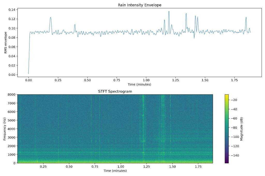
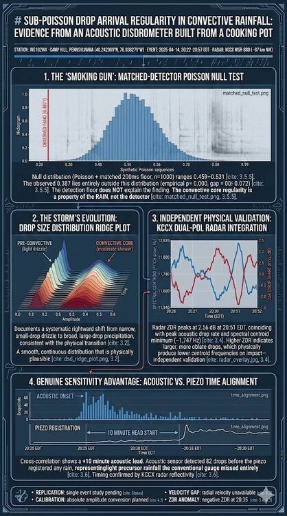
My daughter's science project we picked was recording the sound of rain underneath a pot on a deck. She got an A and I've had way to much fun since with the data. Sent from my SM-S731U using Tapatalk
-
Central PA Spring 2026 Discussion/Obs Thread
Jns2183 replied to Voyager's topic in Upstate New York/Pennsylvania
Does anyone have any experience with using QGIS here? Particularly importing LIDAR maps the government made to build a horizon analysis that look at heights of the land and of the vegetation/forest on it? If you have experience with any of the mentioned items above, especially a good tutorial for QGIS I would appreciate it. That software is kicking my ass. Sent from my SM-S731U using Tapatalk -
Central PA Spring 2026 Discussion/Obs Thread
Jns2183 replied to Voyager's topic in Upstate New York/Pennsylvania
.42" here. The soil moisture levels needed this Sent from my SM-S731U using Tapatalk -
Central PA Spring 2026 Discussion/Obs Thread
Jns2183 replied to Voyager's topic in Upstate New York/Pennsylvania
We've had such an above normal april that when comparing to other years like it when stands out is that may tends to be below normal in almost every case. Also the kinda of rain we need, slow soaking, long duration, usually comes with cut of lows, east winds and temperatures in the 60's during June and 50's during May Sent from my SM-S731U using Tapatalk -
Central PA Spring 2026 Discussion/Obs Thread
Jns2183 replied to Voyager's topic in Upstate New York/Pennsylvania
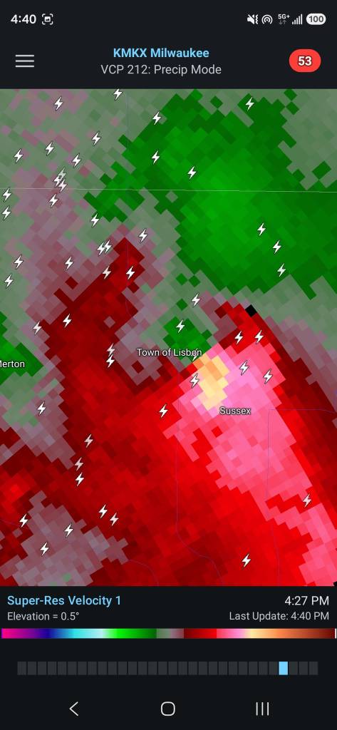
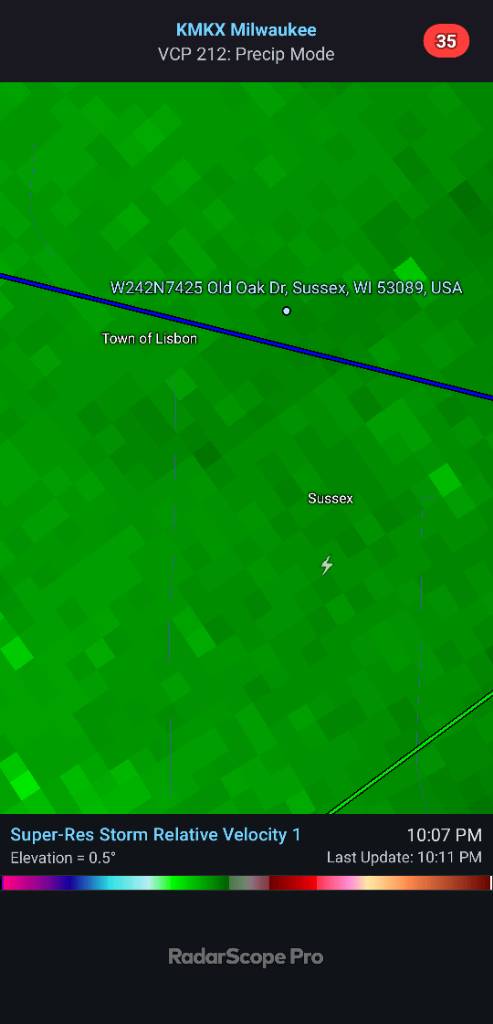
My dad had one hit his neighborhood. He has no power or Internet and he hears the chainsaw going. Right up means about 1,200 ft there and that looks like about 100 knots g2g at peak Sent from my SM-S731U using Tapatalk
-
Central PA Spring 2026 Discussion/Obs Thread
Jns2183 replied to Voyager's topic in Upstate New York/Pennsylvania
I think this year we see some action. In May. Although with these temperatures that may get pushed to April. Sent from my SM-S731U using Tapatalk