Jns2183
-
Posts
5,838 -
Joined
-
Last visited
Content Type
Profiles
Blogs
Forums
American Weather
Media Demo
Store
Gallery
Everything posted by Jns2183
-
Central PA Fall Discussions and Obs
Jns2183 replied to ChescoWx's topic in Upstate New York/Pennsylvania
It's a hiking trail in the woods. I'd need more snow to make raw dogging it up and over a mountain by compass and moonlight to be worth it Sent from my SM-S731U using Tapatalk -
Central PA Fall Discussions and Obs
Jns2183 replied to ChescoWx's topic in Upstate New York/Pennsylvania
I'm soon going on a 3 hour night hike under full moon and snow. This is heaven Sent from my SM-S731U using Tapatalk -
Central PA Fall Discussions and Obs
Jns2183 replied to ChescoWx's topic in Upstate New York/Pennsylvania
How do you lose money Sent from my SM-S731U using Tapatalk -
Central PA Fall Discussions and Obs
Jns2183 replied to ChescoWx's topic in Upstate New York/Pennsylvania
It will take smith with a $30-$50 million yearly commitment to save us Sent from my SM-S731U using Tapatalk -
Central PA Fall Discussions and Obs
Jns2183 replied to ChescoWx's topic in Upstate New York/Pennsylvania
We need to do whatever pegula wants cause he is the only one with the money to save us Sent from my SM-S731U using Tapatalk -
Central PA Fall Discussions and Obs
Jns2183 replied to ChescoWx's topic in Upstate New York/Pennsylvania
Haha, popular because they got rid of the plague? Sent from my SM-S731U using Tapatalk -
Central PA Fall Discussions and Obs
Jns2183 replied to ChescoWx's topic in Upstate New York/Pennsylvania
Maybe this is the needed sacrifice for mother nature to finally open her legs Sent from my SM-S731U using Tapatalk -
Central PA Fall Discussions and Obs
Jns2183 replied to ChescoWx's topic in Upstate New York/Pennsylvania
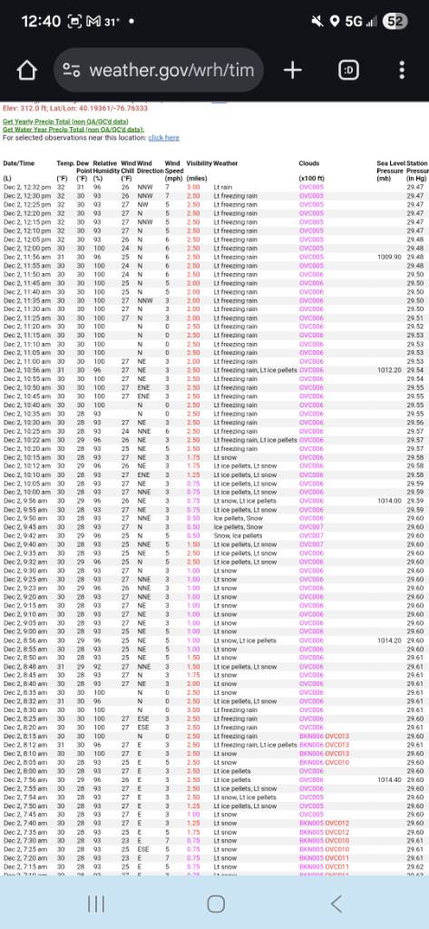
This says freezing rain for most of the storm Sent from my SM-S731U using Tapatalk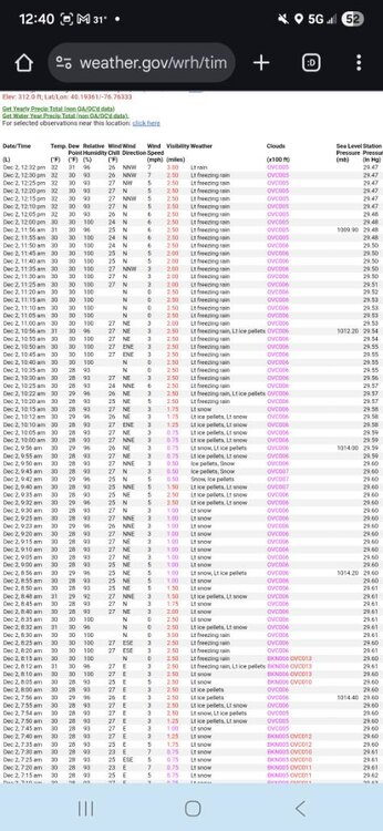
-
Central PA Fall Discussions and Obs
Jns2183 replied to ChescoWx's topic in Upstate New York/Pennsylvania
In a way I am over sports gambling. I just absolutely despise all talking heads and opinion people on everything so polymarket at least gives me some semblance of information and helps me avoid the people I abhor. Sent from my SM-S731U using Tapatalk -
Central PA Fall Discussions and Obs
Jns2183 replied to ChescoWx's topic in Upstate New York/Pennsylvania
The markets have it a neck and neck race between Jeff Brohm and Terry Smith Sent from my SM-S731U using Tapatalk -
Central PA Fall Discussions and Obs
Jns2183 replied to ChescoWx's topic in Upstate New York/Pennsylvania
That did shovel like lead Sent from my SM-S731U using Tapatalk -
Central PA Fall Discussions and Obs
Jns2183 replied to ChescoWx's topic in Upstate New York/Pennsylvania
They need to roll the dice and hire hartline Sent from my SM-S731U using Tapatalk -
Central PA Fall Discussions and Obs
Jns2183 replied to ChescoWx's topic in Upstate New York/Pennsylvania
If Smith gets the job we lose a ton of NIL money. I know that for a fact based on some donors I know through work. Sent from my SM-S731U using Tapatalk -
Central PA Fall Discussions and Obs
Jns2183 replied to ChescoWx's topic in Upstate New York/Pennsylvania
I think with this storm like many past ones 10-15 miles was the difference between contentment and despair. Due to the thermal gradiant and proximity to Atlantic it just happens that a large population lives in these areas. The geography and climatology dictate these will continue to be the battle areas during our lives and more and more people will be living on the edge. Sent from my SM-S731U using Tapatalk -
Central PA Fall Discussions and Obs
Jns2183 replied to ChescoWx's topic in Upstate New York/Pennsylvania
Probably not much judging by their observations Sent from my SM-S731U using Tapatalk
-
Central PA Fall Discussions and Obs
Jns2183 replied to ChescoWx's topic in Upstate New York/Pennsylvania
Friday it may not get above 30 Sent from my SM-S731U using Tapatalk -
Central PA Fall Discussions and Obs
Jns2183 replied to ChescoWx's topic in Upstate New York/Pennsylvania
I can see 6" Sent from my SM-S731U using Tapatalk -
Central PA Fall Discussions and Obs
Jns2183 replied to ChescoWx's topic in Upstate New York/Pennsylvania
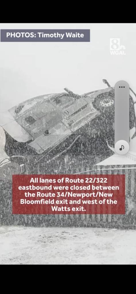
Truck hauling ice cream has shut down 322/22 Sent from my SM-S731U using Tapatalk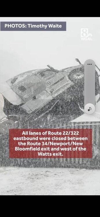
-
Central PA Fall Discussions and Obs
Jns2183 replied to ChescoWx's topic in Upstate New York/Pennsylvania
That man dislikes snow like @Voyager dislikes an ice storm when he's driving Sent from my SM-S731U using Tapatalk -
Central PA Fall Discussions and Obs
Jns2183 replied to ChescoWx's topic in Upstate New York/Pennsylvania
Finished with 3.75". Sent from my SM-S731U using Tapatalk -
Central PA Fall Discussions and Obs
Jns2183 replied to ChescoWx's topic in Upstate New York/Pennsylvania
It appears as little as 5 miles separates drastically different conditions in some areas. I love how people just love to complain and if you point out conditions maybe different in a different place they have no problem telling you that the only place that truly and rightly matters is the one they are at. Sent from my SM-S731U using Tapatalk -
Central PA Fall Discussions and Obs
Jns2183 replied to ChescoWx's topic in Upstate New York/Pennsylvania
Just 60lbs of weights in my backpack for a 5K jaunt. I have a 24 hour / 36 mile hike on some difficult trails in the Poconos planned this February with my Brother. Sent from my SM-S731U using Tapatalk -
Central PA Fall Discussions and Obs
Jns2183 replied to ChescoWx's topic in Upstate New York/Pennsylvania
Sitting in front of fire, cold and wet Sent from my SM-S731U using Tapatalk -
Central PA Fall Discussions and Obs
Jns2183 replied to ChescoWx's topic in Upstate New York/Pennsylvania
Freezing rain. Was just out in it hiking the past hour. It's 30 here Sent from my SM-S731U using Tapatalk -
Central PA Fall Discussions and Obs
Jns2183 replied to ChescoWx's topic in Upstate New York/Pennsylvania
I've got 3" Sent from my SM-S731U using Tapatalk