

OceanStWx
-
Posts
19,758 -
Joined
-
Last visited
Content Type
Profiles
Blogs
Forums
American Weather
Media Demo
Store
Gallery
Everything posted by OceanStWx
-
"Nearly continuous" Meaning it wasn't continuous. The story I've heard is that all the trees were mainly down to the NE or E, with a few to the NW. So in my opinion, either it was a tornado where the few to the NW were, OR this was straight line wind with a few randomly tossed trees based on local factors of tree weaknesses, etc. I mean it's all possible. The environment was fair for QLCS tornadoes, mainly west of NH, so it's not crazy that one happened. But 35 mile long one? Of course the beam is 11,000 ft above radar level near the CT River (about 9,000 ft from ENX) and still over 7,000 ft in Merrimack Co. These types of tornadoes are unlikely to be very deep mesos, but a long track one certainly would be (a la NH 2008).
-
All I can see from the radar data, is a broken S signature. But I'm not sure I would ever warn on the velocity couplet there.
-
No. They note part of it was inaccessible. Yes.
-
And if it is a 35 mile long tornado, there should be no BS "a more detailed PNS will be issued Tuesday." Someone should be on that ASAP.
-
I just downloaded the radar data, but I'll go to my grave not believing this is a 35 mile long tornado.
-
I call BS. I was warning operator that day, and I can buy a tornado near the CT River. The beam is like 7-8 kft there, easy to miss a low level QLCS tornado. But a 36 mile (4th-ish longest New England tornado), I don't think so. My guess (hope?) is that WMUR confused a statement about the length of thunderstorm wind damage with the smaller tornado path.
-
Well that's the thing. The EML has plenty of dry air, so if you can have some mechanism to suppress clouds (like subby) it should clear out. But if you keep weak height falls or something like that the low level moisture can just percolate at the bottom of that layer. All models have those subtle height rises tomorrow morning.
-
The key for parts of WNE is how much clearing we get in the wake of the morning shortwave. The NAM does have subtle height rises and subsidence following it, so that could suppress cloud cover and provide some insolation.
-
Reporting RAPL. I think they mean RAGR
-
GFL 53 knots. Not bad.
-
That is really surging out and bowing now along 91 (viewed from GYX).
-
42 knots measured at MVL, not too bad for an automated site.
-
Those winds are right on the reflectivity gradient. That should rip pretty good.
-
MRMS had like a 0.022 shear value there near Jay. That's definitely in the range of tornadic.
-
MWN should rip in a couple hours. CXX sampling 90 knots at 4 kft. It is roaring just off the deck behind that line.
-
Nasty storm going through Franklin County, VT. Big BWER on it, but CXX can't see the low level rotation at all.
-
Sampling 70 knots at 230 feet. That cell had some serious echo overhang to it.
-
Locally, I'm ready to knock down the corners of a few dog legs.
-
Yeah, north side of bowing segments is going to be the place to watch (like near RME right now). That puts the focus through VT, as the tail end of the line is lagging through the Southern Tier at the moment.
-
The forcing is starting to hit that reservoir of steep low level lapse rates.
-
-1 NROT with the storm in western MA. That's probably the "lowest" value I've ever seen. Considering +1 is important for tornadogenesis in New England.
-
Hodographs straighten out quite a bit above 1 km, which would support the elevated left movers. But of course still a decent tornado risk from the surface based right movers.
-
It's a nice left mover, so probably still a bit elevated.
-
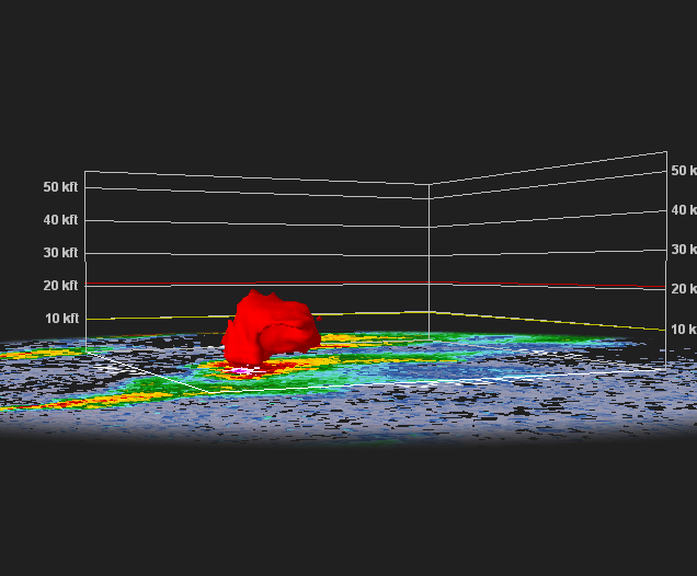
Big BWER north of Old Forge.
-
This is going to be a pain in the azz to warn on. In these high shear environments, the storm height is effectively taller than it appears on radar. When the updraft gets tilted (due to the shear) it is longer relative to its height. So when looking for a core to a certain level, these storms may not show it before they start producing severe weather.

