
paweather5
-
Posts
455 -
Joined
-
Last visited
Content Type
Profiles
Blogs
Forums
American Weather
Media Demo
Store
Gallery
Everything posted by paweather5
-
Central PA - Winter 2021/2022
paweather5 replied to Bubbler86's topic in Upstate New York/Pennsylvania
Slowly trending west each run. -
Central PA - Winter 2021/2022
paweather5 replied to Bubbler86's topic in Upstate New York/Pennsylvania
120 on the bottom 126 on top. -
Central PA - Winter 2021/2022
paweather5 replied to Bubbler86's topic in Upstate New York/Pennsylvania
Thanks to 33 and rain, last three euro runs. -
Central PA - Winter 2021/2022
paweather5 replied to Bubbler86's topic in Upstate New York/Pennsylvania
Correct this is the op run. -
Central PA - Winter 2021/2022
paweather5 replied to Bubbler86's topic in Upstate New York/Pennsylvania
euro still likes the Friday into Saturday storm. -
Central PA - Winter 2021/2022
paweather5 replied to Bubbler86's topic in Upstate New York/Pennsylvania
Wind advisory now up for gust to 50. -
Central PA - Winter 2021/2022
paweather5 replied to Bubbler86's topic in Upstate New York/Pennsylvania
Just saw a report out of Mid Atlantic thread three inches of sleet. -
Central PA - Winter 2021/2022
paweather5 replied to Bubbler86's topic in Upstate New York/Pennsylvania
Is that good or bad thing? -
Central PA - Winter 2021/2022
paweather5 replied to Bubbler86's topic in Upstate New York/Pennsylvania
-
Central PA - Winter 2021/2022
paweather5 replied to Bubbler86's topic in Upstate New York/Pennsylvania
Ukmet and cmc ugly and about the same. -
Central PA - Winter 2021/2022
paweather5 replied to Bubbler86's topic in Upstate New York/Pennsylvania
from 33 and rain little east this run. -
Central PA - Winter 2021/2022
paweather5 replied to Bubbler86's topic in Upstate New York/Pennsylvania
-
Central PA - Winter 2021/2022
paweather5 replied to Bubbler86's topic in Upstate New York/Pennsylvania
Ukmet -
Central PA - Winter 2021/2022
paweather5 replied to Bubbler86's topic in Upstate New York/Pennsylvania
-
Central PA - Winter 2021/2022
paweather5 replied to Bubbler86's topic in Upstate New York/Pennsylvania
-
Central PA - Winter 2021/2022
paweather5 replied to Bubbler86's topic in Upstate New York/Pennsylvania
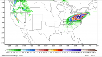
GEFS is definitely less amplified. EC heights are lower and the jet is weaker. the NS energy is also holding to the north this will be SE. from another poster on GEFS Update, good bit southeast this run. -
Central PA - Winter 2021/2022
paweather5 replied to Bubbler86's topic in Upstate New York/Pennsylvania
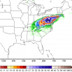
Did anyone just see the gfs storm. 30 inch storm up the coast. I use to be Able to post picture but no longer can. Everything I do it’s to big of file size. -
Central PA - Winter 2021/2022
paweather5 replied to Bubbler86's topic in Upstate New York/Pennsylvania
Can confirm just shy of 7 near ski roundtop in York. -
Central PA - Winter 2021/2022
paweather5 replied to Bubbler86's topic in Upstate New York/Pennsylvania
11 pm added another inch last hour. Just shy of 4 inches. -
Central PA - Winter 2021/2022
paweather5 replied to Bubbler86's topic in Upstate New York/Pennsylvania
I am just shy of 3 inches for my 10 PM measurement. -
Central PA - Winter 2021/2022
paweather5 replied to Bubbler86's topic in Upstate New York/Pennsylvania
CMC with a nice hit as well. -
Central PA - Winter 2021/2022
paweather5 replied to Bubbler86's topic in Upstate New York/Pennsylvania
Three days ago I came down with Covid and getting my butt kicked. I had it prior to vax and it wasn’t that bad. This time the chest pain has been unreal. Fever and chills. Not sure what strain I got but it’s brutal. I know good many people saying the same thing. I went to WellSpan for testing and the line was 50 people deep no joke. I also work in medical field and see multiple hospitals and it’s not good what they are saying. What’s scary is the amount of people I know with the vax saying it’s rocking them hard as well. -
Central PA - Winter 2021/2022
paweather5 replied to Bubbler86's topic in Upstate New York/Pennsylvania
Haha all good, I kept refreshing thinking it wasn’t loading correctly. Only reason I asked. -
Central PA - Winter 2021/2022
paweather5 replied to Bubbler86's topic in Upstate New York/Pennsylvania
Am I missing something? On tropical tidbits don’t even have a storm. -
Central PA - Summer 2021
paweather5 replied to Itstrainingtime's topic in Upstate New York/Pennsylvania
Looks like tornado warning in York


