

dmc76
-
Posts
6,648 -
Joined
-
Last visited
Content Type
Profiles
Blogs
Forums
American Weather
Media Demo
Store
Gallery
Posts posted by dmc76
-
-
Finally getting a solid rain event here in central west macomb. It’s been a long time. So far 0.74” just the beginning
-
 1
1
-
-
On 7/7/2020 at 12:50 AM, frostfern said:
Okay, but i's not the greatest year here either though. It's not full drought yet, but still boring as hell if you want t-storms. 2018 repeat. Have to wait until late August to get one of those good low-level jet-fueled nocturnal MCSs. On the east side of the state you at least have a shot at some afternoon storms. Here Wisconsin afternoon stuff inevitably eats shit when it hits the lake, and night stuff dies too with no low-level jet due to constant weak-ass synoptic pattern. I remember when heat waves used to have nocturnal convection. Recent times they have nothing but airmass shit that gets totally suppressed by lake-breezes.
....not even close
-
1
-
-
On 8/2/2020 at 2:47 PM, Stebo said:
Must be real localized. DTW DET had 5.00+ in July and Flint had 3.72"
I’ll put money on it that isolated areas of central/western Oakland, Western macomb around stoney creek and parts of the thumb...is the driest area(s) East of the Mississippi
-
Huge portions of SEMI is in a drought. I’ve never seen it this dry. Parts of Western Oakland county is completely cooked. Rain tonight looks minimal, again.
-
 1
1
-
-
17 hours ago, frostfern said:
Okay, but i's not the greatest year here either though. It's not full drought yet, but still boring as hell if you want t-storms. 2018 repeat. Have to wait until late August to get one of those good low-level jet-fueled nocturnal MCSs. On the east side of the state you at least have a shot at some afternoon storms. Here Wisconsin afternoon stuff inevitably eats shit when it hits the lake, and night stuff dies too with no low-level jet due to constant weak-ass synoptic pattern. I remember when heat waves used to have nocturnal convection. Recent times they have nothing but airmass shit that gets totally suppressed by lake-breezes.
What does a shot of afternoon storms have to with the west being dryer than the East?
-
5 hours ago, frostfern said:
Western Michigan is being lake shadowed to hell though. I can see it getting extremely dry if we don't get a single damn thunderstorm. These constant weak synoptic conditions with light west wind don't give any rain on this side of the lake.
Are u joking with this post? It’s the absolute opposite the east side of Michigan has had little rain in the last three months in a lot of areas. Me personally living in northern Macomb we haven’t had squat you should take a ride in northern/central Macomb everything is brown. I’m at about just under 1” of rain where I’m at since June 1
-
On 2/24/2020 at 1:36 PM, UMB WX said:
6-8" on Euro is still a Big Dog storm for, SE, MI standards.
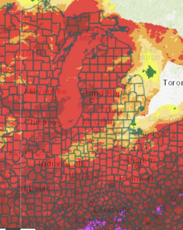
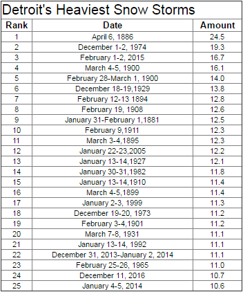
Just wanted to fill u in. Much of SEMI especially the northern burbs of Detroit did pick their 3rd 6”+ event of the season. 11.2” 7.7” and still going but it’s currently at about 6.0” with maybe another 1” or so. To go. What’s remarkable. This is the 11th 6”+ event since the winter of 17/18.
-
2
-
-
-
1 minute ago, UMB WX said:
Uh yeah.
For many decades the records were taken at city airport which is arguably one of the worst spots for snowfall in the entire state of Michigan. Now if you head west by 20 miles or north by 20 miles snowfall probably almost increases by 15 to 20 inches per season.
-
1
-
-
Just now, UMB WX said:
10 to 18? lol. More like 8-12 considering how shitty of a climo Detroit south is for big storms.
You were only talking about Detroit? No you were not. You were talking about Southeast Michigan as a whole it’s a little bit bigger than Detroit. Have you looked at the map of Southeast Michigan lately
-
Just now, snowstormcanuck said:
lol @ pouting over a snow climo jab.
Just a really poor attempt at a joke I just had to let them now.
-
1
-
1
-
-
5 hours ago, UMB WX said:
6-8" on Euro is still a Big Dog storm for, SE, MI standards.
Actually this will be the third snow storm of 6 inches or more. This is actually very routine for the northern suburbs of Detroit, extremely routine. The statement couldn’t be further from the truth. Just a really poor attempt at a joke. Now a big dog for this area is definitely 10-18 inches but we never touch 18 inches but we usually cap off at about 17 at the highest
-
3
-
-
35 minutes ago, michsnowfreak said:
So Detroit has one subpar Winter and that means hes not missing much? He missed 62" last Winter (i think he moved just before winter) and the avg this decade is like mid-50s. Even with the misses snow fell very often and there were multiple ice storms. My statement to powerball remains. He left a place where it snows all the time and goes to a place that can go a Winter without a single flake. I would not survive, he does not miss snow. We are not cut from the same cloth lol.
I’m just saying I don’t think Detroit snowfalls enough to really truly miss it. I don’t really think there’s anywhere in the southern half of lower Michigan to really miss it. Maybe around GRR
-
Just now, michsnowfreak said:
Actually i remember the exact opposite, at least here. Which was amazing. It snowed all afternoon Apr 23 into the overnight and we barely got an inch. Then heavy blinding snow hit during the late morning and early afternoon which is when most of the accumulation occurred, about 5 more inches. It then lightened in intensity by evening and though snow continued it hardly accumulated any more. Total snow here 6.7".
Of course that is the exception not the rule. Obviously for the most part nighttime is a help in spring snows.
I think it was earlier that Saturday morning when it was coming down but has the day went on it struggled to accumulate
-
3 hours ago, michsnowfreak said:
Wow lol we are definitely not cut from the same cloth haha. You've been down there 2 winters now?
There’s not really much to miss in Detroit to regards to winter. Seriously. What did he miss...31”? U r not gonna miss that. Lol
-
I remember the April 23-25 2005 snowstorm in SEMI brought upwards of 16” in Northern Oakland county (40 miles NNW of Detroit) it was a stalled out low that sat and spun for over 2 days. What I remembered is that 90% of the accumulation happened at night. During the day it rarely stuck. Moral of the story is that.... u start approaching very late April into May. Now, snow has to happened at night.
-
1
-
-
APN __ 77.0”
ORD __ 45.8”
CLE __ 82.4”
CMH __ 38.9”
DET __ 58.4”
FWA __ 47.8”
GRR __ 82.0”
GRB __ 55.6”
IND __ 28.8”
LSE __ 40.6”
YXU __ 104.4”
SDF __ 17.7”
MQT __ 189.0”
MKE __ 54.0”
MSP __ 47.7”
MLI __ 27.0”
PAH __ 21.0”
PIA __ 22.0”
STL __ 25.0”
YYZ __ 63.2”
Tiebreakers
1. December 2017 snowfall ORD (10.2”)
2. January 2018 snowfall IND (11.0”)
3. February 2018 snowfall (12.0”)
-
 1
1
-
-
I feel old now.
I was16! Im old
-
I remember that summer spent 3 months in Italy and when I came back in early September temps were in the 50's and everybody was white as a ghost.
-


November 30-December 2 *Potential* Winter Storm
in Lakes/Ohio Valley
Posted
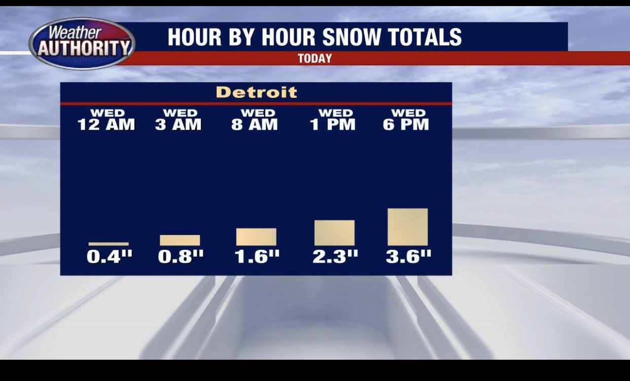
Hot hand? Whopping 0.5” so far. Lmao.