

vastateofmind
-
Posts
1,676 -
Joined
-
Last visited
Content Type
Profiles
Blogs
Forums
American Weather
Media Demo
Store
Gallery
Posts posted by vastateofmind
-
-
5 hours ago, MN Transplant said:
Dud of a weekend coming up. Dreary on Saturday and then breezy/chilly on Sunday.
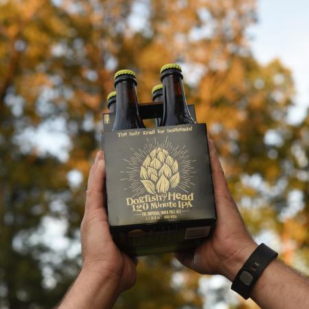
PERFECT days for working one's way through a four-pack of DFH 120 Minute IPA. Or, arguably, a 4-pack for EACH weekend day...God help me.
-
 2
2
-
 2
2
-
-
31 minutes ago, Kay said:
Anyone spot any osprey yet? I've been super busy but haven't seen or heard any so far.
Yep. I report to work at Fort Belvoir once weekly and try to do a lunchtime walk down to Accotink Bay...have seen a handful of osprey in past couple weeks, and a couple of them have already been hooting at me when I walk near their nesting platforms/poles, which the Army is pretty good about placing all around the bay for them. Of course, they're not averse to building their pterodactyl-like nests at the top of the field lights surrounding nearby baseball/softball fields on post, either.
")
-
2
-
-
8 hours ago, wxdude64 said:
Got home last night about 8 pm. Put 5500 miles on the car in 11 days (an oil change is planned for later today + a good scrubbing). Saw temps range from 70's to single digits, sun/wind/rain and snow. Overall a great trip, but boy do several states need to work on their roads!! (I'm looking at you IN and IL! Arizona gets a consolation prize for 3rd place.)
We did a circuit driving trip to the Grand Canyon late last summer and put about the same amount of miles you just quoted on our 2009 Honda Pilot (which, after that trip, currently has ~97K miles on it). I'd have to say that last summer, AZ, NM and OK had some of the worst roads we've encountered ever.
BUT...I'm not retiring that trophy yet, as we're doing another extended driving trip in a more SW trajectory in a few weeks to see our sons in El Paso, and will be going through additional states that we did not navigate last summer....GA, AL, LA, MS. I'm thinking that we'll definitely find some additionally challenging roads in this next stretch.
")
-
9 hours ago, IronTy said:
We used to play golf on the moon 50yrs ago but nowadays our unmanned probes just tip over when they land. In the heady days of 2002 it was easy to believe computers in the 2020s we're going to be more HAL-9000 than tik-tok and Robinhood. Predictions are hard, especially about the future.

-
2
-
-
21 hours ago, JB Fins said:
Good luck on the retirement landing search @vastateofmind keep us posted as I am just a few years out from doing the same. Emerald Isle would be first choice but looking along the coast, depending on where kids permanently land.
Will do! Interesting that you mention Emerald Isle -- we've had several recommendations from Myrtle Beach locals while visiting there in recent years, to definitely check that out for retirement. In fact, one of our favorite Airbnb "landlords" of several properties we rent in MB, lives in Emerald Isle and has encouraged us several times to look there, too.
And ahhh, yes, where the kids land...we gave up that up as consideration factor a couple years ago, as our two, mid-late 20s sons have ranged from GA to TX to AZ to the PacNW over the past decade. We'll settle for US living within an hour of an efficient airport.

-
2
-
-
44 minutes ago, Stormpc said:
2.24 storm total. About 4 inches since late Friday. Puddles in yard. Pool full. Another 1-2 overnight into Wednesday with possible storms. Soaked! Been here 6 years, don't remember a late winter early spring this wet.
Legit question from outside your sub....have noticed when driving to OBX or through the SC low country on way to beaches, that standing water seems to stand a lot longer than some places. Is that true, or just anecdotal observation on my part! We're considering Myrtle Beach as a final retirement landing spot, and I've also noticed during extended stays that they have frequent runoff and standing water issues...which I would expect right on the coast.
Here in NoVA, and like you -- when we get more rain in a short amount of time, I'll get a temporary "stream" through my backyard for runoff. I have one this morning that will likely subside by late afternoon, and return again tomorrow afternoon when the rain will fire up once more. The stream is rare...but it IS telling in how much extra rain we've received in the past week.
-
49 and steady rain from an hour ago now switching over to light rain/drizzle.
-
3 minutes ago, nw baltimore wx said:
Long shot, but I'll keep watching the period just after St. Paddy's Day. After that, bring on mid 60's and sun.
For those of you still in the snow hunt, I wish you luck. After several days' taste of what we had yesterday, doesn't take long to throw in the towel at this point.
-
2
-
-
4 hours ago, GATECH said:
Let’s see how high we bust o n high temps today…forecast high here 63, current temp at 11:15….62.3
68, baby. I think that counts as busting high. And I'll gladly take it.
-
3
-
-
19 hours ago, stormtracker said:
Tenley town liquors. Like 20 mins from my spot.
Speaking of liquor...I'm overdue to make a run to the District Costco...which is the ONLY local branch which has the fairly good selection and giant-ass bottles of Kirkland-brand liquors.
-
1
-
-
1 minute ago, stormtracker said:
Trying another place that uber says has it....wish me luck
Please do post any successful acquisition...shit, I'll travel into the District if I can lay my hands on that nectar. So hard to find at times.
-
1 minute ago, stormtracker said:
Noooooooooooooooooooooo

I'm legit sorry for you...and yeah, UberEats has bit us in the ass a few times in recent years on stuff like this. SIGH. Back to the never-ending quest for DFH 120...

-
1 minute ago, stormtracker said:


That is WELL worth it....
-
25 minutes ago, CAPE said:
Friday Happy hour- Sipping a 120 while monitoring 4 webcams from the Sierra Nevada, living vicariously.
Picked up a 4 pack in Kent Island for 38 bucks. I been jonesin'.
120's are damn near impossible to find in NoVA. Maybe I need to hit up UberEats to see if they'll track it down FOR me....
-
6 hours ago, CAPE said:
Sunday through next week looks to be within a couple degrees of 60. Latter part of the week looks a tad wet though.
Which begs the question...how do the "wetlands" that make up a significant portion of your "back 40" look at this point, in this particular seasonal transition? Always been interesting in recent years to see how wet it is on the typically wettest portions of your property...and how that compares to other parts of our region on this side of the bay.
-
3 hours ago, CAPE said:
A couple AFDs from Mount Holly leading up to the Dec 2009 KU. Pretty interesting reads. Seems the Euro sniffed this one out first, as it often did.
AREA FORECAST DISCUSSION
NATIONAL WEATHER SERVICE MOUNT HOLLY NJ
1109 AM EST WED DEC 16 2009

.SYNOPSIS...
STRONG HIGH PRESSURE WILL BUILD IN FROM THE NORTH AND WEST AND
THEN WEAKEN THROUGH THE WORK WEEK. A SYSTEM THAT WILL DEVELOP
NEAR THE GULF OF MEXICO AND MOVE OUT OVER THE ATLANTIC MAY HAVE
SOME EFFECT ON US LATE IN THE WEEKEND.

&&

.NEAR TERM /THROUGH TONIGHT/...
FLURRY ACTIVITY HAS BEEN LIMITED TO THE NORTHWESTERN AREAS OF THE
CWA. A VORT MAX IS EXPECTED TO ROTATE THROUGH THE AREA THIS
AFTERNOON AND AS A RESULT FLURRIES MAY SPREAD SLIGHTLY FARTHER
SOUTH THAN PREVIOUS THINKING. WE HAVE EXTENDED THE CHANCE FOR
FLURRIES INTO THE LEHIGH VALLEY, ALTHOUGH MOST AREAS PROBABLY
WILL NOT SEE TOO MANY FLAKES FALL AS THEY MAY EVAPORATE BEFORE
REACHING THE GROUND. LAKE EFFECT CLOUDS WILL CONTINUE TO STREAM
INTO THE AREA TODAY, AS THE FETCH OFF THE LAKES REMAINS.

WINDS ARE GUSTY AND WILL REMAIN SO THROUGH THE DAY TODAY BEFORE
STARTING TO DECREASE THIS EVENING.

GUIDANCE TEMPERATURES WERE IN PRETTY GOOD AGREEMENT WITH
CONTINUITY AND WERE ACCEPTED.

&&

.SHORT TERM /THURSDAY THROUGH FRIDAY/...
ANOTHER VORT MAX MOVES ACROSS THE AREA TONIGHT WITH SOME
REINFORCING COLD AIR. THE ATMOSPHERE LOOKS TO BE DRIER, SO WE ARE
CONFINING SNOW FLURRIES TO THE NORTHWEST AND GOING MOSTLY CLEAR
ELSEWHERE FOR NOW. WINDS MAY PICK UP SOME AS THE SECONDARY PUSH
OCCURS. GUIDANCE TEMPS AGAIN ARE IN GOOD AGREEMENT WITH CONTINUITY
AND ARE ACCEPTED.

THURSDAY THROUGH FRIDAY LOOKS DRY, ALTHOUGH WARM AIR ADVECTION
ALOFT AND AN UPPER JET MAY BRING SOME MID AND HIGH CLOUDINESS INTO
THE AREA THURSDAY NIGHT INTO FRIDAY. WINDS SHOULD BE DIMINISHING
THROUGH THE PERIOD, AND WERE IT NOT FOR THE POSSIBILITY OF CLOUDS
WE WOULD HAVE UNDERCUT GUIDANCE MINS ON THURSDAY NIGHT WITH
EXCELLENT RADIATING CONDITIONS. AS IT IS, WE CONTINUED TO WALK A
GUIDANCE-CONTINUITY LINE, WHICH HAS WORKED REASONABLY WELL.

&&

.LONG TERM /FRIDAY NIGHT THROUGH TUESDAY/...
THE MODELS CONTINUE TO DIFFER AS TO HOW THEY HANDLE THE ROTATING
UPPER LOW TO OUR NORTH ALONG WITH THE ASSOCIATED SHARPENING TROUGH.
AT THE SURFACE, ALL MODELS DEVELOP A LOW ALONG THE SE COAST AND
HEAD IT NE. MOST OF THE MODELS KEEP IT FAR ENOUGH S AND E OF OUR
AREA SO THAT IT JUST BRUSHES OUR SE SECTIONS. THE OUTLIER AT THIS
TIME IS THE ECMWF WHICH SHARPENS THE TROUGH AND DEVELOPS AN INTENSE
EAST COAST STORM. IT IS ALSO MUCH FASTER THAN THE REST OF THE MODELS
AND WOULD HAVE THE BIGGEST IMPACT LATE SATURDAY AND SATURDAY NIGHT
RATHER THAN LATE SATURDAY NIGHT AND SUNDAY. FOR NOW WE WILL GO WITH
THE MAJORITY AND BRING INCREASING CLOUDINESS IN LATE SATURDAY INTO
SATURDAY NIGHT AND CALL FOR A CHANCE OF SNOW INLAND AND RAIN OR SNOW
ALONG THE COAST LATE SATURDAY NIGHT AND SUNDAY. ONCE THE LOW MOVES
OFF TO THE NE, HIGH PRESSURE WILL BRING ANOTHER BATCH OF COLD AIR
INTO OUR AREA FOR THE BEGINNING OF NEXT WEEK.
AREA FORECAST DISCUSSION
NATIONAL WEATHER SERVICE MOUNT HOLLY NJ
658 PM EST FRI DEC 18 2009

.SYNOPSIS...
HIGH PRESSURE WILL CONTINUE TO MOVE OFF TO THE NORTHEAST THIS
EVENING ALLOWING A MASSIVE LOW PRESSURE SYSTEM TO FILL IN BEHIND
THIS WEEKEND. THIS LOW PRESSURE WILL BE ARRIVING BY EARLY MORNING
SATURDAY AND HEADING TO THE NORTHEAST THROUGHOUT THE DAY. THE LOW
SHOULD PULL FAR ENOUGH TO THE NORTHEAST ON SUNDAY THAT WE WILL SEE A
BRIEF RETURN OF HIGH PRESSURE ON SUNDAY. THE HIGH PRESSURE WILL GIVE
WAY TO ANOTHER LOW PRESSURE SYSTEM MOVING IN FROM THE NORTHWEST ON
MONDAY AND TUESDAY.

&&

.NEAR TERM /UNTIL 6 AM SATURDAY MORNING/...
A 20Z SURFACE ANALYSIS SHOWS AN INTENSE AREA OF LOW PRESSURE OVER
THE SOUTHEASTERN UNITED STATES WHILE HIGH PRESSURE CONTINUES TO SIT
OVER THE NORTHEAST. WINDS WILL REMAIN FAIRLY CALM THIS EVENING BUT
WITH TEMPERATURES WELL BELOW FREEZING WINDS CHILLS WILL BE IN THE
SINGLE DIGITS TO THE TEENS. WHILE FOLLOWING THE STORM SYSTEM DOWN IN
THE SOUTHEAST UNITED STATES WE BROUGHT THE ONSET OF PRECIPITATION IN
WILL START LATE TONIGHT IN THE FAR SOUTHERN ZONES AND PROGRESSIVELY
SPREAD TO THE NORTH DURING THE DAY.

&&

.SHORT TERM /6 AM SATURDAY MORNING THROUGH SUNDAY NIGHT/...
AS IF THINGS COULD NOT GET ANY MORE COMPLICATED WITH THIS MASSIVE
LOW PRESSURE SYSTEM IT APPEARS AS THOUGH THE EARLY MORNING NAM
LEAVES US HIGH AND DRY...HOWEVER 6 HOURS LATER, WE ARE ONCE AGAIN
WET. BOTH THE NAM AND ECMWF HAVE BEEN PRETTY GOOD RECENTLY WITH
THEIR INITIALIZATIONS FIELDS AND OVERALL PERFORMANCE, SO IT IS
REALLY HARD TO DISCREDIT THEIR RECENT SOLUTIONS. WITH THAT BEING
SAID, BELIEVE A BLEND OF THE TWO MODELS WOULD PROVIDE THE BEST
SOLUTION FOR SNOWFALL AMOUNTS ACROSS THE REGION.

UPPER LEVEL DYNAMICS ADD TO THE DEEPENING OF THE LOW PRESSURE SYSTEM
WHILE IT MOVES TO THE NORTHEAST. OUR CWA IS PLACED IN A GREAT REGION
BETWEEN A COUPLED 250H JET STREAK TO SEE AN ENHANCEMENT OF UVM
PROVIDING AN AREA OF MASS DIVERGENCE LEADING TO THE OFFSHORE LOW
DEEPENING. THE INTERACTION WITH THE MID-LEVEL LOW IS A LITTLE MORE
PRECARIOUS RIGHT NOW. BOTH MODELS ARE SHOWING SOME SLIGHT PHASING OF
THE TWO REGIONS LATE SATURDAY WITH THE NAM BEING SLIGHTLY FASTER
THAN THE EURO. THIS PHASING WOULD PROVIDE AN OVERALL SLOWING OF THE
SYSTEM AND POSSIBLE OCCLUSION LEADING TO A GREATER CHANCE OF WRAP
AROUND MOISTURE TO BE SLUNG OVER THE REGION ON SUNDAY. BOTH MODELS
ALSO HINT AT A SLIGHT TROWAL EVENT WITH A DEFORMATION ZONE TO THE
NORTHWEST OF THE PHILADELPHIA METRO AREA ALLOWING ENHANCED
PRECIPITATION TO OCCUR. LOOKS LIKE THE HEAVIEST SNOW WILL BEGIN LATE
SATURDAY EVENING THROUGH EARLY SUNDAY MORNING SOUTH OF I-95 CORRIDOR
WHERE THE BEST OMEGA WILL BE MAINTAINED.

THIS SYSTEMS TRACK HAS BEEN HANDLED FAIRLY WELL WITH PREVIOUS
FORECASTS AND AMOUNT OF QPF. THIS SYSTEM WILL BE THE FIRST
WIDE-SPREAD PLOW-ABLE SNOWFALL EVENT IN THIS EARLY SEASON. RECORDS
SHOW THAT PHILADELPHIA HAS ONLY THREE SEPARATE OCCASIONS IN
DECEMBER WITH DOUBLE DIGIT SNOWFALLS, 12/26/1909, 12/12/1960, AND
12/24/1966, COULD THIS BE THE FOURTH ONE? ACCUMULATIONS LOOK
STAGGERING WITH AT LEAST AN 8 INCH SNOWFALL IN THE METRO AREA WITH
LOCALLY HIGHER AMOUNTS SOUTH AND EAST OF THE CITY WHERE MESOSCALE
BANDING APPEARS TO HAVE THE BEST CHANCE TO FORM.
@CAPE turned me on to the Mt. Holly discos several years ago. Talented, insightful mets doing their thing up there. Whenever we have interesting LWX wx forecasted....I always check out Mt. Holly's disco to see their spin on it.
2 hours ago, GATECH said:Nice shout out @jonjon you have an awesome place with awesome beers. Nice hats too, my current go to which I got in January.

Adding this to our daytrip list...
-
1
-
-
1 hour ago, midatlanticweather said:

Yea, VERILY...let it be so.
-
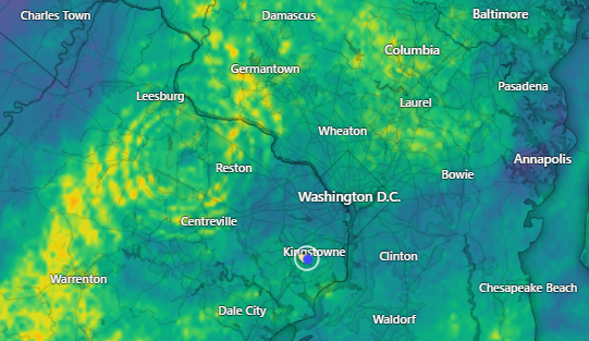
Interesting radar screencap snapped from Windy a few moments ago...can't remember seeing that "radiating wave" pattern emanating from LWX radar site before.
-
1
-
-
3 hours ago, snownut said:
What time are the storms rolling through IAD? Probably a bumpy flight.. I am scheduled to land at 5:45

-
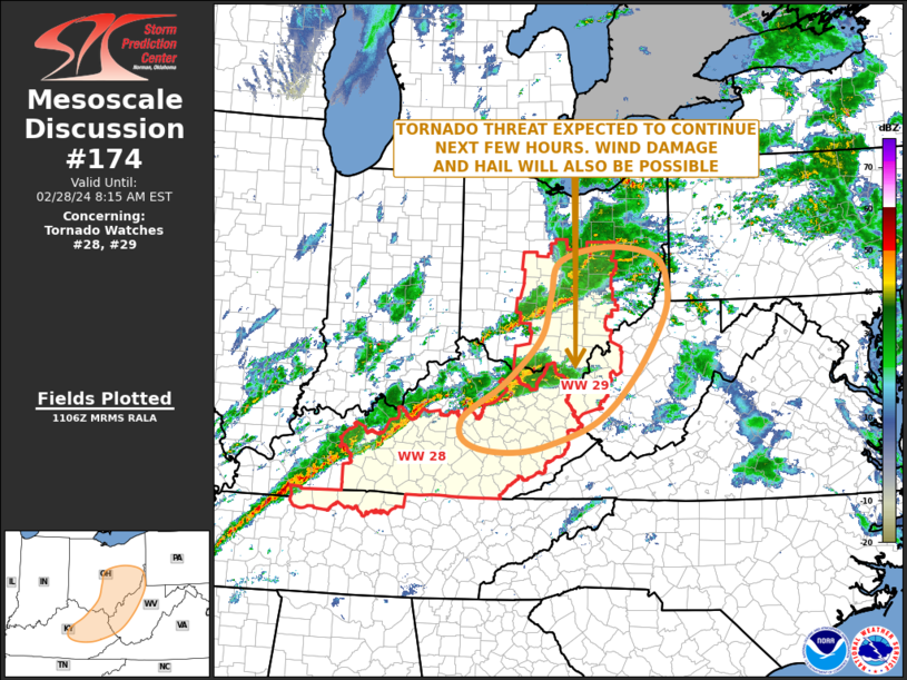
Excerpt from this morning's LWX disco and SPC's Day 1 outlook...incoming radar is pretty lit.
The heaviest precipitation looks arrive later this afternoon and
into this evening (3-8pm) before things quickly ending from west to
east before midnight. Thunderstorm probabilities are low, but are
not zero, for this front, given the increasing dewpoints and strong
forcing. A marginal risk for severe weather has been issued from
north-central MD and northern VA west into the MD/WV mountains.
Forecast instability values are generally less than 500 J/kg with 0-
6 km shear values over 50-60 kts. With that said, a narrow line of
shallow convection may develop along and ahead of the front later
this afternoon and evening. Lightning will be limited with wind as
the main concern as this linear convective line pushes through.
Gusts of 45-55 mph can be expected with this convective line of
showers as it pushes from west to east across the region.
Rainfall amounts 0.5 to 1 inch can be expected areawide outside
of the Alleghenies where 1 to 2 inches of rain is expected.
Flood Watches remain in effect for western Grant, western
Mineral, and Garrett counties to encompass this heavier rain
threat combined with already saturated soils and elevated from
melted snowpack in this area.
-
2
-
-
Currently 61/44 here, vigorous radar to our west approaching the Apps.
-
11 hours ago, Ji said:
Are we still panicking?
More like sullen resignation...punctuated with monologues, accusations, tantrums and catfights.
#JustAnotherWinterOnTheMASub
-
1
-
-
21 hours ago, Rhino16 said:
Got 2 lightning flashes yesterday while taking weather class tests… let’s see if we get anymore today or tomorrow. Maple trees have red nibs on the end, and flowers are coming up. It’s spring.
Trees and daffodils/crocuses have been hammer-down around here for the past two weeks, but the biggest tell was the huge chorus of peepers singing last evening in the wetlands surrounding our neighborhood.
-
3
-
-
7 hours ago, nj2va said:
Great weekend weather coming up to tend to yard work outside the 30-50% rain chances. I’ll be doing some leaf cleanup for whatever stragglers got blown into our yard, cleaning up the herb garden, and putting in the mulch delivery order.
Need to try my hand at an herb garden, always wanted to...have an awkward, corner-ish alcove in the backyard that would be a perfect spot.
-
2
-


Late Feb/March Medium/Long Range Discussion
in Mid Atlantic
Posted
I'm thinking that @CAPE would agree with you, based on what he's facing on his "back 40" in the coming weeks...")