

MD Snow
-
Posts
1,875 -
Joined
-
Last visited
Content Type
Profiles
Blogs
Forums
American Weather
Media Demo
Store
Gallery
Posts posted by MD Snow
-
-
This. I wouldn’t be talking about THIS depressing BS if we had anything optimistic at all to discuss.
March 9-12 might end up being interesting for someone along the east coast…
.-
 1
1
-
-

This makes we want to punch furry woodland creatures.
-AO/NAO, PNA ridge. And…TORCH
I get it. But it’s on march 10 after the Conus has been flooded with pac puke for weeks. I agree things are getting worse for snow but not sure if this example is the best.
I don’t know. I get your frustration. I sometimes wonder if your frustration would be tempered if you lived and experienced what we in the lowlands experience regularly…I know you lived here at one point…If my mean snowfall was almost 40” I’d be pissed to. But we’re like 12-16” down here. We don’t get as much but it doesn’t take near as much to meet expectations. We also have a higher fail rate than you do. Winter of 20/21…I got dustings to an inch here and there to ice over and over again while you racked it up.
. -
Still some potential on the ops for a sneaky event in the next ten days. Active northern stream with “cold enough” not that far away.
. -
36/24
Bummer this may end up being drier. Temps have cooled nicely.
.-
1
-
-
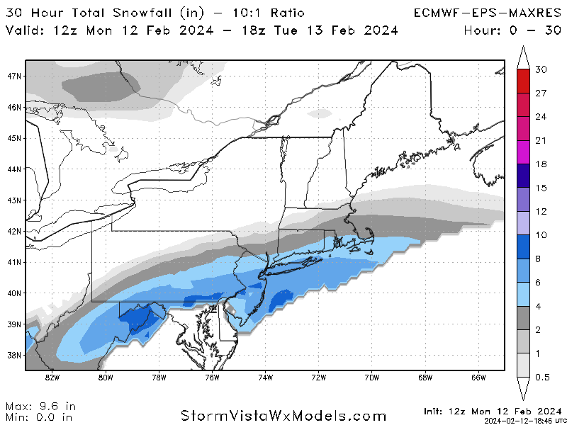
HRRR has areas east of 95 raining for 1-2 hrs before the change over. It really only actually snows for 2 hrs east of 95 between dc/Balt. Will be interesting to see if this verifies.
.-
 1
1
-
-
Yeah but the RAP/HRRR and RGEM are also on the lower end as well.
The rap and hrrr were giving me 2-8” on Tuesday morning. Got nothing.
.-
 1
1
-
-
Except it falls overnight and never gets above 35 on Saturday
40+ for us in the coastal plain…
. -
GFS has a lot going on with the H5 look around 141 hours and after
Cmc also.
.-
1
-
-
Weird times. Last week was the best pattern in the last ten years on our doorstep. 3 discreet threats. Today, 19-20 and 23-25. Then the pattern got canceled. But there’s still a pretty decent chance some in the forum will end up going 3/3 with accumulating snow with all three threats. You’d think this board would be hopping with the potential. However, it’s about as as dead as it gets with most looking to the spring.
.-
2
-
-
I don’t think this is right, but…
The accumulation map makes sense if the storm evolution plays out like the op euro is depicting. If you have rates, it will accumulate into the metro’s. If it’s drier and precip is
Lighter like the op euro shows, it will only accumulate in favored areas.
.-
1
-
-
You know what? They're like 300 miles away from us and they get far more snow than we do year after year. Not sure I can feel for them after what we've been going through these past many years and the epic long-range fail period we're heading into.
They’ve had a pretty rough go of it over the last few years as well.
. -
Ignore Ji. But given such an extreme -epo, -nao, -AO pattern the temperatures being shown on guidance are pretty underwhelming. I didn’t expect it to be arctic cold. But even with a good flow we would need a damn perfect no wiggle room wave pass with some of the thermals.
Did you see the cmc? Is snowing in Mexico “Deep South” enough? You’ve been harping on how terrible the gfs is doing with the the long range pattern progression yet using it to make a point about no cold air in the long range. All the while other guidance is a good bit colder. Let it play.
.-
1
-
 1
1
-
-
Hmm. This was a pretty big shift. We'll probably get a compromise, which isn't gonna do it for us.
Or you could say, one more shift similar to this and we’re all in the game. It’s already happened this year…atmospheric memory for the win baby!
. -
Euro has some flakes nearby on the 16th as cold air pushes in
This disturbance has been showing on guidance on and off for a while now. Might be a way to luck into something, especially if it falls at night.
. -
Unless I’m delirious. GFS??
Yup.. a terrible model.
. -
Well…let’s all hope the gfs isn’t on to something.
. -
PSU fringed…short pump crushed!
.-
3
-
-
Where is Ji??? Digital blue alert!
. -
Is it just me or is the biggest issue with the first part of the incoming pattern through pday or further going to potentially be a lack of cold air? Can anyone with knowledge speak to this. 500 charts at the end of both gfs and cmc ens seem to be kind of a pac puke look for our latitude with cold air stuck to the north. Trying to learn here.
-
Pretty crazy H5 evolution next week for the fish storm. Just out of curiosity, what would it take to tug it a little closer to the coast?
. -
Differences between the GEM and GFS are crazy at 168.
. -
I know this is in jest, but the period jan 28-31 is one to watch even in a lousy pattern. Going to be a needle threader or late miller B or may just be a perfect track rainstorm, but we’re still in the game. Wouldn’t count us out yet all the way to 2nd week Feb
Yup. Most likely a hit for the northeast but it is a threat worth tracking. That’s all I ask for in winter. Threats to track…
. -
Why is everyone being so negative!?!
.-
2
-
1
-
-
You’re right. It’s over. Move on
I’m not writing it off. It just seems like the Nam’s were a bit north from 6z. Rgem hardly gets any precip to Baltimore south. Still a good chance we get 1-3” but Baltimore south has very little margin for error.
.

Late Feb/March Medium/Long Range Discussion
in Mid Atlantic
Posted
And I’m sure, reminding us of our perfect track rain storm!
.