

kvskelton
-
Posts
285 -
Joined
-
Last visited
Content Type
Profiles
Blogs
Forums
American Weather
Media Demo
Store
Gallery
Posts posted by kvskelton
-
-
MRX has issued a WWA for part of the forum area in regards to this system.
---------------------
URGENT - WINTER WEATHER MESSAGE
National Weather Service Morristown TN
318 PM EST Wed Jan 17 2024

TNZ012>017-035>040-042-044-046-067-069-070-073-181000-
/O.NEW.KMRX.WW.Y.0003.240119T0000Z-240120T0000Z/
Scott TN-Campbell-Claiborne-Hancock-Hawkins-Sullivan-Morgan-
Anderson-Union-Grainger-Hamblen-Northwest Cocke-Northwest Greene-
Washington TN-Northwest Carter-Roane-Knox-Jefferson-North Sevier-
Including the cities of Big South Fork National, Oneida,
Smokey Junction, Elgin, Huntsville, Norma, Slick Rock, Fincastle,
La Follette, Elk Valley, Jellico, White Oak, Caryville,
Royal Blue, Lone Mountain, Sandlick, Springdale, Arthur,
Harrogate-Shawanee, Clairfield, Howard Quarter, Evanston,
Sneedville, Treadway, Kyles Ford, Mooresburg, Kingsport,
Bristol TN, South Holston Dam, Pine Orchard, High Point, Petros,
Oak Ridge, Clinton, Maynardville, Norris Lake, Paulette,
Rose Hill, Sharps Chapel, Luttrell, Bean Station, Alpha,
Morristown, Russellville, Bybee, Newport, Greeneville,
Johnson City, Elizabethton, Harriman, Eagle Furnace, Rockwood,
Bradbury, Fairview, Kingston, Oliver Springs, Bearden, Knoxville,
Lake Forest, Jefferson City, Strawberry Plains, Chestnut Hill,
Dandridge, White Pine, Harrisburg, Kodak, McMahan, Sevierville,
Seymour, and Pigeon Forge
318 PM EST Wed Jan 17 2024

...WINTER WEATHER ADVISORY IN EFFECT FROM 7 PM THURSDAY TO 7 PM
EST FRIDAY...

* WHAT...Mixed precipitation expected. Total snow accumulations of
  up to one inch and ice accumulations up to one tenth of an
  inch. Winds gusting as high as 35 mph.

* WHERE...Northern and central portions of East Tennessee.

* WHEN...From 7 PM Thursday to 7 PM EST Friday.

* IMPACTS...Plan on slippery road conditions. The hazardous
  conditions could impact the morning or evening commute.

PRECAUTIONARY/PREPAREDNESS ACTIONS...

Slow down and use caution while traveling.

The latest road conditions for the state you are calling from can
be obtained by calling 5 1 1.

&&

$$
-
 3
3
-
-
3 minutes ago, PowellVolz said:
Radar last night showed a couple of intense long gated bands track in that area. Seen a couple of tweets of almost whiteout conditions.
.Thanks PV. That makes perfect sense. I allowed myself to get distracted last night with holiday preparations and wasn't paying attention to RadarScope.
")
-
Was surprised to find a solid dusting at my place in the Colonial Heights area of Kingsport this morning. Nothing on the roads but more white than grass in the area yards. That changed quickly as I drove into Kingsport for work, as most other areas had little or no accumulation on my way into downtown. We must have just caught a good squall at my location. Still, a nice beginning to Christmas week!
-
4
-
-
Thunder overhead in downtown Kingsport. I'm sure there's an old Wive's Tale about "Thunder in December" but I'm unsure what that would entail. With my luck maybe "unexpected appearances by an ex-wife" or "leaky head gaskets by Christmas" or some such. Shame my old Mamaw isn't here to enlighten me to the portent of this storm!
-
3
-
-
44 minutes ago, Carvers Gap said:I am just north of it. I can hear the thunder with it though.
Seemed to weaken a touch just prior to getting to my location. Still a strong storm but it seems the tornadic activity was no longer being seen on radar by the time it reached here.
Have to admit, seeing that tornado symbol heading toward me on Radarscope was a bit unsettling!
Sent from my SM-G781V using Tapatalk
-
1
-
 1
1
-
-
Just now, 1234snow said:
WJHL was showing a CC drop but very hard to tell if I was an accurate reading. Please be safe in the Kingsport area especially on south side of town.
We're hunkering down in Colonial Heights. Looks to be headed this way according to Radarscope. Y'all be safe!
-
3
-
-
Currently in Halls. Barely got the front yard mowed before the pop up storm hit. It had been thundering for about 20 minutes beforehand. (And I hate working outside when it's thundering) Had a few hits of pea sized hail with the initial storm.
Unnervingly quiet now as we wait on the main line to move in.
Sent from my SM-G781V using Tapatalk-
2
-
-
2 minutes ago, TellicoWx said:
Big concern for the Valley on the low level moisture is the DGZ speed lowering and how dry it is. The residual could be squeezed out in the form of light drizzle/fog creating a nightmare glaze on everything. Won't take very much drizzle to instantly freeze on contact for things to go down hill quickly.
This is my second biggest concern for our area, just behind downed trees causing power outages. Crashing temps causing a "flash freeze" would spell disaster in general but especially on the roads. I have a friend coming from Atlanta today and my brother is driving back from Indiana as I type. I've told them both to be in place before midnight if possible. Hopefully traffic will have decreased somewhat by the time it arrives in our part of the Valley. I hope everyone (i.e., the general public) is up to date on things and are planning accordingly but honestly how many folks are keeping up with the storm the way we are?
Speaking of which, thanks to y'all for the great coverage...as always!
-
3
-
-
10 minutes ago, BlunderStorm said:
A moment of silence for @BuCoVaWxfrom that SWVA GFS screwjob.
lol. I'd say the same to kv and carver joking too... but the kingsport snowhole is a genuine phenomenon.
Hoping the rapidly intensifying cold can overcome the Eastman Dome.
-
4
-
-
1 hour ago, Hurricaneguy said:
I know a lot can change by Saturday evening but does anyone have an explanation for why East TN looks to strike out again on a good snow for their third time in a row?? Bad luck every time? I can’t help but think climate change is impacting this region in the last several years. It’s been so long since most of our region has a good widespread 8 inch + snow.
Unfortunately it's not really that surprising, nor has it been for quite a while. When you figure in warm nose, dry slotting and the dreaded "cold chasing rain" that always seems to plague parts of the valley (not to mention the various micro climates and the dreaded "Eastman Dome"), big hitters are usually a gamble in our area. And each part of the valley has its own set of unique circumstances that factor into the results of each system. Basically, a lot of things have to go right for us to get a wide spread "big dog."
I'm an old guy (well, 57) and remember when 6" snows were the norm, not the exception. And while yes, wide spread 8" snows are rare these days, Kingsport had over 9" on 9 DEC 2018. My advice is hang on, don't live and die by the next model run (not saying you are, just saying to folks in general) and enjoy whatever comes. Yes, we may miss out but someone in our forum area will probably jackpot with this one. I'm happy for them and know that eventually we'll get our turn. Of course I was 29 when the Blizzard of 93 hit, so I've got no right to hope for snow the rest of my life!
-
5
-
-
14 minutes ago, bearman said:
My Radar scope is having problems but it looks like mosture is about to get into west knox at least from looking at the radar out of Nashville MRX is an hour and 45 min old. That is moving fast.
Having the same problems with Radarscope in regards to the Morristown MRX radar. Latest reading is over 2 hours old, while Nashville MRX reading is current. Poor time for this to happen.
-
On 11/14/2021 at 3:29 PM, nrgjeff said:
If you can only remember one bear rule, just don't F* with mamabear or her cubs!
What a perfect segue into another episode of Story Time with the Old Surveyor.
About a dozen years ago I was behind a surveying instrument as we did a topographical survey in the Bays Mountain area of Kingsport. It was late spring and the weather had turned nice, though the leaves were barely budding out. I was on a slope of about 30 degrees or so. Focused on the rodmen, I had this strange sensation that I was being watched. After a moment I looked to my right (down slope). About 75 yards away, with her back up against an old hickory stump was a goodly sized black bear. She was sitting on her haunches and her eyes were locked on me. That was pretty unnerving...but what really got my heart racing were the two cubs playing at her feet! Needless to say, the surveying instrument was left behind as everyone made a quick exit until she and her youngin's made a leisurely departure.
I've had encounters with lots of wildlife during 30 years of surveying, but that one really got my attention.
-
3
-
-
SPC AC 250559

   Day 1 Convective Outlook
   NWS Storm Prediction Center Norman OK
   1259 AM CDT Thu Mar 25 2021

   Valid 251200Z - 261200Z

   ...THERE IS A HIGH RISK OF SEVERE THUNDERSTORMS ACROSS PARTS OF
   CENTRAL...EASTERN AND NORTHERN MISSISSIPPI INTO NORTHWESTERN ALABAMA
   AND SOUTHERN TENNESSEE...

   ...SUMMARY...
   A tornado outbreak is expected today into early this evening across
   parts of the Southeast northward into the Tennessee Valley. Several
   long-track strong tornadoes, destructive winds and very large hail
   are forecast from the Lower Mississippi Valley, eastward across
   parts of the Southeast and northward into the Tennessee and Ohio
   Valleys.

   ...Tornado Outbreak Expected Across Parts of the Southeast and
   Tennessee Valley Today into Early This Evening...

   ...Southeast/Tennessee and Ohio Valleys...
   A potent shortwave trough and an associated 75 to 90 kt mid-level
   jet will eject quickly northeastward across the southern Plains
   today. At the surface, a low will move northeastward and deepen
   across the Arklatex and mid Mississippi Valley today. Strong
   moisture advection will take place in the lower Mississippi Valley
   as a 50 to 65 kt low-level jet strengthens. Surface dewpoints will
   increase into the 65 to 70 F degree range by late morning throughout
   much of eastern Louisiana, Mississippi and western Alabama. The
   low-level moisture combined with surface heating will result in a
   moderately unstable and volatile airmass by late morning. A band of
   strong large-scale ascent, in advance of the shortwave trough, will
   move quickly northeastward across the Arklatex this morning.
   Convection appears likely to initiate around midday ahead of this
   band of ascent from southeast Arkansas southward into northeast
   Louisiana and eastward into southwest Mississippi. This cluster of
   thunderstorms is expected to organize and rapidly intensify, moving
   northeastward across central and northern Mississippi into
   northwestern Alabama during the afternoon. Moderate instability,
   strong deep-layer shear and impressive amount of lift on a large
   scale will be favorable for widespread severe thunderstorm
   development, and a tornado outbreak is expected.

   RAP and NAM Forecast soundings this afternoon across the warm sector
   from central Mississippi northeastward into northwest Alabama show
   an impressive environment for severe storms. MLCAPE is forecast to
   increase into the 2000 to 3000 J/kg range across much of central and
   northern Mississippi by midday. Surface winds are forecast to become
   backed to the south-southeast across the eastern half of
   Mississippi. This combined with 60 kt of flow near 850 mb will
   result in 0-3 km storm relative helicities in the 400 to 500 m2/s2
   range. In addition, the progressive nature of the mid-level jet will
   be optimal for the development of tornadic storms. Supercells are
   forecast to develop rapidly after initiation across central
   Mississippi early this afternoon and move quickly
   north-northeastward into northeast Mississippi. Significant tornado
   parameter is forecast to increase to near ten across northeast
   Mississippi and northwest Alabama by 21Z, making conditions very
   favorable for long-track strong tornadoes. As the low-level jet
   consolidates and couples with the progressive mid-level jet, a
   violent long-track tornado will be possible.

   The cluster of severe thunderstorms is expected to move from parts
   of northern Mississippi and northern Alabama into the Tennessee
   Valley late this afternoon and early this evening. Supercells and
   bowing line segments will likely be severe, producing wind damage,
   tornadoes and large hail. Hailstones greater than 2 inches in
   diameter may occur with the stronger updraft cores. The wind damage
   threat is forecast to become more widespread as a squall line
   organizes along a cold front in the Mississippi Valley. This line of
   severe storms is forecast to move quickly eastward across the Ohio
   and Tennessee Valleys this evening, producing widespread wind
   damage. Wind gusts of greater than 65 knots will be possible.

   Further north in areas near the Ohio River, instability is forecast
   to be considerably weaker than in areas to the south. In spite of
   the weaker instability, enhanced lift and strong deep-layer shear
   will make severe storms possible. As storms move north-northeastward
   across the Ohio Valley this evening, isolated large hail and wind
   damage will accompany supercells and bow echoes. An isolated tornado
   threat will also exist.

   ..Broyles/Cook.. 03/25/2021

   CLICK TO GET WUUS01 PTSDY1 PRODUCT

   NOTE: THE NEXT DAY 1 OUTLOOK IS SCHEDULED BY 1300Z
   CURRENT UTC TIME: 1157Z (7:57AM), RELOAD THIS PAGE TO UPDATE THE TIME
-
12 minutes ago, Carvers Gap said:
That is crazy, man. I am just looking at who doesn't have ice so I can show up unannounced like Cousin Eddie.
I don't know, Carver's; looking at that map we may be in he best spot possible!
Is that area of less zr from Johnson City to near Wytheville caused by the warm air taking longer to be scoured out after being trapped by the front or are the Apps wringing out moisture? Or the TEC dome? Oh and be sure to get yourself something REAL nice!
3 minutes ago, Holston_River_Rambler said:People better stock up on beer and cigs, cause the police ain’t bringing em.
Holston, in case you didn't hear that full story, that was an actual announcement made on the radio (WQUT) several times during the Blizzard of 93! I'm honored that Stovepipe keeps it alive in his signature!

-
1
-
2
-
-
1 hour ago, Holston_River_Rambler said:
@Greyhound some hopeful person went in to his Wikipedia page and edited it, lol (not me). I was just reading some of the more excitable twutters on VOL twitter claim that there was a plane from State College meeting one from UT and decided to see if someone had edited it. Yup. It's back to normal now though.
A friend of mine sent me a link this afternoon and evidently someone had also edited the wiki page of Tony Elliot saying he was the new coach at UT! Someone's having fun with the UT fans, I do believe...
-
1
-
-
Thunder rumbling in Kingsport at the moment...
-
4
-
-
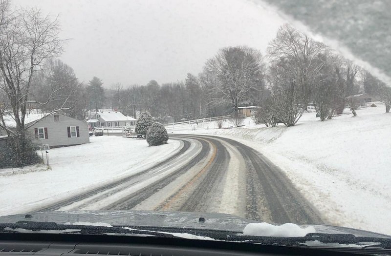
Pictures from my daughter in Bristol, VA. She said the trip in to work was dicey. Thankfully her boyfriend has a 4wd.
-
13
-
-
2 minutes ago, Dsty2001 said:
This just popped on my phone
Beat me to it, Dsty2001!
-
Just now, Dsty2001 said:
MRX does their typical play it conservative thing. Not sure that is a good idea in this situation
Not for TRI!
Winter Storm Warning
URGENT - WINTER WEATHER MESSAGE
National Weather Service Morristown TN
351 PM EST Thu Jan 7 2021

TNZ016-017-039-040-042-044-046-070-071-073-VAZ008-080500-
/O.EXB.KMRX.WS.W.0001.210108T0600Z-210109T0000Z/
Hawkins-Sullivan-Hamblen-Northwest Cocke-Northwest Greene-
Washington-Northwest Carter-Jefferson-Northwest Blount-
North Sevier-
Including the cities of Mooresburg, Kingsport, Bristol TN,
South Holston Dam, Alpha, Morristown, Russellville, Bybee,
Newport, Greeneville, Johnson City, Elizabethton, Jefferson City,
Strawberry Plains, Chestnut Hill, Dandridge, White Pine,
Happy Valley, Maryville, Alcoa, Harrisburg, Kodak, McMahan,
Sevierville, Seymour, Pigeon Forge, Benhams, Bristol VA,
and Abingdon
351 PM EST Thu Jan 7 2021

...WINTER STORM WARNING IN EFFECT FROM 1 AM TO 7 PM EST FRIDAY...

* WHAT...Heavy snow expected. Total snow accumulations of 2 to 5
  inches, with increased amounts possible in the higher
  elevations.

* WHERE...Portions of east Tennessee and southwest Virginia.

* WHEN...From 1 AM to 7 PM EST Friday.

* IMPACTS...Plan on slippery road conditions. The hazardous
  conditions could impact the morning or evening commute.

PRECAUTIONARY/PREPAREDNESS ACTIONS...

The latest road conditions for the state you are calling from can
be obtained by calling 5 1 1.

Stay tuned to NOAA Weather Radio or your favorite source of
weather information for the latest updates. Additional details
can be found at www.weather.gov/mrx.
-
1
-
-
1 hour ago, Holston_River_Rambler said:
O Fortuna,
velut Luna
statu variablilis
semper crescis
aut decrescis
nive detestabilis
SREF nunc obdurat
et tunc curat
ludet mentis aciem
Good one Holston! I knew that class in Latin would come in handy one day!

-
 2
2
-
-
10 minutes ago, BuCoVaWx said:
Hey guys. Another long time lurker here. I live in SW VA, Buchanan County to be exact, on the KY state line. Maybe you can help with a couple of questions. First, am I in the right forums lol. Seems this one is closer to me. Second, will Grundy, VA have any luck with this coming system. By luck I mean snow accumulation lol. Thanks in advance!!
@BuCoVaWx Welcome! You're definitely in the right forum!
I think like most of us in the NETN/SWVA area, the model trend of the storm backing to the NW is concerning. That said I think we're still in the game for accumulation. The next few model runs will be very telling. If the NW trend continues, then I'll be concerned for my back yard for sure.
-
1
-
-
4 minutes ago, Kentucky said:
always on the edge here, it usually doesn't work out more than it does.
@Kentucky I believe that can be said by most of us in this forum!
@bluegrassweather71 Welcome to the forum! I'm a longtime member with a terminal case of lurkeritis myself. Great to have you join us!
-
1
-
-
16 hours ago, John1122 said:
Apparently Pruitt was maybe paying players and recruits. I have no idea how he could be cheating like Alabama but producing that result on the field.
My main hope is that it allows him to be fired with cause and saves UT 12 million in buyout money.
We aren't going to be any worse on the field regardless of the outcome.
I think the timing of this investigation could be very telling. I have heard that a level 1 or 2 violation could result in Pruitt being fired with cause and without a buyout, where a lower violation could give UT the leverage to negotiate a lower buyout. If UT could negotiate a lower buyout, while giving up a bowl game this year (much like LSU has done) and maybe lose a scholarship or two for a brief period, I think the University comes out way ahead. Especially factoring in that payments to Butch Jones for his buyout are over in February, I believe (Though the last 1 or 2 may be eliminated by his taking the HC job at Arkansas State).
I think Pruitt is a very good DC and may make a decent HC one day. But the lack of development of the Vols after his 3 years of being head coach is telling as to his ability to lead a P5 program at this time. Then again it's 2020, so heck, he may end up with another extension and raise for all I know!
-
3
-
-
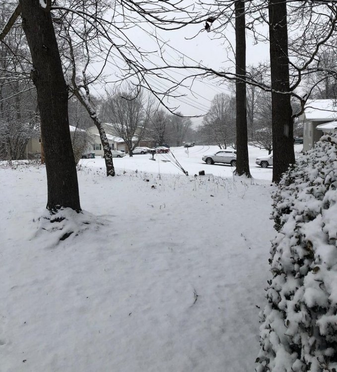
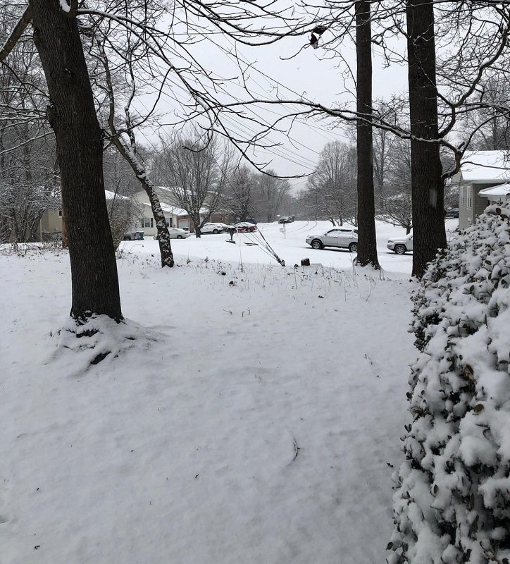
Had a light dusting in the Colonial Heights area of Kingsport this morning. It was a nice surprise!
Got this photo from my daughter from her place in Bristol, VA this morning as well. Looks like they did well!
-
9
-

Winter 23-24' Wx Observations Thread
in Tennessee Valley
Posted
Looking at the origin point of that return I immediately thought of the Bays Mt Reservoir that sits on top of the mountain. Lake effect virga? I, too, thought it was strange occurring on that side of the mountain.
@Carvers Gap I knew that would be in your neighborhood! If the black SUVs show up, get downtown and I'll hide you at my office! It was nice to meet you face to face a couple years ago. It is indeed a small world!