

katabatic
-
Posts
276 -
Joined
-
Last visited
Content Type
Profiles
Blogs
Forums
American Weather
Media Demo
Store
Gallery
Posts posted by katabatic
-
-
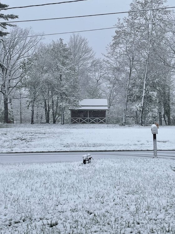
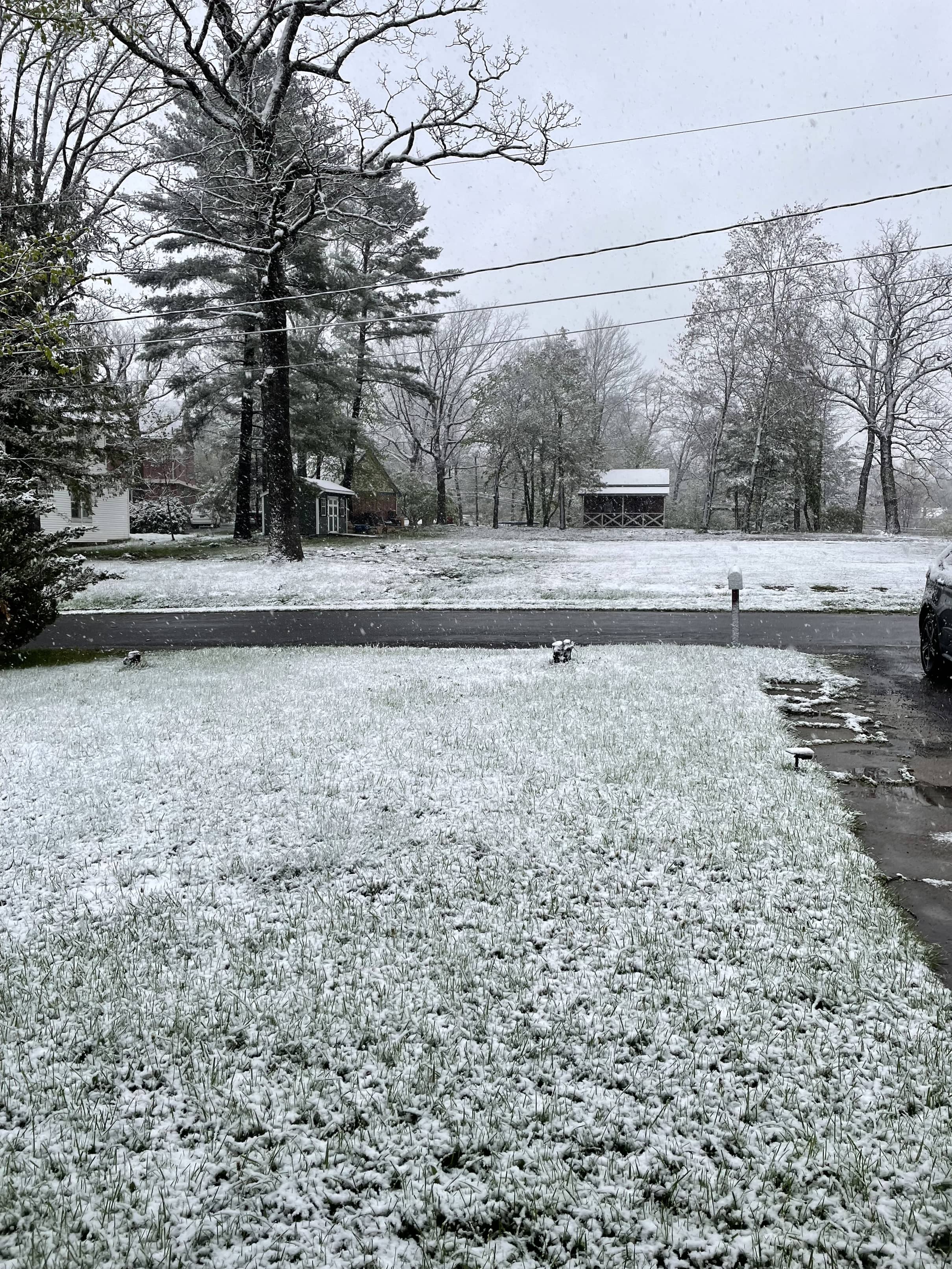
Pretty good soaking this morning - 0.92" so far. When the sun and warmth come back tomorrow, the final burst of greenup will commence.
-
Final pic after an impressive snow shower came through. The roads (briefly) caved. Ended up with 3.5” on the car…less elsewhere. Neat event. Damn near the “biggest” all season.
-
 12
12
-
-
While this doesn’t compare to Davis/Snowshoe, nevertheless a beautiful scene in Mountain Lake Park this morning.

-
12
-
-
We have had snow flurries off and on all morning (no accumulation) with up to 3 inches in GC tonight (WWA hoisted about an hour ago). Pretty neat honestly.
-
1
-
-
Front has passed through SW Garrett County. Will be interesting to see if a fraction of those (seemingly outlandish) modeled upslope snow totals come close to verifying outside of Snowshoe/Canaan.
-
19 minutes ago, nj2va said:
#deckpic

What a difference a few miles makes. Had some flakes earlier but absolutely zero on the ground and 34.
-
54 mph gust and 0.26” rain in ~8 minutes with small hail and a single rumble of thunder just now. You know, typical Garrett County February weather.
-
6
-
-
1 minute ago, Terpeast said:
Solid disco in LWX AFD:
Thereafter, forecast uncertainty begins to increase as we move into
Thursday and Friday. On Wednesday, a strong cyclone in the Gulf of
Alaska will build a downstream ridge, which is modeled to progress
eastward into the CONUS with an appreciable forward speed. As this
ridge builds downstream, it will perturb the downstream waveguide,
which has been relatively stagnant over the past week. In response to
the ridgebuilding, troughing will dig into the Desert Southwest/Four
Corners region Wednesday night, and then progress eastward onto the
Southern Plains Thursday into Thursday night. Meanwhile, the upper
ridge will progress eastward and interact with a downstream upper
low over Hudson Bay. Exactly how this complex process plays out will
have a major impact on our forecast. The 00z Euro and 00z Canadian
have the ridge progress eastward at a higher forward speed than the
trough within the southern stream. As a result, the ridge cuts
overtop of the shortwave trough as it closes off, effectively
keeping it suppressed to the south as it progresses eastward. In
these scenarios, the potent upper level shortwave progresses
directly overhead, with an intense area of low pressure at the
surface progressing to our south. The 00z GFS on the other hand,
doesn`t have the upper ridge build overtop the southern end of the
trough, and maintains one coherent north-south oriented wave from
Canada down into the Southern Plains. This scenario allows the
southern stream shortwave to amplify further and gain more latitude
as it progresses toward the east. This scenario results in a very
intense area of low pressure tracking off to our north and west.
Such a scenario would place us on the warm side of the system, and
would result in temperatures climbing into the 60s or 70s, along
with heavy rainfall, and potentially even severe thunderstorms. The
scenario depicted by the Euro and Canadian on the other hand would
produce a significant amount of snowfall across the area, with
temperatures holding in the 30s.

In both of these scenarios, Thursday would have relatively quiet
weather, with northwest winds, and potentially a few showers. The
main forecast uncertainty on Thursday would lie in the high
temperatures forecast. Ensemble guidance has highs on Thursday
ranging from the 40s to the 70s.  The higher impact weather, whether
it be in the form of heavy rain and thunderstorms, or snow, would
move in on Friday and last into Friday night.

With such a highly uncertain and complex forecast, it`s important to
think probabilistically. The deterministic models described above
span the phase space of potential outcomes outlined in the ensemble
guidance. The system being suppressed far to our south and
completely missing us (as some ensemble members showed yesterday)
appears to be off the table. The two main scenarios now entail the
low passing to our north and west, and us ending up on the warm
side of the system, and then the low passing to our south, and us
ending up with wintry precipitation on the cool side of the system.
In terms of temperatures, these solutions range from highs in the
70s, to highs in the 30s. As a result, our deterministic forecast
(that you see in the point and click forecast on our website) is a
middle of the road solution and calls for highs in the 40s/50s, and
rain across much of the area (since you can`t have snow with
temperatures in the 50s). Nonetheless, the chance for snow is a very
real one.

Digging a bit into the probabilistic phase space, and individual
ensembles, both the EPS and GEPS trended colder and snowier with
the 00z model cycle, especially across the northern half of the
forecast area. The EPS and GEPS now shows a greater than 50 percent
chance for accumulating snow across nearly all of the forecast area,
as well as a greater than 50 percent chance for more than a half
foot of snow across far northwestern portions of the forecast area
(Potomac Highlands and western Maryland). The GEFS on the other hand
stand in stark contrast to the EPS and GEFS. The GEFS actually
trended warmer, and less snowy, with very low probabilities for any
snow, let alone significant snow. Oftentimes, the GEFS tends to
follow trends in the GFS very closely, so this trend is somewhat
unsurprising. In all of the respective ensembles, probabilities for
snow are greater further off toward the north and west, and lesser
as you progress further off toward the south and east. At the
moment, this is a very challenging and highly uncertain forecast for
Friday. We`ll continue to monitor trends and adjust our forecast
accordingly as we progress through the week.

All solutions show us drying out on Saturday as winds turn
northwesterly behind the departing low.
They’re just as excited to finally have something to write about as we are to track.
-
1 hour ago, Stormchaserchuck1 said:
I like it. We're sticking to a wetter STJ as the pattern probably changes. Like the March 9-19 window.

A very hopeful 3-4 week disco from CPC along with their revised maps showing well BN temps throughout most of the country supports this.
-
Almost made it. 1.9.
-
For those coming to Garrett County, best winter day thus far. Intermittent snow falling now with winds IMBY gusting to 43 mph. Temp is 29.4 and has been slowly falling all night. Impossible to measure but eyeballing between 1/2 to 1 inch thus far. Rates look to pick up through the day with NWS forecasting 7” in Oakland. @Terpeastyou picked a good weekend!
-
1
-
 1
1
-
-
2 minutes ago, nj2va said:
I’m home in Alexandria but weather station says 31 with freezing rain at the house. What a terrible winter even in the mountains.
Your bit of elevation helps. It’s 33.6 in MLP although we got 2.2 inches over the course of Friday thru early Saturday AM but a disgusting light rain and 33-34 all afternoon today. LWX is calling for 4” beginning with tonight’s passage and interested to see what the end of the week brings. “Prolonged” doesn’t mean significant.
-
After a week of spring, hoping that’s the end of it for a while. May get some flakes here tonight. Down to 31.4.
-
2 hours ago, Terpeast said:
Nice! Definitely can swing that. I think psu mentioned this recently, too but I forgot the name.
How far ahead of time? A couple days? Weeks?
Another option is Wisp. Quick glance shows availability on the 14h of January. My husband is a lift operator there and even today the area was manageable. By the 14th we will have had some colder weather and while Mother Nature looks stingy AF re: natural snow, it’ll be cold enough to make it.
-
1
-
-
1 minute ago, Rhino16 said:
6.8° now. Still falling fast! I don’t think it’s snowing anymore, but I don’t get radar here so I can’t tell. Very windy.
Where are you?
-
Temp at 5:38 was 35.4
Temp at 6:42 was 21.9
Heavy snow currently (I’m at 2,438’)
-
4
-
-
Front has passed, as expected an abrupt wind shift. Switched to snow immediately. Temps quickly rose from 29.3 to 35.4 immediately before fropa and are now 30.5 (dropping 0.2 degrees every 30 seconds or so).
-
4
-
-
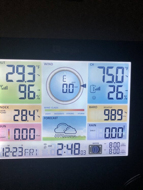
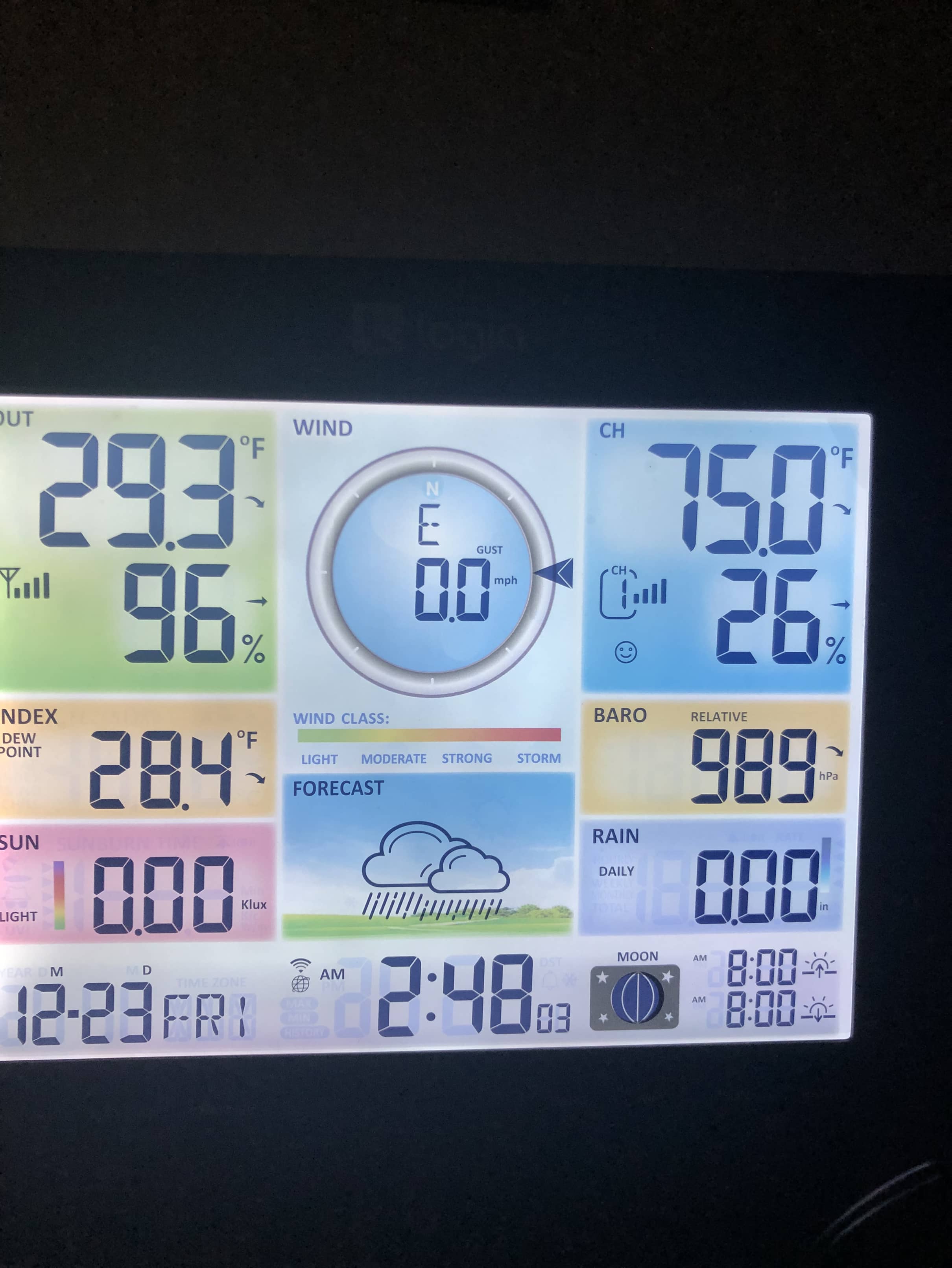
Baro down to 989 in southwest Garrett County. Never got above freezing with a ton of ice still on the trees.
-
1
-
-
18 minutes ago, ravensrule said:
You live a few miles from the PA border and about 9,000 miles from Trixie. I don't understand the hate here. As long as the person is a good poster, who cares if they live .0000001 miles outside of our "official" sub forum.
THIS TIMES A MILLION.
-
7
-
-
Now ZR in MLP. I hope we rise above freezing long enough this evening to melt what accretes with the wind coming. Fairly light returns downwind (good accretion) and already small icicles on the trees.
-
28.5/26.4 in Mountain Lake Park. Had some decent snow (after starting out as ZR and temps right at 32) but is now almost all sleet. About an inch of slop, maybe a tad more.
-
1
-
-
Interesting inversion last night. 7.3 for a low here and in McHenry (about 350’ higher and ~12 miles north), 14.6.
-
4 minutes ago, RIC_WX said:
Feels like deep winter this morning
It really is. Steady snow, gusts to around 20 mph and temps in the low 20s. Spectacular morning.
-
3
-
-
22.1 and steady snow this morning. Beautiful, light upslope event. 1.9” since last night on top of last weeks glacier.
-
8
-


May Discobs 2023
in Mid Atlantic
Posted
Spectacular (albeit cool) spring day. Morning low of 37.1, currently 63.8. Looking forward to tomorrow's mid 70s. Bring it!