

BlizzardNole
-
Posts
2,289 -
Joined
-
Last visited
Content Type
Profiles
Blogs
Forums
American Weather
Media Demo
Store
Gallery
Posts posted by BlizzardNole
-
-
We got a pop-up shower a while ago that must've dropped more rain in 5 minutes than we got all weekend. It went from zero to POURING in seconds. Now the sun's back out. I need to get my darn gauge up
-
 1
1
-
-
2 hours ago, WxUSAF said:
I’d prefer if our days with average highs of 70-72 meant more days of 70-72 and less 90-92 and 50-52
That's one of the things I hate most about this area. May looks great on paper but half the time it sux
A while ago I was driving around west of Rockville during a heavy downpour at 51 degrees and saw a guy jogging with shorts and no shirt. Whatever works

-
5 minutes ago, 87storms said:
Yep, that's why I've been so hyped on this week. This is a gift. Our base state has generally been cloudy, though looks like we might get back into the warm side once the front lifts north again early next week. Hopefully, that leads to partly sunny and better storm chances.
This blurb from LWX sure sounds like next week could be stormy
From Tuesday through the remainder of the long term period, the forecast area will be in the warm sector allowing for an increasing threat for strong to severe thunderstorms.
-
3
-
-
11 hours ago, Terpeast said:
Stepped outside of Dulles airport coming back from relentless SE Asian heat, hoping for some refreshing cool weather… NOPE!
Have a back-door cold front on us!
I hope we all get some good rainfall out of this at least. Today is gonna be great
-
Looks like we're getting a wedgie this weekend. 90 plus tomorrow and watch Saturday not get out of the 50s
-
Gonna be a hot one! If the wind is right we might see 90 in Crofton while it's 71 in Annapolis
-
1
-
-
Oh it's coming! Starting to see a hint of blue through the fog. Once the sun pops put the temps are gonna soar! Get those grills ready
-
1
-
-
4 hours ago, Terpeast said:
Reading this forum as they look for their first 90 degree day seems a bit quaint (no offense intended) as I’m here literally melting in 100 degree heat in Vietnam. It’s been hitting 100+ for more than a month now, through the entire duration of our 3-week trip here, and looks to last through late May. Southeast Asia has been baking, making me root for a strong nina so they could at least get some relief. They need it.
Just picked a forecast (HCM City) and it's highs in the low 100s and lows mid 80s for the next several days - holy moly!
Chilly, rainy and dreary as we we wait for the warm front. What a boundary! There's a couple upper 40s in SW PA and not too far west near Pittsburgh there are low 80s. All of WV is cooking
-
On 3/31/2024 at 4:38 PM, Kay said:
I just started a bunch of flower seeds for my annuals pollinator patch. Tithonia (Mexican Sunflower) which I HIGHly rec for anyone who wants to see a lot of butterflies and hummingbirds ..also zinnias (same) which I'm kinda obsessed with and started 10 types. Some cosmos. Also genovese basil, persian basil, flat parsley, dill. I may pop in some cucumbers but they usually break my heart all too soon, aaaaand I'm skipping tomatoes/other again this year.
I want to add both to my garden this year. My mom had some last year and her garden looked like one of those butterfly exhibits!
-
1
-
-
2 hours ago, WxUSAF said:
Low of 37. Last 30s until October?
I hope! I want to get some annuals in the ground
That heat next week is a little much though! I am going to savor today's sunny and 60s
-
Whew Monday is looking hot - I bet we see a couple spots hit 92-94, and we probably don't reach 60 today LOL. Wish we could average it and get a week of 75
-
1
-
-
34 here but Gaithersburg Airport has 28. Wonder if that's right? It is in kind of a low-lying area
-
3 hours ago, WEATHER53 said:
Low to mid 50’s throughout the region while loopy DCA hit 62/63. Disregarding that inaccuracy , on 1/21 instead of 4/21 this would have been highs 25-28 and lows 15-20
Yep, and we would be wailing about the snow in VA Beach while we smoked cirrus
-
 1
1
-
-
Man I thought we were bad - VA Beach and NC coast in the 40s with rain. Yucko
Looking sunny for a couple days coming up
-
9 minutes ago, mdhokie said:
One of those rare days where it was warmer in the mountains. Other than a brief shower this morning it was a good day in deep creek. Sun came out for a bit. 67 when i left this afternoon and I watched the car thermometer DROP driving home.
Im assuming some sort of easterly winds bringing in cool ocean air?
Yeah classic wedge with marine airmass ; even VA Beach stuck in low 50s. YUCK! We were on the good side yesterday with 70s and sun while not far away in Philly it was overcast with upper 40s and low 50s. The boundary got us today
-
I saw clouds and upper 40s/low 50s around Philly yesterday while we were basking and thought glad that's not us. Welp!
Cloudy and 53. Blah!
-
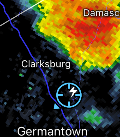
I just got a demonstration of how dangerous lightning can be. Just overcast here and not raining but had a lightning bolt out of nowhere followed by the thunderclap one second later. Here it is on RadarScope and the thunderstorm cell is a few miles to the northeast! That is how people get struck
-
7
-
 1
1
-
-
That's one storm I am GLAD missed me to the south. Look at the colors in that thing! I am not in a position to replace a bunch of windows in our house right now
-
1
-
-
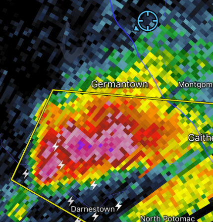
10 minutes ago, MN Transplant said:
Yeah, I hadn’t checked in a while. Been to 84.9 here!
And now we got some small thunderstorms rolling through. The one coming into western MontCo and aimed for Rockville looks strong
-
Wow wasn't expecting this hot today -- Dulles reporting 84 already
-
2 hours ago, PrinceFrederickWx said:
…I think I’m getting faint whiffs of a wildfire smell again?
Now that you bring that up -- I've been reading that Canada had a very warm and dry winter and some think that 2024 could be even a worse wildfire season than last year

As much as we love those cool, low humidity days after summer cold fronts, I'd rather take the big heat that comes with a SW flow if there are big fires burning up there
-
 1
1
-
-
Yeah that months-long period of 40s/50s with dreariness and bare, forlorn-looking trees and barely any snow most years is too much. I call it "The Dark" lasting from Nov. 1 to March 31 and am glad it's over. Although sometimes April can stink but next week's looking great
-
2
-
-
What a gorgeous afternoon - you can almost see the trees greening up
Next week is looking real good with late spring-like temps
-
2
-
-
Remains to be seen but it's nice to see 60s and 70s all the way thru the forecast period. Lot of rain later this week hopefully several dry days starting this weekend
May Discobs 2024
in Mid Atlantic
Posted
10 days into May tomorrow and we're looking at highs in the 50s. YUCK