

powderfreak
-
Posts
79,423 -
Joined
-
Last visited
Content Type
Profiles
Blogs
Forums
American Weather
Media Demo
Store
Gallery
Posts posted by powderfreak
-
-
You'd never know there was a path cleared and a deck 5' below that drift. 2/15 storm.
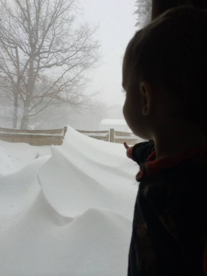
Great shot! Keep that one save on an external hard drive to show the boy when he's older.
In fact everyone should back up their photos from last winter, one crash on the computer and you can't get that back.
-
That radar sums up last winter, haha. Just pummeling eastern New England, especially Mass/BOS. Aimed right at BOS.The record breaker. Kind of a special event for me.
-
No, there's a feature on this forum called the "search function" and it can find older threads quickly. Then when you find a thread and associated images, there's a feature on the mouse called "right click" and you choose "copy image location" and then you return to this thread and click "paste" in the image url and those pictures will show up. It's pretty neat.

-
Haha I think that's hilarious...obviously once you get to the head in snow thrower sentence.
Suicide isn't a light topic but we talk about it everyday in this forum...rope and chair, jumping off bridges, etc...this is a new one though, head in snow blower.
-
Yes, very marginal setup on a coastal that was getting squashed a bit to the south:

Man that gradient from the CT River Valley to the immediate East Slope of the Berks is absolutely sick. 3-4" in the CT valley and 10-18" a few miles east into the hills. That upslope enhancement is pretty crazy because even some high elevation spots along the NY/MA border (west of the crest) don't have impressive totals at all. Then you can see the upslope again into the Catskills with 10"+ amounts showing back up. Its also evident in the ORH hills but not quite as drastic.
-
The 1/12 radar is definitely the best looking radar we've had in a long time...at the very least, since 12/9/05.
Yeah that is disgusting... and remember all the CT posters absolutely freaking out about that dryslot only to have it get absolutely shut down as it hit the coastline. That was amazing how that dry slot was crushed due east along the coast.
-
Weenie radar image from January 12, 2001 @ 3am.
2001 or 2011?
I remember being very jealous of that inflow band you guys were getting in SNE... but you were due for a widespread whopper like that.
-
The TV forecasts were awful
What did you end up with in that after all those 2-4" or 3-5" TV forecasts?
Up here I remember no one talking about that... I don't even think I was really paying attention until later that evening when I started seeing 1.5" QPF amounts showing up but still didn't believe it. Even that was a little low though as like NZucker I had around 20" of absolute tree breaking, power-out cement. I still remember trees down scattered all along RT 2 between Burlington and Waterbury. The evergreens took a beating in that storm.
-
fun reading the discussion before the storm
Thanks for posting that... that smoked a lot of folks in a very surprising way. There was no indication that much of the interior was going to get 1-2 feet and some higher terrain spots more. That was when the Catskills, Logan11, and Southern VT got like 5 feet in a couple days.
-
We got 20" of absolute cement in Middlebury VT from the 2/24 event, but the snowpack was devastated quickly by the heavy rain that followed in the 2/25 retrograde Snowicane.
Yeah that was a sick couple of days, even with the mixed crap that fell after the 24th... the summit of Mansfield had like 5-6" of liquid in a 72 hour period, with a net gain of 3 feet of snowpack. We got over 30" on the 23-24th (due to colder temps up high, better ratios, only 22-24" of cement down lower) followed by another 10" on the 25th then like 2" of freezing rain. It was like a storm cycle out of the Cascades or Sierra with tight snow levels and mixed precip but generally just a very moist flow.
-
I went through that whole thing on my free time. What great discos from Drag, both on and off the desk.
Haha, yeah if you want to kill a couple hours really quickly, spend some time reading through that stuff. I did that one night this past summer...just crack a cold one and live vicariously through the posts.
-
Check out the above link for EUSWX posts from the Blizz of 2005... there's some great stuff from Walt Drag in there.

New England snowstorm memories.
in New England
Posted
This will always be a favorite of mine just because it snowed 24" during Christmas Day. It was timed perfectly that it started early in the morning, and during Xmas morning activities it was just steady 1"/hr, though still not overly impressive until 3pm when it seemed to go crazy with 3-5" per hour rates. I just remember eating Christmas dinner and then finding like another half foot fell during that time. The whole family outside shoveling later at night as it continued to pour snow, on Christmas Day. Drove the grandparents home across town and couldn't stop at red lights as we'd never get rolling again. Blasting through snow banks that threw snow up the windshield and over the SUV as the road crews could only clear main roads, side streets had 12-18" since last plowing.
I'll always love knowing I got to experience a two-footer on Christmas Day. Not the day before or after...but right there on Dec 25th.