

MotoWeatherman
-
Posts
2,270 -
Joined
-
Last visited
Content Type
Profiles
Blogs
Forums
American Weather
Media Demo
Store
Gallery
Posts posted by MotoWeatherman
-
-
And flakes are flying here on Beech. Let the fun begin.
-
 6
6
-
-
Stoked for this event on Beech. I'm actually up here to witness this one.
-
2
-
-
I'm still feeling pretty good about a general 2-4 inches above 4000 ft.
-
1
-
-
Personal thinking is 2-4 inches for elevations above 4k. Starts probably before midnight Sunday night ending sometime on Tuesday.
If 850 temps were colder I would be more confident on higher amounts.
-
3
-
-
29 minutes ago, Buckethead said:
The overeating has already begun. It's my wife's fault for putting the pumpkin pie in the fridge last night lol. That stuff is irrestible cold!
Has anyone had a look at the ensembles? Can't really look right now, just wondering if they still aren't agreeing with the operational models on the nwf event Sun/Mon..
Happy Thanksgiving, y'all!
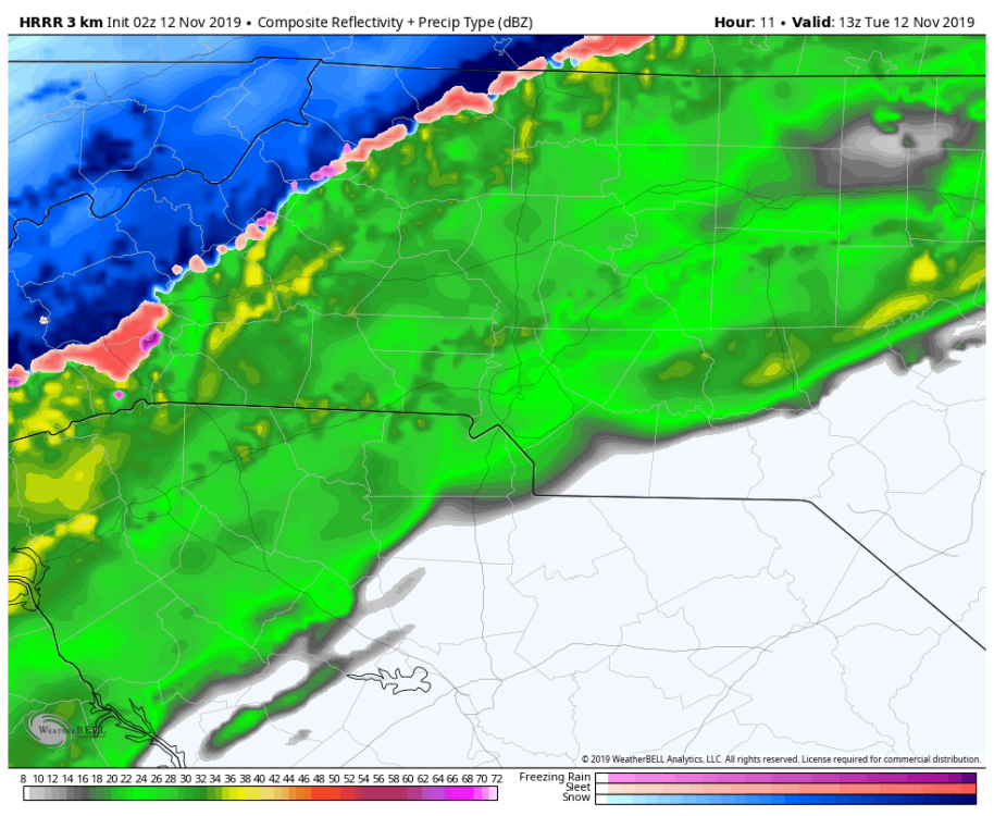
I'm not sure what you are referring to. Last 3 GEFS look great. As does the 12z operational. The synoptic features have wiggled a bit but the flow event still looks pretty much the same. Verbatim 12z GFS is 6-12 for elevations above 4k in my opinion.
-
1
-
-
Verbatim the 12z GFS is a 6-12 inch flow snow event Sunday night (Dec 1st) lasting through Monday. Long way to go before it gets here. EURO isn't nearly has robust but still has a multi inch event.
-
4
-
-
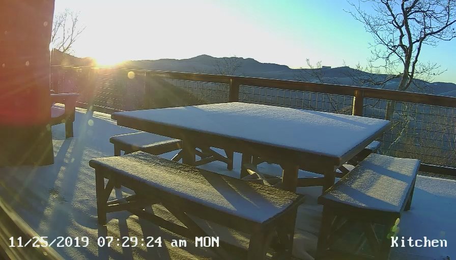
The last of my inch of snow will vanish today. Pic is sunrise today looking towards Grandfather Mtn Next opportunity is perhaps Sunday night into Monday.
-
1
-
-
Glad you made me revisit my post. I meant to say Saturday night/early Sunday for the snow showers. Not Sunday night. LOL. I've got my days mixed up. So snow showers are after midnight TONIGHT (SATURDAY NIGHT) lasting into the early day light hours.
-
1
-
 1
1
-
 1
1
-
-
1 hour ago, NGTim said:
Anything sat night on the back side of the rain?
Not in Dahlonega.
") Perhaps up to an inch in the NC mtns along the TN border above 3500 feet.
Perhaps up to an inch in the NC mtns along the TN border above 3500 feet.
-
1 hour ago, Buckethead said:
When you're originally from Columbia, SC, there is no such thing as a minor accumulation.
True
-
Looks like another round of high elevation show showers is in order late Sunday night/early Monday AM. Locations near the TN line should expect minor accumulations.
-
1
-
-
Well that was a nice surprise. Ended up with half an inch of snow that is not all gone. LOL.
That makes my 4th time seeing flakes and 3rd time getting accumulating amounts. 2.25" so far this season.
-
4
-
-
Solid dusting here on Beech with flakes flying
-
4
-
-
11.4 at 4650 on Beech. Just about 1000 feet higher it's 7 on top of Beech. Frigid!
-
2
-
-
Solid flakes still flying here on Beech. Frigid temp down to 11.6.
-
35 minutes ago, Tyler Penland said:
Been flurrying at least all day on the TN line in elk park. Bout an inch or so on the grass. My parking lot is half ice ha.
Is the Elk Park store now your working location?
-
Pouring snow here on Beech. Down to 27.6.
So far the HRRR was spot on with timing.
-
4
-
-
36 minutes ago, Iceagewhereartthou said:
If that's accurate someone's going to see a nice event. Must be nice not to be on the lee side!
I've found the HRRR to be pretty decent on this type of stuff in this short of a range (ie less than 12 hours out)
And yeah ..TN line locations will do best with this type of setup.
-
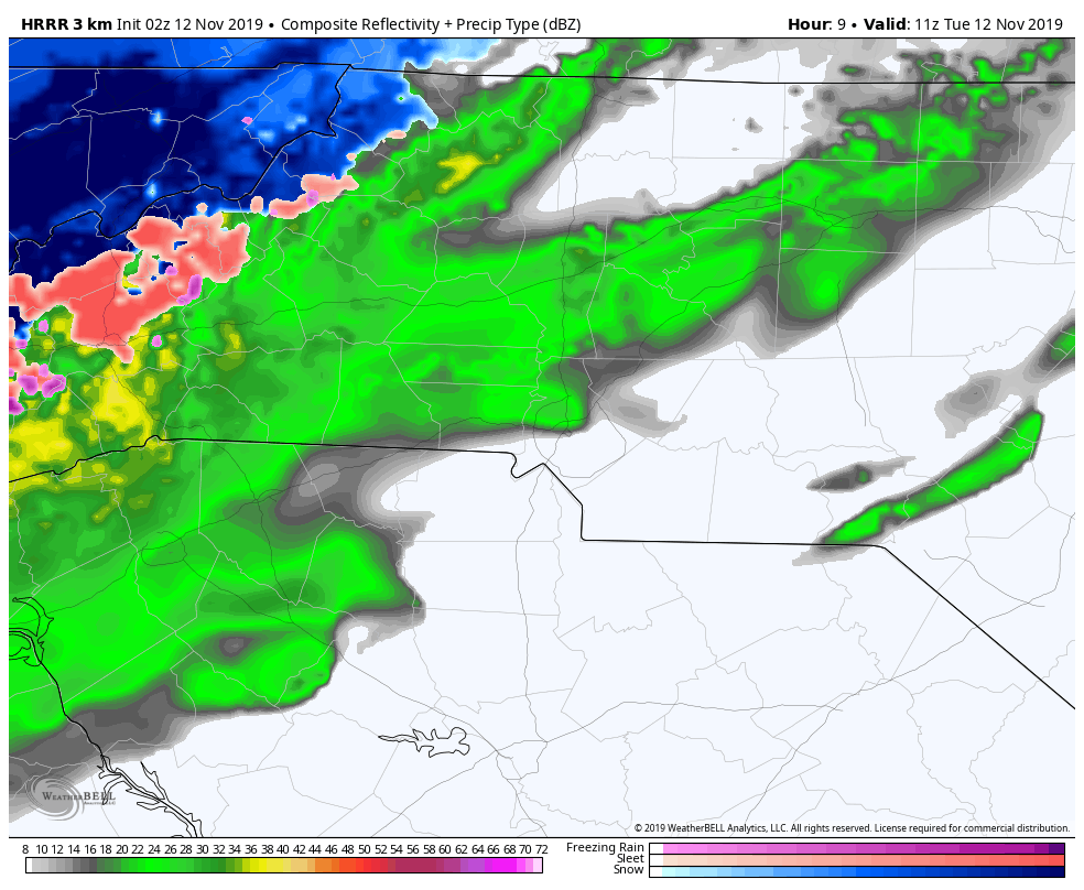
HRRR has been rock solid consistent in showing flip to snow along the TN border areas of NC by 6am with a rapid change over to the border counties by 9am. Then it's a quick few hours of snow before the flow sets up for the high peaks the rest of the day.

-
3
-
-
Got another dusting of snow here at 4650 on Beech. Sun is coming out now.
-
2
-
-
28.9 with a coating on the ground here at 4650 on Beech.
-
1
-
-
Light snow here on Beech. 2nd flakes of the season. Temp is 32. Yes!!!
-
4
-
-
Finally pouring snow at 4650 on Beech. Ground is starting to turn white just a bit. But temp is still 33.8.
-
1
-
-
Flakes flying at 4650 on Beech.
-
4
-

2019/2020 Mountains and Foothills Fall/Winter Thread.
in Southeastern States
Posted
Pretty much same here on Beech. Our best snow is supposed to happen today. Unfortunately my original 2-4 inch forecast might verify for us. Not happy about that. Lol