MotoWeatherman
-
Posts
2,292 -
Joined
-
Last visited
Content Type
Profiles
Blogs
Forums
American Weather
Media Demo
Store
Gallery
Everything posted by MotoWeatherman
-

2019/2020 Mountains and Foothills Fall/Winter Thread.
MotoWeatherman replied to Tyler Penland's topic in Southeastern States
Good luck to all tomorrow. I'll be living this one out in Dahlonega GA but checking my cams on Beech. -
2019/2020 Mountains and Foothills Fall/Winter Thread.
MotoWeatherman replied to Tyler Penland's topic in Southeastern States
Covered again and coming down decent. Lol Cam_East-213521-213529.mp4 -
2019/2020 Mountains and Foothills Fall/Winter Thread.
MotoWeatherman replied to Tyler Penland's topic in Southeastern States
Nice. Here over on Beech at 4650. Not trying to be a party pooper but the 3k NAM often overdoes NW flow type snow events. -
2019/2020 Mountains and Foothills Fall/Winter Thread.
MotoWeatherman replied to Tyler Penland's topic in Southeastern States
Grandfather Mountain poking thru the clouds right before sunset.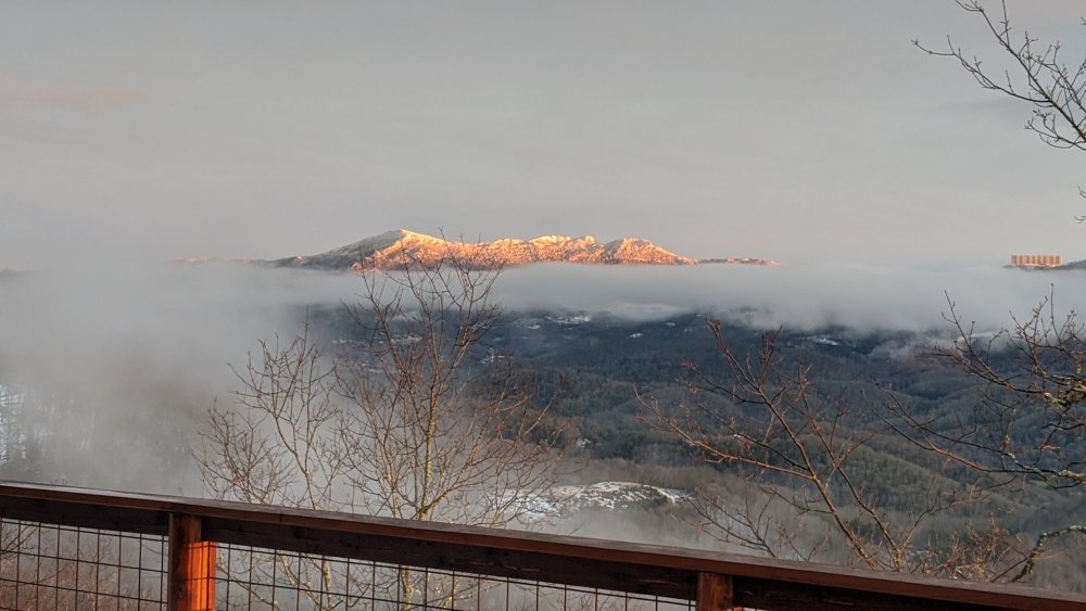
-
2019/2020 Mountains and Foothills Fall/Winter Thread.
MotoWeatherman replied to Tyler Penland's topic in Southeastern States
For your area maybe half inch in thinking. 1-2 for the northern mtns. Hope I'm wrong though and you get more. -
2019/2020 Mountains and Foothills Fall/Winter Thread.
MotoWeatherman replied to Tyler Penland's topic in Southeastern States
Rain? Where? -
2019/2020 Mountains and Foothills Fall/Winter Thread.
MotoWeatherman replied to Tyler Penland's topic in Southeastern States
If the NAM holds within 24 hours of an event, it's usually on to something the globals are missing. -
2019/2020 Mountains and Foothills Fall/Winter Thread.
MotoWeatherman replied to Tyler Penland's topic in Southeastern States
Latest HRRR for around 11am showing decent activity in the mountains. I personally like using the HRRR if it's within a 6 hour time frame.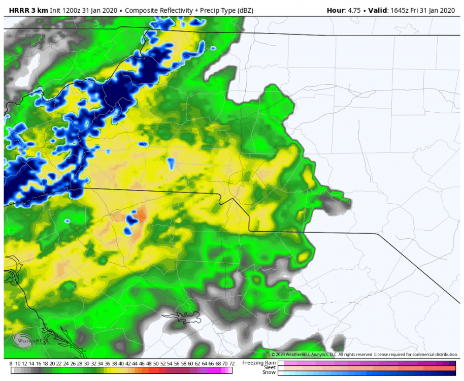
-
2019/2020 Mountains and Foothills Fall/Winter Thread.
MotoWeatherman replied to Tyler Penland's topic in Southeastern States
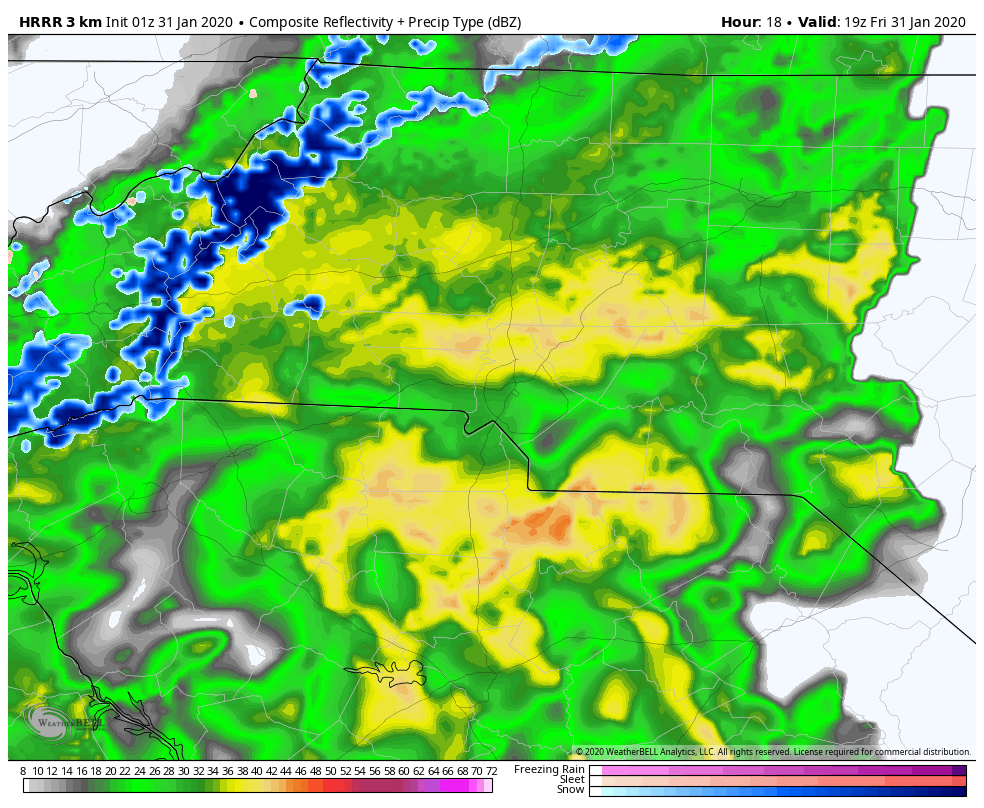
HRRR still looking decent for higher elevations tomorrow. Latest run tweaks precip west a bit. This is 1z run.
-
2019/2020 Mountains and Foothills Fall/Winter Thread.
MotoWeatherman replied to Tyler Penland's topic in Southeastern States
Snowing at a decent rate here on Beech. Temp is below freezing and the ground was still covered from the other day. Cam_West-222348-222357.mp4 -
2019/2020 Mountains and Foothills Fall/Winter Thread.
MotoWeatherman replied to Tyler Penland's topic in Southeastern States
Meanwhile the 0z Euro is a complete whiff to the South. Lol -
2019/2020 Mountains and Foothills Fall/Winter Thread.
MotoWeatherman replied to Tyler Penland's topic in Southeastern States
Still coming down at a good clip tonight. Smallest of streamers on the GSP radar right on top of me. Lol Cam_West-232152-232157.mp4 -
2019/2020 Mountains and Foothills Fall/Winter Thread.
MotoWeatherman replied to Tyler Penland's topic in Southeastern States
Just flakes flying. Nothing on the ground. Got about 2 inches at 4650 on Beech. -
2019/2020 Mountains and Foothills Fall/Winter Thread.
MotoWeatherman replied to Tyler Penland's topic in Southeastern States
Lol. And Boone will probably strike out again due to temps. I think you will have to climb above 4k feet to see the 2-3inch amounts. -
2019/2020 Mountains and Foothills Fall/Winter Thread.
MotoWeatherman replied to Tyler Penland's topic in Southeastern States
Surprised no one is talking about tomorrow (Monday). Both NAM and GFS really juiced up the northern MTN with a solid 1-3 inches. -
2019/2020 Mountains and Foothills Fall/Winter Thread.
MotoWeatherman replied to Tyler Penland's topic in Southeastern States
Totally dumping here on Beech. -
2019/2020 Mountains and Foothills Fall/Winter Thread.
MotoWeatherman replied to Tyler Penland's topic in Southeastern States
If everything goes as planned that heavier batch moving in from TN should turn back to snow and end as snow before it all moves out sometime after 3pm. -
2019/2020 Mountains and Foothills Fall/Winter Thread.
MotoWeatherman replied to Tyler Penland's topic in Southeastern States
26 and almost an inch already here at 4650 on Beech Mtn. Made it up for this deal. -
2019/2020 Mountains and Foothills Fall/Winter Thread.
MotoWeatherman replied to Tyler Penland's topic in Southeastern States
So far at least a half inch here at 4650 on Beech. Maybe we can eek out an inch. -
2019/2020 Mountains and Foothills Fall/Winter Thread.
MotoWeatherman replied to Tyler Penland's topic in Southeastern States
29.6 here on Beech with snow flying and the ground covered. -
2019/2020 Mountains and Foothills Fall/Winter Thread.
MotoWeatherman replied to Tyler Penland's topic in Southeastern States
Same here on Beech. Starting to stick. -
2019/2020 Mountains and Foothills Fall/Winter Thread.
MotoWeatherman replied to Tyler Penland's topic in Southeastern States
Easily my best snow rates yet. Coming down at a good clip with nickel size flakes. Radar looks good to our north as that next batch of moisture moves south out of VA. 850s will cool throughout the day which should increase snow efficiency and we get rid of the less than ideal conditions for flake production with low level moisture. -
2019/2020 Mountains and Foothills Fall/Winter Thread.
MotoWeatherman replied to Tyler Penland's topic in Southeastern States
Pretty much same here on Beech. Our best snow is supposed to happen today. Unfortunately my original 2-4 inch forecast might verify for us. Not happy about that. Lol -
2019/2020 Mountains and Foothills Fall/Winter Thread.
MotoWeatherman replied to Tyler Penland's topic in Southeastern States
And flakes are flying here on Beech. Let the fun begin. -
2019/2020 Mountains and Foothills Fall/Winter Thread.
MotoWeatherman replied to Tyler Penland's topic in Southeastern States
Stoked for this event on Beech. I'm actually up here to witness this one.