HighTechEE
-
Posts
567 -
Joined
-
Last visited
Content Type
Profiles
Blogs
Forums
American Weather
Media Demo
Store
Gallery
Everything posted by HighTechEE
-
Let’s talk winter!! Ohio and surrounding states!!
HighTechEE replied to Steve's topic in Lakes/Ohio Valley
Whoa! Jan 6th and I got 1/4 of a skiff of the 1st synaptic snow of the entire season (a skiff I think is a few flakes deep acording to how my dad viewed it)!!! Also its been exactly 10 years since we've had a real winter here in S. Ohio! Maybe this is a hint... -
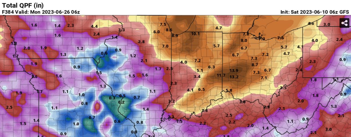
Hi All, was too busy to post thsi yesterday, but the 06z GFS yesterday morning had a monster glitch in the matrix where it had 15"+ for SW Ohio/Dayton area for the next 16 days! Not sure I've ever seen a model screw up this bad! The last time I had a day of 1" of rain or more was mid-April, and nothing over a half inch since May 7. So on pins and needles today with ILN's 1" to 1.5" in the forcast with later this afternoon and evening that my Kentucky Brown Grass desperately needs (and so my wife will stop bellyaching about me watering so much), I'm like I'm only keeping it alive, I haven't mowed in 3 1/2 weeks!

-
I'm at 17.25" of snow total IMBY so far this winter, my gut feeling that may double in one event, in April!
-
And poof less than 24hrs later, gone...
-
Well the fat lady hasn't sung yet according to the 12z GFS, thats over a foot of snow for KDAY and all of southern Ohio next Friday/Sat with the bulk of the precip surface temps below freezing and the 850s way under! 192 Fri 03/17 12Z 33.2 35.7 32.5 25.8 WNW 7 NW 20 NW 24 0.00" 0.00" 540 554 -17.2 -0.9 -2.2 1018.0 99.4 -0.1 -33° 0.1 195 Fri 03/17 15Z 33.5 34.5 32.7 24.5 NW 6 NW 9 WNW 14 0.01" 0.62 0.00" 539 554 -17.5 -1.3 -3.7 1018.4 100.0 0.1 -33° 98.3 198 Fri 03/17 18Z 36.5 36.7 32.8 26.0 NW 4 NW 5 WNW 8 0.01" 0.63 0.00" 538 553 -17.5 -2.0 -2.9 1017.6 100.0 0.1 -31° 204.4 201 Fri 03/17 21Z 36.2 37.2 36.0 27.2 NNE 5 NNE 8 NNE 4 0.02" 0.65 0.00" 538 550 -18.7 -2.7 -2.5 1015.2 100.0 -0.3 -17° 241.0 204 Sat 03/18 00Z 33.4 37.2 33.4 29.5 NE 8 NE 18 NE 19 0.03" 0.68 0.00" 538 549 -17.7 -5.8 -2.8 1012.9 100.0 -0.5 -10° 151.7 207 Sat 03/18 03Z 31.4 33.3 31.3 30.5 NNE 12 NNE 28 NE 30 0.31" 0.99 0.00" 538 547 -16.6 -6.6 -3.3 1010.1 100.0 -1.7 -7° 0.0 210 Sat 03/18 06Z 30.0 33.3 30.0 29.1 NNE 16 NNE 34 NE 34 0.42" 1.41 0.00" 538 543 -17.7 -6.8 -3.7 1006.9 100.0 -0.1 -7° 0.0 213 Sat 03/18 09Z 27.1 30.0 27.1 25.7 NNW 18 N 38 NNE 35 0.10" 1.51 0.00" 534 539 -19.6 -7.8 -5.1 1005.1 99.5 -0.4 -9° 0.0 216 Sat 03/18 12Z 25.5 30.0 25.5 24.0 NNW 15 NNW 33 NNE 32 0.02" 1.53 0.00" 531 535 -21.7 -8.0 -6.0 1005.6 100.0 -0.2 -9° 0.3 219 Sat 03/18 15Z 27.5 27.5 25.5 26.4 NW 16 NW 31 NNW 26 0.04" 1.57 0.00" 526 531 -27.9 -8.5 -6.0 1006.8 100.0 0.1 -9° 168.6 222 Sat 03/18 18Z 30.1 30.0 25.4 29.4 WNW 16 NW 27 NW 27 0.03" 1.60 0.00" 522 527 -31.2 -9.2 -4.9 1006.6 100.0 -0.2 -10° 347.3 225 Sat 03/18 21Z 29.2 30.2 29.1 27.6 WNW 19 WNW 36 WNW 35 0.03" 1.63 0.01" 519 525 -32.7 -9.7 -5.3 1006.8 100.0 -0.4 -10° 485.6 228 Sun 03/19 00Z 27.8 30.2 27.8 26.7 W 18 WNW 39 NW 42 0.04" 1.67 0.00" 518 525 -32.8 -8.8 -5.0 1007.9 100.0 -0.5 -9° 301.3 231 Sun 03/19 03Z 26.6 28.0 26.4 25.4 WNW 14 NW 29 NW 31 0.04" 1.71 0.00" 518 526 -32.6 -10.3 -5.8 1009.8 99.8 0.0 -11° 0.0 234 Sun 03/19 06Z 23.7 28.0 23.7 21.5 NW 14 NW 31 NW 33 0.02" 1.73 0.00" 518 527 -32.4 -11.7 -7.6 1011.8 97.7 0.1 -12° 0.0
-
Yes and 12z the GFS has moved it 200 miles further north with nothing but heavy rain again for Ohio.
-
Yesterday's 18z GFS had 38" for the Findlay area, and lowered my SE side of Dayton to a couple inches for this coming Friday, this morning's 06z run shifted everything to a line from central Illinoise to Toledo with 2ft+ with nothing IMBY.
-
Yay a foot to a foot & a half for I-71 again, what's the modeled eye candy up to now this winter that never fell, a 100 inches maybe after next weekend!
-
00z & 06z GFS has the Three C highway in Ohio getting a foot of snow next Sat the 11th, yeeeeaaaa right
-
Nothing like heavy rain on a winter morning, snowed IMBY from 2am to 7am on the SE side of Dayton, had a little over 3" around 5am and was washded down to a little over an inch by 9am.
-
Well boys and girls if this is going to hold on for the I-71 corridor we're going to need low dew points to start and the column cooling like the Sunday storm? very rare for repeat storms like this in our neck of the woods!
-
Yes they had them first thing this morning but north & west of Dayton, now it is north & west of I-71 roughly one more county SE from this morning.
-
ILN just addded another SE teir of counties in the WSWatch.
-
Nooo! 12z models hopefully track this next system tmar night over SE Ohio, if it goes anywhere near SW Ohio the entire I-71 coridor & those SE of that will be screwed. I missed yesterday's snow driving back in it coming home from the Hocking Hills Anuall Winter Hike with no snow there on Saturday and no ice formations AGAIN! Took me 3hrs to make a normal 1hr35mins trip. Not sure how much snow fell IMBY as by the time I made it home here on the SE side of Dayton it looked like there were many hours of temps at 33 and it was melting from the bottom up as well. I did measure just under 5" on the ground and just over 5" on elavated surfaces. iluvsnow lives one mile west of me and he measured 7" so looking at ILN's obs 5 to 7" near me would be a good educated guess. Fingers crossed for the next system!
-
Welp, I just put my snow blower away for the season, used it once, AGAIN!
-
12z GFS dumps a half foot on SE Indiana/SW Ohio this Sat, like that will happen
-
Just saw where the OU airport (KUNI) in Athens in SW Ohio recorded thundersnow at 4am this morning!
-
-9 degrees out IMBY! We're only 4 degrees from the infamous -13 below during the '83 Christmas Eve/Day artic blast! Guessing close to 4" of snow total here in SW Greene Co. And they are saying the really high winds will not get here until this afternoon!
-
Just woke up and they grass is covered IMBY, so at least 3" has fell and still snowing hard. Could end up with about 4" total w/o actually measuring (and it's down to 1 degree!).
-
28 now IMBY with heavy snow.
-
First flakes IMBY now, 37 degrees. The heavy snow only looks like 1 county wide, so maybe 1 inch total here, then pixie dust the rest of the night.
-
its extremely rare that I post this, but IMBY the temp & pressure is falling rapidly! Still no snow yet at 39 degrees.
-
Cold front just west of KDAY, snow is on the Ohio/Indiana border!
-
Yea these runs with the high vs low accumes across Ohio is very odd. 18z NAM has about 5" IMBY in SW Greene Co. where GFS has 10"?
-
Next to nothing outside the Olentangy and Sciota rivers we're screwed!