

Juliancolton
-
Posts
8,522 -
Joined
Content Type
Profiles
Blogs
Forums
American Weather
Media Demo
Store
Gallery
Everything posted by Juliancolton
-

The Hudson Valley Thread
Juliancolton replied to IrishRob17's topic in Upstate New York/Pennsylvania
That sucks; I hope everything works out for you guys. 23F here, warming very very gradually. -
The Hudson Valley Thread
Juliancolton replied to IrishRob17's topic in Upstate New York/Pennsylvania
Gotta make people work for it. Thanks! -
The Hudson Valley Thread
Juliancolton replied to IrishRob17's topic in Upstate New York/Pennsylvania
–5F again this morning at Dutchess County Airport. I got some pictures of the Hudson River completely frozen over that I posted in the relevant thread, if anyone's seen it (in the NYC forum). -
The Hudson Valley Thread
Juliancolton replied to IrishRob17's topic in Upstate New York/Pennsylvania
This is getting old. –5 here at Dutchess County Airport this morning at about 6 am. -
The Hudson Valley Thread
Juliancolton replied to IrishRob17's topic in Upstate New York/Pennsylvania
I'm gonna call it 14" here in eastern Dutchess. Amazingly quick dump... I went to bed at 11:30 and it was just starting, and the radar was nearly dry by the time I got up at 8:45. -
The Hudson Valley Thread
Juliancolton replied to IrishRob17's topic in Upstate New York/Pennsylvania
The difference is Bloomburg isn't running for reelection, whereas the Feb 1969 storm put a good dent in Lindsey's political career. -
The Hudson Valley Thread
Juliancolton replied to IrishRob17's topic in Upstate New York/Pennsylvania
As was expected, it's impossible to get an accurate measurement. Drifts as high as me in some areas of the yard and bare ground in others. If I had to guess, I'd say around 13" of total accumulation. The gusts last night were the strongest synoptic winds I've ever seen, so overall this was a worthwhile storm to track for so long. Right after the storm this morning, as the sky was just beginning to break, I was pleasantly surprised by the appearance of a Kelvin–Helmholtz cloud. -
The Hudson Valley Thread
Juliancolton replied to IrishRob17's topic in Upstate New York/Pennsylvania
Currently lighting up for me... what radar are you using? -
The Hudson Valley Thread
Juliancolton replied to IrishRob17's topic in Upstate New York/Pennsylvania
In fairness, a good portion of this has probably already fallen, given that 0z is 7pm EST. -
The Hudson Valley Thread
Juliancolton replied to IrishRob17's topic in Upstate New York/Pennsylvania
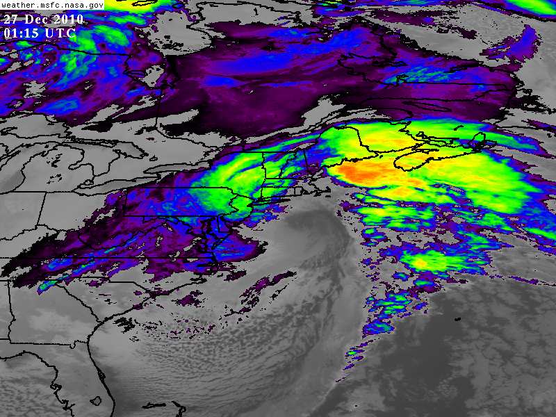
Really intense echos setting up over the entire area. Not going anywhere fast either. -
The Hudson Valley Thread
Juliancolton replied to IrishRob17's topic in Upstate New York/Pennsylvania
-
The Hudson Valley Thread
Juliancolton replied to IrishRob17's topic in Upstate New York/Pennsylvania
Nice! Might have to drive out to your area tomorrow to check it out. -
The Hudson Valley Thread
Juliancolton replied to IrishRob17's topic in Upstate New York/Pennsylvania
6"+ here with blizzard conditions. -
The Hudson Valley Thread
Juliancolton replied to IrishRob17's topic in Upstate New York/Pennsylvania
So far it's just a few miles too far west for me to stay in perpetuated high snowfall rates, but it's still early. I wonder if that band coming into eastern Dutchess County is going to tack onto the main band over you and build it eastward. -
The Hudson Valley Thread
Juliancolton replied to IrishRob17's topic in Upstate New York/Pennsylvania
Updated forecast for Lake Carmel calls for "Total nighttime snow accumulation of 17 to 23 inches possible". Meep... -
The Hudson Valley Thread
Juliancolton replied to IrishRob17's topic in Upstate New York/Pennsylvania
Extrapolate northward and... -
The Hudson Valley Thread
Juliancolton replied to IrishRob17's topic in Upstate New York/Pennsylvania
That band coming NW through Pawling should be even better than the last one. That MD from Norman looks encouraging. -
The Hudson Valley Thread
Juliancolton replied to IrishRob17's topic in Upstate New York/Pennsylvania
Think thundersnow is a realistic plausibility for the MHV? -
The Hudson Valley Thread
Juliancolton replied to IrishRob17's topic in Upstate New York/Pennsylvania
Near Millbrook in Dutchess County... about 15 miles due east of POU. -
The Hudson Valley Thread
Juliancolton replied to IrishRob17's topic in Upstate New York/Pennsylvania
Sure enough, that band is just sitting over me and intensifying. Some of the most intense snowfall rates I've ever seen... approaching 3". -
The Hudson Valley Thread
Juliancolton replied to IrishRob17's topic in Upstate New York/Pennsylvania
Seconded (or I guess thirded at this point). -
The Hudson Valley Thread
Juliancolton replied to IrishRob17's topic in Upstate New York/Pennsylvania
What's the composition of the snow out by you? -
The Hudson Valley Thread
Juliancolton replied to IrishRob17's topic in Upstate New York/Pennsylvania
NWS Albany upped my snowfall totals a little and added the possibility for thundersnow. Now 12–20" overall. -
The Hudson Valley Thread
Juliancolton replied to IrishRob17's topic in Upstate New York/Pennsylvania
RUC keeps the heavy banding largely south of us... -
The Hudson Valley Thread
Juliancolton replied to IrishRob17's topic in Upstate New York/Pennsylvania
Same here. Been snowing little pingers for a few hours (though they're now starting to transition into real flakes) and very little accumulation so far.