Juliancolton
-
Posts
8,594 -
Joined
Content Type
Profiles
Blogs
Forums
American Weather
Media Demo
Store
Gallery
Everything posted by Juliancolton
-
Hard drive crash? Either way, that looks truly awesome.
-
Yeah? Wow, I didn't realize that. I only had a passing interest back then, so I don't think I spent more than a few moments looking upward for that one. It's pretty incredible to read the accounts of zenithal coronas over Chicago and NYC in 1859, 1882, etc., knowing how difficult it is to even see diffuse greens on the horizon. I got lazy and hooked my camera up to an intervalometer for some warmup time indoors. Will check again in a bit.
-
Very faint green curtain structure on my LCD. After years of trying to catch the odd spike to Kp 7, I'm not sure what I expected hours and hours of Kp 8 to look like, but it sure wasn't this. lol
-
My camera sensor is seeing increasingly funky colors on the northern horizon. Going to stay on the lookout for a substorm. Sure is cold and blustery though... quite conducive to aurora chasing.
-
Bz straddling neutral now. Congrats Iqaluit.
-
Ugh... it literally never fails. Almost sickening if it started getting meh right as dark falls after looking so good all day. At least the other parameters still look decent.
-
Wing Kp model back up and predicting Kp 9 in four hours. Good good.
-
The storming has sustained itself better than I expected it would. Kp 7 into this evening would be more than acceptable.
-
The Wing Kp data has been missing for several hours per http://services.swpc.noaa.gov/text/wing-kp.txt. Not sure what's up with that.
-
-
-

Tornados count relationship to hurricanes in NC
Juliancolton replied to downeastnc's topic in Southeastern States
How can you have any idea what the storm will be like? -
I have a geological newbie question–what would cause an earthquake to be felt in a residential building on one street (and not just "felt", but seriously shaken up), but not even a noticeable tremor on the next street? The obvious answer is that it has something to do with the underlying rock formations, but I'd like to know specifically if elevation, etc. has anything to do with it. FWIW I'm about 75 miles north of NYC.
-
The Hudson Valley Thread
Juliancolton replied to IrishRob17's topic in Upstate New York/Pennsylvania
-8 this morning at KPOU (don't know if that's been mentioned yet) and expected to get even colder tonight. -
The Hudson Valley Thread
Juliancolton replied to IrishRob17's topic in Upstate New York/Pennsylvania
That sucks; I hope everything works out for you guys. 23F here, warming very very gradually. -
The Hudson Valley Thread
Juliancolton replied to IrishRob17's topic in Upstate New York/Pennsylvania
Gotta make people work for it. Thanks! -
The Hudson Valley Thread
Juliancolton replied to IrishRob17's topic in Upstate New York/Pennsylvania
–5F again this morning at Dutchess County Airport. I got some pictures of the Hudson River completely frozen over that I posted in the relevant thread, if anyone's seen it (in the NYC forum). -
The Hudson Valley Thread
Juliancolton replied to IrishRob17's topic in Upstate New York/Pennsylvania
This is getting old. –5 here at Dutchess County Airport this morning at about 6 am. -
The Hudson Valley Thread
Juliancolton replied to IrishRob17's topic in Upstate New York/Pennsylvania
I'm gonna call it 14" here in eastern Dutchess. Amazingly quick dump... I went to bed at 11:30 and it was just starting, and the radar was nearly dry by the time I got up at 8:45. -
The Hudson Valley Thread
Juliancolton replied to IrishRob17's topic in Upstate New York/Pennsylvania
The difference is Bloomburg isn't running for reelection, whereas the Feb 1969 storm put a good dent in Lindsey's political career. -
The Hudson Valley Thread
Juliancolton replied to IrishRob17's topic in Upstate New York/Pennsylvania
As was expected, it's impossible to get an accurate measurement. Drifts as high as me in some areas of the yard and bare ground in others. If I had to guess, I'd say around 13" of total accumulation. The gusts last night were the strongest synoptic winds I've ever seen, so overall this was a worthwhile storm to track for so long. Right after the storm this morning, as the sky was just beginning to break, I was pleasantly surprised by the appearance of a Kelvin–Helmholtz cloud. -
The Hudson Valley Thread
Juliancolton replied to IrishRob17's topic in Upstate New York/Pennsylvania
Currently lighting up for me... what radar are you using? -
The Hudson Valley Thread
Juliancolton replied to IrishRob17's topic in Upstate New York/Pennsylvania
In fairness, a good portion of this has probably already fallen, given that 0z is 7pm EST. -
The Hudson Valley Thread
Juliancolton replied to IrishRob17's topic in Upstate New York/Pennsylvania
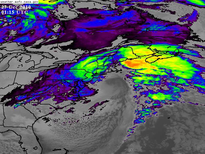
Really intense echos setting up over the entire area. Not going anywhere fast either. -
The Hudson Valley Thread
Juliancolton replied to IrishRob17's topic in Upstate New York/Pennsylvania