

CoastalWx
-
Posts
176,100 -
Joined
-
Last visited
Content Type
Profiles
Blogs
Forums
American Weather
Media Demo
Store
Gallery
Everything posted by CoastalWx
-
WTTTE
-
He's NH for life. I picture Brian to start shaking uncontrollably when crossing the border on 93.
-
You'll get some action.
-
.29" here. Not bad.
-
They had sun since June, but you chose the worst stretch since Memorial Day. Congrats.
-
Congrats white marble mines of VT.
-
What's funny?
-
It either doesn’t rain on the Cape, or it’s 6”/hr. Lol.
-
Congrats ern NY into adjacent MA and VT/NH.
-
Globals aren't too excited about that one yet.
-
Good thing Wiz tracked this for 7 days.
-
That’s more like I-95
-
EPS is not like the op.
-
Tuesday-Wednesday (maybe Thursday). Euro op hot actually Wednesday, but who knows this far out.
-
LOL not really. GFS troughy too, but the EPS isn't like that. Maybe a couple days 80s with dews.
-
Tip the graphic I posted is different then what you described. The description is actually below the chart.
-
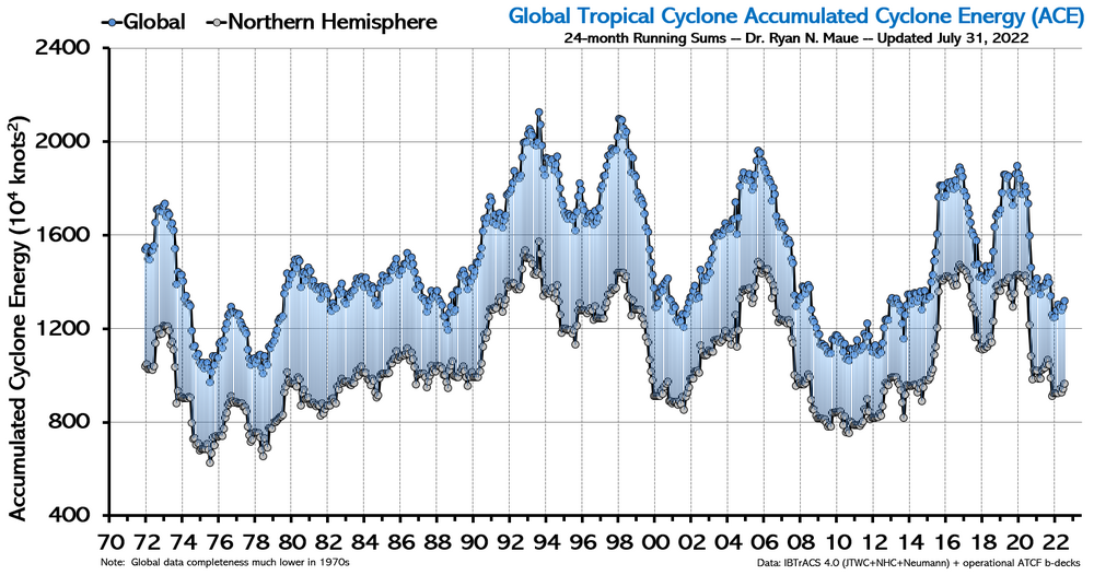
Oh it's from here--> https://climatlas.com/tropical/
-
We glee for cold and snow in winter .
-
Don’t look up!
-
After today, ready for pumpkin spice and a 8-9 season lol.
-
It could be a cycle thing as you see in the graph in earlier years. However, with global SSTs as warm as they are, it’s worth watching.
-
Pretty colors?
-
I am. Days and days of 80s?
-
I don’t see 80s for days. It’s over.
-
Maybe 78-82 that Sunday? Lol.


