

Animal
-
Posts
6,320 -
Joined
-
Last visited
Content Type
Profiles
Blogs
Forums
American Weather
Media Demo
Store
Gallery
Posts posted by Animal
-
-
Lots of trees down on the ridge line in highland lakes. Seen a few homes in bad shape due to trees. No power
-
1 minute ago, sussexcountyobs said:
As of 1 minute ago 1.91" in Cliffwood Lake
What are you using to measure rain with?
-
Just now, NJwx85 said:

I have barely an inch.
that shows over 2 inches in my area
-
2 minutes ago, sussexcountyobs said:
1.00" of rain so far. Wind ENE @ 5mph
Crushing me.
only 0.70 of rain
interesting aspect is radar indicates very heavy rain...just not seeing it.
wind blowing decent
-
8 minutes ago, Rtd208 said:
A couple of showers and a minor breeze.
More cloudy and mist here.
not impressed
-
29 minutes ago, Stormlover74 said:
Many places may end up with more from last nights storms than from today
My forecast is for almost 4 inches of rain....sort smells of rain outside!!
-
Most recent hrrr run has most of heaviest rain falling in Pennsylvania
-
Mt Holly nws 230 am afd update is very ominous
-
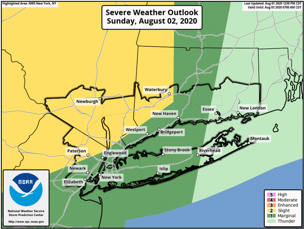
Tornado watch Sussex, Passaic & Bergen counties
-
57 minutes ago, TriPol said:
Too early to call today a bust?
No watch issued & Mt Holly nws is on the fence if anything severe develops
-
Pouring rain here
-
14 minutes ago, SACRUS said:
Newark with the southern wind capping at 88 today. Clouds and storms look numerous tomorrow, already showers into EPA. Monday may be the next shot at 90s ahead of Isaias with 850 temps near 20C.
Per Walt drag. Temps teach near 100 this morning south areas.
-
59 minutes ago, Stormlover74 said:
Yea wondering about tomorrow. Walt Drag’s post this morning was rather startling
-
1 hour ago, wdrag said:
Good Saturday morning everyone, Little change from what was posted yesterday and possibly my last post until Sunday morning.At that time, I may start a separate SVR topic for Sunday alone. Need more time to evaluate but SVR is likely for at least a few locations in our forum Sunday.
On SVR: big CAPE of 3000J, HI near 100 PHL feeding the storms, decent wind aloft with only worry a little drop of the KI during the afternoon. Nevertheless, this could be a 2 or 3 SVR episode day. The first, northeastward moving storms during the morning with WAA, the second in the afternoon (still northeast moving), and the third a final trough passage line from west to east between 5 and 10PM. Eastern LI may be completely shut out of this. Primary threat region is far w CT-NYC all NJ se NYS and ne PA. Please follow local office and SPC guidance discussions.
Thereafter a PRE is possible ~ a DCA-POU axis Monday night followed by squally excessive rain producing Isaias Tuesday afternoon-night.
More details on possible impacts below. This does not include power outages but will add concerns on that tomorrow if still possible (SVR Sunday and Isaias squalls Tuesday)
1) Potential killer Rip Currents Monday-Wednesday for anyone who ventures into the waters s of LI. I'd be wary of swimming, especially non expert surfers/non expert swimmers. The significant undercurrent 1 feet 15 second swell may start arriving this weekend. These long period subtle swells surprise swimmers with their energy and are sneaky dangerous. The higher surf just preceding and following the storm (within 18 hours) usually scares off most swimmers.
2) Rainfall as per multiple ensembles and WPC guidance. My impression is that between 1AM Sunday and 1AM Wednesday, a few locations will see ~5-7" rainfall, with isolated (1 location) 10" amount not impossible. My guess is heaviest is NJ, se NYS, w CT... presuming track continues as modeled through 06z/1. To the right of Isaias, squally and less rain, possibly less than 1" total extreme eastern LI if Isaias tracks west of Montauk.
3) Per NHC 5AM Saturday 8/1 track: surge and wind field risks on the western side of ISAIAS are minimal but if the track shifts to where a portion of our area is on the eastern side of the TC, then those risks would significantly increase. I think eastern LI to the southeast New England coast are vulnerable for at least some of these stormier impacts. Preparation should continue for that...ie gusts 50 knot.
4) PRE: Composites posted yesterday. Where this PRE occurs, IF it occurs, is unknown but my best guess now is on an axis from vicinity DCA-POU Monday night based on 00z/1 modeling. Still could end up further north, again if it occurs. Not a CLASSIC PRE (need a little more se low level inflo than currently modeled) but hints are in the qpf modeling. Need to look a lot closer at guidance details and surface wind shift axis on Monday. Just too early to be sure of occurrence and if so, where. I'm thinking it will but I don't know where. These 6-12 hour events can be easy 4-8" producers in 6-12 hours. I'm looking for narrow slices of darker or even brightly colored heavier QPF in the modeling 12-24 hours in advance of Isaias in the GFS/EC/GGEM. If we get to 36 hours and it's still possible, then we shift to the NAM and HRRR SPC HREF.
636A/1
Sorta of alarming with your post regarding tomorrow.
-
Threat looks done
-
-
Heading to Portland, Maine
some good new growth trees in nnj

-
In my area...it will struggle to see rain.
you get this every now and again.
-
Looks like a bust
-
 1
1
-
-
1 hour ago, Brian5671 said:
The line way back in NYS might be the one to watch-that won't get here till 8 or 9 though at the earliest
Hope you are right
-
Watch issued...
not seeing much activity yet
-
84f
highland lakes nj
-
82f
highland lakes nj
-
Super windy on the ridge line nw nj


Tropical connection NYC forum area Sun-Wed, 8/2-5/20- Tropical Storm Isaias
in New York City Metro
Posted
Still around 800 meters no power in highland lakes .
Apparently crews from Pennsylvania are on site. Recording indicated hit hard with numerous telephone poles and trees down. Rt 515 still closed. Lots of tree damage.