
Animal
-
Posts
6,320 -
Joined
-
Last visited
Content Type
Profiles
Blogs
Forums
American Weather
Media Demo
Store
Gallery
Posts posted by Animal
-
-
8 minutes ago, ChescoWx said:
I always like to start looking at the NAM for the profiles at this juncture....growing pretty confident the 850's get to over 0c over much of the area for a time on Wednesday night before crashing SE again....with that in mind thinking a early thump of snow to IP for a while and back to snow before ending with a solid 6" to 9" of snow/concrete snow in my area of NW Chesco.....the all snow zone will be from around MDT to just N of RDG to just N of ABE and NE from there.....but allow me the option to change my forecast by game time!
Huge 0 z nam run tonight!
all big storms that hug the coast mix to near Pottstown on occasion
-
 1
1
-
-
32 minutes ago, Moderately Unstable said:
Welcome back! I hope so too. I know not everyone loves snow, but most folks are working remote these days, its the holidays, it could bring some extra joy to folks who haven't seen snow in a long time. I hear ya on the statistics. One thing to factor in there is that kphl is almost always on the bare low end of the forecast estimates. You have the heat island effect from the city + moderating effect a touch of being next to the Delaware+ farther south + basically sea level. So for every storm in the top rankings list for the city that says, say, 8-9 at the airport, you could realistically have gotten 10-11+ further up but still in the metro area. I also think that from an impact standpoint--you're 100% on the money. Even with sleet or freezing rain, that still causes power outages and makes travel dangerous, perhaps more so. It's just, objectively, cool to have a big full snowstorm with no messy ptypes, in ones own area. I live personally close to the city/burbs line, so I'm especially cognizant of these setups and their gradients. I'm sure my childhood hometown will see 3"+ than me even though the distance is not too far. Either way, fingers crossed.
Going to challenge your phl airport comments. It’s south of the city by a few miles. It is the location...most airports are in locations that sustain activity. Actual events are measured across the river. Can’t move it!
I am 12-13 miles from phl sw!
-
21 minutes ago, Moderately Unstable said:
Posting on here stresses me out sometimes. Trying to "read the room" when you can't see people is nervewracking. Constantly editing and second guessing what I write to avoid saying something dumb & no one mentioning and just ignoring me.

It’s all fine.. this is my 1st storm in the philly area in years! Just moved back!
Hoping the southern snow belt scores a victory! Reality is this storm is a big deal for the metro area. If you look at how many storms the airport has over ten inches. Sorta concerned that as snow is now measured across the river...it may skew the actual.
-
2
-
-
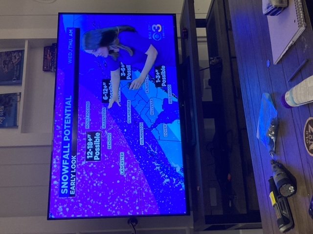
Channel 3 1st call!
-
18z gfs clobbers the metro!

-
1
-
-
2 minutes ago, Northof78 said:
GFS really squashes northern precip shield, really nice hit for the metro...
Yea..I would be slightly nervous north of I 84.
0z will be telling
-
2 minutes ago, wkd said:
Rgem moved northwesrt some.

Yea..off hour run..toss it. That’s more than some too!
-
 1
1
-
-
Final rain total
0.64
1.4 w Upper Chichester
-
21 minutes ago, MPotter_WX said:
Dumping snow here in the LV Wednesday evening with this depiction from the latest 18Z NAM 3 km. But that dreaded dry slot is quite close...

Yea..this dry slot seems to land somewhere in the region. 36 hours to change!
-
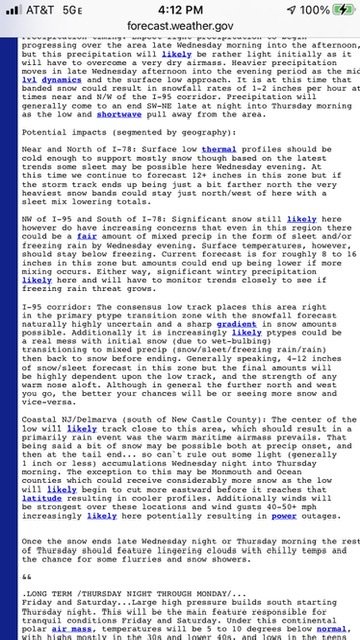
Afternoon afd from mt holly!
nice write up
-
3 minutes ago, ChescoWx said:
Snowing almost moderately temp down to 34.4 on VP and 32.9 on Tempest...ground whitening quickly now
That’s a significant temp difference between the instruments.
-
Just now, BlueDXer75 said:
I’d lock that up in a heartbeat.
Very consistent..next batter up is Canada!
-
12z rgem
-
1
-
-
2 minutes ago, Franklin0529 said:
Remember when I told u I thought it be tucked an mostly rain for the 95 an east crew an u called me a troll?
Let’s not start patting yourself on the back yet....
-
2
-
-
1 minute ago, MPotter_WX said:
On Twitter I saw a sensitivity analysis showing the implications of latent heat release within the downstream ridge. Has a lot to do with how the NAM is so amped (overdoing convection) with the GFS is so flat (under-doing convection). Guess we’ll see who can handle the convection better.
MJVentrice Twitter post is a few nails in the coffin for I 95 crowd!
-
6 minutes ago, Ralph Wiggum said:
6z Euro followed the NAM...mixing into the LV. So like the op said, rgem is likely out to lunch. Going to be intense banding somewhere N and W tho.
Saw that...toss it!
off hour model run.
-
 1
1
-
3
-
-
Just now, Ralph Wiggum said:
Rgem is probably closer wrt the banding features than most globals. Just a matter of pinpointing where.
Nam is awfully until 24 hours out. Once in a while it scores a touch down at this range.
-
11 minutes ago, Ralph Wiggum said:
On one hand the 6z NAM comes in and wants to bullseye Western PA.....then the RGEM comes out moments later and I damn near pass out seeing 2-3' across SE PA. Epic model war. One of these mesos is about to fail miserably. Truth probably lies in between?
6 nam was ugly
rgem is awesome
-
32 minutes ago, RedSky said:
14" for Philly with that track

Horrible run!
-
1
-
-
18z euro buries phl metro!
-
1
-
-
4 minutes ago, Birds~69 said:
Not too far N/W Philly has been 12"+ throughout for the most part of these runs. The gift that keeps on giving....
rgem drops 14 center city
-
1
-
-
4 minutes ago, RedSky said:
GFS cold and good, NW trend abated
Yea it’s been consistent.
just printed out 12-20 philly metro
-
1
-
1
-
-
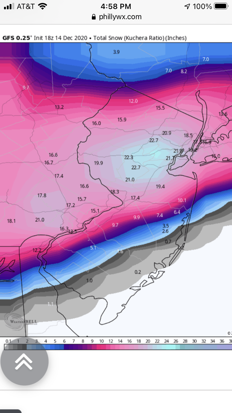
Mt Holly afternoon afd going with a switch to rain and sleet to the i 95 corridor! Noted the nam model which is a train wreck.
mostly all snow event further out in the burbs up through the poconos!
-
Just now, Newman said:
There's gonna be some dry wedges/dry slots mixed here, especially with that CCB cranking to our west in Central PA
Hopefully the storm tracks further south and east...would be a bear to watch it and we get light stuff or clouds for a time..can’t complain to much..

December 16-17, 2020 Winter Storm
in Philadelphia Region
Posted
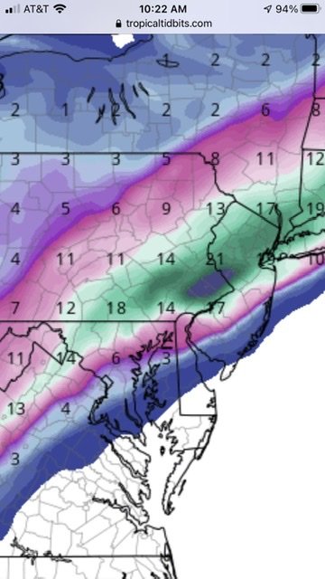
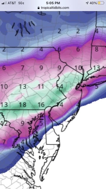
Pulled from New England 18z euro
safe to say phl get hit hard..liking 10 on my street. Heavy precip beats marginal temps Imop