

Ginx snewx
-
Posts
102,254 -
Joined
-
Last visited
Content Type
Profiles
Blogs
Forums
American Weather
Media Demo
Store
Gallery
Posts posted by Ginx snewx
-
-
It's funny usually we hear at this time frame all about the NAM trending North. It goes south and all of a sudden it's all about the GFS. Weenie world
-
3 minutes ago, CoastalWx said:
Track wise 12z nam is nice, but it needs to get much more meaty with the CCB.
Not even to bomb level yet, picture that run out 24 hrs with a 975 at the BM. Getting more interesting by the day.
-
 2
2
-
-
18 minutes ago, HoarfrostHubb said:
Sloppy white rain and some snow here. Sell those clowns.
You will be surprised. Does anyone inland not see the massive height falls and stalled CCB? Sell the GFS .I think crazy uncle Euro and GEM have the best grasp. Pretty much every ensemble member crushes you. Enjoy power loss.
-
3
-
-
20 minutes ago, Damage In Tolland said:
We’ll get another 2-6” of rain in CT out of this . Deep easterly inflow just hammers the moisture in and wrings out. 35 and 3 days of rain and strong wind gusts
We will see snow last 2 days though .
-
4 minutes ago, kdxken said:
So Friday is not looking good for golf in the Worcester hills?

Can I say I get guilty pleasure seeing Golf Cancel.
-
 1
1
-
-
4 hours ago, 40/70 Benchmark said:
We have this thing doing a blizzard loop over se MA on Thursday PM now....get that over the islands, then we can talk HECS over SNE.
But as is...I see why the discrepancy over saying the Uk is inland....it must be doing what the EURO is....technically it is inland, but not because it's a hugger....it's doing a blizzard loop and getting captured.
The height crash is real and it's spectacular.
-
Just lock it up NOP for big totals.
-
Hoist um up Monday PM.
-
2
-
 1
1
-
-
12 minutes ago, Torch Tiger said:
I remember it very well. 13 yrs old. Wiffle ball in the snow. 1st of 2 April snows
-
2
-
-
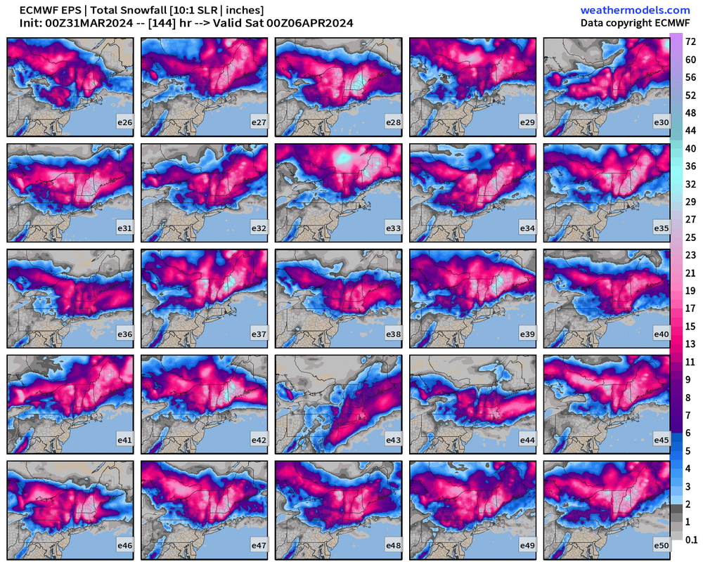
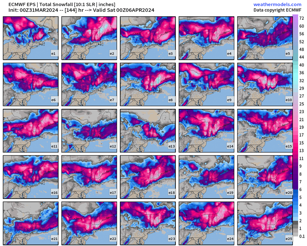
2 hours ago, ORH_wxman said:
Go back to the pre-clown map era when you have marginal temp profile….esp under 800-1000 feet
1. Look for 6 hourly QPF greater than 0.50”…preferably 0.75”+. The heavier the better, but 0.25 or 0.37 over 6 hours isn’t gonna cut it. That’s mostly white rain.
2. Look at 925 temps. Typically want -2ish or colder to avoid total slop though -1 will work if youre pounding with good snow growth aloft.
If you aren’t satisfying both of those criteria, then you’re looking at something significantly under 10:1 ratios.
Nocturnal timing for max precip can help a bit too, but it’s less significant than the two factors above.
ORH yellow thumpity thump
.thumb.png.c2f3871c048f95b56d8b250bdf7612fb.png)
.thumb.png.872a8be310a60217d62ebee57852b1ce.png)
.thumb.png.608ee1c266324424b1c311d0468dd2ce.png)
-
1
-
-
10 minutes ago, ChangeofSeasonsWX said:
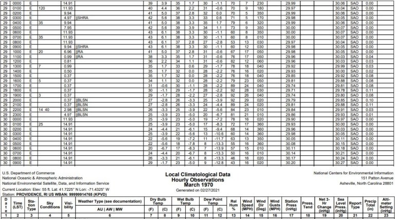
Everyone wants to keep bringing up 04/01/97 and 04/06/82, and yeah 1996-97 was a ratter until April 1st just like this season but this one just doesn't have the same dynamics as that one did, and April 1982 had a very cold airmass to work with. In terms of overall synoptics this one actually looks more similar to 03/29/70, but even that one had better dynamics to work with.
This is a bomb. Zero doubt
-
1
-
-
2 hours ago, powderfreak said:
Is that the same as positive depth change?
Depth at that time . There is no snow south of the Dendy area
-
1
-
-
2 hours ago, powderfreak said:
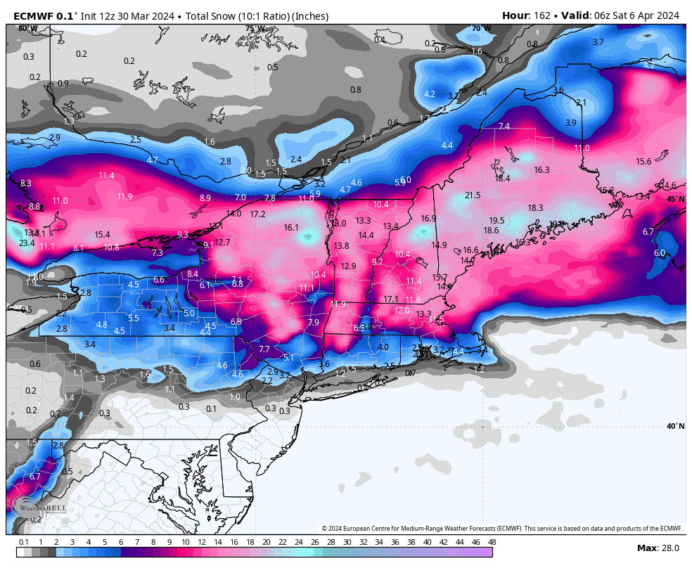
10:1 and then positive depth increase...
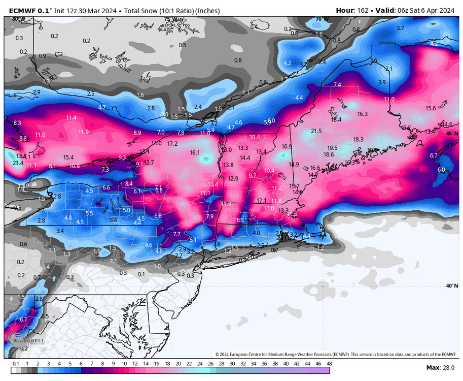
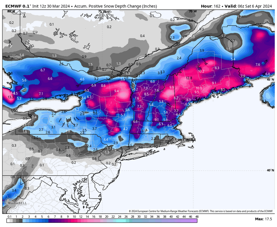
Could be a timing issue 132 depth change
.png.c3bac54b5c444a4c180064180ee0abf0.png)
-
-
As depicted the largest areal area April storm since 82 (shifted north)
-
24 minutes ago, 40/70 Benchmark said:
Looks like a First Call Sunday/Final Call Tuesday given Wednesday onset.
He's back....
-
23 minutes ago, powderfreak said:
It’s been very good this season to be honest. Numerous events the depth change has been much closer to reality with so many marginal temp events. The 10:1 maps stacking up white rain that the depth maps got right at 4:1.
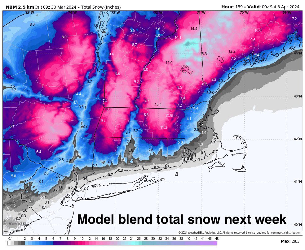
Don't buy it as depicted. Maybe typical April quick melt , but in storm??? . Bufkit will be better like the two footer you had
-
Just now, 40/70 Benchmark said:


That's nutz
-
1 minute ago, 40/70 Benchmark said:
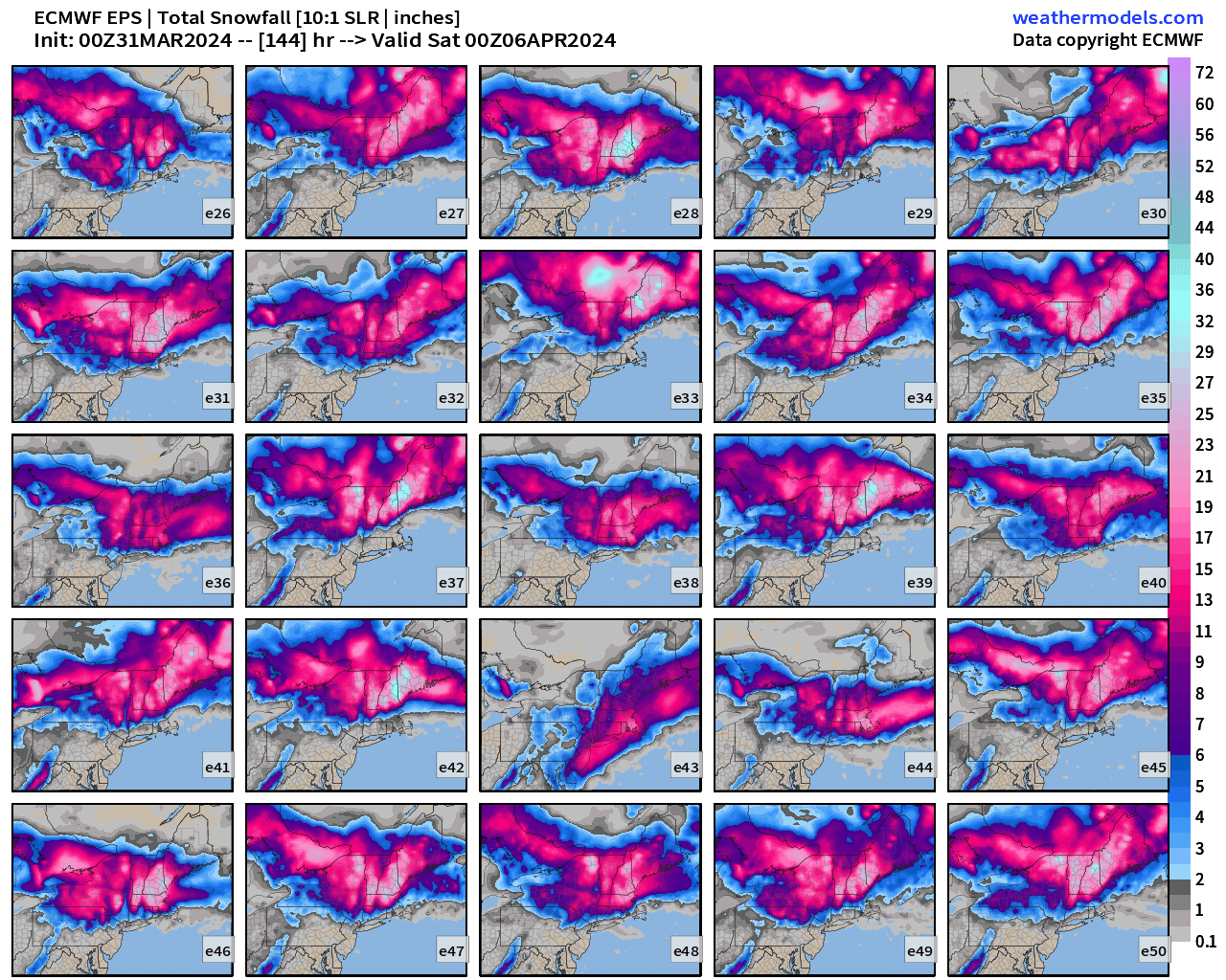
EPS tightened up overall and got more intense....better NOP, but a bit less SOP.
Yea....we type.
Crazy inflow. March 18 ish
-
1
-
-
1 minute ago, 40/70 Benchmark said:
12z EPS is even a little better than yesterday's bonkers mean.
Start typing you will thank me later. Its Classic Ray
-
2
-
-
2 minutes ago, 40/70 Benchmark said:
They probably have better retention that the E MA CP because they don't get the marine intrusions or the DSD days....kind of the inverse on how Kev doesn't get upslope like the ORH hills because he is more of a single hill than a chain. That area of VT doesn't get the general downslope on a prevailing westerly flow like the CP does.
24 minutes ago, powderfreak said:10:1 and then positive depth increase...
Depth change is always whacky
-
1
-
-
Last 960 ish April Storm?
-
3 minutes ago, RUNNAWAYICEBERG said:
Wish it was that easy. Need the 50:50 to work a miracle. Climo favors interor but anomalous storms do anomalous things.
Somebody needs to grenade the NAM. Congrats on a foot
-


.png.fa9888dd3571c3f8f94b54ff7299653e.png)
.png.64a5eedbecfe29363c94e1e2f3c7dfee.png)
.png.b390c3fc5fbbb0809ef38cf0d5a5551d.png)


Significant Miller B Nor'easter watch, Apr 3rd-4th
in New England
Posted
It's a proven fact. But let's see where this goes, people checking out early