

Ginx snewx
-
Posts
102,222 -
Joined
-
Last visited
Content Type
Profiles
Blogs
Forums
American Weather
Media Demo
Store
Gallery
Posts posted by Ginx snewx
-
-
Hoist um up Monday PM.
-
 2
2
-
 1
1
-
-
12 minutes ago, Torch Tiger said:
I remember it very well. 13 yrs old. Wiffle ball in the snow. 1st of 2 April snows
-
2
-
-
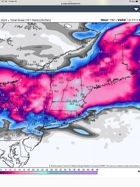
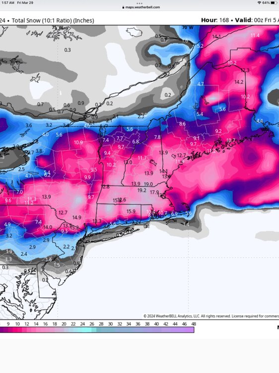
2 hours ago, ORH_wxman said:
Go back to the pre-clown map era when you have marginal temp profile….esp under 800-1000 feet
1. Look for 6 hourly QPF greater than 0.50”…preferably 0.75”+. The heavier the better, but 0.25 or 0.37 over 6 hours isn’t gonna cut it. That’s mostly white rain.
2. Look at 925 temps. Typically want -2ish or colder to avoid total slop though -1 will work if youre pounding with good snow growth aloft.
If you aren’t satisfying both of those criteria, then you’re looking at something significantly under 10:1 ratios.
Nocturnal timing for max precip can help a bit too, but it’s less significant than the two factors above.
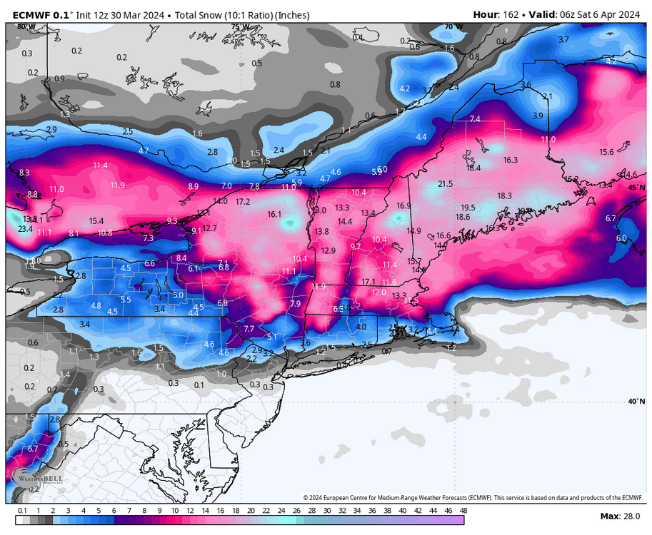
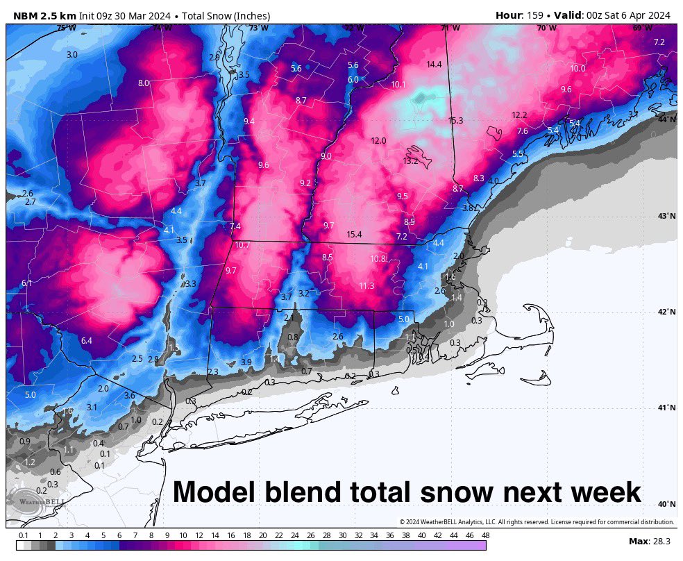
ORH yellow thumpity thump
.thumb.png.c2f3871c048f95b56d8b250bdf7612fb.png)
.thumb.png.872a8be310a60217d62ebee57852b1ce.png)
.thumb.png.608ee1c266324424b1c311d0468dd2ce.png)
-
1
-
-
10 minutes ago, ChangeofSeasonsWX said:
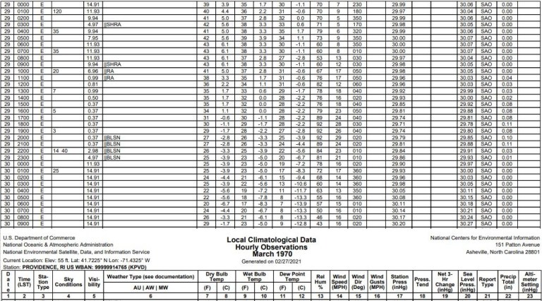
Everyone wants to keep bringing up 04/01/97 and 04/06/82, and yeah 1996-97 was a ratter until April 1st just like this season but this one just doesn't have the same dynamics as that one did, and April 1982 had a very cold airmass to work with. In terms of overall synoptics this one actually looks more similar to 03/29/70, but even that one had better dynamics to work with.
This is a bomb. Zero doubt
-
1
-
-
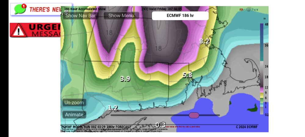
2 hours ago, powderfreak said:
Is that the same as positive depth change?
Depth at that time . There is no snow south of the Dendy area
-
1
-
-
2 hours ago, powderfreak said:
10:1 and then positive depth increase...
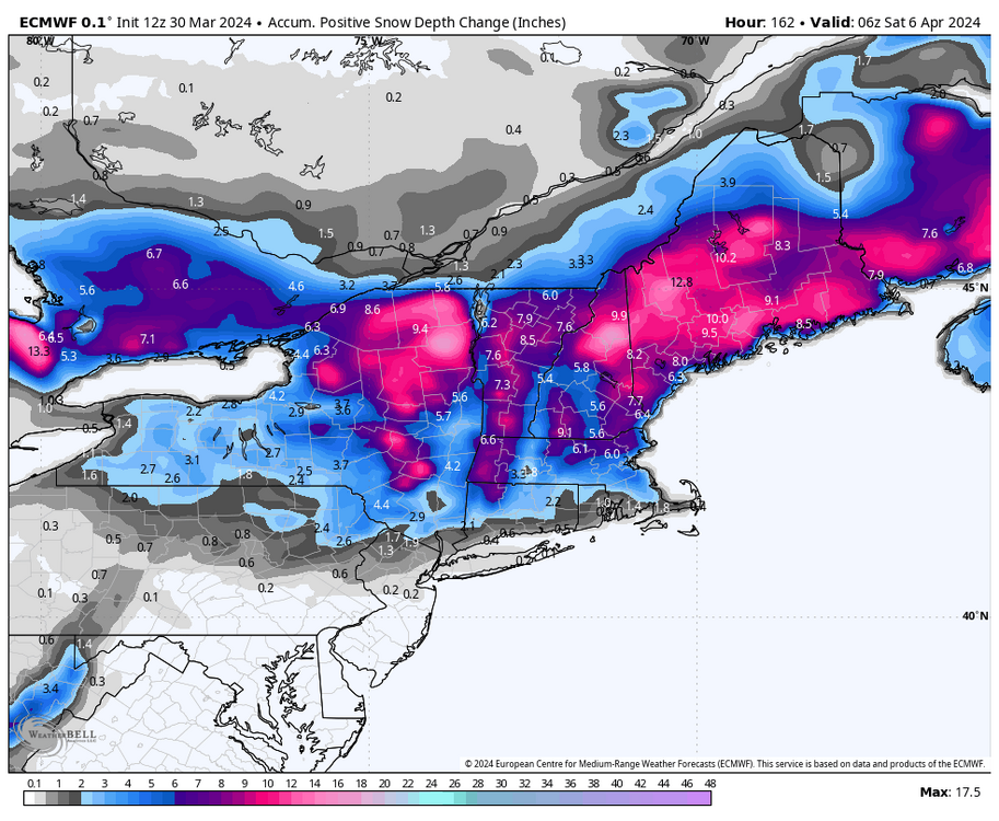
Could be a timing issue 132 depth change
.png.c3bac54b5c444a4c180064180ee0abf0.png)
-
-
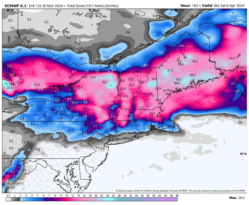
As depicted the largest areal area April storm since 82 (shifted north)
-
24 minutes ago, 40/70 Benchmark said:
Looks like a First Call Sunday/Final Call Tuesday given Wednesday onset.
He's back....
-
23 minutes ago, powderfreak said:
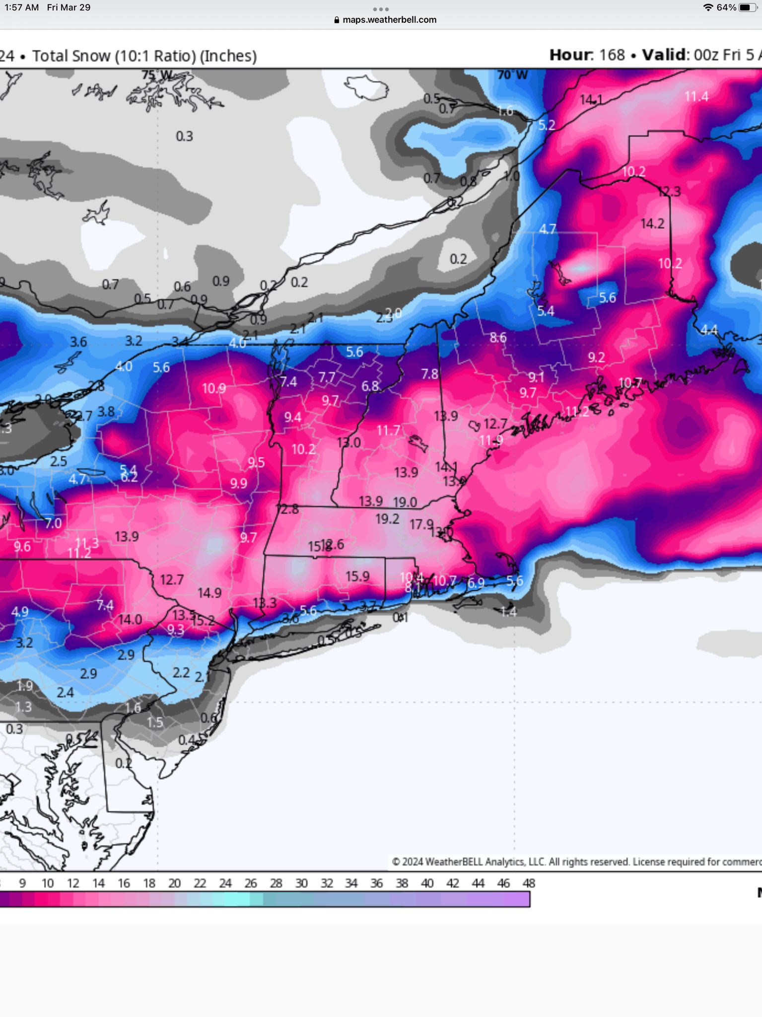
It’s been very good this season to be honest. Numerous events the depth change has been much closer to reality with so many marginal temp events. The 10:1 maps stacking up white rain that the depth maps got right at 4:1.
Don't buy it as depicted. Maybe typical April quick melt , but in storm??? . Bufkit will be better like the two footer you had
-
Just now, 40/70 Benchmark said:


That's nutz
-
1 minute ago, 40/70 Benchmark said:
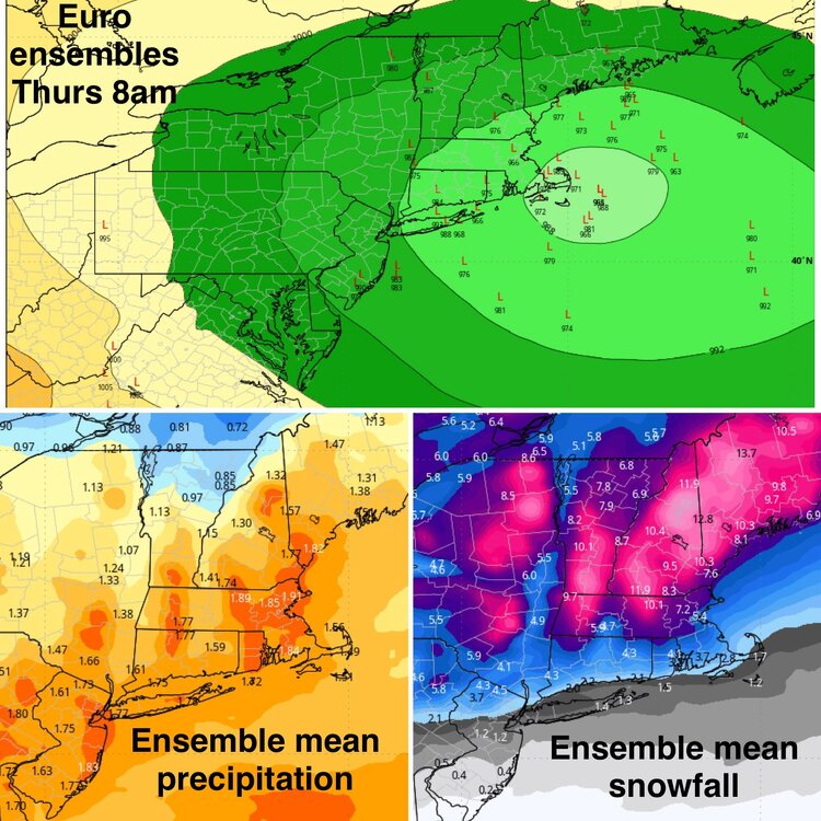
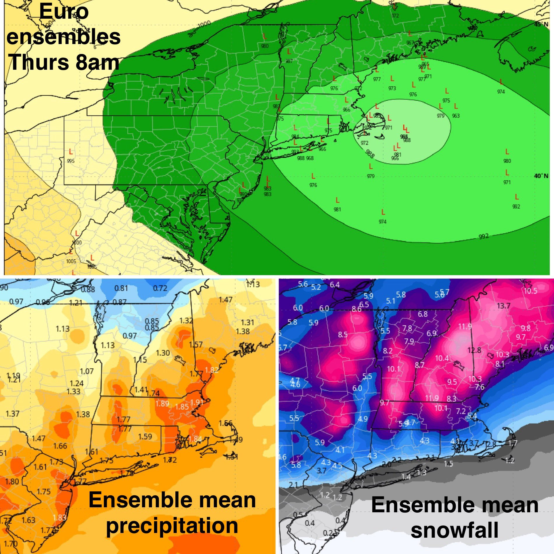
EPS tightened up overall and got more intense....better NOP, but a bit less SOP.
Yea....we type.
Crazy inflow. March 18 ish
-
1
-
-
1 minute ago, 40/70 Benchmark said:
12z EPS is even a little better than yesterday's bonkers mean.
Start typing you will thank me later. Its Classic Ray
-
2
-
-
2 minutes ago, 40/70 Benchmark said:
They probably have better retention that the E MA CP because they don't get the marine intrusions or the DSD days....kind of the inverse on how Kev doesn't get upslope like the ORH hills because he is more of a single hill than a chain. That area of VT doesn't get the general downslope on a prevailing westerly flow like the CP does.
24 minutes ago, powderfreak said:10:1 and then positive depth increase...
Depth change is always whacky
-
1
-
-
Last 960 ish April Storm?
-
3 minutes ago, RUNNAWAYICEBERG said:
Wish it was that easy. Need the 50:50 to work a miracle. Climo favors interor but anomalous storms do anomalous things.
Somebody needs to grenade the NAM. Congrats on a foot
-
-
42 minutes ago, dryslot said:
Want to be done with this winter.
28 minutes ago, weatherwiz said:I'm with you. I don't want to be tracking snow right now. I just want warmer/nicer weather. That tease we had earlier in the month propelled my brain right to warmer weather. If we didn't have that I may be more inclined to hope this could turn into a crushing...even for me
 19 minutes ago, HoarfrostHubb said:
Same. I'm moving into Sping mode
Cryin for their Mommas AWT
-
 2
2
-
 3
3
-
-
4 minutes ago, Damage In Tolland said:
I’d feel a lot better if I was Hunch and Ineedsnow. Probably screwed south of there . Persistence forecasting . Can’t go wrong anymore with it
Yea well it's also April so a safe call....for now
-
1
-
-
7 minutes ago, Damage In Tolland said:
Maybe this is the paster . Long way to go still . Expecting bad trends to start
Scooter blown into Harbor? Classic and
.png.d38c78d5a412a09d04b72b5cb6e5c8f0.png)
.png.56a355fce0aecb31cad2ec199a113913.png)
.png.ba832ef6d8223bb6c7fefc40406745d1.png)
.png.a8a9f37fdc870fdc99c4360d3f9f8d56.png)
.png.edc4ad5417cb58e05a317be219fd35a3.png)
-
1
-
-
Just now, Damage In Tolland said:
Maybe this is the paster . Long way to go still . Expecting bad trends to start
Looks great ORH North. From @eweather but has a Dec 92 feel
-
2
-
-
Cat paws here. Snow just above
-
2
-
-
3 minutes ago, dendrite said:
Either way at least we have another 1-2”+ of liquid coming.
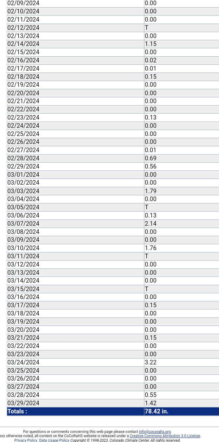
Ct state annual record is 78.63 . April 1 23 to today at my station. Unreal

-
1
-
-
19 minutes ago, CoastalWx said:
Gfs really first to show. Still glue.
32 minutes ago, dendrite said:A lot of cross model support for it now. Ugh.
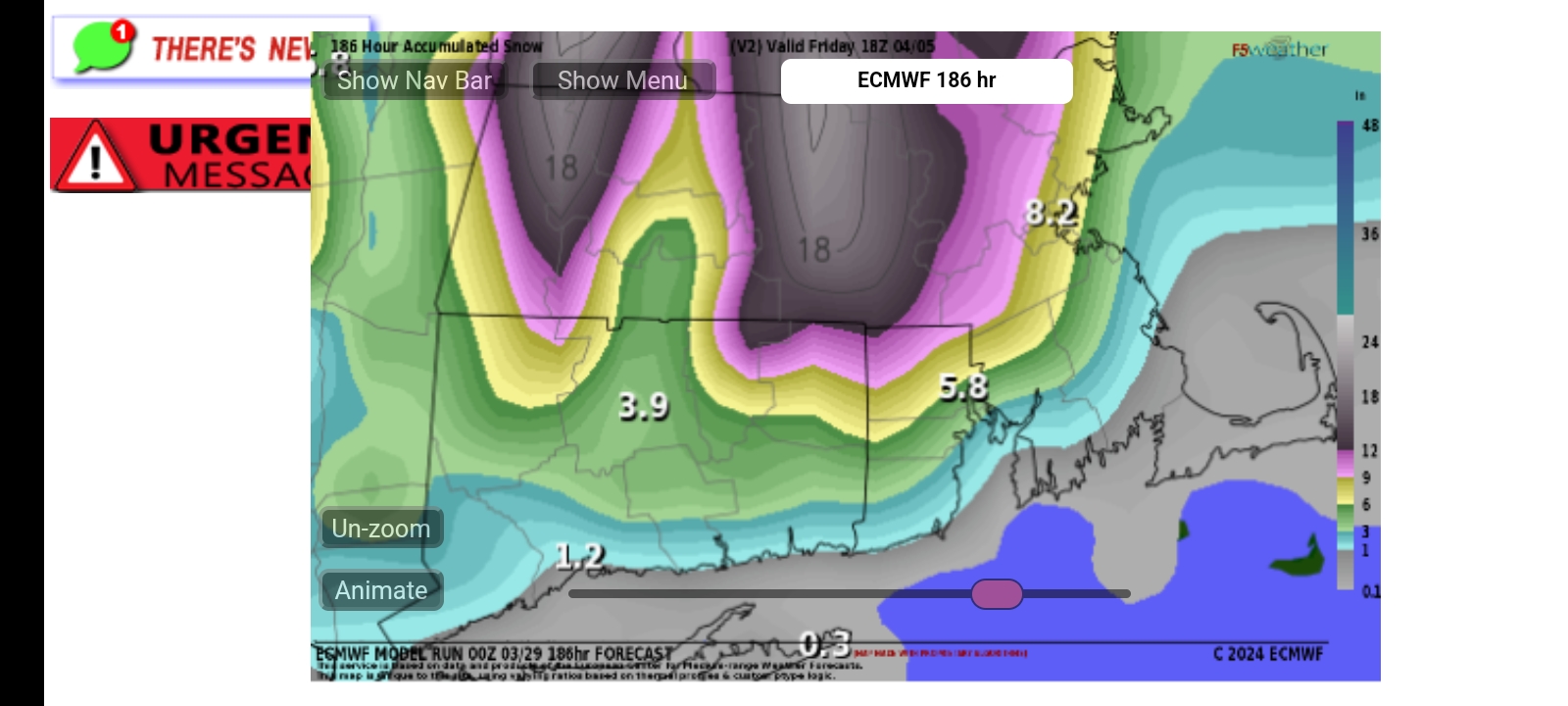
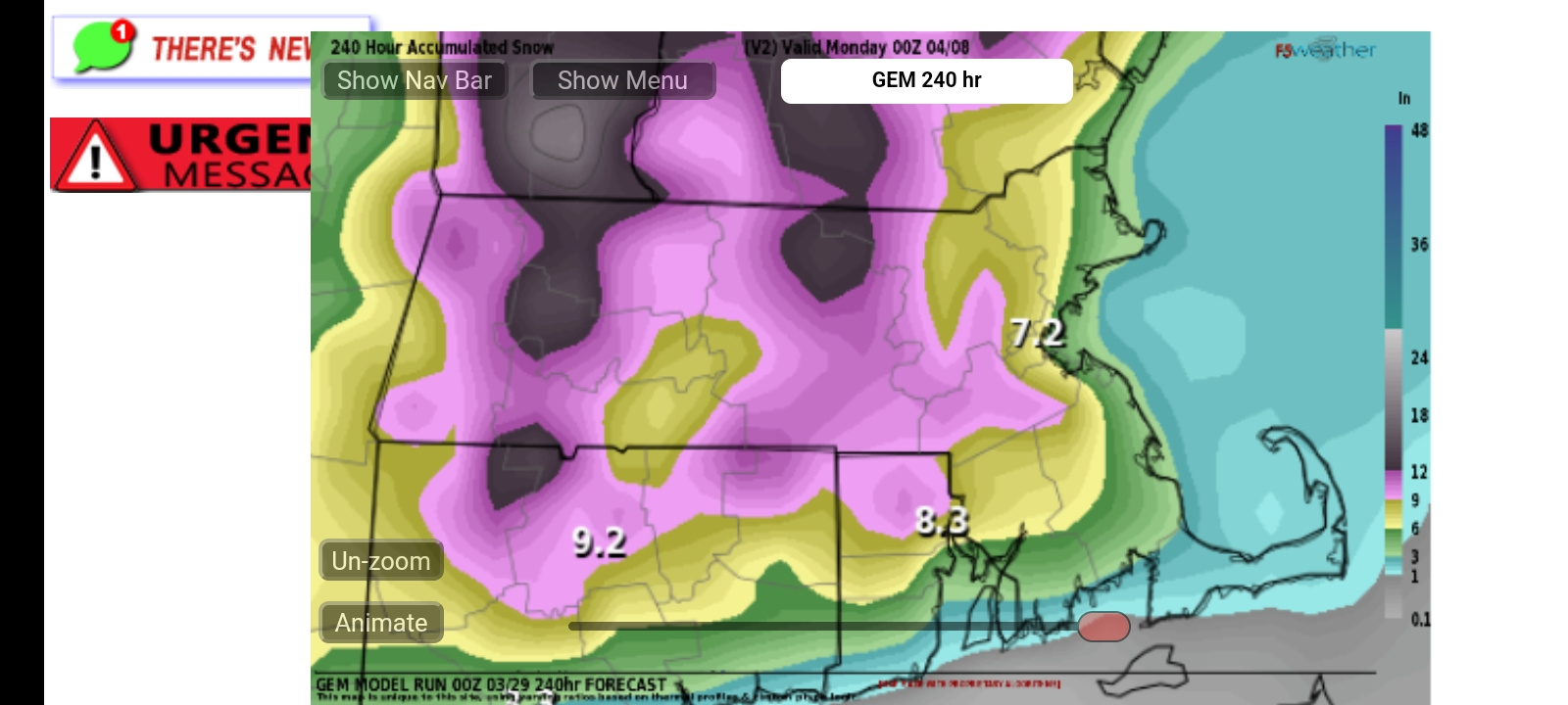
A clown for all and NARCAN for SNE Euro and GEM

-
1
-
.png.fa9888dd3571c3f8f94b54ff7299653e.png)
.png.64a5eedbecfe29363c94e1e2f3c7dfee.png)
.png.b390c3fc5fbbb0809ef38cf0d5a5551d.png)


Significant Miller B Nor'easter watch, Apr 3rd-4th
in New England
Posted
Just lock it up NOP for big totals.