

Scraff
-
Posts
4,412 -
Joined
-
Last visited
Content Type
Profiles
Blogs
Forums
American Weather
Media Demo
Store
Gallery
Posts posted by Scraff
-
-
By the way Caps fans and fellow snow / beer geeks......I had quite a bit to do with this one.
")
Only can get it starting Thursday at Downtown Crown and Georgetown Beer and Wine.

-
 2
2
-
-
10 minutes ago, nj2va said:
Welcome back Oshie! Signature PP goal by him.
They are looking stellar right now. Keep the foot to the floor...
-
1
-
-
Hmmmm. Anyone biting on this? Ohhhhh Canada....our home and native land...


-
1
-
-
6 minutes ago, GATECH said:
LOL! Not that far north! Steady light to almost moderate snow now here!
One can dream damn it.
")
-
1
-
-
Just now, WEATHER53 said:
Weeping negative Nellie
I’m just CAPE bitter.
-
5 minutes ago, GATECH said:
How far north does that deathband make it? Looks to be screaming north.
As far north to set up the MoCo / HoCo death band?
-
1
-
-
7 minutes ago, WEATHER53 said:
Certainly has worked it way very close with some time remaining.
Baro finally relaxed
Cutsey white flags, towel throws, I’m out, Game Over May have been premature
That awesome baroclinic leaf perhaps?
-
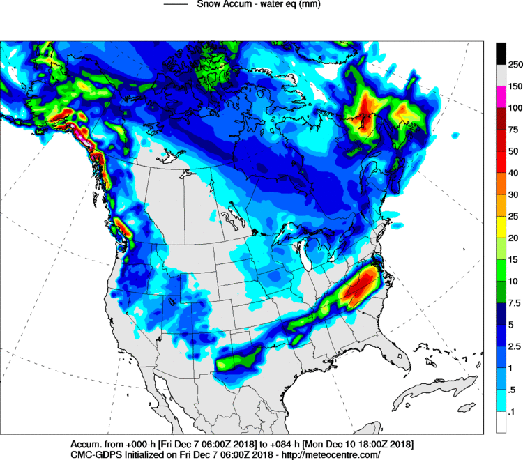
Looking into January, I believe it’s only going to get better. I know we all know this already, but still wanted to share.

-
18 minutes ago, cyclogenesis said:
December 8, 2018
this Saturday night
930 PM EST
*** Preface: This writing focuses ONLY on RICHMOND, VIRGINIA ***
Gang -- I researched after several iterations of data that poured in today on tomorrow's Dec. 9, Sunday's snowy event scheduled for Richmond, VA. Bottom line, for Richmond, is I'm expecting 5" to 8" of snowfall, with HIGHER amounts tapered SOUTH of Richmond and WEST of Richmond. Lower amounts fanning further North & East. I thinking Petersburg, for comparison may wind up with 6" to 10" there.
I think the event will start as SNOW, between 6 AM to 8 AM Sunday morning, for the Richmond area.
Then, around 4 PM Sunday, it's appearing there's going to be a mixture of rain & snow from 4 PM onward Sunday. As this transition occurs after 4 PM, it's also conceivable a mixture of ice pellets, (sleet), and perhaps freezing rain may become apparent, as you'll have to keep an eye on the air temperature. Remember, freezing rain can only occur when temperatures at the surface get to 32° & below, but the air temperature need not be freezing for snow or ice pellets to occur.
Each successive iteration I've been watching since 00Z last evening to 6Z this morning, to 12Z this Saturday morning keeps on INCREASING the amounts UPWARD for Richmond. However, there's a TIGHT gradient between amounts & as liquid as little as 2-3 counties EAST of Richmond, so busting on amounts will be higher in East Richmond, rather than West Richmond, where it's appearing a better solid lock on wintery weather there & in Chesterfield county will be more prominent.
In fact, Chesterfield county was looking like a PEAK local snowfall amount projected by this morning's 12Z, Sat., WRF indicating 1 foot, (12"), over thataways.
I generally ignore the NAM model as I find it's way overplayed on wintery weather events, so I'll only post what I believe to be more representative & capable of happening, down below.
Another trick here is that once 4 PM onward comes around, not all the QPF will fall as solid form. Once the rain hits, that'll reduce & compress the snowfall depths, beyond 4 PM. So, I'm thinking the snowfall depth is likely to be greatest, in the late afternoon, just before changing over to the rain snow mix, around 4 PM.
I. Amounts for Richmond
It WILL be HUGE variances spread out across the metro Richmond area. If you're living in Midlothian -- you'll get the HIGHEST amounts. If you're living in Mechanicsville, to East Richmond, that's where the lowest amounts will be. It's not going to be the same everywhere so don't expect it.
Here are the projection numbers of snowfall based near Richmond, VA for Sunday, Dec. 9th:
00Z, Sat ECMWF -->> 5.5" for Richmond
12Z, Sat ECMWF -->> 8" for Richmond
6Z, Sat GFS -->> 1.7" for Richmond
12Z, Sat GFS -->> 3.4" for Richmond (MOS: Trace to 2")
18Z, Sat GFS -->> 4.0" for Richmond
12Z, Sat, H-rap -->> 5.6" for Richmond to 7 PM Rain-snow mix 1 PM to 5 PM, East Richmond
18Z, Sat, H-rap -->> 8.6" for Richmond
12Z, Sat, WRF -->> 9" Richmond; but 12" Chesterfield County, betwen 8 AM Sunday - 1 AM Monday; 8 AM to 4 PM snow; then rain-snow mix 4 PM, Sunday to 1 AM, Monday.
12Z, UKM -->> Between 7 AM to 7 PM, 0.68" of QPF, liquid-equivalent.
Referring to UKM's QPF above, This means if it ALL fell as snow in those 12 hours, on a 10:1 ratio given the surface temperatures expected then this would translate to 6.8" of snowfall ~~ approx. 7" of snow.
** There WILL be compaction AND MELTING, too, once rain mixes-in **
II. Timing.
Timing looks to start about 7 AM Sunday, Dec. 9th, continue all-day long Sunday, in to Sunday night, concluding 1 AM Monday morning. All snow & wintery mixture ends by sunrise, Monday morning.
III. Measuring Snow.
If you'll be measuring snow, do so ONLY over exposed, FLAT grassy areas away from trees, away from buildings, and away from other structures, and make several measurements nearby in UN-drifted areas, and average up the number of readings, and divide by the number of measurements taken. Snowfall depth measurements are NOT taken from the highest heap of snow you see. It doesn't work like that.
IV. The Surface Low Details
At 7 AM Sunday morning, Dec. 9 --
The surface low will be situated in extreme Southeast Georgia, (29.82"), headed Northeastward.
At 1 PM, Sunday afternoon, Dec. 9 --
The surface low is to be located about 50 - 75 miles Southeast of Myrtle Beach, South Carolina, (at 29.69", deepening), headed Northeastward
At 4 PM, Sunday afternoon, Dec. 9 --
Surface low to be located about 30 to 100 miles South of Beaufort, North Carolina. Nam & ECMWF is closer to the Eastern North Carolina coast. Gfs is farther out, away from the coast, as deep as 29.56", still deepening.
After 4 PM surface low slows its forward speed Sunday night, and takes a rightward bend to the East Northeast, about 100-200 miles off the coast of the outer banks of North Carolina by 10 PM Sunday night. By this time the damage has already been done.
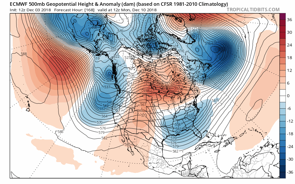
V. Upper features.
A broad upper-trough, whose trough axis runs meridionally across the state of Alabama will be in this position at 7 AM Sunday morning. The vorticity lobe axis will stretch from Western North Carolina to New Orleans, LA at that time, 7 AM Sunday. This trough will de-amplify with time, flattening & lifting out, exiting the Carolinas' coastlines by 4 PM Sunday.
An upstream kicker will be gliding across the Gulf south states of South Louisiana & Mississippi by 7 PM Sunday, which then exits the Carolinas' coasts by 7 AM Monday.
Richmond, VA will be under a stout right-entrance region of an exiting 250 mb 150+ kt jet max aloft, which is one of the enhanced regions for lift from Sunday morning to Sunday afternoon. A broad region of moderate upper divergence values will be centered over Virginia & North Carolina from Sunday morning thru early Sunday afternoon, before pulling off the coast.
VI. Thicknesses
GFS forecast thicknesses from 7 AM Sunday to 7 AM Monday start at 539 dm at 7 AM and gently rise to 541 dm by 7 PM. (What's this thickness all about & why care about it?) Those who watch winter storms are aware of the 1000 mb to 500 mb thickness values, and knowing where the 540 dm thickness line is at. Thicknesses at 540 dm & lower often correlate with snow & those values above 540 dm result in a mixture of snow-rain-freezing/frozen precipitation. A better capture of analyzing a site's specific location is inspection of the Skew-T sounding diagrams, to inspect for levels that rise above freezing to determine an often culprit for pesky ice pellets mixing in. So thicknesses are for generalization, but Skew-T's are more absolute.
The 1000-850 mb thicknesses, the line to watch here is the 1300 meter, and going below that for snow. This is analyzing only the lower levels. Here in Richmond, VA for tomorrow on Sunday, it's forecast to be 1283 m at 7 AM rising to 1303 by 7 PM.
So notice these 2 thicknesses and how they RISE by evening. This helps explain why there looks to be a transition from snow early in the day to a rain-snow mixture by evening hours.
Sure enough, an inspection of the text product output from the Gfs sounding indicates a +1.0° C above-freezing warmer layer rooted between 900 - 925 mb. This is between 2600 ft and 3350 ft. My notes on using the Tau technique is in storage. Bummer. I'll dig it out next snow event. No time for it tonight. Anyways, you can do some tinkering around yourself with the Tau technique. Looks to be ice pellets for such a shallow, narrowly-above freezing layer. But during the night, that warm layer aloft grows in depth & peaks at 2.8°C at 925 mb by 1 AM Monday. That's okay, because that's so late, and I don't see such a warm layer intervening during the daytime so snow should continue on as scheduled during daylight hours. Although, the surface temperatures will be hovering in the lower 30's, flirting above & below the freezing mark.
As a last exciting feature to close on the Nam's 18Z output generated 14.6" of snowfall and newest 00Z, Sun, 12/9 data rolling in a short while ago shows 14.1". As I said at the start of this writing, I ignore & disregard this Nam model; but it's there for your entertainment purposes, anyways! It's quite an extremist.
-- cyclogenesis
Can you repeat that?
-
1
-
 2
2
-
-
2 minutes ago, osfan24 said:
Not all that worried, though hate wasting opportunities. More just in awe of how a storm, especially this early in the year, loaded with moisture doesn't want to climb at all.
Yes. I get it. I’m definitely not happy either, but if you look ahead (especially the LR thread), the look doesn’t get much better for weeks and weeks on end. We’ll probably be sick of snow by end of January. LOLz.
Eta: Who I am kidding. Never can be sick of it.
-
7 minutes ago, osfan24 said:
Amazing watching that huge slug of moisture look like it's already hitting a brick wall across the south.
We will get ours. I’m not worried. Well unless I’m saying this in mid March.
")
-
1
-
-
I’m hearing through good sources that roads are likely going to cave it you’re planning a Friendsgiving in places such as Carbondale or Dover. But ONLY in those areas....straight face emoji...
-
19 minutes ago, yoda said:

Holy shnikes! I better make a toilet paper run ASAP.
-
13 minutes ago, NorthArlington101 said:

Hits the wall.All we are is just another brick in the wall...
-
1
-
1
-
-
6 minutes ago, yoda said:
Is it just me, or does the precip field at 33 on 00z NAM look a little more north and northeast compared to 39 at 18z?
Not that it will matter much up here... but still...
Pretend I just imbedded the “It’s Happening” gif.
-
12 minutes ago, attml said:
A little trend north - It is not done yet!
Maybe the New England wall won’t be as strong as anticipated. Get this to come north a few more ticks today and we good.
-
1
-
-
7 minutes ago, showmethesnow said:
Wouldn't write off the period just before Christmas. Been liking that period somewhat for the last few days. Get temps to cooperate...
HR 348 on the 6z GFS has what we’re looking for.
-
1
-
-
4 minutes ago, BTRWx's Thanks Giving said:
Interesting to see the trend how the ridge over central Canada strengthens. At this rate, we'll have a better chance of the New England low dropping down to phase than the weak wave out of the central U.S.
A few days ago we were all giddy that Boston wasn’t going to see a flake while we got buried. Talk about karma. It’s the New England low screwing us now!

-
1 minute ago, nj2va said:
At least the caps won
A real nice win. Needed that bad!
-
13 minutes ago, mappy said:
Jma discussion in the main thread?lordy help me
.At least it’s not the CRAS. lol
-
2
-
-
FV3 soooo close. Maybe JI can get some flurries.

-
3 minutes ago, DCTeacherman said:
Yeah it actually bumped about 50ish miles north of its previous run.
If we can get a 50 mile tick north each model run we’re in good shape....for Boston getting smoked.
-
Since 12z and so called storm mode...dis all I gots...

-
21 minutes ago, nj2va said:
Putting this here instead of the storm thread but I'd always take my chances with this look at the end of the 18z run of the NAM (blah blah yes its the NAM blah blah).


December Banter 2018
in Mid Atlantic
Posted
I work Duclaw sales in MoCo. I know the guys at DTC very well. We are both huge Caps fans, so we started talking about doing a collob. So I helped to facilitate the whole thing. Meetings at the brewery, discussions of beer type, labels, etc. The coolest part was I got to do the promo photo shoot. Here’s my favorite in my Ovi jersey.")