

Roger Smith
-
Posts
4,969 -
Joined
-
Last visited
Content Type
Profiles
Blogs
Forums
American Weather
Media Demo
Store
Gallery
Posts posted by Roger Smith
-
-
You people throw some mighty fine snow parties. I had two weeks like you're having now, back around end of December and into New Years. That snow is still in my back yard today despite the past five days being sunny and around 40-45 F.
-
Seems like a movie in the making ... SNOW WARS
Long long ago in a snowstorm far away
different measurement techniques came into conflict
"Luke, where is your snowboard?"
-
 1
1
-
-
12 minutes ago, CoastalWx said:
How did CrankyWx do?
He tried to jump but missed the window wide right.
-
 3
3
-
-
With this appearance, storm should have been Feb 14th perhaps ..
-
1
-
 1
1
-
-
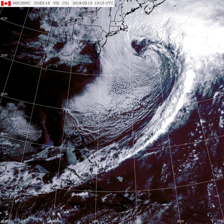
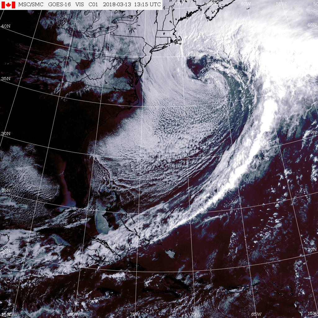
Strong pressure falls at 44008 (54 se ACK) to 975.7 mb at 1250z ... estimate center 965 mb at 39.5 N 68.8 W, appears to be phasing with upper low.
This will soon overcome the slight warmth left in boundary layer near sea level and become a raging blizzard (where it is not already) in e MA and some parts of RI, e CT.
Air temp only 34 F out in Mass Bay over 39 F water, likely to stabilize at about 31/31 at KBOS, S to S+ depending on banding location.
Enjoy.
-
-
Might be pretty close to that map, James, would suggest trending amounts west in VT though, BTV likely to get 8-10" at least.
-
I don't think it's slow, it's pivoting with an elongated center now, leading portion is around 38N 71W and trailing back at 36.5N 73W. It looks like it's trying to hook up with the inland ULL while the one chasing it is pushing it northeast, therefore some elements on radar and satellite imagery are moving more or less due north (across LI into s NE).
This will explode in next 3h, can already see the pressure falling faster now at buoy 44066 north of the center. Should be S+ over the Cape by daybreak.
http://www.ndbc.noaa.gov/station_page.php?station=44066
-
03z position is approx 36.5N 72.5W.
-
Someone was asking for a satellite animation ...
https://weather.gc.ca/satellite/satellite_anim_e.html?sat=goes&area=ecan&type=1070
You can adjust start time to get as long a loop as you want. Also this link should update to newer end times.
Spot the elongated center from east of Hatteras northeast to about 36N 73W (est 990 mb).
The upper lows are visible here, one east of SC and one near central Lake Huron.
===============================================================================
I am expecting this cyclone to continue a slow northeast motion overnight with likely twin center formation continuing to around 41N 67W (leading) and 39.5N 69.5W (trailing). There may be a period of stalling or slow north to NNW motion tomorrow mid-day to evening then resuming a northeast drift.
If any model error occurs it is likely to be a deeper 500 mb low over the Gulf of Maine or a faster phase of the two upper lows near NYC. Either of those would add 4-8" additional snow to current forecasts.
My guesses are ... max 24-32" south of BOS (centered on Taunton-Plymouth) and 20 to 30" BOS to PWM to BGR into w NB, 15 to 24" Cape (east of max) and also west of coastal strip as far as central MA into e CT, gradual reduction further west to 2-4" NYC and ALB. About 10-15" in most of VT and 15-25" in most of NH/ME not in the higher coastal strip amounts.
-
1
-
-
The models have an awkward look to the interaction between GL ULL and coastal ULL around 24-30h, the elongated unified version may turn out more as a rapid domination of the coastal meaning that its heights would drop faster than shown. This could cause the deep surface low to stall or even loop (counter-clockwise) in the Gulf of Maine.
If something like that happens, 20 to 35 inch amounts are very likely in the coastal strip. If it goes the way we are being shown so far, still could be 16 to 28 inch amounts.
-
Snow ends when? (map above) ... looks like it doesn't match line before it
-
Wow, that's some bomb in exactly the right place ...
20-25" potential for coastal to 100 miles inland from this.
-
1
-
-
SBY snow reports are not always very timely (from their CF6) so I'm wondering what you think was the actual snowfall at SBY on Wednesday 17th? (data needed for snowfall contest). Thanks.
-
1195
First max risk March 31st
-
Ranking seasons 1851 to 2017
167 North Atlantic tropical storm (or hurricane) seasons are ranked below by number of storms, then by hurricanes, and finally by major hurricanes. (original post) The assumption is made that 2017 will finish 17/10/5 and this assumption will be edited at the end of the season. 2017* may change ranks. It currently stands 9th and would stay there at 18/10/5 or 18/11/5.
(edit October 14 at 15z -- NHC upgraded Ophelia to cat-3 which means the assumption has now changed to a finish of 17/10/6 but it will remain 9th at 18/10/6 or 18/11/6.)
(update Nov 9th -- With Philippe and Rina in the books now, 2017 has made my guesstimate of 17/10/6. Any further increases will be noted but 2017 remains 9th if it adds one more storm even if that becomes a hurricane.)
(update Jan 2018 ... final count confirmed as 17 10 6 for 2017)
RANK _ YEAR ___ S __ H __ M _____ RANK __ YEAR ____ S __ H __ M _____ RANK __ YEAR ___ S _ M _ H
_ 1 ___ 2005 ___ 28 _ 15 __ 7 ______ 61 ___ 1898 ____ 11 __ 5 __ 1 _____ 119t___ 1972 _____7 _ 3 _ 0
_ 2 ___ 1933 ___ 20 _ 11 __ 6 ______ 62t___ 1974 ____ 11 __ 4 __ 2 _____ 119t___ 1994 _____7 _ 3 _ 0
_ 3 ___ 2010 ___ 19 _ 12 __ 5 ______ 62t___ 2015 ____ 11 __ 4 __ 2 _____ 123 ___ 1858 _____6 _ 6 _ 0
_ 4 ___ 1995 ___ 19 _ 11 __ 5 ______ 64t___ 1937 ____ 11 __ 4 __ 1 _____ 124 ___ 1915 _____6 _ 5 _ 3
_ 5 ___ 1887 ___ 19 _ 11 __ 2 ______ 64t___ 1942 ____ 11 __ 4 __ 1 _____ 125t___ 1875 _____6 _ 5 _ 1
_ 6 ___ 2012 ___ 19 _ 10 __ 2 ______ 66t___ 1869 ____ 10 __ 7 __ 1 _____ 125t___ 1977 _____6 _ 5 _ 1
_ 7 ___ 2011 ___ 19 __ 7 __ 4 ______ 66t___ 1891 ____ 10 __ 7 __ 1 _____ 127 ___ 1941 _____6 _ 4 _ 3
_ 8 ___ 1969 ___ 18 _ 12 __ 5 ______ 66t___ 1903 ____ 10 __ 7 __ 1 _____ 128t___ 1856 _____6 _ 4 _ 2
_ 9 ___ 2017*___ 17 _ 10 __ 6 ______ 69 ___ 1948 ____ 10 __ 6 __ 4 _____ 128t___ 1882 ____ 6 _ 4 _ 2
_10 ___ 1936 ___ 17 __ 7 __ 1 ______ 70 ___ 1976 ____ 10 __ 6 __ 2 _____ 130t___ 1918 _____6 _ 4 _ 1
_11 ___ 1950 ___ 16 _ 11 __ 6 ______ 71 ___ 1908 ____ 10 __ 6 __ 1 _____ 130t___ 1965 _____6 _ 4 _ 1
_12 ___ 2008 ___ 16 __ 8 __ 5 ______ 72t___ 1943 ____ 10 __ 5 __ 2 _____ 132t___ 1904 _____6 _ 4 _ 0
_13t___ 1954 ___ 16 __ 7 __ 3 ______ 72t___ 1947 ____ 10 __ 5 __ 2 _____ 132t___ 1913 _____6 _ 4 _ 0
_13t___ 2003 ___ 16 __ 7 __ 3 ______ 72t___ 1970 ____ 10 __ 5 __ 2 _____ 132t___ 1986 _____6 _ 4 _ 0
_15 ___ 1949 ___ 16 __ 7 __ 2 ______ 72t___ 2006 ____ 10 __ 5 __ 2 _____ 135t___ 1851 _____6 _ 3 _ 1
_16 ___ 1916 ___ 15 _ 10 __ 5 ______ 76 ___ 1899 ____ 10 __ 3 __ 2 _____ 135t___ 1939 _____6 _ 3 _ 1
_17 ___ 2004 ___ 15 __ 9 __ 6 ______ 77 ___ 1963 _____ 9 __ 7 __ 2 _____ 137t___ 1862 _____6 _ 3 _ 0
_18 ___ 2001 ___ 15 __ 9 __ 4 ______ 78 ___ 1975 _____ 9 __ 6 __ 3 _____ 137t___ 1897 _____6 _ 3 _ 0
_19 ___ 2000 ___ 15 __ 8 __ 3 ______ 79 ___ 1888 _____ 9 __ 6 __ 2 _____ 137t___ 1911 _____6 _ 3 _ 0
_20 ___ 1932 ___ 15 __ 6 __ 4 ______ 80 ___ 1867 _____ 9 __ 6 __ 1 _____ 140 ___ 1982 _____6 _ 2 _ 1
_21 ___ 2007 ___ 15 __ 6 __ 2 ______ 81t___ 1889 _____ 9 __ 6 __ 0 _____ 141 ___ 1895 _____6 _ 2 _ 0
_22 ___ 1998 ___ 14 _ 10 __ 3 ______ 81t___ 1940 _____ 9 __ 6 __ 0 _____ 142 ___ 1852 _____5 _ 5 _ 1
_23 ___ 1944 ___ 14 __ 8 __ 3 ______ 83 ___ 1979 _____ 9 __ 5 __ 2 _____ 143 ___ 1876 _____5 _ 4 _ 2
_24 ___ 1990 ___ 14 __ 8 __ 1 ______ 84t___ 1863 _____ 9 __ 5 __ 0 _____ 144 ___ 1855 _____5 _ 4 _ 1
_25 ___ 1953 ___ 14 __ 7 __ 3 ______ 84t___ 1892 _____ 9 __ 5 __ 0 _____ 145t___ 1872 _____5 _ 4 _ 0
_26 ___ 1959 ___ 14 __ 7 __ 2 ______ 86 ___ 1938 _____ 9 __ 4 __ 2 _____ 145t___ 1920 _____5 _ 4 _ 0
_27 ___ 2016 ___ 14 __ 6 __ 2 ______ 87 ___ 1923 _____ 9 __ 4 __ 1 _____ 147 ___ 1873 _____5 _ 3 _ 2
_28 ___ 2013 ___ 14 __ 2 __ 0 ______ 88 ___ 2009 _____ 9 __ 3 __ 2 _____ 148t___ 1854 _____5 _ 3 _ 1
_29 ___ 1955 ___ 13 _ 10 __ 5 ______ 89 ___ 1859 _____ 8 __ 7 __ 1 _____ 148t___ 1910 _____5 _ 3 _ 1
_30 ___ 1996 ___ 13 __ 9 __ 6 ______ 90t___ 1871 _____ 8 __ 6 __ 2 _____ 148t___ 1922 _____5 _ 3 _ 1
_31 ___ 1934 ___ 13 __ 7 __ 1 ______ 90t___ 1879 _____ 8 __ 6 __ 2 _____ 148t___ 1929 _____5 _ 3 _ 1
_32t___ 1901 ___ 13 __ 6 __ 1 ______ 90t___ 2014 _____ 8 __ 6 __ 2 _____ 148t___ 1962 _____5 _ 3 _ 1
_32t___ 1971 ___ 13 __ 6 __ 1 ______ 93t___ 1861 _____ 8 __ 6 __ 0 _____ 153t___ 1864 _____5 _ 3 _ 0
_34 ___ 1984 ___ 13 __ 5 __ 1 ______ 93t___ 1885 _____ 8 __ 6 __ 0 _____ 153t___ 1902 _____5 _ 3 _ 0
_35 ___ 1931 ___ 13 __ 3 __ 1 ______ 95 ___ 1935 _____ 8 __ 5 __ 3 _____ 155 ___ 1919 _____5 _ 2 _ 1
_36 ___ 1893 ___ 12 _ 10 __ 5 ______ 96 ___ 1967 _____ 8 __ 5 __ 1 _____ 156 ___ 1905 _____5 _ 1 _ 1
_37 ___ 1886 ___ 12 _ 10 __ 4 ______ 97t___ 1853 _____ 8 __ 4 __ 2 _____ 157 ___ 1907 _____5 _ 0 _ 0
_38 ___ 1878 ___ 12 _ 10 __ 2 ______ 97t___ 1960 _____ 8 __ 4 __ 2 _____ 158 ___ 1884 _____4 _ 4 _ 1
_39 ___ 1999 ___ 12 __ 8 __ 5 ______ 97t___ 1991 _____ 8 __ 4 __ 2 _____ 159 ___ 1883 _____4 _ 3 _ 2
_40 ___ 1951 ___ 12 __ 8 __ 3 ______100t___ 1927 _____ 8 __ 4 __ 1 _____ 160 ___ 1983 ____ 4 _ 3 _ 1
_41t___ 1958 ___ 12 __ 7 __ 3 ______100t___ 1973 _____ 8 __ 4 __ 1 _____ 161t___ 1857 _____4 _ 3 _ 0
_41t___ 1981 ___ 12 __ 7 __ 3 ______100t___ 1993 _____ 8 __ 4 __ 1 _____ 161t___ 1868 _____4 _ 3 _ 0
_43 ___ 1964 ___ 12 __ 6 __ 6 ______103 ___ 1968 _____ 8 __ 4 __ 0 _____ 163 ___ 1917 _____4 _ 2 _ 2
_44 ___ 1909 ___ 12 __ 6 __ 4 ______104 ___ 1957 _____ 8 __ 3 __ 2 _____ 164 ___ 1890 _____4 _ 2 _ 1
_45 ___ 1988 ___ 12 __ 5 __ 3 ______105t___ 1877 _____ 8 __ 3 __ 1 _____ 165 ___ 1925 _____4 _ 1 _ 0
_46 ___ 1978 ___ 12 __ 5 __ 2 ______105t___ 1997 _____ 8 __ 3 __ 1 _____ 166 ___ 1930 _____3 _ 2 _ 2
_47 ___ 2002 ___ 12 __ 4 __ 2 ______107 ___ 1896 _____ 7 __ 6 __ 2 _____ 167 ___ 1914 _____1 _ 0 _ 0
_48 ___ 1956 ___ 12 __ 4 __ 1 ______108t___ 1860 _____ 7 __ 6 __ 1 _______
_49 ___ 1870 ___ 11 _ 10 __ 2 ______108t___ 1866 _____ 7 __ 6 __ 1 _______
_50t___ 1880 ___ 11 __ 9 __ 2 ______110 ___ 1894 _____ 7 __ 5 __ 4 _______
_50t___ 1980 ___ 11 __ 9 __ 2 ______111 ___ 1921 _____ 7 __ 5 __ 2 _______
_52 ___ 1961 ___ 11 __ 8 __ 7 ______112t___ 1912 _____ 7 __ 4 __ 1 _______
_53 ___ 1926 ___ 11 __ 8 __ 6 ______112t___ 1928 _____ 7 __ 4 __ 1 _______
_54t___ 1966 ___ 11 __ 7 __ 3 ______112t___ 1992 _____ 7 __ 4 __ 1 _______
_54t___ 1985 ___ 11 __ 7 __ 3 ______115t___ 1874 _____ 7 __ 4 __ 0 _______
_56 ___ 1989 ___ 11 __ 7 __ 2 ______115t___ 1881 _____ 7 __ 4 __ 0 _______
_57 ___ 1906 ___ 11 __ 6 __ 3 ______117 ___ 1900 _____ 7 __ 3 __ 2 _______
_58t___ 1924 ___ 11 __ 5 __ 2 ______118 ___ 1987 _____ 7 __ 3 __ 1 _______
_58t___ 1945 ___ 11 __ 5 __ 2 ______119t___ 1865 _____ 7 __ 3 __ 0 _______
_58t___ 1952 ___ 11 __ 5 __ 2 ______119t___ 1946 _____ 7 __ 3 __ 0 _______
_____________________________________________________________________
RANKS by Hurricanes only
Rank __YEAR __________________________ H (M) ______ rank of majors
__ 1 __ 2005 _________________________ 15 _ 7 _______ 1 (2 tied)
__ 2t__ 1969, 2010 ____________________ 12 _ 5 _______ 9 (9 tied)
__ 4t__ 1933, 1950 ____________________ 11 _ 6 _______ 3 (7 tied)
__ 6 __ 1995 _________________________ 11 _ 5 _______10 (8 tied)
__ 7 __ 1887 _________________________ 11 _ 2 _______42 (46 tied)
__ 8 __ 2017 _________________________ 10 _ 6 _______ 3 (7 tied)
__ 9t __ 1893, 1916, 1955 ______________ 10 _ 5 _______10 (8 tied)
_ 12 __ 1886 _________________________ 10 _ 4 _______18 (7 tied)
_ 13 __ 1998 _________________________ 10 _ 3 _______25 (17 tied)
_ 14t _ 1870, 1878, 2012 _______________ 10 _ 2 _______42 (46 tied)
_ 17t__ 1996, 2004 ____________________ 9 _ 6 _______ 3 (7 tied)
_ 19 __ 2001 _________________________ 9 _ 4 _______18 (7 tied)
_ 20t__ 1880, 1980 ____________________ 9 _ 2 _______42 (46 tied)
_ 22 __ 1961 _________________________ 8 _ 7 _______ 1 (2 tied)
_ 23 __ 1926 _________________________ 8 _ 6 _______ 3 (7 tied)
_ 24t__ 1999, 2008 ____________________ 8 _ 5 _______10 (8 tied)
_ 26t__ 1944, 1951, 2000 _______________ 8 _ 3 _______25 (17 tied)
_ 29 __ 1990 _________________________ 8 _ 1 _______ 88 (49 tied)
_ 30 __ 2011 _________________________ 7 _ 4 _______ 18 (7 tied)
_ 31t__ 1953,54,58, 1966, 1981,85, 2003 __ 7 _ 3 _______ 25 (17 tied)
_ 38t__ 1949, 1959, 1963, 1989 __________7 _ 2 _______ 42 (46 tied)
_ 42t__ 1859,1869,1891,1903,1934,1936___7 _ 1 ________88 (49 tied)
_ 48 __ 1964 _________________________6 _ 6 ________ 3 (7 tied)
_ 49t__ 1909, 1932, 1948 ______________ 6 _ 4 _______ 18 (7 tied)
_ 52 __ 1906, 1975 ____________________6 _ 3 _______ 25 (17 tied)
_ 54t__ 1871,79,88,96, 1976, 2007,14,16 __6 _ 2 _______ 42 (46 tied)
_ 62t__ 1860,66,67 1901,08, 1971 _______ 6 _ 1 _______ 88 (49 tied)
_ 68t__ 1858, 1861, 1885, 1889, 1940 ____6 _ 0 ______ 137 (31 tied)
_ 73 __ 1894 ________________________ 5 _ 4 ______ 18 (7 tied)
_ 74t__ 1915, 1935, 1988 ______________ 5 _ 3 ______ 25 (17 tied)
_ 77t__1921,24,43,45,47,52,70,78,79,2006_5 _ 2 ______ 42 (46 tied)
_ 87t__1852,1875,1898, 1967,1977,1984 __5 _ 1 ______ 88 (49 tied)
_ 93t__ 1863, 1892 ___________________ 5 _ 0 ______ 137 (31 tied)
_ 95 __ 1941 ________________________ 4 _ 3 ______ 25 (17 tied)
_ 96t __1853,56,76,82,
_________ 1938,60,74,91, 2002, 2015 ___ 4 _ 2 ______ 42 (46 tied)
_106t __1855,84, 1912,18,23,27,28,
________1937,42,56,65,73,92,93 _______ 4 _ 1 _______ 88 (49 tied)
_120t __1872,74,81, 1904,13,20,68,86 ___ 4 _ 0 ______ 137 (31 tied)
_128t __1873,83,99, 1900, 1957, 2009 ___ 3 _ 2 _______ 42 (46 tied)
_134t __1851,54,77, 1910,22,29,
________ 1931,39,62,83,87,97 _________ 3 _ 1 ________ 88 (49 tied)
_146t __1857,62,64,65,68, 1897,
________ 1902, 1911, 1946, 1972, 1994__3 _ 0 ________137 (31 tied)
_157t __ 1917, 1930 _________________ 2 _ 2 ________ 42 (46 tied)
_159t __ 1890, 1919, 1982 ____________ 2 _ 1 ________ 88 (49 tied)
_162t __ 1895, 2013 _________________ 2 _ 0 ________ 137 (31 tied)
_164 ___ 1905 ______________________ 1 _ 1 ________ 88 (49 tied)
_165 ___ 1925 ______________________ 1 _ 0 ________ 137 (31 tied)
_166t __ 1907, 1914 _________________ 0 _ 0 ________ 137 (31 tied)
____________________________________________________
seasons with this many majors:
7 _ 2
6 _ 7
5 _ 8
4 _ 7
3 _17
2 _46
1 _49
0 _31
-
1
-
-
This is the first detailed report I have seen from Dominica.
https://pressroom.oecs.org/hurricane-maria-situation-report-1
(note there is an embedded NHC link which the report must have meant to freeze at Dominica's encounter but it shows the current advisory, ignore that part ... the pictures are about what I had envisaged and one can only imagine what may have occurred in isolated communities closer to the eyewall track).
-
I believe the fastest moving Atlantic tropical cyclone on record was the 1938 "Long Island Express." It went from 30 N 75 W at 00z Sept 21 to 35 N 73.5W at 12z, near 40 N at 18z and made landfall on Long Island (41 N) at 21z. By 00z it was in southern VT at 43N. So it gained 13 deg of latitude while shifting about 2 deg east in 24 hours, and was travelling over 60 mph at some points.
You have to wonder how well modern computer models would have handled it.
-
2
-
-
10 minutes ago, LVLion77 said:
I hope that irma and maria serve as a reminder that the basics still hold true for tropical cyclones- land damages tropical systems.
and vice-versa
-
10
-
-
Arecibo reports now updated to (edit) 1418z, peak gust 98 knots at 1354z (wind still NE to 1418z and still gusting to 96 knots).
Degraded eye must be very close now, next hour of reports will probably capture it if the sensors survive the surge.
Interesting to note that sustained winds increase from 72 knots at 10m to 78 knots at 20m. If that rate of increase was sustained to 100m (top of high rise buildings in San Juan) it would imply 126 knots at that level -- probably not quite that linear but over 100 knots likely.
-
The Arecibo reports have updated for 1254z to 1318z and show a slight veering from NNE to NE, peak gust so far was at 1312z, 87 knots. Eye might come very close to this location soon.
-
On subject of "weakening" at landfall, in these cases where a strong hurricane approaches a hilly or mountainous region, we have to understand that the forward half of the circulation is being squeezed up so there would be some tendency for the surface elements of the eyewall region to be lifted up near the coast, net effect being a pressure rise and wind decrease at sea level but no doubt the cat-5 winds continued on to make an elevated landfall.
When Patricia came inland there was evidence that pressures had risen 30-40 mbs in the six hours to landfall but winds at some elevation inland (northwest portion of eyewall) were still representative of lower eye central pressures, so really this discussion is somewhat moot, it depends on where you want to measure the winds -- but officially it is the conditions at the sea level landfall point. Those may not be known for a while but from the radar I suspect there may be patchy cat-5 damage evidence in the right front quarter of the eyewall. There will probably be widespread cat-5 type blowdown on ridges (and unfortunately the radar was located in such a spot).
-
Just for the historical record in this thread, CNN reporters in San Juan and on east coast just north of landfall have taken cover inside and their videos of outside conditions appear consistent with cat-3 or cat-4 conditions ... they can't stand up to report from even sheltered spots outside.
Meanwhile, eye approaching Arecibo on northwest coast, winds steadily increasing to NNE 62 knots gusting 85 knots at 0048z. Observing site on shoreline reports every 6 min, don't think we get to see next ten reports until 0148z transmission (but watching for them). No pressure report from this data buoy.
-
Rainfalls of 20-30 inches cannot be ruled out over higher ground in PR, based on observed rainfall rates over Guadeloupe last night. Similar intensity typhoons hitting south-central Taiwan have produced 8-12 inch per hour rates and 30-50 inch totals.
-
1
-
Predict/Guess the Number of Tornadoes and the First High Risk of 2018
in Central/Western States
Posted
It would appear that all but four of our predicted first high risks are now in the rear view mirror and out of the running with three left standing in May and one in Nov (well the latest of the passed dates is April 9 so that one remains in contention until about the 20th when May 1st takes over). So if today's risk happens to go high, April 9th takes it. No huge contenders on the current model output.
These were the forecasts I noted as being April 7 or later:
rolltide_130 (Apr 7)
freshgeek (Apr 9)
cstrunk (May 1)
bjc0303 (May 2)
GSwizzle83 (May 4)
NRGJeff (Nov 18)
Would now say around May 10th perhaps. Recent maps remind me of spring 1947 (the Woodward OK tornado which was in early May IIRC).
Pretty good call by freshgeek (Apr 9) who also said MS-AL, now under tor watch (enhanced).