
Michigander
-
Posts
106 -
Joined
-
Last visited
Content Type
Profiles
Blogs
Forums
American Weather
Media Demo
Store
Gallery
Everything posted by Michigander
-

Nov 28-30th Post Turkey Day Winter Storm
Michigander replied to Chicago Storm's topic in Lakes/Ohio Valley
I see mention of a lake effect event taking shape Sunday afternoon in the NW Indiana AFD. Trying to decide whether to drop off my daughter in Chicago on Sunday afternoon (returning to GR in the evening), or have her take an early train Sunday morning from Grand Rapids instead. Temps look to be in the low 30s on Sunday which usually means the roads are OK. That said, I-94 during a winter storm warning is rarely a good idea. A mid level dry slot still looks to overspread the area overnight into early Sunday morning, with a quick tapering of snow across most of the area and a likely transition to light snow/areas of drizzle with drying DGZ and near sfc wet bulbs warming to near freezing across south/southeast areas. A quick transition to stronger low level CAA ensues for Sunday morning and afternoon as stronger upper vort lobe drops across the southern Great Lakes. This should allow for at least a 6 to 9 hour period of favorable lake effect snow showers for additional accumulations/impacts with gusty CAA-induced winds also expected. Some higher res guidance also suggests potential of mesovort-type feature to accompany a sharper low level trough passage across southern Lake Michigan Sunday morning/midday. Have maintained the Winter Storm Warning headline into Sunday afternoon for areas possibly impacted by lake effect snow, and have expired the warning by 15Z Sunday for remainder of the area. This timing may need to be moved up further as most of the synoptic accumulating snow could depart after 09Z Sunday morning. Lake effect snow showers should wane Sunday evening. -
I am wondering the same thing about Venice and Englewood. Hopefully the next update will bring more clarity.
-
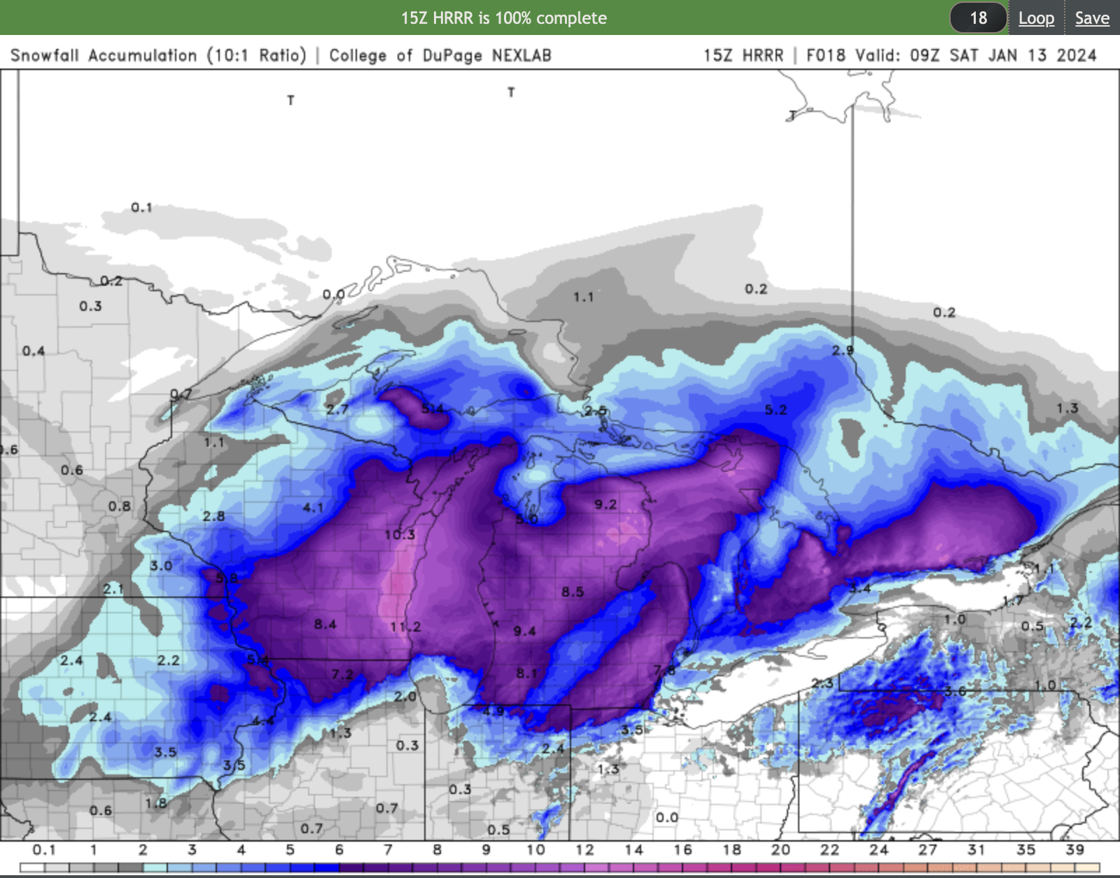
Don't lose hope - latest from GRR: .UPDATE... Issued at 1150 AM EST Fri Jan 12 2024 The 12Z DTX sounding was very dry below 700 mb with a dew pt depression of 15C noted at 850 mb. That dry air has been fending off snow to some extent this morning but that should not last too much longer given the very strong moisture influx arriving from the south this afternoon ahead of the approaching low. Snow has been developing across northern Indiana and far southern MI with 1/2 mile or less vsbys noted at BEH and SBN and some very encouraging/increasing radar trends are occurring farther south... south of IND. So while recent GRR radar trends are not very impressive and the dry air erosion could continue for another few hours, do not be fooled. The widespread, heavier snow will still all come together by 4 PM, with inch per hour rates snowfall still anticipated between roughly 4 PM and Midnight. Ensemble guidance remains quite strong in this regard so there are no changes to the forecast at this time. Mid level dry punch arrives from the south after 10 PM or so and brings a temporary diminishing trend before additional snow showers redevelop and intensify late tonight/early Saturday around the southern portion of the upper low. Winds will also become relative lighter during the snowfall coverage/intensity lull later tonight when the baggy pressure pattern with the sfc low/occlusion will be overhead... before cranking up again Saturday morning as the low lifts north.
-
Looks like a dry slot running through mid and SE lower MI in the latest HRRR
-
Enjoy it! Very surprised you don't have a blizz warning...
-
GRR went with a Winter Storm Warning but they did include guidance on lake effect in their AFD: - Significant Lake Effect Snow Saturday Night into Sunday As the winter storm pulls away from the region on Saturday, deep moisture wrapping around the back side of the system and rapid Arctic air advection into the region will set the stage for impactful lake effect snow. The immediate transition to lake effect snow will result in little to no ability to recover from the winter storm impacting the region Friday into Saturday for at least the western half of Lower Michigan. Moisture depth for this lake effect event will be exceptionally high at 25k ft deep along with significant lift through the DGZ, occurring as 850mb temperatures crash to around -20C. Winds gusting 20-30 mph inland and around 40 mph at the coast will ensure areas of blowing and drifting of the powdery lake effect snow. We are expecting many of these impactful bands to push well inland across the state given low level flow of 30-35 kts. The NAM12`s orientation of lift in the DGZ combined with some surface wind convergence occurring as cold air wraps around the southern portion of Lake Michigan has the look of an I-96 to I-94 dominant band of snow and blowing snow, prolonging treacherous travel conditions across highways and interstates from Saturday night into Sunday afternoon. This is in addition to significant snow showers and impacts up and down the lakeshore region with no time to dig out from the outgoing winter storm. Model QPF over this 24-hr period (00z Sunday to 00z Monday) from the ECMWF as well as the NAM12 is ranging from 0.25"-0.50", which with snow ratios forecast to be 15:1 or a bit higher, would yield snowfall amounts of 4"-8" with localized amounts around 1 foot near and west of US 131. It should be stressed that accumulating snow will spread further inland than most lake effect events, potentially impacting areas such as Lansing with several inches.
-
GRR says they will issue updated headlines mid afternoon. Any chance of Blizzard warnings?
-
Yes indeed! We've had quite a few epic snow events recently. Had to cancel our ski trip to Boyne this weekend - don't want to drive or ski that wind. Might try for some nordic in the woods on Sunday or Monday.
-
Though you all might find this interesting, apparently the HRRR was f'd up for two years due to a programmer error in setting the elevation of Lake Michigan: https://www.woodtv.com/weather/ask-ellen/ask-ellen-did-years-of-forecasting-suffer-due-to-lake-mi-level-being-set-at-sea-level/
-
Pre-Christmas (Dec 21-23rd) Winter Storm Part 2
Michigander replied to Chicago Storm's topic in Lakes/Ohio Valley
Merry Christmas from Grand Rapids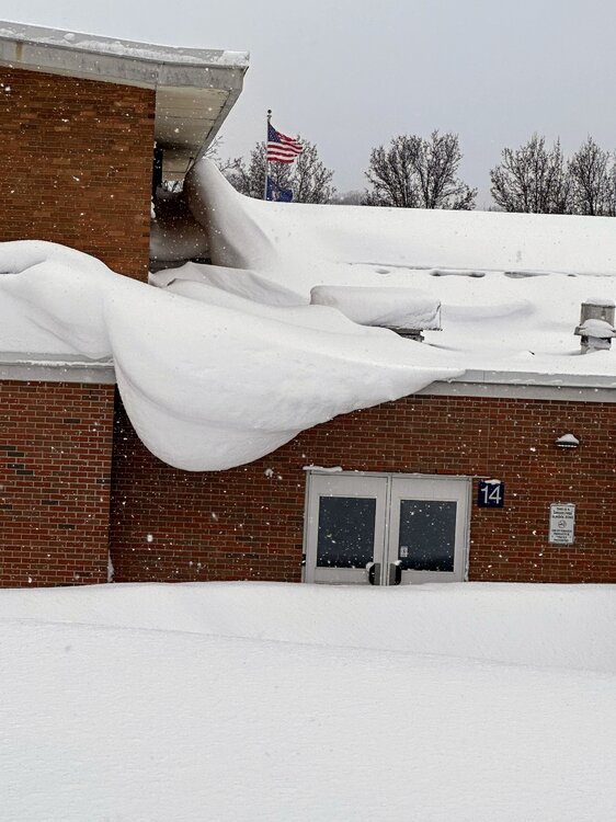
-
Pre-Christmas (Dec 21-23rd) Winter Storm Part 2
Michigander replied to Chicago Storm's topic in Lakes/Ohio Valley
I'm guessing no, if their reasoning is similar to GRR: We have issued a Blizzard Warning for our western 2 rows of counties and Winter Storm Warning for the eastern counties. This storm as two significant aspects, the unusably strong winds during a snow storm and the heavy snowfall, more enhanced lake effect snowfall as the system moves away from the area. We issued the Blizzard warning over our western counties for the combination of heavy lake effect snow and strong winds. We went only with a Winter Storm warning over the eastern counties since the snowfall was less during the time of high winds, meaning it seems questionable that we`d get the visibilities to stay below 1/4 mile for 3 consecutive hours. -
Pre-Christmas (Dec 21-23rd) Winter Storm Part 2
Michigander replied to Chicago Storm's topic in Lakes/Ohio Valley
Let's go
-
Pre-Christmas (Dec 21-23rd) Winter Storm Part 2
Michigander replied to Chicago Storm's topic in Lakes/Ohio Valley
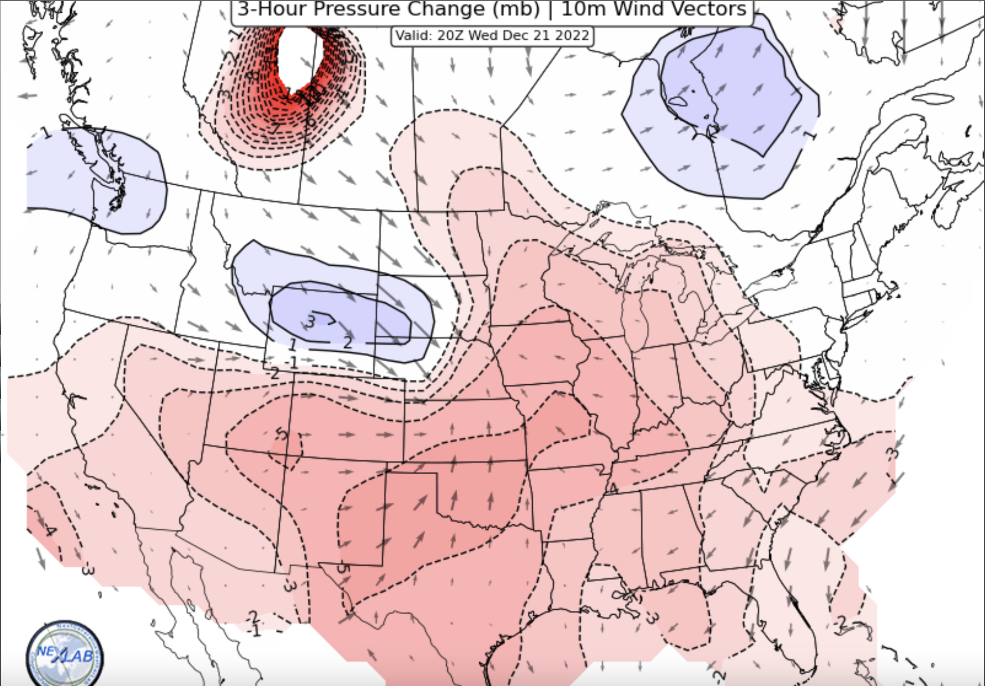
GRR going with blizzard warnings for those of us on the west side National Weather Service Grand Rapids MI 1217 PM EST Wed Dec 21 2022 LATEST UPDATE... Update .UPDATE... Issued at 1217 PM EST Wed Dec 21 2022 After coordinating with nearby offices, we are planning to issue a Winter Storm Warning for our eastern counties from Thursday evening until Saturday morning (likely 7 am). For our western CWA very likely we will issue a blizzard warning from Thursday evening through Saturday afternoon. The latest model trends over the past 3 runs of those model have stopped backing off on QPF and continue to support the idea of sustained winds in the 25 mph range with gusts to 40 mph on Friday. So the reason to have a blizzard warning over the western counties is that there would be significantly more snow during the day on Friday to blow around then there would be over our eastern counties. -
Pre-Christmas (Dec 21-23rd) Winter Storm Part 2
Michigander replied to Chicago Storm's topic in Lakes/Ohio Valley
Kind of misleading that his screen shot represents less than half of the totals that the NAM actually shows through Saturday IMBY. -
Pre-Christmas (Dec 21-23rd) Winter Storm Part 2
Michigander replied to Chicago Storm's topic in Lakes/Ohio Valley
GRR NWS is suggesting 15-20 to 1 ratios? -
Pre-Christmas (Dec 21-23rd) Winter Storm
Michigander replied to Chicago Storm's topic in Lakes/Ohio Valley
I seriously wish we could share some of this snow with you all. In my back yard we've gotten about 43" of lake effect already this year. My roof needs a break. -
Pre-Christmas (Dec 21-23rd) Winter Storm
Michigander replied to Chicago Storm's topic in Lakes/Ohio Valley
GRR from last night -
Winter 2022/23 Lake Effect Snow Thread
Michigander replied to Chicago Storm's topic in Lakes/Ohio Valley
Heavy snow again now in GRR, sending your way. Radar is lighting up. -
The NHC called it landfall at Captiva, not me https://www.nhc.noaa.gov/text/refresh/MIATCUAT4+shtml/281557.shtml?