Burghblizz
-
Posts
1,742 -
Joined
-
Last visited
Content Type
Profiles
Blogs
Forums
American Weather
Media Demo
Store
Gallery
Everything posted by Burghblizz
-

Western Pa / Pittsburgh area Winter Discussion ❄️☃️
Burghblizz replied to north pgh's topic in Upstate New York/Pennsylvania
Euro has that intial heavier band setting up just south. Eventually evens out a bit. This all would require clean front end and a prolonged back end - but looks very much in play. Love the relative wide swath everywhere
-
Western Pa / Pittsburgh area Winter Discussion ❄️☃️
Burghblizz replied to north pgh's topic in Upstate New York/Pennsylvania
Shows about 1.3” QPF too. Its still a little dicey with temps - but has a 12” bullseye in NE AGC. More slop to the south -
Western Pa / Pittsburgh area Winter Discussion ❄️☃️
Burghblizz replied to north pgh's topic in Upstate New York/Pennsylvania
If you were hoping for some coastal love, the NAM won’t disappoint. Fires like 20” back to Indiana county - Everywhere else around AGC foot-ish. Still trying to mix south a bit -
Western Pa / Pittsburgh area Winter Discussion ❄️☃️
Burghblizz replied to north pgh's topic in Upstate New York/Pennsylvania
Euro looking close to that same 8-9” type output in the city or just south - but instead of the snow hole over Morgantown, it has a 12” bullseye. And the totals trail off from the city north. This really shows some of the complexity with track, temps, and the dry slot (which could hurt those borderline temps, in addition to less precip. So double whammy where that happens). I think Euro overall is a slightly better look for us since the dry slot seems to be in central WV. So more wiggle room as long as that shear to the NE doesn’t get us -
Western Pa / Pittsburgh area Winter Discussion ❄️☃️
Burghblizz replied to north pgh's topic in Upstate New York/Pennsylvania
I have a feeling beyond 84, that little screw zone would catch up a bit. -
Western Pa / Pittsburgh area Winter Discussion ❄️☃️
Burghblizz replied to north pgh's topic in Upstate New York/Pennsylvania
Looks 12z Euro-ish. Exception might be some mixing in the middle, but looks like still a solid fetch of moisture going at the end. -
Western Pa / Pittsburgh area Winter Discussion ❄️☃️
Burghblizz replied to north pgh's topic in Upstate New York/Pennsylvania
We’ve heard for years not to study the NAM at 84...but I’m gonna. Def south, but almost looks like it wants to force that intial heavier snow south, and/or have it fizzle sooner. Im OK with that look at this point - just seems like mixing is the bigger concern than full suppression -
Western Pa / Pittsburgh area Winter Discussion ❄️☃️
Burghblizz replied to north pgh's topic in Upstate New York/Pennsylvania
The key for that could be that 1034 high. Was slightly south of 0Z as the run progressed -
Western Pa / Pittsburgh area Winter Discussion ❄️☃️
Burghblizz replied to north pgh's topic in Upstate New York/Pennsylvania
Euro is colder with a more robust strip of 12+ streaking through central Ohio. That was less pronounced at 0z, and basically makes it all the way to Pgh now. i think it’s the result of a slightly further south track of the primary. -
Western Pa / Pittsburgh area Winter Discussion ❄️☃️
Burghblizz replied to north pgh's topic in Upstate New York/Pennsylvania
A lot could definitely go wrong. Not sure we have an analog with a good storm that cuts that far west, and then hits a brick wall and slides east in time to 1) give us heavy precip and 2) not pull warm air in. That makes it a little more thread of the needle. I will say the nightmare snow hole scenario looks less likely -
Western Pa / Pittsburgh area Winter Discussion ❄️☃️
Burghblizz replied to north pgh's topic in Upstate New York/Pennsylvania
I would say so!
-
Western Pa / Pittsburgh area Winter Discussion ❄️☃️
Burghblizz replied to north pgh's topic in Upstate New York/Pennsylvania
I seriously considered going to the Poconos (free condo) or Breezewood (close drive) for the 12.16 storm. I mean real close to going. I think I wound up with more snow staying put. So hopefully this comes back to us as well. -
Western Pa / Pittsburgh area Winter Discussion ❄️☃️
Burghblizz replied to north pgh's topic in Upstate New York/Pennsylvania
Seeing 3” in places like Cannonsburg and Mt Lebanon -
Western Pa / Pittsburgh area Winter Discussion ❄️☃️
Burghblizz replied to north pgh's topic in Upstate New York/Pennsylvania
There was definitely some model support for a couple inches this morning, but didn’t make it into the forecasts. So in that way, a nice surprise -
Western Pa / Pittsburgh area Winter Discussion ❄️☃️
Burghblizz replied to north pgh's topic in Upstate New York/Pennsylvania
I keep thinking how many times we have said in the past that we would trade in a ton of nickle and dime snows for a few good thumps a year. Looks like we got our wish :-) While I do prefer thatI am starting to miss snow and our usual cadence of it. -
Western Pa / Pittsburgh area Winter Discussion ❄️☃️
Burghblizz replied to north pgh's topic in Upstate New York/Pennsylvania
I think that is generally correct. Especially in our area where it seems to underestimate warm air advection. So when that is the driver of snowfall, it’s going to underestimate it. When it leads to mixing issues, it also of course underestimates that. The why’s are above my pay grade. The mesoscale models with smaller grid spacing pick up more local nuances and thus are more accurate in the short team -
Western Pa / Pittsburgh area Winter Discussion ❄️☃️
Burghblizz replied to north pgh's topic in Upstate New York/Pennsylvania
Great start to winter! The Euro and NAM were good at showing the possibility of a prolonged period of snow. Got to love closed lows and negatively tilted troughs in these parts. I still saw flakes even this morning. I don’t necessarily consider any of these 3 events overachievers per se. The model support was definitely there for these amounts. It’s just nice to have the digital snow translate to real snow. That’s been a problem the last few years -
Western Pa / Pittsburgh area Winter Discussion ❄️☃️
Burghblizz replied to north pgh's topic in Upstate New York/Pennsylvania
NAM picked up on the prolonging of the snow into this afternoon. I feel like this is the type of fluffy snow that will add a sneaky inch or two if it continues. Wouldn’t be suprised to see an event total pushing 6” The average yinzer with a ruler probably won’t report that much since it might not add much to the depth as last nights snow settles. But with NWS likely clearing their board every 6 hours, they will report > 6” -
Western Pa / Pittsburgh area Winter Discussion ❄️☃️
Burghblizz replied to north pgh's topic in Upstate New York/Pennsylvania
Merry Christmas! Looks like officially 4.5”, with 3” after midnight Probably the opposite of the last storm as Moon likely does a little better than city and points east. -
Western Pa / Pittsburgh area Winter Discussion ❄️☃️
Burghblizz replied to north pgh's topic in Upstate New York/Pennsylvania
Not sure if it was more the flash freeze or a period of freezing rain, but everything was quickly covered in ice. Mod snow/sleet mix right now with a dusting on top of the ice. Quite windy -
Western Pa / Pittsburgh area Winter Discussion ❄️☃️
Burghblizz replied to north pgh's topic in Upstate New York/Pennsylvania
Intellicast is pretty much weenie radar because its pretty sensitive and makes snow shields look huge - but I find its pretty good in outlining R/S lines -
Western Pa / Pittsburgh area Winter Discussion ❄️☃️
Burghblizz replied to north pgh's topic in Upstate New York/Pennsylvania
GFS is more progressive than the NAM, but both get to about that 5” to 7” range E to W. NAM has it snowing about 6 hours later into Christmas Day. The upper levels have a closed low with negatively tilted trough. Might be a good sign that this meanders a bit as opposed quickly sliding away. -
Western Pa / Pittsburgh area Winter Discussion ❄️☃️
Burghblizz replied to north pgh's topic in Upstate New York/Pennsylvania
NAM is maybe a tick west with the heaviest axis, but similar for us to 18z (which was more robust than 12z) -
Central PA - Winter 2020/2021
Burghblizz replied to MAG5035's topic in Upstate New York/Pennsylvania
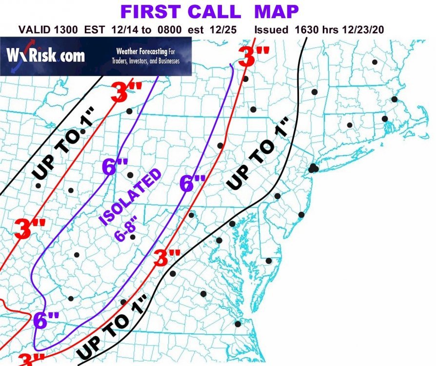
I think he has been doing it that way close to 20 years. The intent is to look at the lines and project based on what lines u are between and/or near. But you are right, those gaps can get pretty tight in some areas, plus he goes from <1 straight to 3 in this case. So if you are 20 miles east of the 3” line, no clue if he is thinking “almost 3” or “under 1”. Then you hit the 6” line 30 miles the other way Plus it doesn’t account for local climo factors. Much better ways to present it these days. -
Central PA - Winter 2020/2021
Burghblizz replied to MAG5035's topic in Upstate New York/Pennsylvania
Tolleris is a bit east of most guidance, but he thinks true central has a shot for significant snow