

Burghblizz
-
Posts
1,432 -
Joined
-
Last visited
Content Type
Profiles
Blogs
Forums
American Weather
Media Demo
Store
Gallery
Posts posted by Burghblizz
-
-
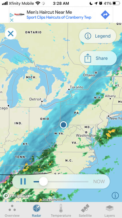
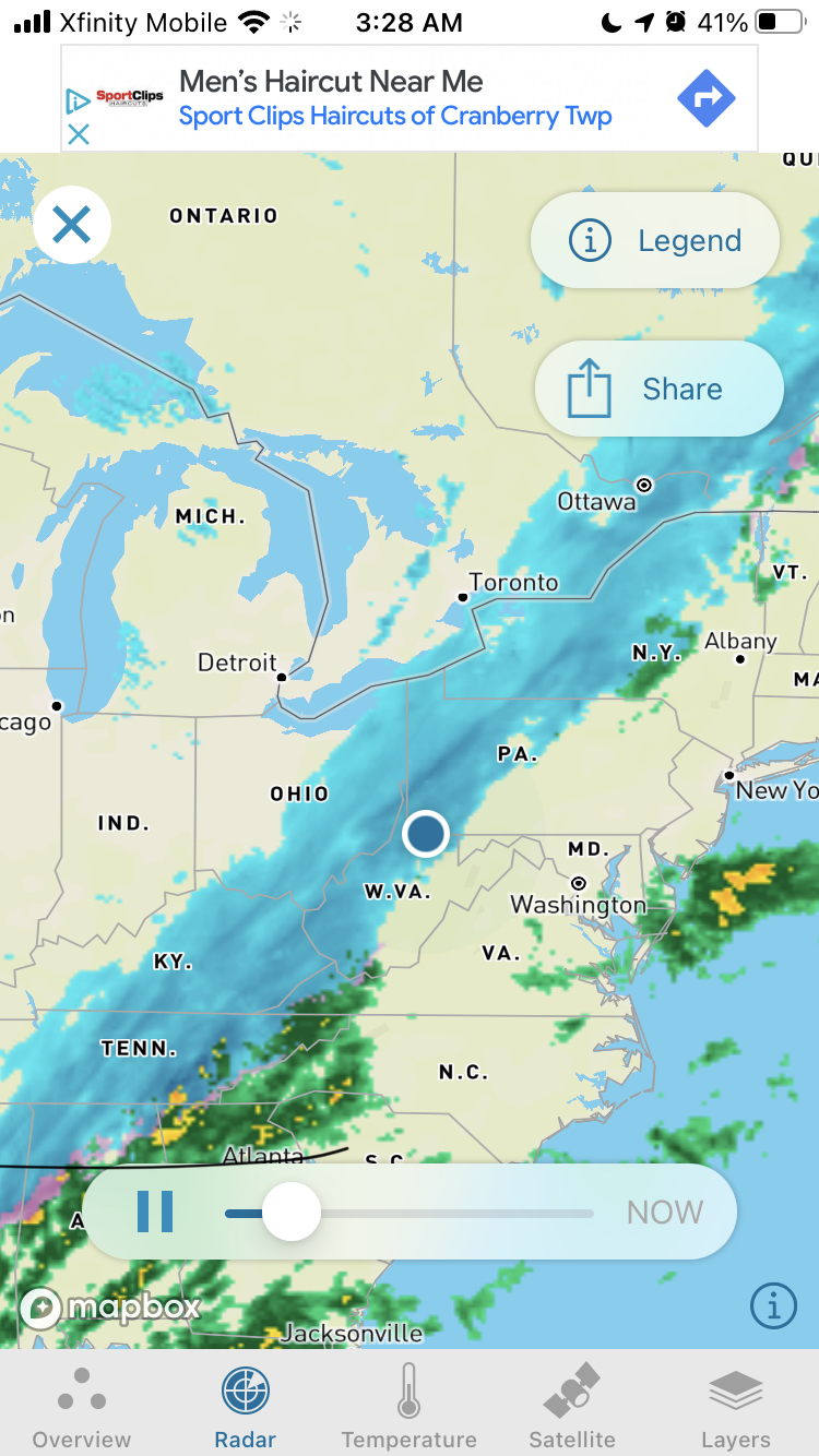
NAM isn’t great for central and southern AGC - but not a complete disaster. Still looking decent northern AGC and Butler. Southern Border counties look in trouble.
The one improvement was more moisture to the west, so anyone on the good side of the changeover has a little more time to work.
(I know - could just mean staying sucked in longer)
-
Wanna see if the NAM holds on before completely throwing it in.
-
 1
1
-
-
9 minutes ago, jwilson said:
The CMC is the only one of the majors that keeps it an open wave, meaning the lows - at all levels - never close off. So the s/w doesn't deepen and it bounces along the confluence out to sea. It's subtle, but it is also a tad bit stronger and further south / faster with the confluence. There's a suppressive element to that difference.
There's not a ton of NS energy getting phased into the center in any case. The good and bad of that is we have a cap on how far north it can realistically go, but it also means we cap how deep the storm can intensify. Most of that energy acts more of a kicker to knock the system East, which also means the center of LP stays farther away and limits its influence on us.
Obviously, we're coming into this event with extremely marginal cold air. It's going to be 50 degrees Monday. In a system like this, that doesn't matter quite as much, but the antecedent thermals are always relevant to some extent. Both the Euro and GFS are now keeping the better totals north of PIT metro.
Based on experience, I think I see enough red flags to bail on this one, at least here in the South Hills. I'll be happy if I'm wrong, but I would honestly be quite shocked to see this one come back south and bullseye the Pittsburgh localities. That would go against conventional wisdom.
Not saying it's impossible, but I'm playing the odds here - if you're into betting, it's like taking the favored home team.
Good write up. The only thing that feels different to me is how far south the NAM and Ukie are (with Canadian being a non storm). Gives me at least some hope that the final solution ticks back south instead of the other way.
-
Euro looking like the GFS did yesterday. 8” IMBY….but AGC is the battleground with a rapid drop off.
-
26 minutes ago, TimB said:
GEFS mean looks awesome.
Was just looking at that. Could be another sign that the it’s GFS Op versus the world.
-
1 minute ago, TimB said:
And just like that, it’s gone on the GFS.
That was the Canadian being contrasted to the GFS. GFS is just too amped up.
-
7 minutes ago, CoraopolisWx said:
It does seem a bit odd how the gfs moves the low due north that far before transferring.
If that were the only model I saw, I would think we were in for a plain rainstorm, and somewhere between Columbus and Detroit eventually gets nailed. GFS usually doesn’t tick SE in this range.
NWS doesn’t seem to be buying it. The non-event scenario would be more due to a progressive, weaker storm that doesn’t tap any cold air (as opposed to a larger one that charges north). Probably won’t have a great idea for 24 hours.
-
Real nice discussion. We normally call it out when they mail it in too, but that’s a good one
-
22 minutes ago, Bubbler86 said:
Back when these types of forums covered larger areas, there was a lot of angst since what is good for one is not for the other. People in NYC and NE would hate on MA people when cheering on a storm that missed NYC to the south. Since all areas of the East US were posting in the same thread it was tough to not have people get mad. Glad you guys do not hate when we root for a situation that may leave you dry.
The old live model threads were nice because there were 4 or 5 Mets chiming in live on what they were seeing. But then weenies would jump in saying things like “it’s coming north!, just because the QPF shading over their house ticked north. Meanwhile, the storm was the other direction. At one point, non-red taggers got banned from them.
It’s better now in terms of focused content, but back then you would have more interaction with a larger group (which, yes, sometimes led to fights
 )
)
-
2
-
-
7 minutes ago, blackngoldrules said:
Not sure if I've ever seen the models this far apart this close to a potential storm. I guess still a lot of uncertainty how this is going to set up and such a high margin of error. Whoever gets the big snows from this is going to be lucky. I'm starting a new job on Tuesday. Would be my luck if THIS one would happen to nail us! Lol
Sent from my SM-G991U using Tapatalk
I’ll take it since you guys got the lake band
 . But yeah, it looks like up in the air not only regionally, but locally. Wouldn’t be shocked if it was another one that split our area in terms of impact. Model biases seem out the window too.
-
1
-
-
4 hours ago, CoraopolisWx said:
18z is even more extreme with the cutoff. During the transfer we could have pockets of different 850 temps, similar to last months morning slush event.
I’m on the good side of that cutoff, but it’s tight. Hopefully 0Z shows that swath a tick south.
-
NAM has 6”+ and still snowing at 84. Certainly not a bad sign
-
12z….GFS taken literally has more snow than the Euro IMBY… but that look scares me. This will probably flip flop a few times by Sunday, so going to try to put it down for 24 hours
")
-
55 minutes ago, Rd9108 said:
18z gfs has some snow showers atleast. Just gets going a little too late

The way this winter has gone, I’d sign now for the 5” IMBY with the possibility for more chances the second half of the month.
-
Less brutal cold, but more snow on average when looking at more than the last 15 months. Not all that horrible.
So now that we’ve established that it’s been a mild winter, time to focus on a potential pattern flip.
-
1 hour ago, jwilson said:
We're still really a week to 10 days out from determining the extent of the pattern change. By that point, we'll be much closer to the transition period to see if things still progress as long-range guidance implies. Ensembles haven't budged much.
The mid-week Omega Block didn't work out because we basically have a double-ridge that moved too far to the East, which blocks the trough out into the western Atlantic. Sort of a trend this year - we can't get the boundary interaction and timing exactly where we want it.
We'll have to deal with at least one cutter, I would think, before the shift in the block and jets.
Right now it's just a waiting game.
Good assessment. I’m going to try to enjoy some longer walks with the dog, and hope for a kick ass final 5-6 weeks.
-
2
-
-
1 hour ago, jwilson said:
I'm repeating myself a bit here, but my expectations for this winter were set at 30" based on historical analogs. That was basically the ceiling for Pittsburgh during +2.0 Nino events (we peaked at +1.9, I think, but that's hair-splitting). It's a below average winter for us, by far, but since my expectations were relatively low, I'm not too surprised by how things have gone. My only inkling was that maybe we'd hit a big storm this year - and that would essentially be the source of most of our season's snowfall. I'm generally fine with such an outcome.
The eight years it has been since a 20" storm is the longest I've gone in my life not seeing something of that magnitude.
It's obvious by now that this wasn't going to be a wall-to-wall winter with infinite opportunities. I guess chances might favor we get a repeat of January with a 14-day threat window where cold and precipitation align. Like you, I don't necessarily care as much once we get into March, but March is quite capable of producing big winter events. Just two years ago Pittsburgh got >17" in March, but someone will have to fill in the blanks for me because I don't remember how that happened (2022 was a weird year for me). Pittsburgh's biggest storm ever was in March, of course, but I guess since that was such a fluke thing it's mostly irrelevant. Only point being that even if we end up moving the window later in February or back into March, there's still chances to be had. Our window is open a bit longer than places south and east.
March ‘22 had an 8” ish storm around around the 12th, and then a very active LES pattern even into the latter part of the month. So it was a good month, although lots of melting in between events. But hey, it was March.
Other thing I remember is someone (I think Ahoff) started a spring thread in February since it was sucking. Must have worked as a reverse jinx as we finished strong. Threaded the needle nicely on the bigger storm as this long area of precip trained for awhile
-
 1
1
-
-
Funny how the NAM is a cold outlier. Not sure if maybe it’s overdoing the rates leading to more dynamic cooling. But it’s been consistently showing that backend snow.
-
12 minutes ago, mitchnick said:
Lol euro
You made me look. I’d be happy to wait 9 days for a 970mb retrograding bomb.
-
1
-
-
NAM is most aggressive with a period changing to snow tomorrow. Has been liking North and West of city. Taken literally, about 4” at KPIT. Probably won’t be able to thread the needle like that, and surface temps will likely be above freezing. Something to watch though.
-
1 hour ago, TheClimateChanger said:
Nah, DuBois is more central than western. The airport just happens to be over the border in Jefferson County, so it falls within NWS Pittsburgh's CWA.
Maybe just start your own thread where you can dump whatever statistics you want for wherever you want. If it’s the warmest day that the neighbors dog took a shit facing south, you don’t have to worry about it being irrelevant.
-
1
-
-
1 minute ago, CoraopolisWx said:
Still doing the research, but it seems the snowfall droughts are increasing.
Yes, overall our average annual snowfall has increased these past 20+ years, however these past 10 years especially, we can go 15-20 days in between snowfalls 0.1" or more.
In the past that number was never more than 8-10 days.
That would be surprising. Because it feels like we got our snows in smaller chunks over the last 20 years (with a few big exceptions like 2.10 and 12.20). That would in theory need more frequent snows to keep the averages up.
-
Just now, KPITSnow said:
But I also think it is relevant. I don’t think you can argue that winters have been overall warmer. You also can’t argue that the lakes used to regularly shut off for LES by January as they froze but really don’t anymore. We hadn’t had a true Alberta clipper in years here.
I don’t know how all these things tie together, but they are very relevant to our local discussion
You’re not wrong. Fewer clippers, more flirting with mix. There have been subtle changes. Maybe offset by more extended LES nuisance snows. But I think 2023 is a blip. There have been plenty before.
Talking warm temps last night and today is very relevant. But Dozens (if not hundreds) of posts that build towards some narrative that our overall snow is dying is the clutter I’m talking about. Nothing in the long term data shows that.
-
27 minutes ago, KPITSnow said:
I know. The response to what is a meteorological fact, which we discuss on here, was way over the top and shows how unfortunately politicized science has become
Funny how you think you understand my “politics”. Definitely a different person than your “assumptions”, and not in any way disputing the science.
I’m just sick of a formally great thread cluttered with it when…again…local sensible weather will go through cycles.
-
1
-
Pittsburgh, Pa Winter 2023-24 Thread.
in Upstate New York/Pennsylvania
Posted
Kuchera actually a little more robust. Brutal cutoff though