Festus
-
Posts
689 -
Joined
-
Last visited
Content Type
Profiles
Blogs
Forums
American Weather
Media Demo
Store
Gallery
Everything posted by Festus
-
Another Tornado Warning north of Bel Air MD moving northeast. Might wander into southern Lancaster County. Edit: Just dropped, thank goodness.
-
Watch issued down this way. It is a rare day when a Tornado Warning is issued without a Watch in place prior to.
-
Todays high of 50 in Millersville would be the record low high temp if it were yesterday or tomorrow. But alas, today record low high temp is 46 so no soup there. But good lawd, it is butt ugly outside (I believe that is the official term). 3.29" storm total so far.
-
Millersville was close to a record low maximum temperature for the day. Record is 44 set in 2003, today reached 46. Gotta think there are a few record low maxes out there somewhere.
-
SPC has most of us in the Slight Risk zone for tomorrow: Farther north across the Mid-Atlantic, the severe threat should increase along and ahead of the cold front, which is expected to move through during the late afternoon and evening. Modest instability should develop ahead of the front amid filtered daytime heating and cooling mid-level temperatures. Low to mid-level flow across this region will remain strong. The resulting combination of modest buoyancy and robust vertical shear should result in the development of isolated strong to severe storms. Damaging winds are the primary threat, but low-level vertical shear is strong enough to support a tornado or two. Some marginally severe hail may also occur.
-
WWA was extended down this way but temp is 36. DP is 17 so some cooling is likely. Gonna be close.
-
Looking at all time monthly temperature record high/low for Harrisburg, the largest range is: 1. January - 95 degrees (high = 73, low = -22) 2. February - 92 degrees (high = 79, low = -13) 3. March - 88 degrees (high = 87, low = -1) If we throw in wind chill this AM, we're probably looking at 60 degrees this WEEK (low wind chill today = 10, high temp Thursday = 70). March indeed.
-
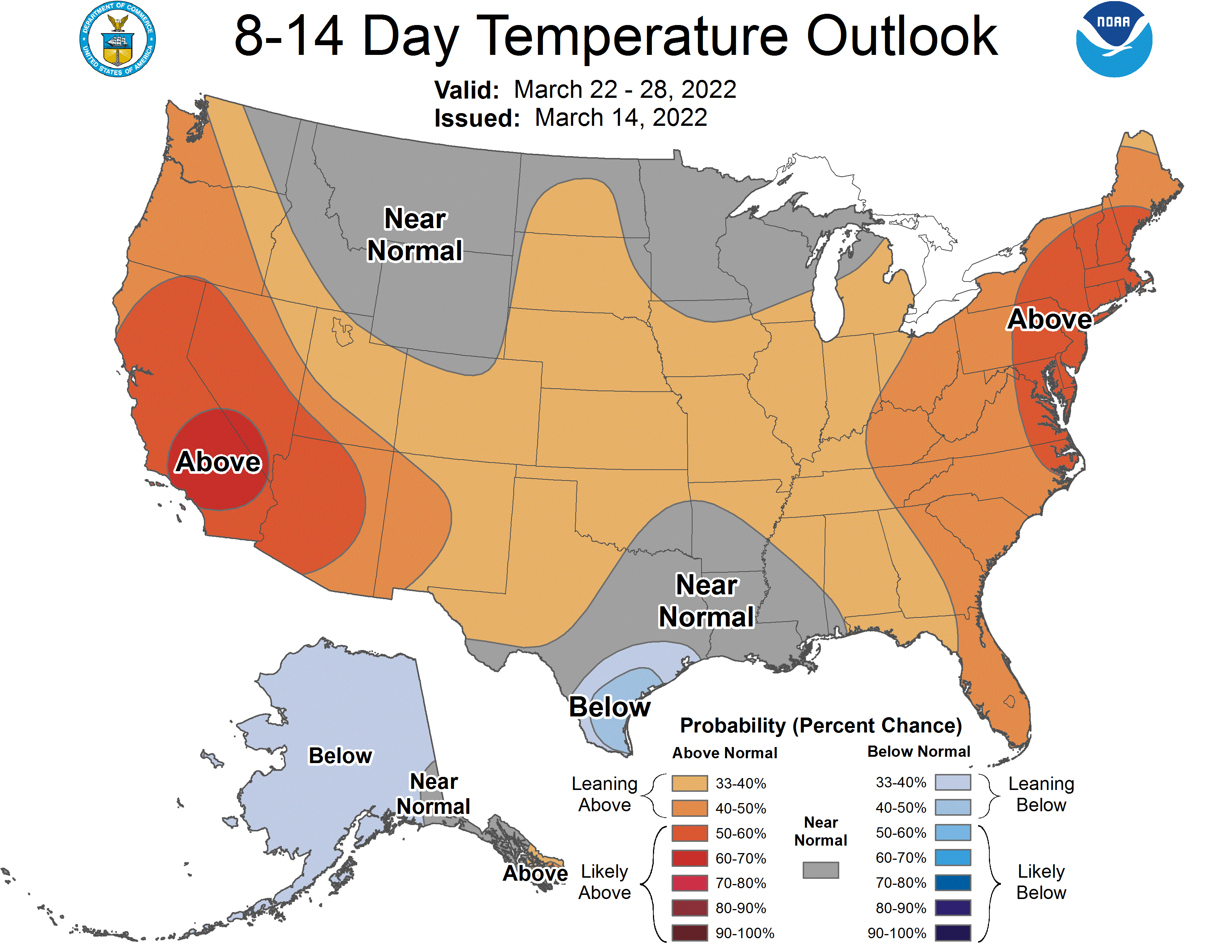
Latest CPC 8-14 day issued today has us a bit on the warm side.

-
Interesting how you construed my posting of the legislation as an endorsement. I personally like to do more evening outdoor activities when the weather is warm but can't say I would look forward to darkness so late in the AM over winter. At the risk of incurring Canderson's wrath, I actually like things as they are.
-
Today marks the greatest difference between clock noon and solar noon. The sun reaches its zenith at 1:14 PM today for a 1 hour and 14 minute difference. The difference tweaks shorter going forward. There is another federal legislative attempt at eliminating Standard Time - this one sponsored by Whitehouse (D) and Rubio (R) and titled the Sunshine Protection Act (how cute). Who knows, maybe this is the last time we spring forward.
-
283E is closed at Cloverleaf Rd. Traffic map has a lot of slow-go on the N-S roads where crosswinds must be wreaking havoc. (Edit: Canderson wins the 283 closure sweepstakes by a minute.)
-
SPS Issued by CTP: PAZ028-036-041-042-046-049>053-056>059-063>066-121915- Southern Lycoming PA-York PA-Sullivan PA-Union PA-Franklin PA- Northern Lycoming PA-Lebanon PA-Juniata PA-Dauphin PA-Snyder PA- Columbia PA-Perry PA-Lancaster PA-Northumberland PA-Adams PA- Cumberland PA-Montour PA-Schuylkill PA- 100 PM EST Sat Mar 12 2022 ...HEAVY SNOW BAND... HAZARDS...A band of heavy snow accompanied by winds of up to 35 MPH which can rapidly reduce visibility to less than a quarter of a mile. This band of heavy snow is producing very heavy snow at the rate of 1 to 2 inches per hour. LOCATION AND MOVEMENT...At 1259 PM EST, the leading edge of a band of heavy snow was along a line extending from Wyalusing to 14 miles north of Berwick to near Danville to Linglestown to near Hanover and moving east at 65 MPH. THIS BAND OF HEAVY SNOW WILL BE NEAR... Bloomsburg, Slabtown and Numidia around 105 PM EST. Shumans, Cleona and Lickdale around 110 PM EST. Lebanon, Berwick and Nuremburg around 115 PM EST. Myerstown, Shrewsbury and Glen Rock around 120 PM EST. Red Lion, Cross Roads and Stewartstown around 125 PM EST. Brogue around 130 PM EST.
-
Good stuff! Shows all the factors involved in managing roads conditions and deploying assets accordingly.
-
Interesting theory. I think it is some of both. I have a paver checkerboard beside my driveway and dark ones are clear, the light ones still have snow. They are not that thick so unlikely the darker ones retained heat for an extended period of time.
-
Today is the sun equivalent of September 30th. Amazing how much solar radiation makes it through even the thickest cloud deck.
-
Confirmed here as well. Maybe 3" max on the grass and it's like a snow mist at the moment. Not accumulating. Plow went through so even my neighborhood road is just wet at the moment. Radar versus reality are two different things here.
-
<1/4 mile visibility. Neighborhood roads caved. 31.9F. Golf outing this Friday where jacket may be optional. Crazy stuff.
-
Since it appears true weather related topics may be limited in the next week, here's one from one of my favorite subjects - daylight. As of today (for Lancaster), we cross the 12 hour threshold for civil twilight. It is defined as - "Civil twilight is the brightest form of twilight. There is enough natural sunlight during this period that artificial light may not be required to carry out outdoor activities. Only the brightest celestial objects can be observed by the naked eye during this time. Several countries use this definition of civil twilight to make laws related to aviation, hunting, and the usage of headlights and street lamps."
-
Wow. What a difference up there. Fingers crossed for a good outcome. Will be like watching Heavy Rescue on the Weather Channel.
-
Just like y'all, temp down to 31.5, visibility roughly 1/4 mile at peak, improving now. In terms of accumulation, looks like the grass has dandruff. Roads wet. That's about it.
-
Definitely weakening as its traversing Harrisburg. Must be all the ground resistance of the tall buildings .
-
Special Weather Statement issued down this way. No Squall Warning .
-
Sure looks like a burly one. Temp here is 41 so if it holds together, we'll see if anything can lay. I think roads just get wet.
-
Full moon tonight. And the full moon in February is termed the "Snow Moon". Oh the humanity...
-
Adding to the theme, I'm maybe a dozen miles or so from you.