UpstateSCGamecock
-
Posts
45 -
Joined
-
Last visited
Content Type
Profiles
Blogs
Forums
American Weather
Media Demo
Store
Gallery
Everything posted by UpstateSCGamecock
-
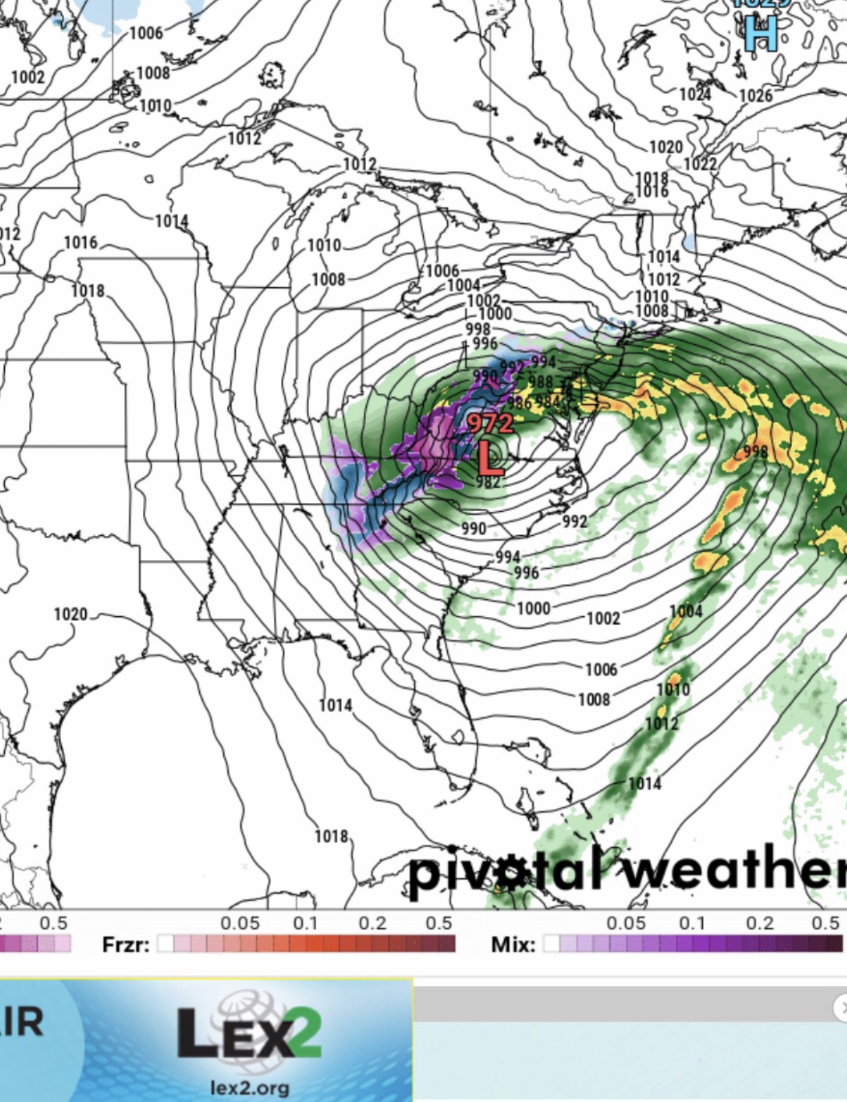
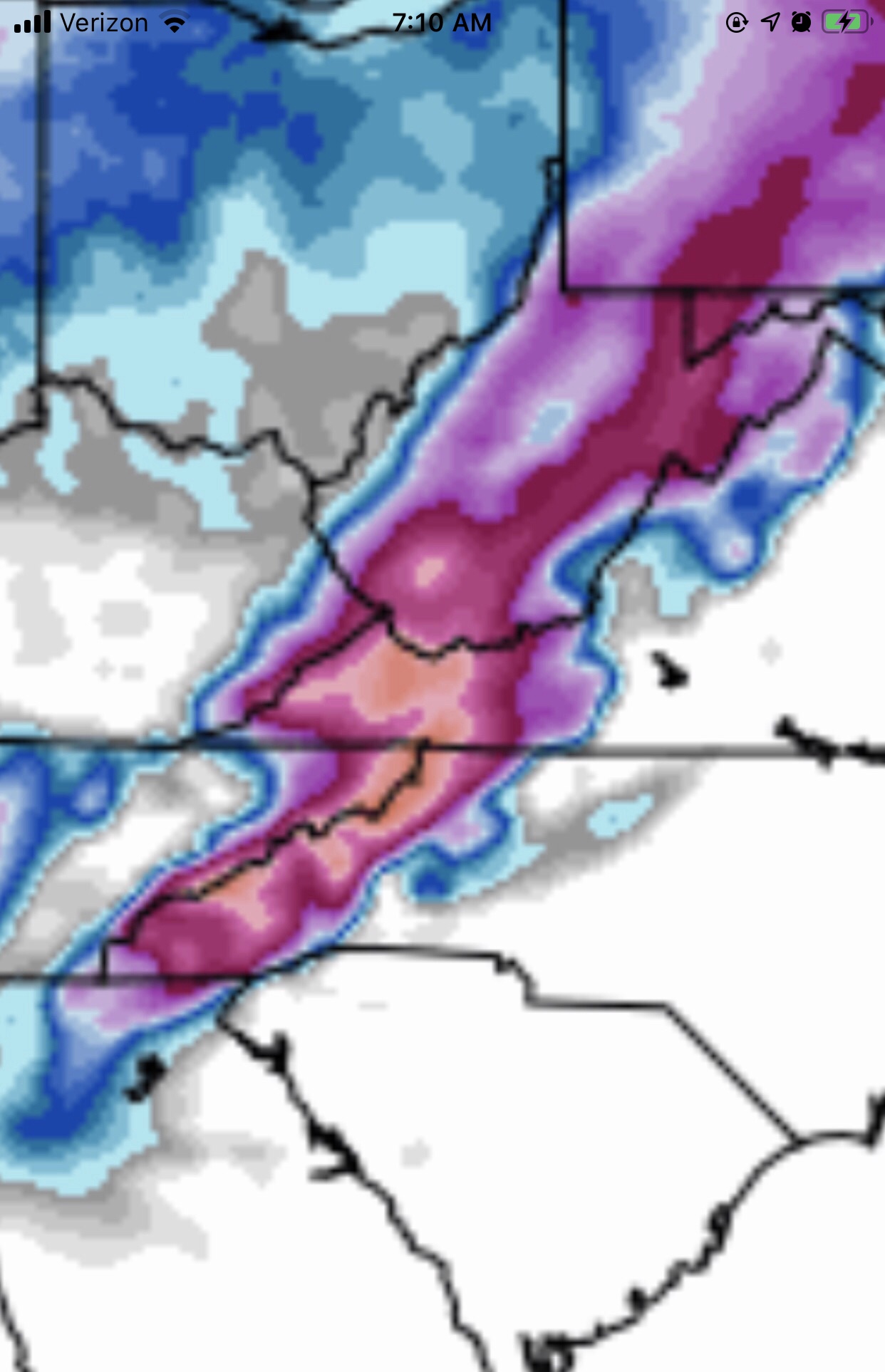
While the pattern is not optimal, I must point out that areas of NE GA got 7 inches and parts of SC 3+ in one of the most hostile patterns on 2.8.20. .
-
Discussion from GSP .LONG TERM /WEDNESDAY NIGHT THROUGH SATURDAY/... As of 315 am Sunday: The medium range will begin with chilly/drying high pressure building south through the forecast in the wake of the increasingly E/W oriented frontal zone. Global guidance suggests we are by no means out of the woods regarding the potential for resurgent moisture into the cool air mass in the Wed night/Thu time frame, as the 00Z GFS now redevelops precip (albeit primarily a very cold rain) across roughly the southern half of the area Thu morning. While the ECMWF remains considerably drier than the GFS, it nevertheless is trending in a wetter direction, with qpf response now depicted into the southern half of the forecast area Thu morning. Needless to say, small pops are retained in the forecast through the day Thursday, with mainly a mountain snow/Piedmont rain forecast, although the chance of wintry weather developing east of the mtns is certainly there if post-frontal precip does indeed develop. The remainder of the medium range looks dry and colder than normal. .
-
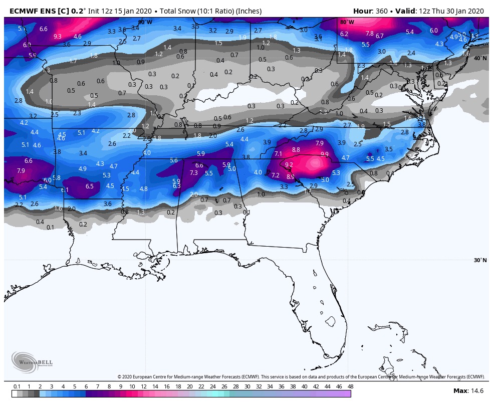
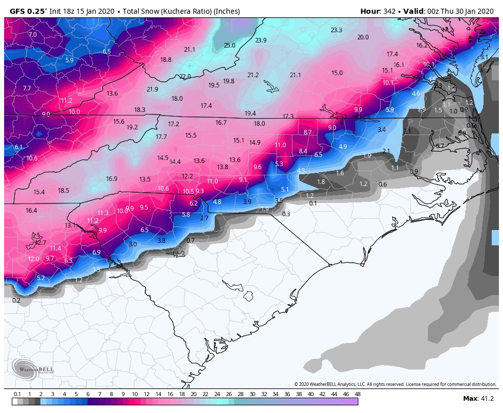
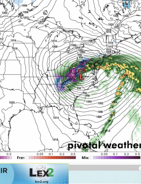
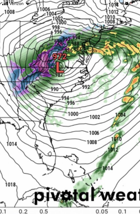
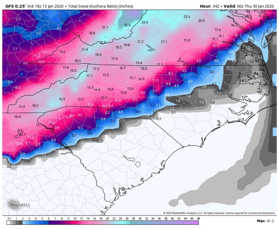
We know the faults of the GFS but it’s shown this storm signal for this date multiple times. Can we finally score? .
-
.


-
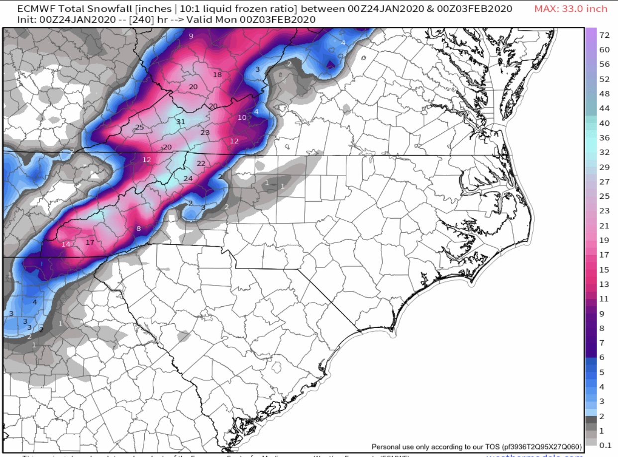
Euro Feb 2 WNC Bomb .
-
Agree. I just wanted to point out how both the GFS and Euro ENS match closely for 28th/29th storm threat. Yes, over 300 hours so it’s just eye candy. .
-
.

-

December 8-10, 2018 Winter Storm
UpstateSCGamecock replied to Orangeburgwx's topic in Southeastern States
It’s snowing in Clinton, SC. Thanks ULL. . -
December 8-10, 2018 Winter Storm
UpstateSCGamecock replied to Orangeburgwx's topic in Southeastern States
Will precip begin before sunrise or is this an afternoon event for the ULL in SC? . -
December 8-10, 2018 Winter Storm
UpstateSCGamecock replied to Orangeburgwx's topic in Southeastern States
While it’s still 33 in Clinton. We did get 1/2 of sleet from the storm. . -
December 8-10, 2018 Winter Storm
UpstateSCGamecock replied to Orangeburgwx's topic in Southeastern States
GSP’s discussion page doesn’t give much hope for snow south of 85 and they are not sure if frozen gets to advisory criteria. Your post gives me hope. Thanks for the informative posts for your neck of the words. That would bode well for me in S of 85 in SC. . -
December 8-10, 2018 Winter Storm
UpstateSCGamecock replied to Orangeburgwx's topic in Southeastern States
Any one care to discuss the cold air and dew points aligning up with reality as compared to modeling? Are we still on track? . -
December 8-10, 2018 Winter Storm
UpstateSCGamecock replied to Orangeburgwx's topic in Southeastern States
Upstate SC followers hope it’s correct. . -
December 8-10, 2018 Winter Storm
UpstateSCGamecock replied to Orangeburgwx's topic in Southeastern States
. -
Southeast Sanitarium - A Place to Vent
UpstateSCGamecock replied to Jonathan's topic in Southeastern States
He is living in TN. Still follow him on FB. . -
December 8-10, 2018 Winter Storm
UpstateSCGamecock replied to Orangeburgwx's topic in Southeastern States
Andy Wood Former Met Fox Carolina . -
Southeast Sanitarium - A Place to Vent
UpstateSCGamecock replied to Jonathan's topic in Southeastern States
Andy Wood FORMER Met for Fox Carolina . -
December 8-10, 2018 Winter Storm
UpstateSCGamecock replied to Orangeburgwx's topic in Southeastern States
Can you be specific about WYFF? Currently in TN but heading back to southern upstate today. . -
December 8-10, 2018 Winter Storm
UpstateSCGamecock replied to Orangeburgwx's topic in Southeastern States
Oh come on, please do. . -
December 8-10, 2018 Winter Storm
UpstateSCGamecock replied to Orangeburgwx's topic in Southeastern States
Can you share SC totals? . -
December 8-10, 2018 Winter Storm
UpstateSCGamecock replied to Orangeburgwx's topic in Southeastern States
How about that....upstate Mack special . -
December 8-10, 2018 Winter Storm
UpstateSCGamecock replied to Orangeburgwx's topic in Southeastern States
NWS Columbia SC .LONG TERM /FRIDAY NIGHT THROUGH TUESDAY/... The main concern during the medium-range period is a possibility of a wintry precipitation mix. Surface high pressure will extend from the Midwest into the mid- Atlantic region over the weekend. this ridge of high pressure will direct a cold northerly flow into the forecast area. Low pressure along the western and central Gulf Coast Saturday will move northeast and be off the Southeast Coast Sunday and Monday. The GFS and ECMWF and most of the ensemble guidance exhibit this general pattern but with enough inconsistency in the surface and upper features for a low confidence precipitation-type forecast. Moisture ahead of the Gulf Coast system will be moving into the forecast area Friday night. The GFS and ECMWF show the significant lift remaining west of the area through the night. The airmass will be initially dry and it may take most of the night to saturate, so have continued a chance for rain late Friday night. Forecast soundings were consistent indicating liquid precipitation. The moisture should become deep Saturday ahead of the Gulf system. Isentropic lift will also be on the increase. The GFS and ECMWF MOS have trended higher with likely or categorical pops. The moisture will likely remain high through Monday. However, there may be a mid-level dry slot which the models have shown affecting the area mainly Sunday and Sunday night which further complicates the forecast. The deterministic GFS and ECMWF forecast soundings have generally indicated liquid precipitation throughout the area Saturday and Saturday night except the soundings indicate a rain and sleet mix in the extreme north part Saturday night into Sunday then some warming as the low nears the area. More cooling will likely occur as the low shifts eastward and the cold upper system moves into the area. We have forecasted a rain and snow mix in the northwest part Sunday night and Monday. A considerable number of GFS and ECMWF ensemble members support periods of frozen precipitation in the north. Most but not all members have liquid precipitation in the south. There have been differences with respect to the development of a mid-level cut- off low and in its position. A farther south track of a strong upper system would indicate a threat of winter precipitation even in the Central Savannah River Area. The threat in the south should hold off longer and depend on the upper system Monday. Based on the ensemble guidance at this time, we believe the threat of significant winter precipitation during the Saturday night to Monday time frame is about 40 percent in Lancaster County in the north to just 5 to 10 percent farther south in the Columbia to Augusta areas. High temperatures will be in the 40s Saturday through Monday. The storm system is expected to lift out of the area Monday night with dry conditions returning Tuesday. Highs Tuesday will moderate into the upper 40s and 50s. . -
December 8-10, 2018 Winter Storm
UpstateSCGamecock replied to Orangeburgwx's topic in Southeastern States
How’s it looking for our neck of the woods? . -
December 8-10, 2018 Winter Storm
UpstateSCGamecock replied to Orangeburgwx's topic in Southeastern States
Brad P. Charlotte market . -
December 8-10, 2018 Winter Storm
UpstateSCGamecock replied to Orangeburgwx's topic in Southeastern States
GSP? .