UpstateSCGamecock
-
Posts
45 -
Joined
-
Last visited
About UpstateSCGamecock

-
While the pattern is not optimal, I must point out that areas of NE GA got 7 inches and parts of SC 3+ in one of the most hostile patterns on 2.8.20. .
-
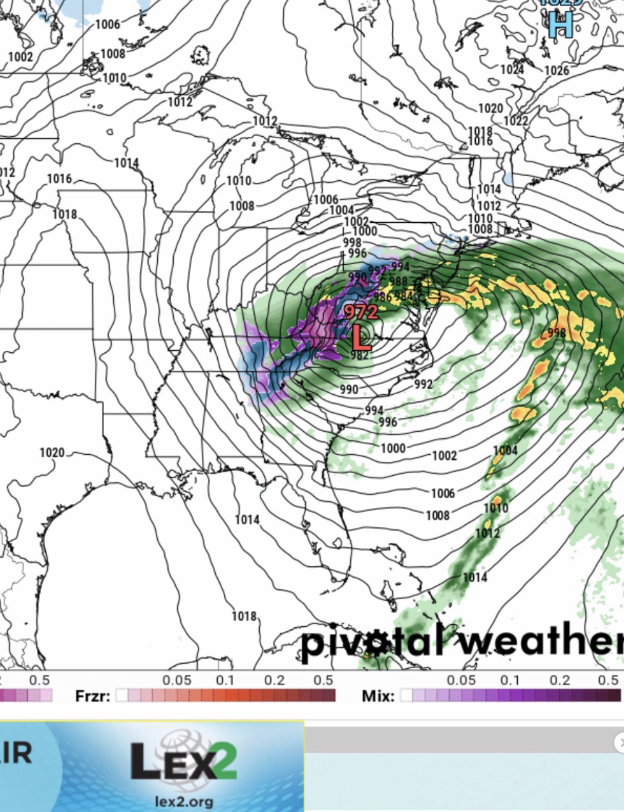
Discussion from GSP .LONG TERM /WEDNESDAY NIGHT THROUGH SATURDAY/... As of 315 am Sunday: The medium range will begin with chilly/drying high pressure building south through the forecast in the wake of the increasingly E/W oriented frontal zone. Global guidance suggests we are by no means out of the woods regarding the potential for resurgent moisture into the cool air mass in the Wed night/Thu time frame, as the 00Z GFS now redevelops precip (albeit primarily a very cold rain) across roughly the southern half of the area Thu morning. While the ECMWF remains considerably drier than the GFS, it nevertheless is trending in a wetter direction, with qpf response now depicted into the southern half of the forecast area Thu morning. Needless to say, small pops are retained in the forecast through the day Thursday, with mainly a mountain snow/Piedmont rain forecast, although the chance of wintry weather developing east of the mtns is certainly there if post-frontal precip does indeed develop. The remainder of the medium range looks dry and colder than normal. .
-
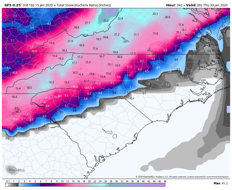
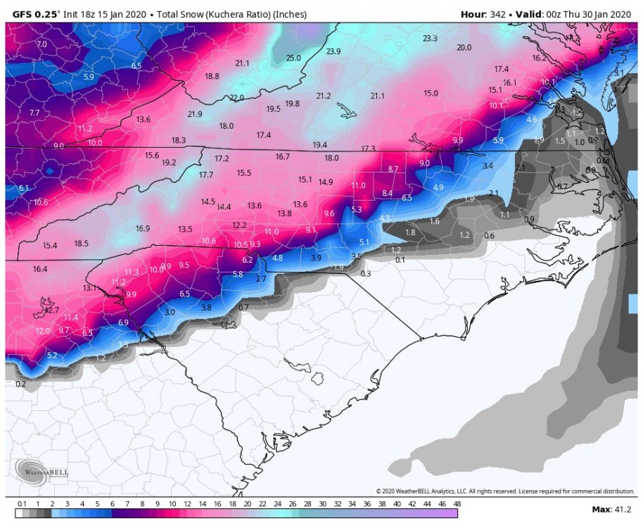
We know the faults of the GFS but it’s shown this storm signal for this date multiple times. Can we finally score? .
-
.


-
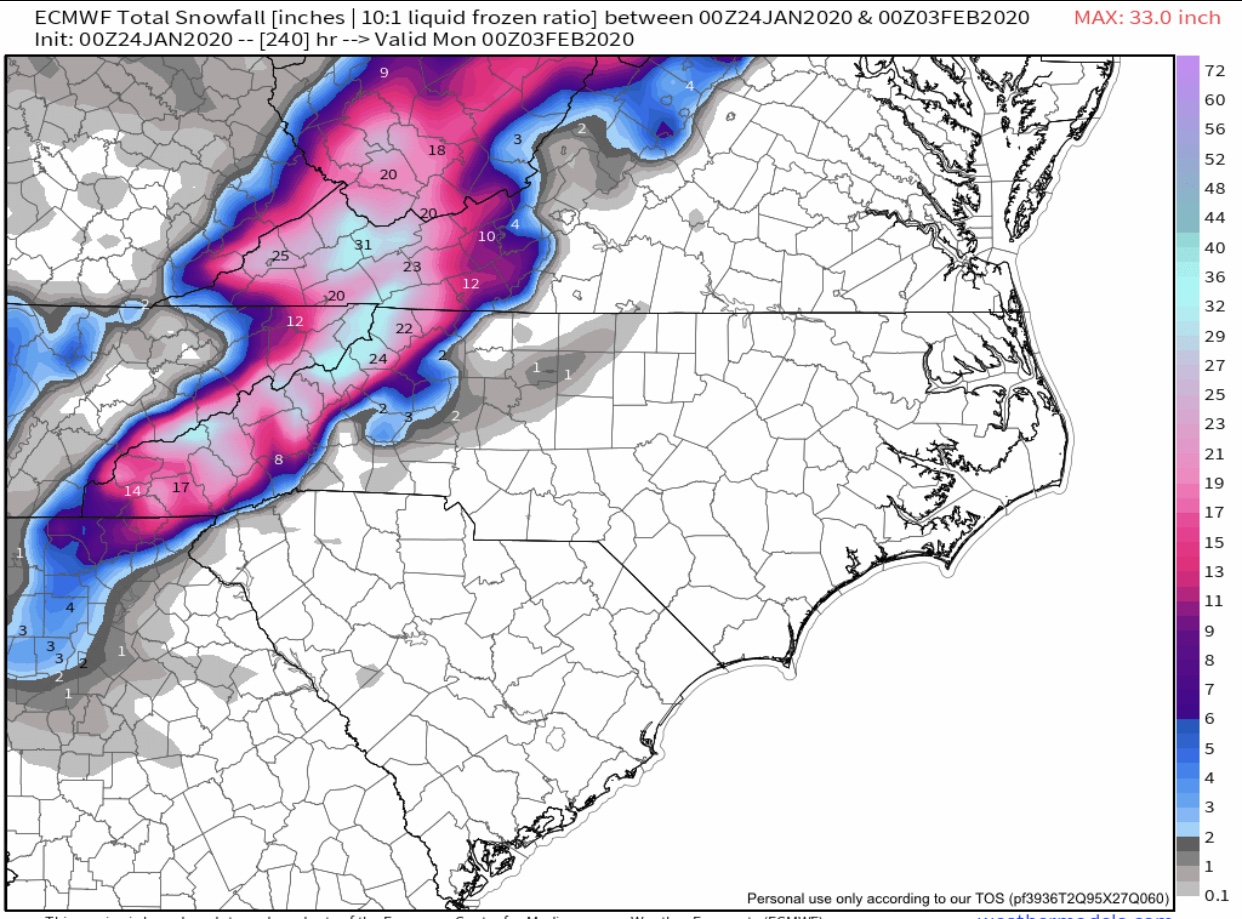
Euro Feb 2 WNC Bomb .
-
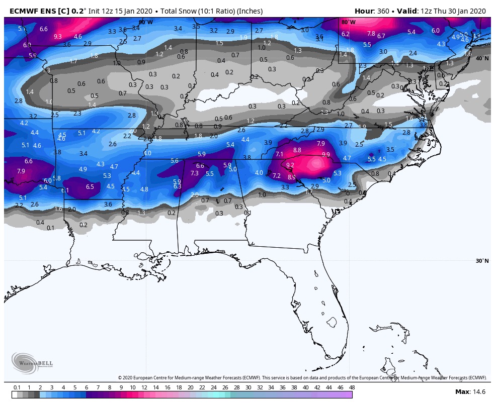
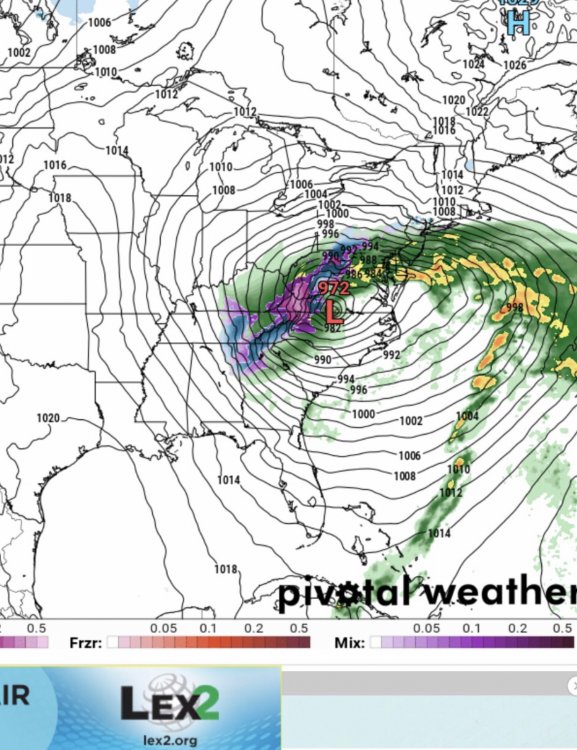
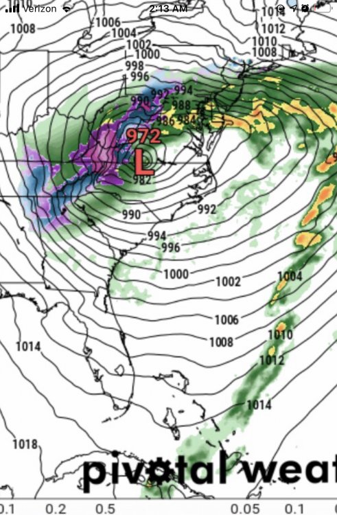
Agree. I just wanted to point out how both the GFS and Euro ENS match closely for 28th/29th storm threat. Yes, over 300 hours so it’s just eye candy. .
-
.

-

December 8-10, 2018 Winter Storm
UpstateSCGamecock replied to Orangeburgwx's topic in Southeastern States
It’s snowing in Clinton, SC. Thanks ULL. . -
December 8-10, 2018 Winter Storm
UpstateSCGamecock replied to Orangeburgwx's topic in Southeastern States
Will precip begin before sunrise or is this an afternoon event for the ULL in SC? . -
December 8-10, 2018 Winter Storm
UpstateSCGamecock replied to Orangeburgwx's topic in Southeastern States
While it’s still 33 in Clinton. We did get 1/2 of sleet from the storm. . -
December 8-10, 2018 Winter Storm
UpstateSCGamecock replied to Orangeburgwx's topic in Southeastern States
GSP’s discussion page doesn’t give much hope for snow south of 85 and they are not sure if frozen gets to advisory criteria. Your post gives me hope. Thanks for the informative posts for your neck of the words. That would bode well for me in S of 85 in SC. . -
December 8-10, 2018 Winter Storm
UpstateSCGamecock replied to Orangeburgwx's topic in Southeastern States
Any one care to discuss the cold air and dew points aligning up with reality as compared to modeling? Are we still on track? . -
December 8-10, 2018 Winter Storm
UpstateSCGamecock replied to Orangeburgwx's topic in Southeastern States
Upstate SC followers hope it’s correct. . -
December 8-10, 2018 Winter Storm
UpstateSCGamecock replied to Orangeburgwx's topic in Southeastern States
. -
Southeast Sanitarium - A Place to Vent
UpstateSCGamecock replied to Jonathan's topic in Southeastern States
He is living in TN. Still follow him on FB. .