

dendrite
-
Posts
63,340 -
Joined
Content Type
Profiles
Blogs
Forums
American Weather
Media Demo
Store
Gallery
Posts posted by dendrite
-
-
End of the month warmup will probably wash these negative anomalies right out.
-
 2
2
-
-
Sun is blazing. Should be a decent midday.
-
1
-
-
Steve what location is that?
-
Just now, Ginx snewx said:
2nd to 2016 here.
I guess…just going by that regional wide map posted. The point is we got the first half of April during the first half of March.
-
9 hours ago, WinterWolf said:
But All we hear is Morch 12 though?
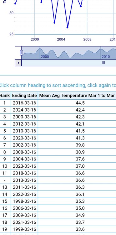
We just had the warmest March 1-16 ever. But yeah, the 2nd half will be cooler especially compared to average.
-
Toss those TT clown maps high and far.
-
2
-
-
48 minutes ago, Ginx snewx said:
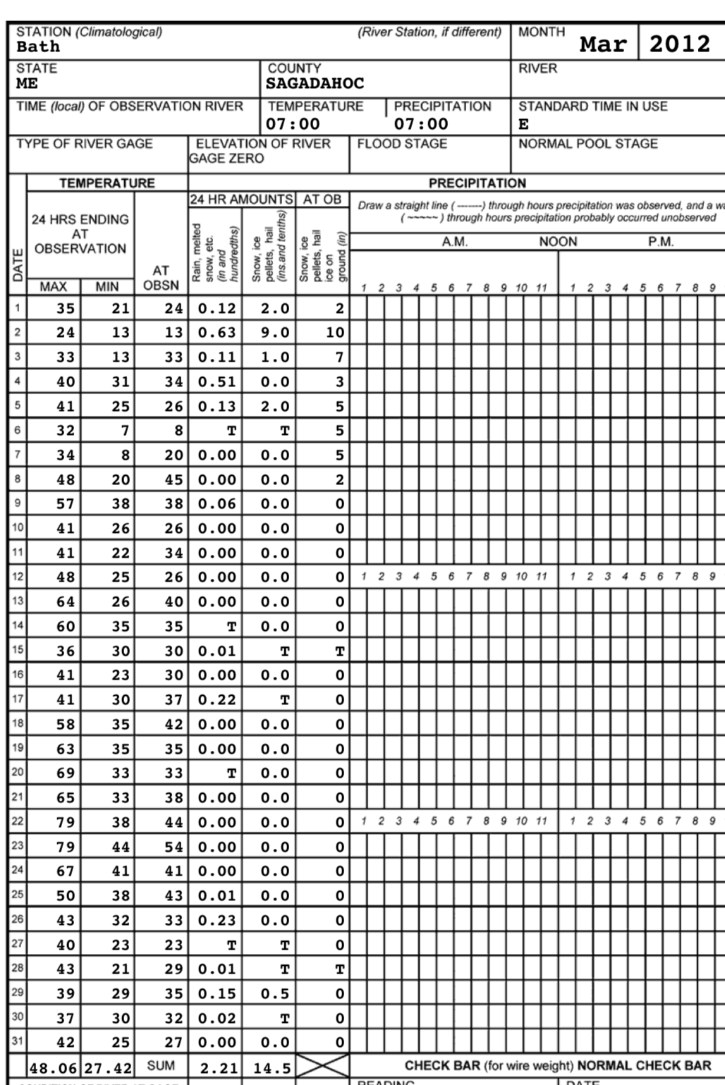
Bath Maine 89 officially but as I said it was above 90 at many home T stats
COOP never hit 80°

-
 1
1
-
-
I have tiger lilies and comfrey coming up.
-
 1
1
-
-
4 minutes ago, tamarack said:
90 on the 25th??? I checked CLIMOD and the max that day was the 3rd consecutive 49.
Instrumentation or coding error. They were having issues that day.
-
 1
1
-
-
20 minutes ago, CoastalWx said:
Let’s hope the gfs is wrong with 5-10” of precip by the end of the run.
3-5” sounds about right. Gotta keep those puddles up. We’ll get 3 dry days in a row in mid April and Epstein will start stressing about the potted plants.
-
2
-
1
-
-
Thick fog this morning…min 29.5°. Up and down over the next week. Hopefully that Friday cold shot moderates some.
-
1
-
-
28 minutes ago, Damage In Tolland said:

-
1
-
 1
1
-
-
2 hours ago, powderfreak said:
It was a cold day. 41/34 is the spread since last night at midnight at the local ASOS.
Normal is 38/16.
+11.5 halfway through March is absolutely insane. Has to be rivaling the top first half of March departures on record.
Coldest +10 day ever
-
2
-
-
5 minutes ago, WinterWolf said:
Lol oh ok…it seems like they intentionally try to make it so dam confusing..like some type of special and secret code.
Get studying. The exam is next week.
https://www.icams-portal.gov/resources/ofcm/fmh/FMH1/fmh1_2019.pdf
-
3
-
-
5 minutes ago, WinterWolf said:
So 0/6/12/18z would be: 0” per hr, 6” for the storm so far, 12” for depth, at 18z?
No I mean that’s when they report the depth if they report it at all. 00z/06z/12z/18z. If it’s once per day it’s usually 12z.
-
1
-
-
1 minute ago, Ginx snewx said:
Airport Asos sites don't do depth anymore
They do if they have a manned observer augmenting the obs
-
1
-
-
You’ll sometimes just see snow depth in a METAR as well. Usually 0/6/12/18z.
4/ddd
Where ddd is the depth in inches. So 24” would be 4/024.
-
47 minutes ago, WinterWolf said:
So does snoincr stand for Snow increasing? Or snow increments? What do we see these days now if they don’t use the three number on the obs anymore?
Snow increasing rapidly
Now you see something like SNINCR 2/24
2”/hr and 24” depth
-
1
-
-
7 minutes ago, CoastalWx said:
Yeah 10” For the storm I believe at the ob time, but it pretty much fell in 6 hrs lol.
Yeah I didn’t think it was 6hr since it was a 23z ob anyway. I think snoincr now is just the hourly rate if >= 1”/hr and then the pack depth.
-
1
-
-
14 minutes ago, WinterWolf said:
Those confuse me some. There’s things in there that I don’t understand. 3/10/11? SLP875-Surface Low Pressure? 875? Can’t be 875 mb…
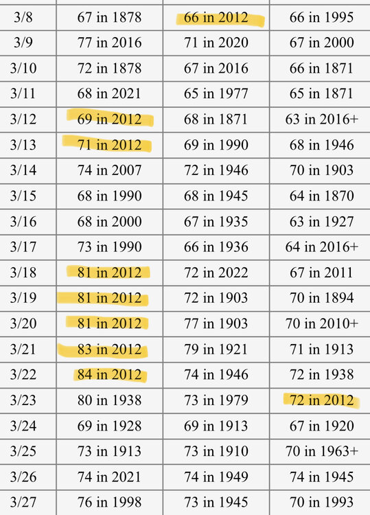
SNOINCR 3/10/11 is 3” in the last hour and then I forget if the coding back then was 10” in the past 6hrs or 10” for the storm. And then I think the 11” is the current depth.
SLP is in every ob in tenths of a mb. So SLP875 is 987.5mb. I think anything coded as 500+ gets a 9 in front of it (low pressure) and anything sub 500 gets a 10 (high pressure).
-
3
-
2
-
-
No gust data, but the Nov 50 sustained winds are always fun to look at.
METAR KBOS 260000Z 09048KT 4SM -SHRA DZ 11/08 A//// RMK SLP089 T01060083
METAR KBOS 260100Z 09040KT 4SM -SHRA DZ CLR 11/09 A//// RMK SLP080 T01060089
METAR KBOS 260200Z 11049KT 3SM -SHRA CLR 11/09 A//// RMK SLP060 P0002 T01110094
METAR KBOS 260300Z 11043KT 11/2SM SHRA 11/10 A//// RMK SLP052 P0005 T01110100
METAR KBOS 260400Z 11047KT 11/2SM SHRA CLR 11/10 A//// RMK SLP033 P0006 T01110100
METAR KBOS 260500Z 11052KT 11/2SM SHRA CLR 12/10 A//// RMK SLP006 P0004 T01170100
-
2
-
-
3 hours ago, CoastalWx said:
Greatest Logan ob ever.
Tough to ever top that.
METAR KBOS 132300Z 06047G62KT 0SM +TSSN -BLSN OVC/// M01/M01 A2916 RMK R04RVR06-V06 TB50 SW MOVG N OCNL LTGIC DRFTG SNW PK WND 0670/33 PRESFR SNOINCR 3/10/11 SLP875 P0028 T10061006
-
5
-
 1
1
-
-
On a somewhat related note…
The weather was a little more wintry on this day 31 years ago.
-
6
-
-
6 minutes ago, wx2fish said:
Atleast locally to me (MHT) we actually started March 2012 chilly and had a snow event leading into the 1st. It was the middle of the month that went wild into the 70/80s. This one has been more consistently mild with less high end stuff. Pretty sure MHT was around +8.5 in 2012, and around +8 mtd this year. We'll see how the back half ends up but with climo warming we will definitely need some 70s to keep pace.
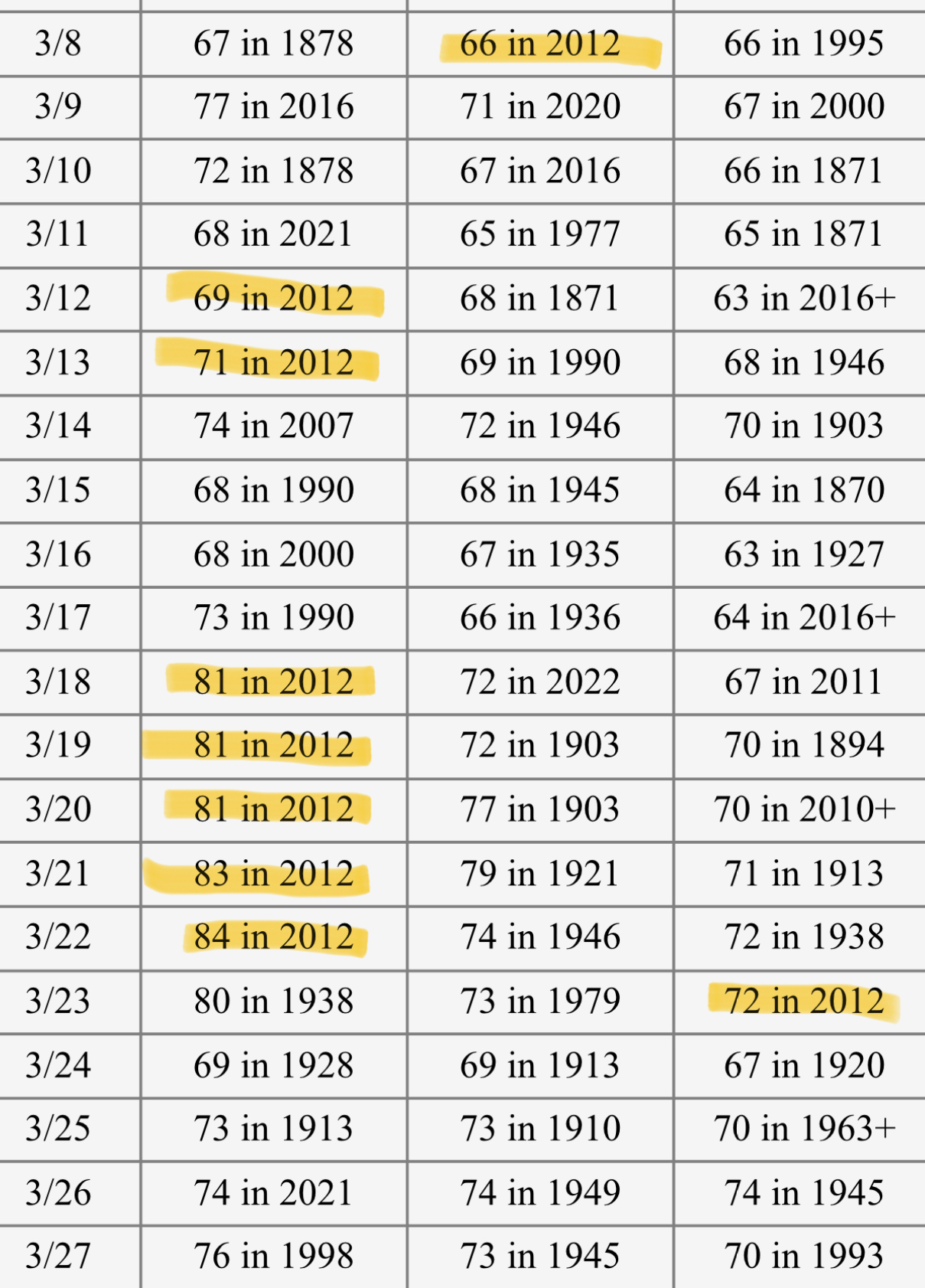
There was a a pretty good warm up a week before it as well. These are CON’s records.
-
1
-
1
-
14th Lawn and Garden Thread P Allen Smith 2024
in New England
Posted
38° here…way too early for that nonsense. My pawpaws start waking at 55-60°. I don’t need that.