dendrite
-
Posts
74,748 -
Joined
Content Type
Profiles
Blogs
Forums
American Weather
Media Demo
Store
Gallery
Everything posted by dendrite
-

November 2025 general discussions and probable topic derailings ...
dendrite replied to Typhoon Tip's topic in New England
It either did or it didn’t. We just don’t know until we look. -
November 2025 general discussions and probable topic derailings ...
dendrite replied to Typhoon Tip's topic in New England
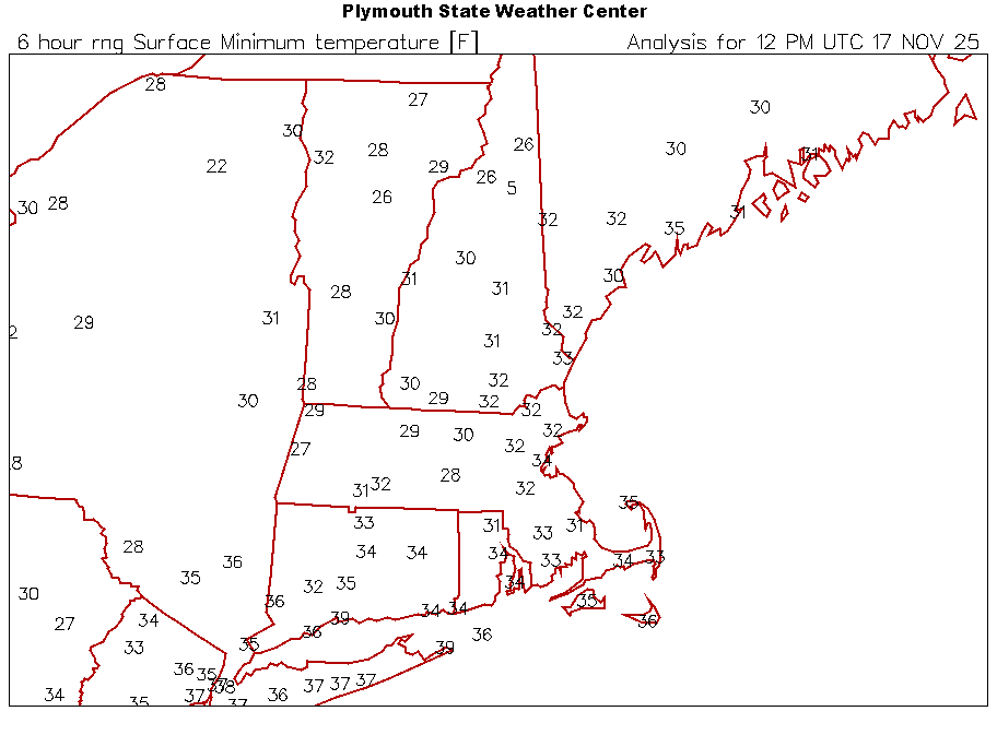
Still dropping. 20.9° -
November 2025 general discussions and probable topic derailings ...
dendrite replied to Typhoon Tip's topic in New England
Well we got below 26°… 22.9° -
November 2025 general discussions and probable topic derailings ...
dendrite replied to Typhoon Tip's topic in New England
I didn’t mean a cold SWFE. But when we’re hanging on to the wedge here near freezing you often mix out in the SE downslope up there. Remember, the primary goes to our west in these and we don’t always get redevelopers south of us. -
November 2025 general discussions and probable topic derailings ...
dendrite replied to Typhoon Tip's topic in New England
One good SWFE and it’ll be 45° at HIE with 40mph SE winds. -
November 2025 general discussions and probable topic derailings ...
dendrite replied to Typhoon Tip's topic in New England
Reinstall in Tol? -
November 2025 general discussions and probable topic derailings ...
dendrite replied to Typhoon Tip's topic in New England
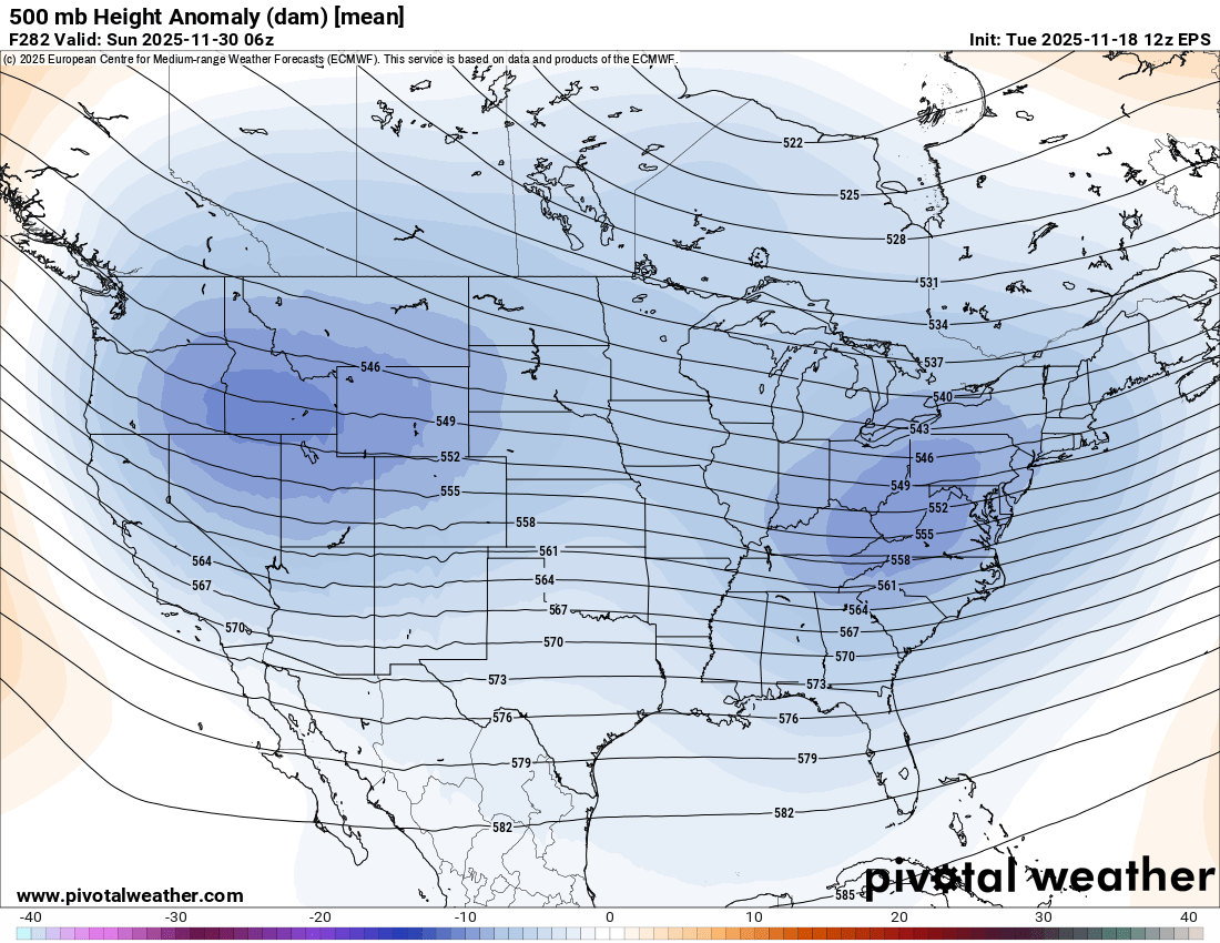
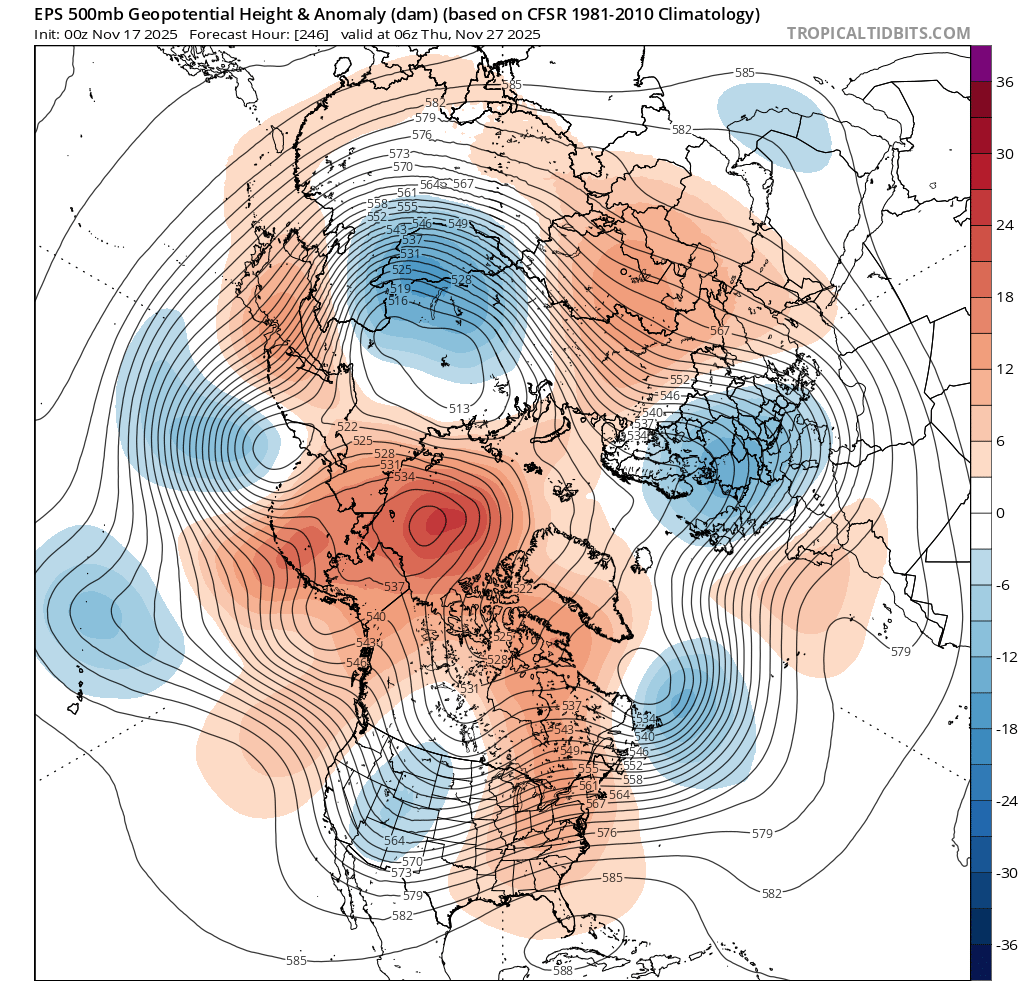
Can we actually get BN heights across the entire CONUS anymore?
-
November 2025 general discussions and probable topic derailings ...
dendrite replied to Typhoon Tip's topic in New England
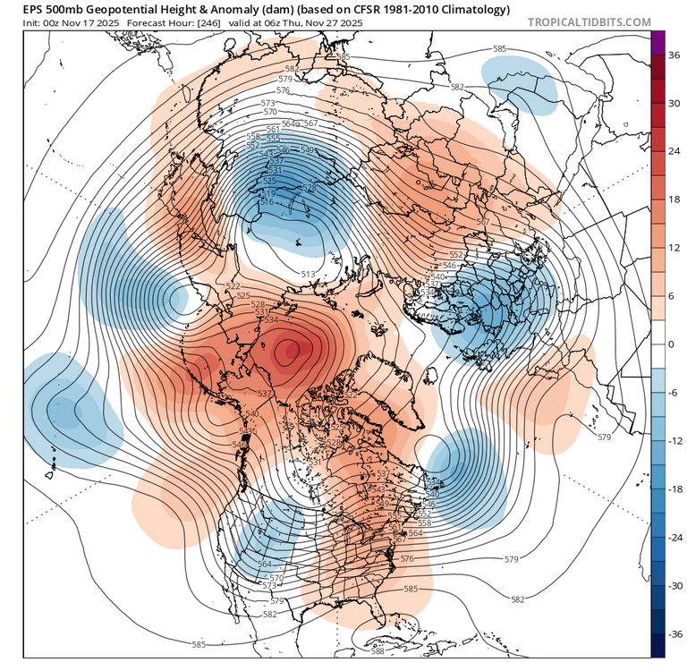
Kidding aside… The op/ens are pretty much what we’ve been saying still. The cold dumps to our west and we eventually get the moderated airmass. Maybe it gets a little wedgy in the region (more favored up here) when the ridging builds in here, but it’s probably a continued swing of AN and slightly BN. -
November 2025 general discussions and probable topic derailings ...
dendrite replied to Typhoon Tip's topic in New England
Check out those dews in CT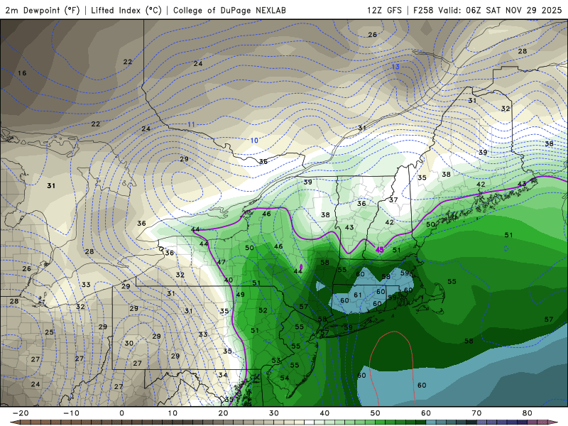
-
November 2025 general discussions and probable topic derailings ...
dendrite replied to Typhoon Tip's topic in New England
I’m trying to think back to the last time we had a cloudflare outage and how the following winter ended up. There’s still time for Ray to make some minor adjustments. -
November 2025 general discussions and probable topic derailings ...
dendrite replied to Typhoon Tip's topic in New England
Did you like them? -
November 2025 general discussions and probable topic derailings ...
dendrite replied to Typhoon Tip's topic in New England
Most dramatic cloud action of the winter? -
November 2025 general discussions and probable topic derailings ...
dendrite replied to Typhoon Tip's topic in New England
It’s 11/18. Who cares if the cold dumps mostly out west for a week or two toward Dec? Pack usually starts settling in here 12/10-15 so it’s nbd to me until then. Anything between now and then typically melts away at some point anyway. -
November 2025 general discussions and probable topic derailings ...
dendrite replied to Typhoon Tip's topic in New England
“Wow…the 71st straight day of snow. Woke up to 4” this morning. Didn’t expect it” -
November 2025 general discussions and probable topic derailings ...
dendrite replied to Typhoon Tip's topic in New England
A puff of southerly wind there and he’s dripping while Ryan is iced up. -
November 2025 general discussions and probable topic derailings ...
dendrite replied to Typhoon Tip's topic in New England
Freak never does. He just humble brags. -
November 2025 general discussions and probable topic derailings ...
dendrite replied to Typhoon Tip's topic in New England
Ginxy AI Will post -
November 2025 general discussions and probable topic derailings ...
dendrite replied to Typhoon Tip's topic in New England
Can’t divide by zero -
November 2025 general discussions and probable topic derailings ...
dendrite replied to Typhoon Tip's topic in New England
-
November 2025 general discussions and probable topic derailings ...
dendrite replied to Typhoon Tip's topic in New England
At least we can make AI maps this winter that show heavy snow inside of day 7. -
November 2025 general discussions and probable topic derailings ...
dendrite replied to Typhoon Tip's topic in New England
Steve is dangerous now. I wish we could go back to the days when he had shitty phone pics -
November 2025 general discussions and probable topic derailings ...
dendrite replied to Typhoon Tip's topic in New England
lolol -
November 2025 general discussions and probable topic derailings ...
dendrite replied to Typhoon Tip's topic in New England
Oh man Steve found the AI. Maybe he can make a vid of a snowstorm in Weymouth again. Although it may get confused and give Scoot 5 legs. -
November 2025 general discussions and probable topic derailings ...
dendrite replied to Typhoon Tip's topic in New England
And yeah, just chop off 2-3° from HVN at all times. Current and mins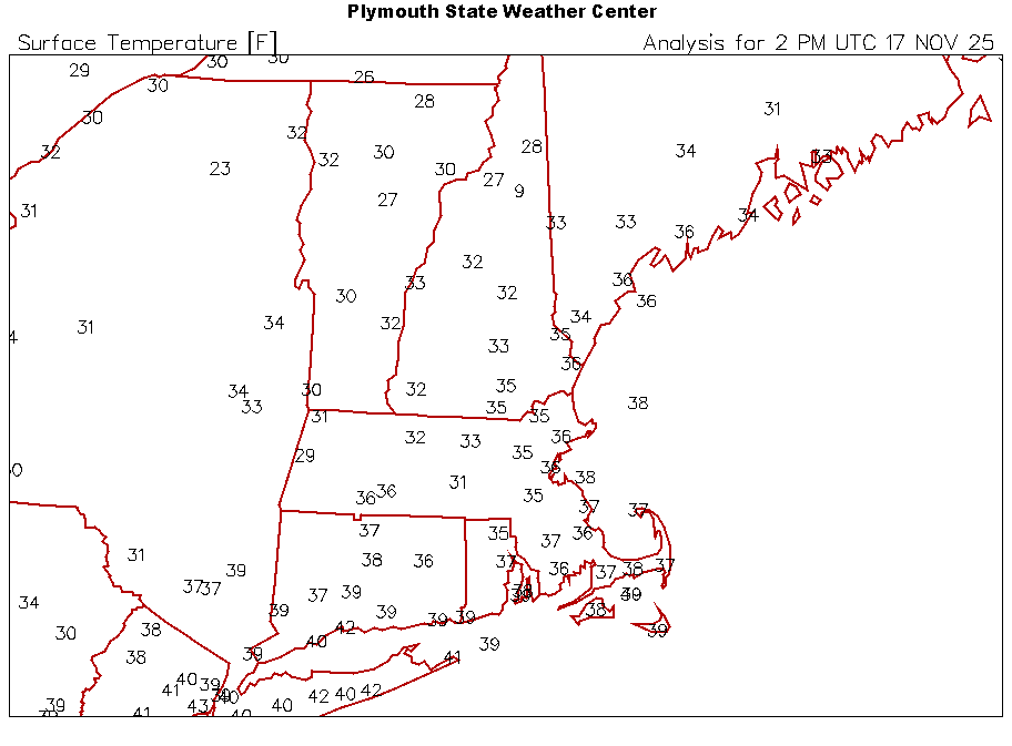
-
November 2025 general discussions and probable topic derailings ...
dendrite replied to Typhoon Tip's topic in New England
Spitting flakes all morning. Days and days. Didn’t expect 28° with wind this morning….shouldve brought the plants that didn’t harden off yet in. Oops.