SACRUS
-
Posts
15,458 -
Joined
-
Last visited
Content Type
Profiles
Blogs
Forums
American Weather
Media Demo
Store
Gallery
Everything posted by SACRUS
-
Extreme Cold, Snow & Sleet: SECS 1/24 - 1/26
SACRUS replied to TriPol's topic in New York City Metro
-
Extreme Cold, Snow & Sleet: SECS 1/24 - 1/26
SACRUS replied to TriPol's topic in New York City Metro
-
Extreme Cold, Snow & Sleet: SECS 1/24 - 1/26
SACRUS replied to TriPol's topic in New York City Metro
1/23 00z RGEM -
Extreme Cold, Snow & Sleet: SECS 1/24 - 1/26
SACRUS replied to TriPol's topic in New York City Metro
00z Total QPF / Snow / Sleet NYC SREF: 1.3 / (8.4) NAM: 1.3 / (8.4) RGEM: 1.4 / (8.6) ICON: 1.3 / (7.5) GFS AI AIGFS: 1.1 / ( 10) GFS: 1.4 / (14.8) GGEM: 1.5 / (8.2) UKMET: 0.9 - 11 / (6 - 10) GEFS: 1.4 / (14) -
Extreme Cold, Snow & Sleet: SECS 1/24 - 1/26
SACRUS replied to TriPol's topic in New York City Metro
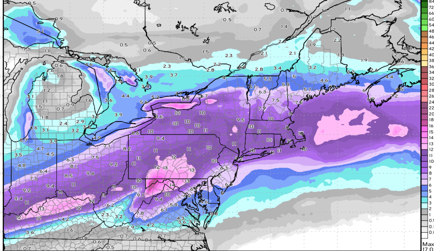
1/23 00z NAM total QPF storm Total snow / sleet (10:1) -
Extreme Cold, Snow & Sleet: SECS 1/24 - 1/26
SACRUS replied to TriPol's topic in New York City Metro
-
Extreme Cold, Snow & Sleet: SECS 1/24 - 1/26
SACRUS replied to TriPol's topic in New York City Metro
-
Extreme Cold, Snow & Sleet: SECS 1/24 - 1/26
SACRUS replied to TriPol's topic in New York City Metro
-
Extreme Cold, Snow & Sleet: SECS 1/24 - 1/26
SACRUS replied to TriPol's topic in New York City Metro
-
Extreme Cold, Snow & Sleet: SECS 1/24 - 1/26
SACRUS replied to TriPol's topic in New York City Metro
-
Extreme Cold, Snow & Sleet: SECS 1/24 - 1/26
SACRUS replied to TriPol's topic in New York City Metro
1/23 00Z NAMD is updating -
Extreme Cold, Snow & Sleet: SECS 1/24 - 1/26
SACRUS replied to TriPol's topic in New York City Metro
-
Extreme Cold, Snow & Sleet: SECS 1/24 - 1/26
SACRUS replied to TriPol's topic in New York City Metro
1/23 21Z SREF Total QPF (87H) mean Total snow / sleet mean (10:1) -
Extreme Cold, Snow & Sleet: SECS 1/24 - 1/26
SACRUS replied to TriPol's topic in New York City Metro
1/22 18z Euro Total QPF storm NYC : 1,2 Total snow / sleet (10:1) 9.2
-
Extreme Cold, Snow & Sleet: SECS 1/24 - 1/26
SACRUS replied to TriPol's topic in New York City Metro
Updated -
Extreme Cold, Snow & Sleet: SECS 1/24 - 1/26
SACRUS replied to TriPol's topic in New York City Metro
1/22 18z Euro AI AIFS total QPF storm Total Snow / Sleet (10:1) -
Extreme Cold, Snow & Sleet: SECS 1/24 - 1/26
SACRUS replied to TriPol's topic in New York City Metro
1/22 18z GEFS total mean QPF storm Total snow / sleet mean (10:1) Lean LP -
Extreme Cold, Snow & Sleet: SECS 1/24 - 1/26
SACRUS replied to TriPol's topic in New York City Metro
Updated -
Extreme Cold, Snow & Sleet: SECS 1/24 - 1/26
SACRUS replied to TriPol's topic in New York City Metro
Back up with the 1.25 line -
Extreme Cold, Snow & Sleet: SECS 1/24 - 1/26
SACRUS replied to TriPol's topic in New York City Metro
Wed morning -
Extreme Cold, Snow & Sleet: SECS 1/24 - 1/26
SACRUS replied to TriPol's topic in New York City Metro
Tue night ice box -
Extreme Cold, Snow & Sleet: SECS 1/24 - 1/26
SACRUS replied to TriPol's topic in New York City Metro
1/22 18z GFS AI AIGFS Total QPF storm -
Extreme Cold, Snow & Sleet: SECS 1/24 - 1/26
SACRUS replied to TriPol's topic in New York City Metro
1/22 18z GFS total QPF storm 18z Total Snow / Sleet (10:1) -
Extreme Cold, Snow & Sleet: SECS 1/24 - 1/26
SACRUS replied to TriPol's topic in New York City Metro
-
Extreme Cold, Snow & Sleet: SECS 1/24 - 1/26
SACRUS replied to TriPol's topic in New York City Metro