

Caveman
-
Posts
167 -
Joined
-
Last visited
Content Type
Profiles
Blogs
Forums
American Weather
Media Demo
Store
Gallery
Posts posted by Caveman
-
-
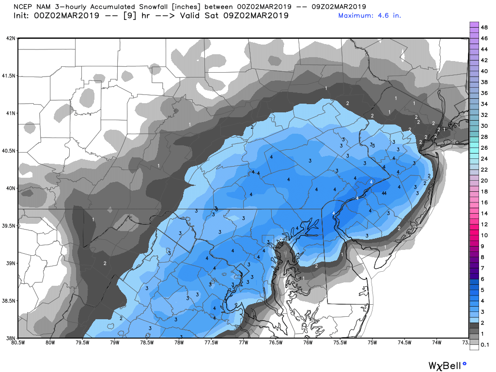
Central PA...NYC is spit away and here is the screenshot from the model output...

-
6 minutes ago, paweather said:
what NAM are looking at? and what sub forum are you in?
-
Looks like the NAM told DeBlasio the atmosphere will not cooperate with his charge to re-open NYC this week!
-
 1
1
-
-
Just now, canderson said:
Lower. The coastal could form too east, too late, too north, etc. they didn’t say to expect it, but it’s a possibility. We know this with Miller Bs.
The "B" in Miller B represents "bitch" of a prognostication...
-
Just now, Mshaffer526 said:
00Z HRRR Is pretty disappointing for a lot of areas. Obligatory "outside its range" but surprising.
Way too far in time and space...HRRR is excellent with convection within 6 hours of initialization...not with synoptic physics of the atmosphere...IMHO
-
 1
1
-
-
1 hour ago, Jim Marusak said:
Upstream river forecast crest numbers are getting a bit scary.
- Sunbury - mod flood - 27 ft
- Danville - mod flood - 26.6 ft
- Bloomsburg - mod - 26.4 ft
- Wilkes Barre Courthouse - major - 33.7 ft
- Meshoppen - moderate - 36.4 ft
- Towanda - Moderate/Major 24ft
- Waverly - major - 20ft
these types of numbers are looking an awful lot like January 1996 style numbers. And NWS-Binghamton is hinting there may be some chunks of ice in the Susquehanna as well, which may make things worse if they jam under a bridge. Let's hope this isn't the case on Christmas day.
I was just up to Towanda yesterday and there was very little to no ice in the river. Ice dams should not be a concern. Obviously they do have quite a snowpack up in that region however which is not good with these high dew points and mild temps!
-
Etters, PA (northern York County)...9" total with a liquid equivalent of 0.98". Had light sleet and very light snow for several hour period from about 6-10 pm or so. Just not nearly as much precip fell as was being modeled by numerical guidance. This storm very much underperformed for northern York County. To be sure it was a good snow event and it's very wintry (and pretty) outside, but it most certainly was not what was being touted in terms of a winter storm of major proportions...Side note; the official observation at KMDT (9.3" as of midnight) for one of the few times had a greater snowfall than I am reporting!
-
The mail is being delivered here in Etters! 4"+ and visibility about 1/8 mile...
-
+SN for last hour, Etters, PA and very wintry. These old bones say "It's cold"!
-
7 minutes ago, NeffsvilleWx said:
I hate NWS radar coverage (or lack thereof) for Lancaster/York. Always impossible to tell whether precip is weakening as it approaches, or if it's just a result of radar range/beam height. And comparing to WGAL's site is difficult -- different scales.
Use Sterling, Dover, SC and then extrapolate...as an "old fart", I think the radar products are simply amazing!
-
32 minutes ago, CarlislePaWx said:
At 1:00pm I have measured 0.7" total over the past 3 hours...lol. Temp 25/22. Steady light snow with fine flakes. Definitely not accumulating quickly.
Looking at the latest HRRR and going through it hour by hour it looks like my area reaches the 1.5" mark within the next 2 hours by 3:00. Then the fun begins with 1.0"/hour or more rates through 9:00pm. The heaviest hour is between 8:00 and 9:00 when 2.4" falls. At the end of the storm at 4:00am I have between 18 and 19". The sleet line just barely makes it up to me around 9:00pm and sticks around for an hour or so, then back to snow.
During the March 1993 event, sleet mixed in during the "height" of the storm with strong NE winds and lightning/thunder at that point. So as per your analysis of the model HRRR, look for sleet and thunder and gusty winds around 8-10 pm ish...the stronger and deeper this low gets, expect sleet well inland and convective properties including charge separation and high rates of precip. It will be interesting to be sure!
-
+SN here in Etters. Began to bring it about 11:30 am EST...
-
1 minute ago, CarlislePaWx said:
3k NAM has 45-50 dbz reflectivity over Cumberland county for 3 hours between 0Z and 3Z! That's like 4"/hr rates. 22" total snow, 26" Kuchera total. WOW
That greater radar reflectivity could indicate sleet mixing in which is the time frame of that most likely occurring...still likely one for the books!
-
Hello all...I was wondering if anyone knows about the MAD WEATHER Teleconnections website? Has it been moved to a different web address or has it been discontinued? It was very helpful and one I often looked to during the cold season. Any insights would be greatly appreciated!
-
1 minute ago, bubbler86 said:
Your original post asked why the radar looked like CARP. LOL. I should not talk I have an issue with Chrome where it keeps turning off my spell check so I have to edit a lot of posts.
Either the models are going to bust or that coastal is going to energize the radar starting in Maryland then heading Northeast over much of the LSV.
Rock and Roll!
-
5 minutes ago, paweather said:
Why does the radar look like carp.
I'm talking Sunday's event...today's radar is a bit of a bottom feeder...
-
1
-
-
1 minute ago, KPITSnow said:
Can someone explain to me, how with no blocking, this Sunday stormis being pushed south? I have seen so many times where there is no blocking and the low tracks up to state college. I’ve also see. So many times that it gets suppressed because of strong blocking high pressure. In this case, there is no blocking, and the storm is consistently being modeled further and further south?
500 mb PV digging strong...
-
1
-
-
7 minutes ago, bubbler86 said:
It is really snowing/frz raining lightly here so I bet he is getting similar. Here is his link
https://www.wrh.noaa.gov/mesowest/getobext.php?sid=E5637
Thanks so much...he's a solid earthling observer!
-
Just now, bubbler86 said:
His weather stations are online. They are reporting 30/28 rright now with .01 of precip in the last hour.
I do not know how to access that data...? Freezing drizzle...0.01"?
-
By the way...where has "Cashman" been...? I would've like to seen his obs from earlier today?
-
Just now, bubbler86 said:
Latest MESO Pressure maps show the low developing off shore east of VA Beach. If there was any kind of blocking this would be a blockbuster event with cold air being dragged into the system while qpf is thrown back over us.

What you describe is exactly what COULD occur Sunday...especially with height falls right over PA digging towards a deepening surface LP...but my concern is no HP north of us in realistic terms. My forecast mantra; predict the high; predict he snow! Isn't this fun? Helluva lot better than Netflix or whatever people do today...I'm listening to kick ass tunes, reading you guys opines, and studying the models...since my dogs are now asleep...GOOD STUFF!
-
1
-
-
In all honesty, I believe the snowfall rates will be hard pressed to reach what we did last night here between 2-3 am....it just flat out dumped snow...awesome! My dogs went out and quickly came back to the house...and they are not snowflakes!
-
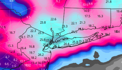
When I saw all of the precip with the Sterling radar, I immediately thought oh no for Sunday...that water vapor energy will translate away from our area.
3 minutes ago, bubbler86 said:It is doing this with forcing from the developing far off shore coastal so yea, we shall see. MA talking about radar back edge but the edge will stop if the NAM depiction is correct....will actual pivot a bit.
Edit, though this map must be including sleet. Cherry Hill NJ is probably not getting 4".
Agree...the equations are simply for frozen precip...go K for rip/read...as for developing LP, seek the temp gradient...that's a shitload of precip across MD...love the meteo!
-
The NAM by 4 am tomorrow...I'm not so sure...

Central PA - Jan 31 to Feb 2 Winter Storm
in Upstate New York/Pennsylvania
Posted
Even if 25% verified, will be some heartache with high water Super Bowl weekend when temps spike with another 1" of precip...