

Caveman
-
Posts
167 -
Joined
-
Last visited
Content Type
Profiles
Blogs
Forums
American Weather
Media Demo
Store
Gallery
Posts posted by Caveman
-
-
11 hours ago, TimB84 said:

Several comments here.
1. it’s 3 days short of a record.
2. this is the first time in recorded history that MDT made it through July and August without dropping below 60.
3. Five of the top ten have been in the last 6 years.
Warm AMO cycle with higher dew points and thus warmer minimums.
-
12 hours ago, Bubbler86 said:
They reshaped the counties.
Drainage basins for the various streams. Hydrology forecasting is very tricky for so many reasons!
-
13 hours ago, Blizzard of 93 said:
@canderson
Who won the contest?I was waaaaay under!
-
8.22" storm total.Valley Green, northern York County.
-
2 minutes ago, losetoa6 said:
Impressive
Local?
Valley Green, northern York County.
-
 1
1
-
-
8 pm: 8.12” oh and still raining!
-
2 minutes ago, Itstrainingtime said:
I received 9.71" on 9/7/2011. If it rained here for 24 hours today, I think we'd definitely rival that.
Here are my obs leading up to Lee...Valley Green
-
1
-
-
Now at 7.18" as of 6:15 pm Valley Green
-
1
-
-
2 minutes ago, Superstorm said:

Think these might be underestimated by radar:
6”….yellow
5”….purple
4”….blue
.I'm in that little yellow square just east of I-83 under the "E" in E-Town.
-
And as of 4 pm here in Newberry Twp, there are 16 roads closed. Many of the closures are within a couple of miles of my location (Valley Green).
-
1 minute ago, canderson said:
MDT is at 5.12” as of 5 pm. Won’t add much more it appears (at least I don’t think it’ll add .5”) so it’ll be the 5th rainiest September day it seems.
I'm 2.25 miles SSW of KMDT and have received 6.89" as of 5:15 pm! I hope you're right about that 1/2 inch prediction!
-
1 minute ago, Mount Joy Snowman said:
Wow! I have buddy who lives up in Etters, you guys are really takin it on the chin up 'er.
Crazy! And you are really just on the other side of the river...
-
5.07" as of 3:25 pm...with winds freshening! Valley Green
-
4.07" now at 2:00 pm; also starting to get a tad breezy.
-
3.76" as of 1:30 pm Valley Green...
-
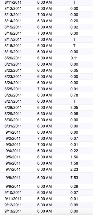
As of noon, 3.05" total here in Valley Green...most of it fell from 9:00 am on. Getting ready to go out and bail again soon! Not looking forward to this afternoon!
-
I just now reached 1.50"; Valley Green, northern York County
-
3 minutes ago, canderson said:
More of you need to enter my contest. I’ll buy the winner a sixer of their favorite beer.
Harrisburg: 3.25"
Lancaster: 2.75"
York: 3.10"
Tamaqua: 4.75"
Williamsport: 1.75"
State College: 2.25"
Chambersburg: 4.00"
Clearfield: 1.50"
Just my random thoughts...
-
1
-
-
Where is a good source to look for synoptic upper air analogs? I like to use CIPS during the winter storms...Thanks!
-
1 hour ago, Voyager said:
Thanks! CTP shows .43" for my area. Hopefully smart minds (boss or receiver) say to park the truck.
Was on I-81 from Wilkes Barre south to I-78 couple of hours ago; light freezing drizzle was icing my truck and windshield, but the roads were still just wet. But the "sun" was still up at that time...I personally would be in park now that the sun has set...
-
0.23" liquid with 2.6" new snow accumulation. It's certainly been a wintry stretch...
-
13.2" total; 8.1" from 7 am Monday with liquid equivalent of 0.61"...Still light snow at 7 am...
-
5.1" new snow; 4.8" on ground at 7:00 am; 0.46" Liquid equivalent...Etters, N York County, PA
-
1 hour ago, medmax said:
Anyone have a 850 pressure map?SPC (Storm Prediction Center) website; mesoanalysis, upper air...
https://www.spc.noaa.gov/exper/mesoanalysis/new/viewsector.php?sector=17#
Central PA - Summer 2021
in Upstate New York/Pennsylvania
Posted
What is that drain?