
Caveman
-
Posts
219 -
Joined
-
Last visited
Content Type
Profiles
Blogs
Forums
American Weather
Media Demo
Store
Gallery
Posts posted by Caveman
-
-
7 hours ago, AccuChris said:
It is not exact, but it has some similarities to the “surprise” January 24-25, 2000 coastal. The H84 NAM 500mb map is closely similar to the 12z Jan 24 2000 500mb re-analysis. That storm dumped heavy snow in the Carolinas and Virginia, Maryland, Delaware and I remember eastern PA got between 8-14”

.
This is from the CIPS website...kinda fun to peruse... https://www.eas.slu.edu/CIPS/ANALOG/analog.php
-
1 minute ago, Festus said:
My snow/sleet ratio is flipping between 20/80 and 80/20 like every 5 minutes. Must be right on the edge.
Same here in Valley Green, northern York County.
-
As of 10 am, had 6.1" with a 0.54" liquid. Still about 0.25 mi visibility.
-
39 minutes ago, CASH_COOP said:
7a obs
light snow
10f
3.3”M
0.29” liquid
Snow began ~3:30 am. 2.9" snow with 0.26 liquid. 11°F with 0.25 mi visibility at time of observation. 11.5 SLR to this point in the event. Valley Green, northern York County.
-
 4
4
-
-
31 minutes ago, Jns2183 said:
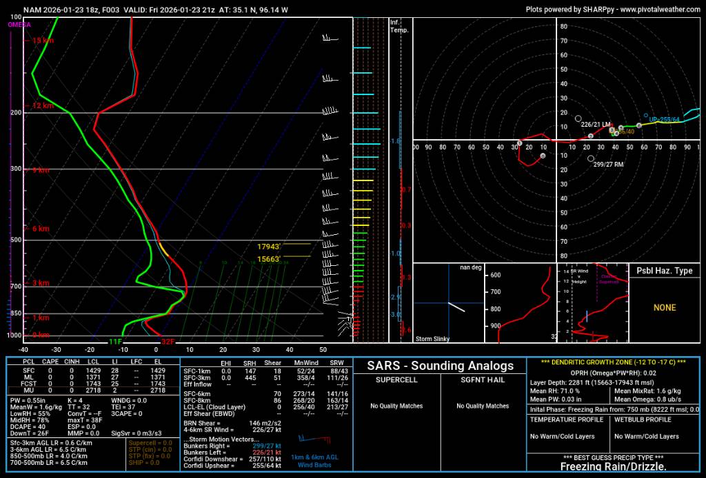
This is the sounding for Norman Ok, off the 18z NAM for 21z, a mere 3 hours after initiation. Next image is temperature from weather ballon launched at 21z.
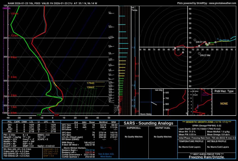
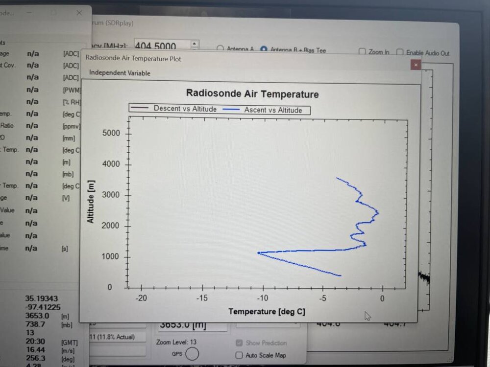
Sent from my SM-S731U using Tapatalk
Thoughts? I have many...
-
15 minutes ago, MAG5035 said:
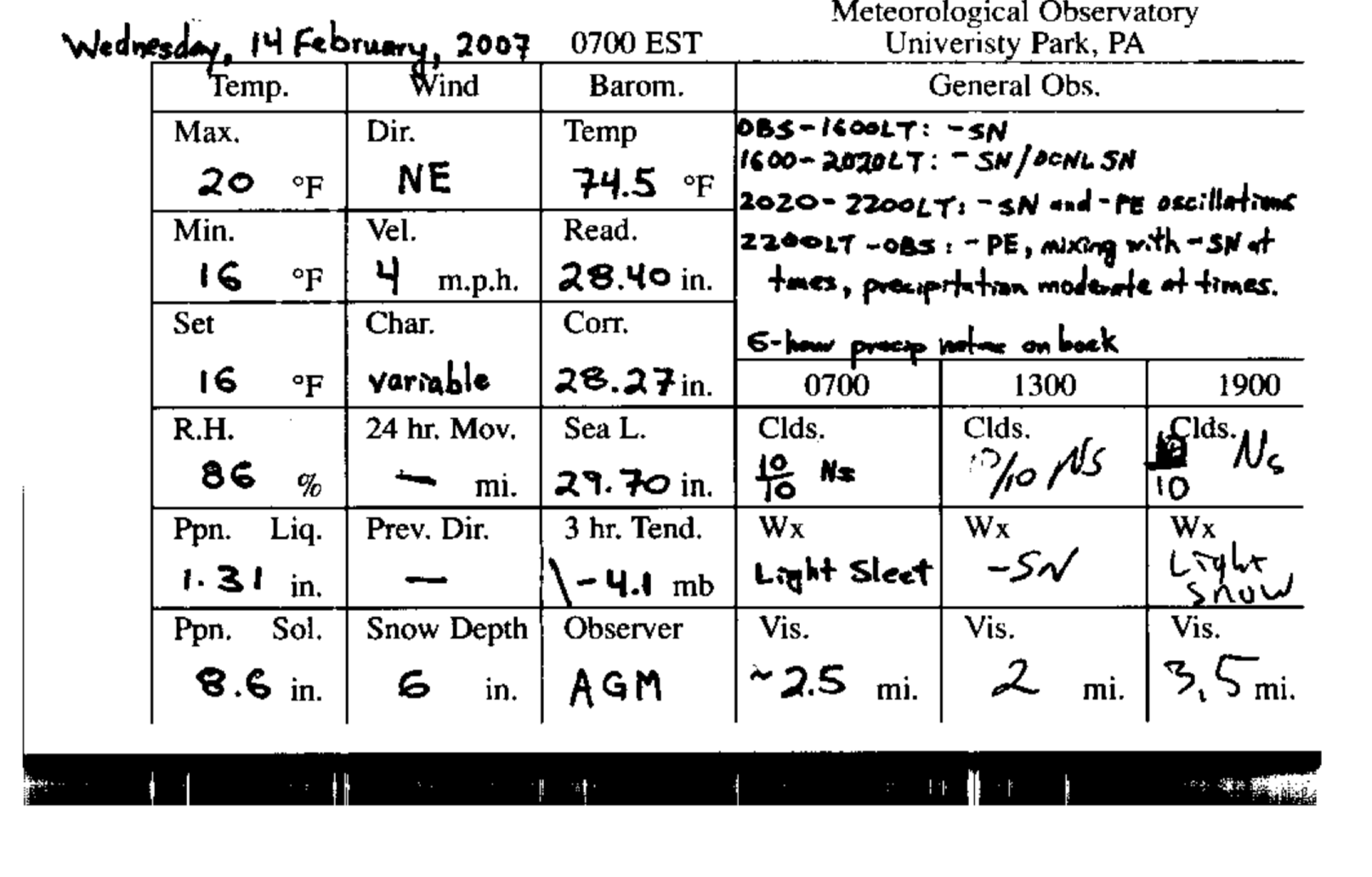
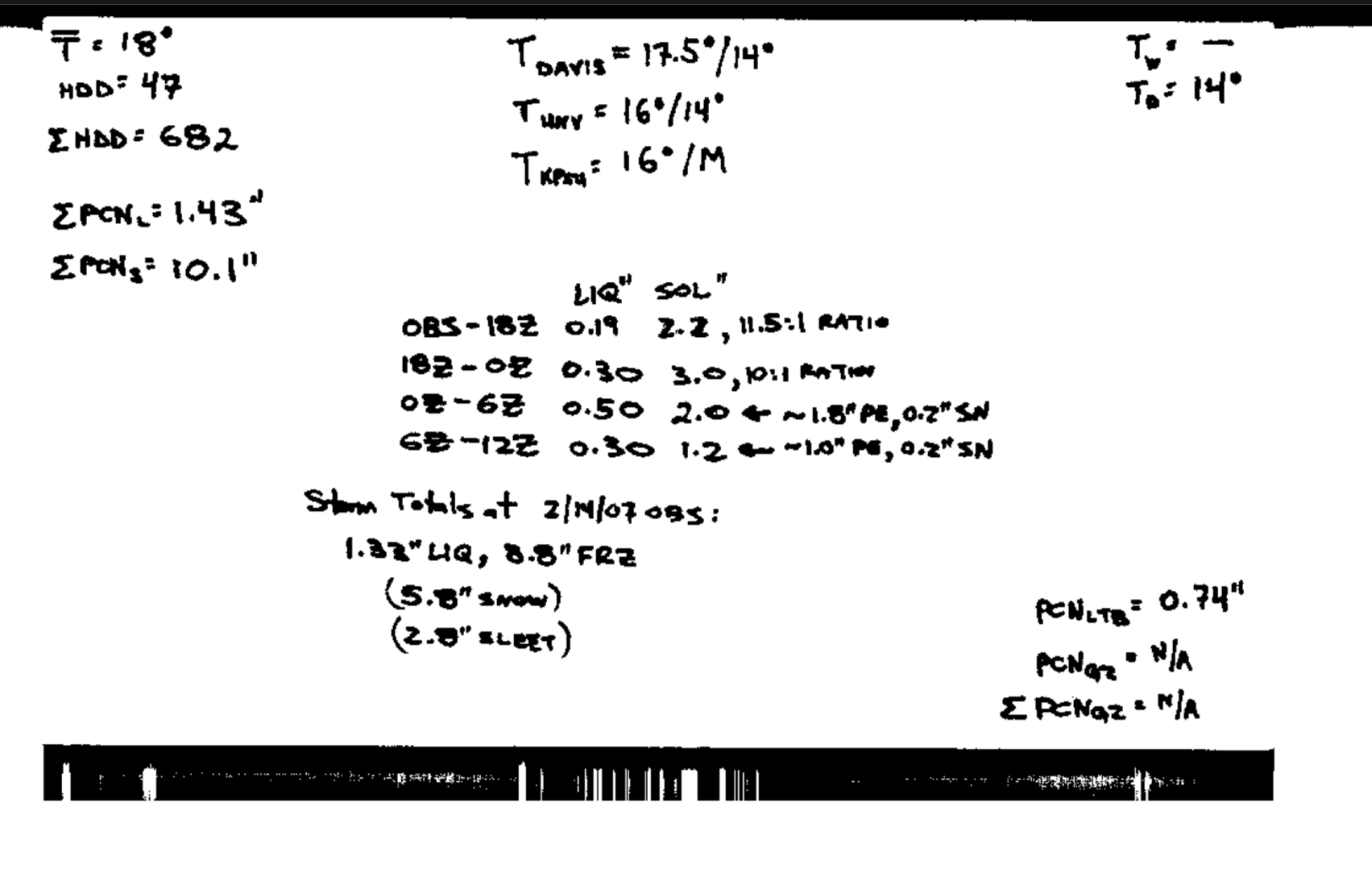
Back this way the PSU Walker Building noted 5.8” of snow and 2.8” of sleet on the observation card from that event, and then a further 1.8” of snow on the next day’s observation card. I do remember this storm made quite the glacier pack.

That was the I-78 Lebanon County fiasco!
-
Everyone here shares a desire to better understand the weather and climate in and around central Pennsylvania. We all have our own biases, but at the core, we want to learn from one another and exchange perspectives on the current state of the atmosphere and the parameters that go into predicting sensible weather.
Few of us are true modelers, yet we all try to interpret the models and, at times, extrapolate beyond them. What binds us together is a genuine love of weather—and, admittedly, the extremes the atmosphere can deliver.
Whether it’s Kyle or Eric is ultimately irrelevant. I was fortunate to be around many “heavy hitters” at PSU in their heyday at Walker, and it all reinforces the same point: we love the weather and strive to better understand the outcomes, whether they turn out to be a boom or a bust.
Over the past several days, many of us have had our emails and messages light up with requests for our thoughts. That’s a compliment to this community and a sign of the respect people have for the collective knowledge here—especially regarding the nuances of our fickle atmosphere in the LSV.
So with that said, whether it’s Eric, Kyle, Ryan, Joe, DT, or Dr. Greg, we’ve all learned from those who have dedicated their lives to understanding sensible weather. Let’s appreciate all of them, appreciate the meteorology of the impending event(s), and remember both the booms and the busts we’ve seen—and will continue to experience in the future.
-
2
-
-
1 hour ago, Yardstickgozinya said:
Well, I'm not trying to be a dick, buddy. but a lot of these guys here aren't going to take kindly to the back and forth between me and you with a event of this nature coming into the short range. I don't know exactly what defines a blizzard but at this point the national weather service is either not seeing or are anticipating we meet the criteria. Furthermore if they are going to put out a blizzard warning, they have to be confident that they know where the criteria will be met. Once that's pinned down., maybe we'll see something like that somewhere. As far as duration no one can give you an accurate answer on that yet with this particular storm.
39 minutes ago, Ruin said:I know for a blizzard criteria temps in the teens and winds higher then 20 mph mostly it doesnt depend on heavy snow but high winds and temps in the teens. atm my high is now only 15 this would bring me to 20-1 ratio which during yesterday was said to be a stretch we would be in the mid teens during the snow they were looking at temps 18-20 yesterday but ty for the reply
From the National Weather Service...
Blizzard Warning
A Blizzard Warning means that the following conditions are occurring or expected within the next 12 to 18 hours.
1) Snow and/or blowing snow reducing visibility to 1/4 mile or less for 3 hours or longer
AND
2) Sustained winds of 35 mph or greater or frequent gusts to 35 mph or greater.
There is no temperature requirement that must be met to achieve blizzard conditions.-
 1
1
-
-
1 minute ago, GrandmasterB said:
With some new folks finding this forum you should put a 288 hour disclaimer somewhere.
Read the timestamps...kinda simple...
-
16 minutes ago, Jns2183 said:
I guess it's due partly to the strength of the new low forming offshore and the timing of the phase but in a couple images I can show you whats stopping this from being a top 5 storm most likely. That dry air pours in during handoff shutting our preceiptitation off early Monday. The coastal doesn't really get going or does far too late due to the progressive nature and timing. I think some of the bigger totals like 24" plus were due to everything happening earlier and the phase being stronger allowing coastal to spin up. Yes we would definitely still dry slot some, and sleet might be an issue for a bit but the ccb makes those minor incidents for those lucky enough to be under it, although I'd wager at least 5 pages of doom posting during lull from those who a few hours later would be posting in ecstasy
Sent from my SM-S731U using Tapatalk
That last sentence is truthful and hilarious...!
-
17 minutes ago, Jns2183 said:
Here's substack post from new app
https://open.substack.com/pub/actuallyweather/p/which-forecast-is-best?utm_source=share&utm_medium=android&r=16mod
Sent from my SM-S731U using Tapatalk
Interesting...even from a slide rule old fart!
-
8 minutes ago, Jns2183 said:
Here's from an infograph I made from the text bulletins of the 19z NBM. specifically regarding snowfall percentile amounts by region
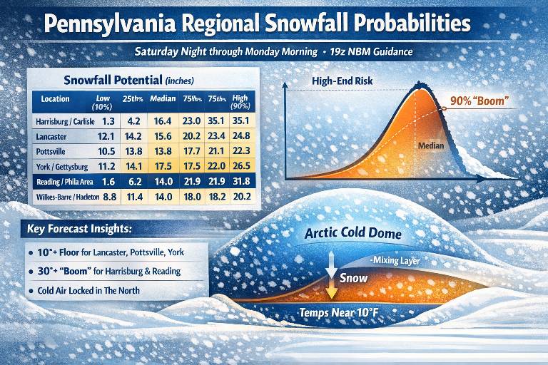
Sent from my SM-S731U using Tapatalk
That’s very cool! The communication of the numerical guidance in one succinct graphic! Awesome!
-
1 hour ago, paweather said:
We had the same in the 1993 super storm where sleet fell but it didn’t hurt amounts plus a good front end thump before any changeover would occur.
Remember it well…sleet and heavy snow complete with lightning and thunder in the midday of the height of the 1993 March nor’easter!
-
1
-
-
Nearly identical observations for the Saturday and Sunday light snow events from Valley Green, northern York County:
Saturday: 1.5" of snow with a liquid eq. of 0.08"
Sunday: 1.4" of snow with a liquid eq. of 0.07"
Snow on snow is always kinda nice; NFL officials playing such a huge role in any and all games, well, not so much!
-
 1
1
-
-
1 hour ago, Itstrainingtime said:
Loved Penn State's effort today. Satisfying way to end a crazy season. It'll be interesting to see what Ethan decides to do. I'm a fan.
If he was truly being advised to better his chances in the NFL, he should stay on at PSU (as a backup), learn under the new HC and OC and their 5th year QB, then play one or two years at PSU and take it from there...
-
1
-
-
0.29" liquid and 0.25" ice accretion. Roads might be fine (not so much here off the beaten path), but the driveway is solid ice and as the melting commences, that liquid is an excellent lubricant. Pretty bad ice storm for these parts in my opinion!
-
1
-
-
The cold definitely held serve with this "occluded confusion"...my drive from KMDT to Newberrytown was a real treat; 65 minutes vs a "normal" 25 minutes...
-
 1
1
-
-
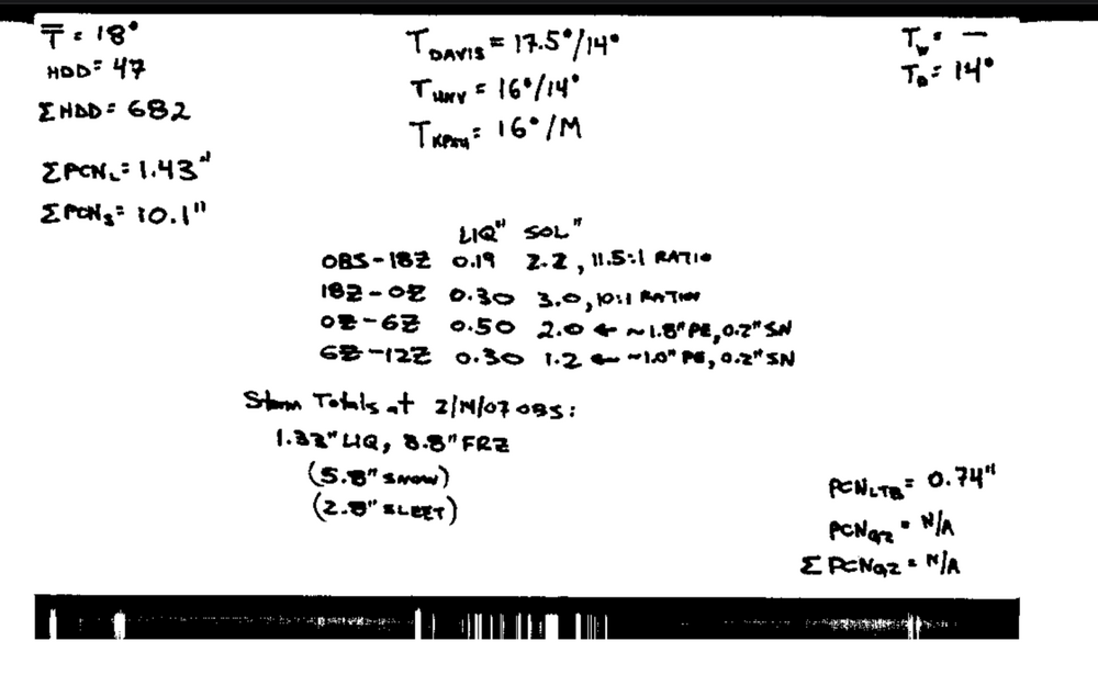
3 hours ago, Caveman said:
4.3" and done snowing...didn't melt the tube yet...Valley Green, Etters, PA
.19" liquid for an eye-popping 24:1 ratio
-
2
-
-
4.3" and done snowing...didn't melt the tube yet...Valley Green, Etters, PA
-
5
-
-
So much to think about...it's only a clipper...but the mid-level vorticity is potent...but the antecedent air mass was bone dry...but the height falls are impressive...but the surface high is too far south...but the low level winds are from the warm ocean advecting moisture...at the least, this will be an interesting winter event; if it were mild, we say we need this ~0.30 " of precip and go on our ways! Love the wx and the meteo!
-
1
-
-
It's a shame it would not come a bit sooner...especially to help decide is it better in winter conditions to have ships and sailors or tanks and militia...? Just sayin'...
-
10 minutes ago, Blizzard92 said:
About 1 inch of snow so far near Linglestown, but watching the warm nose push toward the Harrisburg metro.
1.2" here in Etters, but now a definite mix of liquid, ice pellets, and a few dendrites falling from the sky...
-
2 minutes ago, paweather said:
We haven’t had a good March winter for awhile
Not a fan of March winters as a former high school spring sports coach! Baseball in PIAA should be in the fall, but there's no way with king football. Track and field is ok...but often damp, cold and windy for both the runner and throwers! Love the 4 seasons!
-
1
-
 1
1
-
-
37 minutes ago, canderson said:
Wind reports
Location                     Speed     Time/Date       Provider

...Pennsylvania...

...Adams County...
Cashtown 1 S                 51 MPH    0700 AM 02/17   COOP

...Bedford County...
Bedford Airport              47 MPH    0515 AM 02/17   AWOS

...Blair County...
Altoona-Blair County Airport 59 MPH    0502 PM 02/16   AWOS
Blair Helibase               48 MPH    0116 AM 02/17   RAWS

...Cambria County...
Johnstown Airport            58 MPH    0420 PM 02/16   ASOS
1 E Cresson                  50 MPH    1125 PM 02/16   PADOT

...Centre County...
PSU Beaver Stadium WxSTEM    55 MPH    0620 PM 02/16   MESOWEST
University Park Airport      49 MPH    1053 AM 02/17   AWOS
PSU Golf Course WxSTEM       47 MPH    0610 PM 02/16   MESOWEST
1 NE Port Matilda            47 MPH    0625 PM 02/16   PADOT
Zion                         45 MPH    0638 PM 02/16   CWOP

...Clearfield County...
Clearfield Airport           51 MPH    0559 PM 02/16   ASOS

...Clinton County...
Lock Haven Airport           45 MPH    0645 PM 02/16   AWOS
Coffin Rock                  45 MPH    1016 AM 02/17   RAWS

...Cumberland County...
6 SSE Bloserville            47 MPH    0725 AM 02/17   PADOT

...Dauphin County...
ELIZABETHVILLE               63 MPH    0714 PM 02/16   CWOP
Harrisburg                   56 MPH    0400 PM 02/16   MESOWEST
Harrisburg Intl Airport      53 MPH    0601 PM 02/16   ASOS
Hummelstown                  48 MPH    0706 PM 02/16   CWOP
Reach Cyber CharSch WxSTEM   45 MPH    0720 PM 02/16   MESOWEST

...Franklin County...
1 NNW Marion                 49 MPH    0625 PM 02/16   PADOT

...Fulton County...
2 S Crystal Springs          54 MPH    0945 PM 02/16   PADOT

...Juniata County...
3 S Alfarata                 57 MPH    0650 PM 02/16   PADOT

...Lancaster County...
Lancaster Airport            58 MPH    0740 PM 02/16   ASOS
Lititz                       58 MPH    0824 PM 02/16   ASOS
Manheim                      55 MPH    0745 PM 02/16   CWOP
1 E Rothsville               52 MPH    0641 PM 02/16   Public
Elizabethtown                48 MPH    0836 PM 02/16   CWOP

...Lebanon County...
2 ENE Harper Tavern          58 MPH    0630 PM 02/16   Trained Spotter
Muir Airfield Ft. Indiantown 53 MPH    0917 AM 02/17   AWOS

...Lycoming County...
Williamsport Airport         55 MPH    0123 AM 02/17   ASOS

...McKean County...
Bradford Airport             53 MPH    0307 AM 02/17   ASOS

...Mifflin County...
Mifflin County Airport-RVL   64 MPH    0355 AM 02/17   AWOS
Lewistown                    53 MPH    0411 PM 02/16   Dept of Highways
Chestnut Springs             46 MPH    0451 PM 02/16   RAWS

...Perry County...
Newport                      49 MPH    0651 PM 02/16   Dept of Highways
2 ENE Newport                49 MPH    0725 PM 02/16   PADOT

...Schuylkill County...
Joe Zerbey Airport           51 MPH    0735 PM 02/16   AWOS

...Snyder County...
Selinsgrove                  48 MPH    1047 PM 02/16   ASOS

...Somerset County...
Somerset                     52 MPH    0600 PM 02/16   CWOP
Ogletown                     52 MPH    0610 PM 02/16   PADOT
Somerset Airport             48 MPH    0355 PM 02/16   AWOS

...Union County...
LEWISBURG                    46 MPH    0322 AM 02/17   CWOP

...York County...
Capitol City Airport         49 MPH    0916 AM 02/17   ASOS
York Airport                 47 MPH    0429 PM 02/16   ASOS
Dover                        47 MPH    0445 PM 02/16   CWOP
Thanks for sharing that PNS!
-
1
-


Central PA Winter 25/26 Discussion and Obs
in Upstate New York/Pennsylvania
Posted
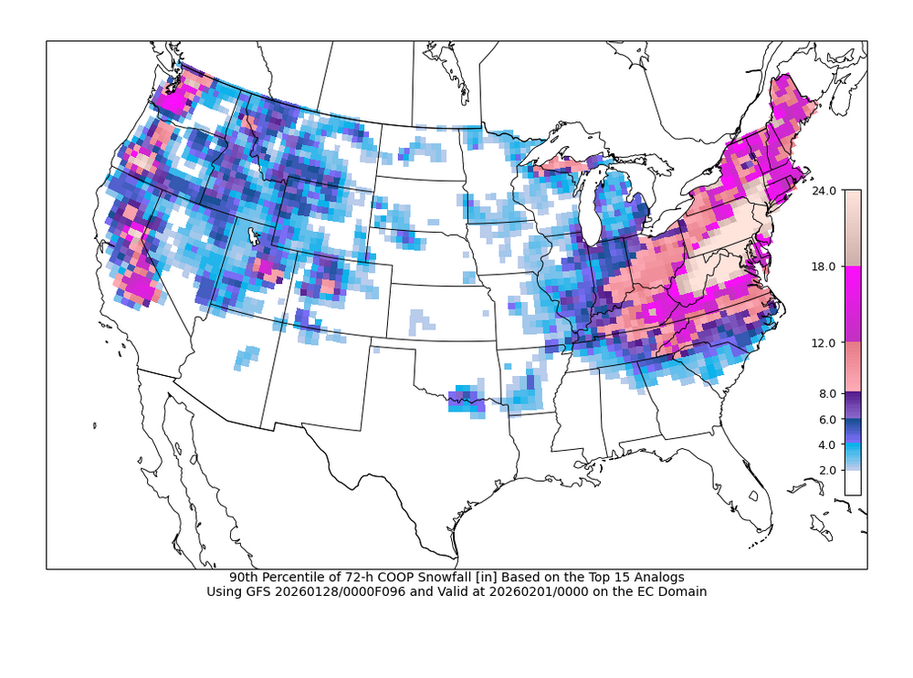
That is an excellent point concerning the skew of the 15 analog means by the 2 "outliers". It would be very interesting to be able to produce a map that does show the top 15 w/out the 2 "outliers"...but that is above my pay grade!