


colonel717
-
Posts
2,917 -
Joined
Content Type
Profiles
Blogs
Forums
American Weather
Media Demo
Store
Gallery
Everything posted by colonel717
-

Pittsburgh/Western PA WINTER ‘25/‘26
colonel717 replied to Burghblizz's topic in Upstate New York/Pennsylvania
-
Pittsburgh/Western PA WINTER ‘25/‘26
colonel717 replied to Burghblizz's topic in Upstate New York/Pennsylvania
Here is the current radar as compared to latest HRRR at this timeframe -
Pittsburgh/Western PA WINTER ‘25/‘26
colonel717 replied to Burghblizz's topic in Upstate New York/Pennsylvania
RDPS remains most bullish with combined squalls and clipper -
Pittsburgh/Western PA WINTER ‘25/‘26
colonel717 replied to Burghblizz's topic in Upstate New York/Pennsylvania
Looks like someone can pick up anywhere from an inch to 4 if they get in the right bands over next 2 days. Maybe slightly more in Cranberry and Butler Co.. 12z NAM suite is not as generous as the HRRR. A spotty inch or 2. -
Pittsburgh/Western PA WINTER ‘25/‘26
colonel717 replied to Burghblizz's topic in Upstate New York/Pennsylvania
Gonna be some nice squalls then Canadian likes the clipper. -
Pittsburgh/Western PA WINTER ‘25/‘26
colonel717 replied to Burghblizz's topic in Upstate New York/Pennsylvania
-
Pittsburgh/Western PA WINTER ‘25/‘26
colonel717 replied to Burghblizz's topic in Upstate New York/Pennsylvania
Looks like we could have a trackable clipper for New Year's then looks to be potential for a bigger storm from around 5th through 12th. -
Pittsburgh/Western PA WINTER ‘25/‘26
colonel717 replied to Burghblizz's topic in Upstate New York/Pennsylvania
Major storm bust for those in the east. WAA wins out again. NAM nailed the warm layers and most discounted it. Expected heavy snow but snow turned into sleet and freezing rain fest. -
Pittsburgh/Western PA WINTER ‘25/‘26
colonel717 replied to Burghblizz's topic in Upstate New York/Pennsylvania
Gotta wait until the cold front goes through on Monday hopefully kicking off some decent squalls again. Next week looks snow showery then something bigger could be in the mix around 5th thru 8th or so. EPS has pretty strong signal this far out. Something to track. -
Pittsburgh/Western PA WINTER ‘25/‘26
colonel717 replied to Burghblizz's topic in Upstate New York/Pennsylvania
https://x.com/WorldClimateSvc/status/2003594914958049366? -
Pittsburgh/Western PA WINTER ‘25/‘26
colonel717 replied to Burghblizz's topic in Upstate New York/Pennsylvania
-
Pittsburgh/Western PA WINTER ‘25/‘26
colonel717 replied to Burghblizz's topic in Upstate New York/Pennsylvania
Fri/Sat has trended much colder and now the NAM has us with severe icing. Still long ways to go for that s to play out, but something to watch. -
Pittsburgh/Western PA WINTER ‘25/‘26
colonel717 replied to Burghblizz's topic in Upstate New York/Pennsylvania
Looks like the area could see some brief snow moving in if it doesn't dry up as it gets here. -
Pittsburgh/Western PA WINTER ‘25/‘26
colonel717 replied to Burghblizz's topic in Upstate New York/Pennsylvania
Looks like this is back building again. I missed out most of the afternoon squalls. Hope these ramp up and head due east or go just south of me. -
Pittsburgh/Western PA WINTER ‘25/‘26
colonel717 replied to Burghblizz's topic in Upstate New York/Pennsylvania
Instead of crying about warm up, enjoy what we are getting today. After today models have been trying to pop a little brief snow on Tuesday. We see how horrible models can be more than a couple days out this year especially with borderline events. Maybe things trend south for some preChristmas snow. Then look to around 28th or so for next possible chance. -
Pittsburgh/Western PA WINTER ‘25/‘26
colonel717 replied to Burghblizz's topic in Upstate New York/Pennsylvania
SNOW SQUALL WARNING NWS PITTSBURGH PA 227 PM EST FRI DEC 19 2025 OHC029-PAC003-007-019-073-192015- /O.NEW.KPBZ.SQ.W.0018.251219T1927Z-251219T2015Z/ 227 PM EST FRI DEC 19 2025 Columbiana County OH-Allegheny County PA-Beaver County PA-Butler County PA-Lawrence County PA- The National Weather Service in Pittsburgh has issued a * Snow Squall Warning for... Northeastern Columbiana County in east central Ohio... Northern Allegheny County in southwestern Pennsylvania... Butler County in west central Pennsylvania... Beaver County in western Pennsylvania... Southern Lawrence County in western Pennsylvania... * Until 315 PM EST. * At 227 PM EST, a dangerous snow squall was located along a line from over East Palestine to over Coraopolis, or along a line from over East Palestine to near Franklin Park, moving east at 40 mph. HAZARD...Flash freeze on roads and rapidly falling visibility due to intense bursts of heavy snow and gusty winds. Wind gusts up to 35 mph. SOURCE...Radar indicated. IMPACT...Travel will become difficult and potentially dangerous within minutes. * Locations impacted include... Ross Township, McCandless Township, Cranberry, Moon Township, Butler, Franklin Park, Aliquippa, Beaver Falls, Columbiana, Monaca, East Palestine, Shaler Township, Hampton Township, New Kensington, Lower Burrell, Harrison Township, Economy, Ellwood City, Ambridge and Wexford. -
Pittsburgh/Western PA WINTER ‘25/‘26
colonel717 replied to Burghblizz's topic in Upstate New York/Pennsylvania
Looks to be another long band building that should approach North Hills and then your area in a little. You should see over an inch in your area. I have about 1/2 inch and best snows look north of me. -
Pittsburgh/Western PA WINTER ‘25/‘26
colonel717 replied to Burghblizz's topic in Upstate New York/Pennsylvania
Looks like north of city and esp. New Ken and north getting heavy snow. -
Pittsburgh/Western PA WINTER ‘25/‘26
colonel717 replied to Burghblizz's topic in Upstate New York/Pennsylvania
Looks heavy snow your way. Picked up about half inch so far. Back edge east of me just flurries now. HRRR says could seen snow until around 6pm. -
Pittsburgh/Western PA WINTER ‘25/‘26
colonel717 replied to Burghblizz's topic in Upstate New York/Pennsylvania
Maybe someone can pull in an inch or so. with the heavier returns to the west. -
Pittsburgh/Western PA WINTER ‘25/‘26
colonel717 replied to Burghblizz's topic in Upstate New York/Pennsylvania
Looks like radar filling in, Could be a snow showery day after losing all of our snow, -
Pittsburgh/Western PA WINTER ‘25/‘26
colonel717 replied to Burghblizz's topic in Upstate New York/Pennsylvania
Heavy winds and heavy snow out there just beautiful. Near whiteout. Too bad it is short lived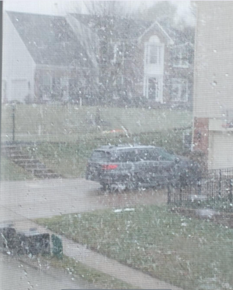
-
Pittsburgh/Western PA WINTER ‘25/‘26
colonel717 replied to Burghblizz's topic in Upstate New York/Pennsylvania
Was raining very heavily then quickly transitioned to heavy burst of snow. Precip lightened back to mix. -
Pittsburgh/Western PA WINTER ‘25/‘26
colonel717 replied to Burghblizz's topic in Upstate New York/Pennsylvania
From Ohio Valley Weather Center: [Tue 12/16/25 215pm EST] Today I will focus on the upper-level pattern at 500 mb (18000 feet). While there is some let up, focus on the 500 mb heights. Notice the tendency for higher heights to start building up into Alaska and slowly spreading into Greenland. Here is the caption for Friday morning. Notice the dive of colder air into the area, whereas just a handful of days ago, this was not shown. Models missed this. (Inage 1) Notice another piece coming in for Sunday into Monday. A lobe of cold comes through. Another instance where the model missed this a few days ago. Now, it seems to be sensing colder air. Again, higher heights into Alaska and NW Canada and up into Greenland, a bit. By no means, perfect, but modest enough to dump a batch of cold air in the region, again. (Image 2) So, assuming models will indeed miss Friday and catching on now, then missing another piece Sunday/Monday, it is hard to trust models past a handful of days. So, while it will not be as cold over the next week to ten days, if models are struggling in the medium range, there is no reason to trust models past 6 or 7 days. The tendency is for the model to keep the vortex stretched across Canada and central and eastern Russia, which implies colder air to spill into the central and east. I believe the models are mishandling things, and each subsequent run, the models slowly catch something and once inside 3 or 4 days, you see the change. -
Pittsburgh/Western PA WINTER ‘25/‘26
colonel717 replied to Burghblizz's topic in Upstate New York/Pennsylvania
All we can do over next few weeks is hope something pops up as models/ens don't have much in the way of snow opportunities. We still have some possible snow showers Friday after the front goes through that maybe can whiten us up briefly after the big melt down on Thursday/Friday. Also Canadian looks to try to pop a little something on the 22nd but fails. So something possibly to watch. Also, something I noticed this week. Looks like Tidbits is way ahead on Pivotal on getting the GFS run out. I always thought Pivotal was ahead of Tidbits on that.
