

HoarfrostHubb
-
Posts
58,468 -
Joined
-
Last visited
Content Type
Profiles
Blogs
Forums
American Weather
Media Demo
Store
Gallery
Everything posted by HoarfrostHubb
-
Should I start my grass seed?
-
Speaking of dustings… I had a minor one overnight or early morning.
-
 enjoy the scenery while we can. Back to brown lawns and sticks soon.
 -
Pigs gonna pig.
-
The leaves are getting that leathery look
-
Preliminarily ... a medium impact partial Miller B, Friday
HoarfrostHubb replied to Typhoon Tip's topic in New England
Mitch with 19”. -
Preliminarily ... a medium impact partial Miller B, Friday
HoarfrostHubb replied to Typhoon Tip's topic in New England
That’s awesome -
Preliminarily ... a medium impact partial Miller B, Friday
HoarfrostHubb replied to Typhoon Tip's topic in New England
Wachusett going with 6”. Seems right -
Preliminarily ... a medium impact partial Miller B, Friday
HoarfrostHubb replied to Typhoon Tip's topic in New England
3.25” Pembroke Ma (of course that’s rain…) -
Preliminarily ... a medium impact partial Miller B, Friday
HoarfrostHubb replied to Typhoon Tip's topic in New England
Plainfield MA 21”. -
Preliminarily ... a medium impact partial Miller B, Friday
HoarfrostHubb replied to Typhoon Tip's topic in New England
Okemo 23” -
Preliminarily ... a medium impact partial Miller B, Friday
HoarfrostHubb replied to Typhoon Tip's topic in New England
Crotched Mountain in NH without power -
Preliminarily ... a medium impact partial Miller B, Friday
HoarfrostHubb replied to Typhoon Tip's topic in New England
I read a tweet that on Mountain Road at 1400’ they measured 3” and a mile away at 1350’ they had zero. That was early in the day Parts of my town have grass showing -
Preliminarily ... a medium impact partial Miller B, Friday
HoarfrostHubb replied to Typhoon Tip's topic in New England
From a friend of mine in town -
Preliminarily ... a medium impact partial Miller B, Friday
HoarfrostHubb replied to Typhoon Tip's topic in New England
When I woke yesterday to straight rain I thought I was porked -
Preliminarily ... a medium impact partial Miller B, Friday
HoarfrostHubb replied to Typhoon Tip's topic in New England
Out the back it looks like a black and white world -
Preliminarily ... a medium impact partial Miller B, Friday
HoarfrostHubb replied to Typhoon Tip's topic in New England
Picked up another 3.25” since I snowblowed. 7.5” storm total. Really wet stuff.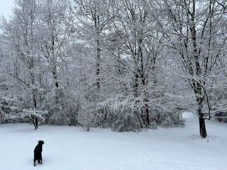
-
Preliminarily ... a medium impact partial Miller B, Friday
HoarfrostHubb replied to Typhoon Tip's topic in New England
11.0” in Ashby MA -
Preliminarily ... a medium impact partial Miller B, Friday
HoarfrostHubb replied to Typhoon Tip's topic in New England
Prob have picked up 0.75” since I went out earlier. Much drier stuff. -
Preliminarily ... a medium impact partial Miller B, Friday
HoarfrostHubb replied to Typhoon Tip's topic in New England
Always get a burger or a steak there. -
Preliminarily ... a medium impact partial Miller B, Friday
HoarfrostHubb replied to Typhoon Tip's topic in New England
Silver dollars in Hubbardston now -
Preliminarily ... a medium impact partial Miller B, Friday
HoarfrostHubb replied to Typhoon Tip's topic in New England
Someone on the other side of Hubbardston has 0.0”. Weird event -
Preliminarily ... a medium impact partial Miller B, Friday
HoarfrostHubb replied to Typhoon Tip's topic in New England
Too easy -
Preliminarily ... a medium impact partial Miller B, Friday
HoarfrostHubb replied to Typhoon Tip's topic in New England
Yep. Snoopy snow cone machine for parts. -
Preliminarily ... a medium impact partial Miller B, Friday
HoarfrostHubb replied to Typhoon Tip's topic in New England
It’s really waterlogged. If I had been home to wipe and clear a board maybe there would be a higher total Off to see if my old snowblower can tackle this shit


