

mahk_webstah
-
Posts
11,082 -
Joined
-
Last visited
Content Type
Profiles
Blogs
Forums
American Weather
Media Demo
Store
Gallery
Posts posted by mahk_webstah
-
-
I know it’s been more than 20 years for me. Until 2008 I was in Philly and my screen name was mark in Philly. I think it was 1995 or 96 when I started on that board. I have a memory of a guy named Gary Gray From the DC area and he used to make really long detailed posts and I remember his posts from the blizzard of 96.
-
 1
1
-
 1
1
-
-
New from WPC. One to 2 inch per band but fast moving
Farther north into Upstate NY and New England, much of the
precipitation is expected to fall as snow. The intensifying WAA
will result in a band of heavy snow as the resultant 850-700mb fgen
drives intense ascent into the DGZ just above. This will cause a
burst of snow lifting SW to NE Thursday, first in the Poconos, then
all points northeast, including New York City and Boston. Snowfall
rates within this burst could reach 1-2"/hr as reflected by the WPC
prototype snowband tool and HREF probabilities, but rapid
translation of this band northeast will somewhat limit total
accumulations. Still, substantial impacts are likely, and WPC
probabilities are high (>70%) for more than 4" of snow in the
higher terrain from the Adirondacks into the Greens and Whites,
with lesser accumulations likely in the lower elevations.
-
4 minutes ago, WinterWolf said:
Go back and look at the posts from the first page of this Feb thread….warmth was coming, and winter was dead from many posters.
SOUKD
some of us knew different
-
1
-
-
26 minutes ago, Prismshine Productions said:
Euro is still running on Pivotal so I don't have the 10:1 for the full run yet
Sent from my SM-S156V using Tapatalk
Your friend Kuchera is always welcome here!!!
-
35 minutes ago, TauntonBlizzard2013 said:
4-8” on superbowl Sunday would give a nice vibe
It would certainly help me manage my energy during the day. And then the storm should be over by the time the Super Bowl starts.
-
17 minutes ago, Damage In Tolland said:
America is on its way to being great again. This sally ness too will soon be gone
Having the cowboys suck year after year is helping!
-
1
-
-
7 minutes ago, DavisStraight said:
I was saying the same thing, no big dogs but a lot of puppies. At least we're tracking and snowing.
I suppose it depends on how you define big dogs but next week could bring a pretty big snowstorm
-
49 minutes ago, SACRUS said:
How much will fall in the frozen variety

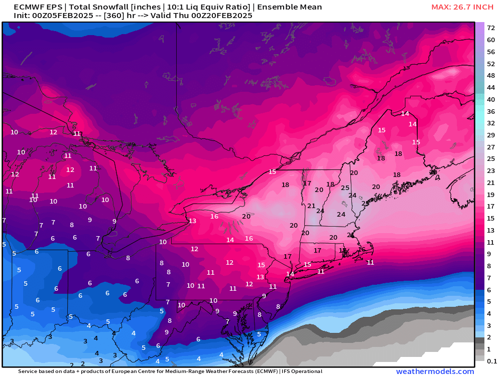
From NYC thread. This shows where we’re headed. Well over an inch for most of New England and the Wednesday storm isn’t finished yet. WPC tends to be a little conservative.
we are stepping into a fantastic few weeks of winter. We deserve it!
-
 1
1
-
-
47 minutes ago, LibertyBell said:
Many historic storms have occurred in a set up just like this
February 1983
January 1996
PD2 February 2003
January 2016
all our greatest hits....
The only one that seems similar to me is PD2. That was a week low with very strong over running with a jet that was five standard deviations I think. February 83 and January 1996 were Miller A
-
1
-
-
7 minutes ago, CoastalWx said:
The nice thing about that map is it even is good for the Cape. Nice E-W look there on the mean.
DC to QC
fredericksburg to Fredericton
Annapolis to Machias
region wide in a broad way
-
5 minutes ago, ORH_wxman said:
How can you say that without it posting a clown map for Moonshine? I will say the most impressive part of the EPS run is the 6” mean for BOS-ORH (and you can extend that basically down to HVN) for next week’s event (the event after Sunday which could be a prolonged overrunning situation)…impressive mean for that far out.
Don’t know that I’ve seen a mean like this up here. That is astounding. 24+
-
2
-
-
The euro has had a strong signal for days on this. My wunderground snow forecast has always been between five and 8 inches. Now it’s at 7.1. The Tuesday signal has jumped around wildly between two and 8 inches.
-
1 minute ago, Typhoon Tip said:
Having said that ... one of these events may over-achieve a little over this 10 days to two weeks. Yeah, sure ..
But some of these products look hefty for QPF given a pancaked compression of jet fields moving so fast for this guy
A miller B or Swfe redeveloper with nothing to slow it down is probably capped at 6-10 maybe lollies 12 I would think.
this isn’t supposed to be the season’s big storm. It’s supposed to be the first good region wide event with high-end advisories and low and warnings that opens the gate to a good stretch which probably will include one larger storm I would think or two.
-
A nice tidbit from GYX. When banding is mentioned it’s usually a good thing.
Guidance is in good agreement for the next system this weekend,
and have raised PoPs to go along with this. Thing to watch as
this event nears the mid to near term later is where banding may
develop to possibly enhance snowfall. For now the fgen band
appears to progress north, but if the storm takes a flatter
track, this may linger or pivot a bit longer. Overall, ensembles
show good confidence in another measurable snow event, but
amounts will need refinement over the coming days.
-
2
-
-
Just now, dendrite said:
SWFE so the DGZ is way up there. Most of the lift is below it.
That’s why, even though those really cold Swfe only produce 12:1 at best
-
1
-
-
3 minutes ago, Modfan2 said:
One thing that doesn’t appear to show in the long range is any deep cold weather
Good
-
2
-
2
-
-
Just now, dendrite said:
The couple of spots of not even a trace are cute.
Anyway…globals/rgem are pretty much 0.30-0.40 ish up here…nam and hrrr are meh. 3-4” looks good with a little ZL on top.
Well but maybe ratios are better for the 1st couple hours? Super cold at the start although I know ratios aren’t necessarily about the air temperature.
but 3” is a win
-
1
-
-
42 minutes ago, CAPE said:
This is the upper level pattern for early next week. Suppression is not the failure mode I would be worried about with this look. Imo it wont be easy to get an all snow event. Best shot very northern parts of the region.

Grabbed from MA forum. Alleviates suppression concern for early week. Who is gonna start the thread for what will be 3rd and most widespread event over a 6 day period?!
We are starting a great run.
-
2
-
-
3 minutes ago, dendrite said:
Euro still looks good. 3-6” and call it a day.
That would be a good outcome for here, especially given that Sunday might be a little beefier.
-
1
-
-
1 hour ago, Sey-Mour Snow said:
GEFS pretty amped for next Tuesday EPS has been too, starting to get that classic look
Just a matter of how far north the good stuff gets.
-
2 hours ago, Sey-Mour Snow said:
Big storm forming for Mid-Atlantic maybe SNE on 18z gfs next week .. DC to Philly crushed .. PD3 style big dog potential .. 10-20" DC to Philly .. 20-30" in around DC..
overrunner like PD2? How anomalous is the jet? That was a great storm in Philly
-
27 minutes ago, WinterWolf said:
No beer at all…I realize the thread, but the way the post was worded, I found it to be a little vague, and it almost sounded like they might have been referring to the threat after the 9th. So just wanted to make sure. Folks have posted comments in the wrong thread many times before…so I thought I’d ask.
It is the most perfect thread title ever. Perfect. Everyone knows and they’re saying there’s never been one as great as this one.
-
2
-
 3
3
-
2
-
-
2 minutes ago, dryslot said:
Could be a huge snow month.
I think we need to decide who’s gonna fire up the February 12-13 thread. A week out
-
2
-
-
1 minute ago, CoastalWx said:
Yeah you can see the rpimary in NY state, but then a siggy amount of members in redevelopment off LI.
Be nice if we get it to slow down. But that might be for next week
-
2
-
Feb 9: Iggles flying, weenies high-fivin’: the kickoff to a great stretch
in New England
Posted
What do you make of the ensembles of the European which show a lot of snow by Monday? Probably close to 10 inches just for you and maybe 13 or 14 for me?