

David Reimer
-
Posts
1,561 -
Joined
-
Last visited
Content Type
Profiles
Blogs
Forums
American Weather
Media Demo
Store
Gallery
Posts posted by David Reimer
-
-
-
39 minutes ago, the ghost of leroy said:
pilot guy pwning noobs ITT
Haha so someone does remember me from my very noobish days over on easternwx. That was a good 11-12 years ago now.
-
6 minutes ago, hickory said:
Wow I spelled corps wrong and suddenly I get attacked. Maybe it was typo did you ever think of that? Also to Mr. Reimer am I still not allowed to have a free opinion which is open to debate? If you disagree with me that is your right. Then prove me wrong. Dont just ban me or push me away.
I said best you take it to the OT sub-forum. You're more than welcome to have a debate about a hurricane from 13 years ago there.
-
26 minutes ago, hickory said:
Ban someone who is speaking there personal opinion in a free country. Sound like 1939 nazi Germany in here. I have not hurt anyone or posted anything graphic.
This isn't a free country. This is a private forum. Don't tell me you're one of those nutjobs who think they can post/do whatever they want on a forum or social media because 'its a free country?' Hate to tell you this... but as a private forum run by a group of individuals or a corporation, they are well within their right to remove your posting privileges simply because it is their prerogative. If you have feelings about a previous hurricane take it to the OT sub-forum.
-
 5
5
-
-
2 minutes ago, MattPetrulli said:
Don't understand why it's a 1 now despite the ever improving radar presentation
Anyhow, sounds bad on New Bern public safety scanner rescues in progress and structures down apparently.
Truthfully, they're being generous. It is more likely to have sustained winds of 80-85 MPH based on the SFMR data from this last recon flight. Despite a mid 950s MB pressure the wind field so broad/diffuse that there isn't enough of a gradient to get higher winds. The system certainly does have a higher gust component than some other canes we've tracked.
-
5
-
 1
1
-
-
We're not going to see wind speeds increase with the system so broad and so close to shore. Pressures may end up dropping some, but you'd need a significant pressure drop to have much increase in winds with such a large wind field. The only difference a strengthening system versus a weakening one at landfall is you'll be able to mix down FL winds more efficiently. With a dropsonde showing 956 MB we can also confirm there has been little change in pressures over the last several hours.
-
2
-
1
-
-
Inner core definitely looks better on IR than it did two hours ago. -79C towers on the west/southwest eyewall. As others have stated, we're unlikely to see a significant wind increase based on the expansive wind field along with the observed behavior fo the system today. Recon is going through the eye now and the pressures don't look to have changed.
-
-
Hurricane Harvey taught many observers in meteorology all the way up to long-time meteorologists that sometimes the craziest weather model solutions actually end up verifying. At some point, one has to start accepting the possibility that something almost unheard of/not really experienced before may actually happen. This is becoming one of those situations where something crazy is probably going to happen. When two different global models and their ensembles show a similar solution for several runs in a row you have to start considering that idea. I honestly can't believe we're having to deal with this just a year after Harvey. Just mindboggling...
Did South Carolina go through with their evacuation of the entire coastline? I certainly hope so - because the solution being depicted by the Euro ensembles would result in a significant coastal flood event for several hundred miles. You don't want to have a last-minute evacuation of several hundred thousand individuals.The next USAF recon flight should be departing from Savanah, GA in the next hour. We'll begin to have aircraft in the system for a majority of the day this afternoon as recon shifts to a 3-hour schedule (versus the 6-12 they've been on).
-
8
-
-
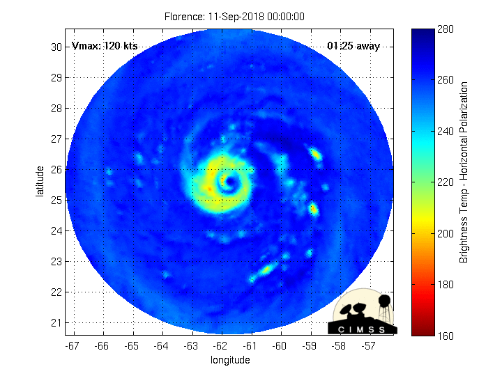
Looking at dropsonde data (versus the VDMs) it looks like the pressure may have gone up one to two millibars this evening. As others mentioned, winds are slowly increasing at both the surface and flight level. 130 knot FL wind in the NE quad on that last pass with SFMR around 125 MPH. It looks like we'll get at least one more pressure check from recon before they head home. I'd say Florence has spent most of the day recovering from the EWRC. Who knows if it'll stay steady-state or actually have some modest intensification. Either way, the wind field has expanded significantly today. Like Hurricane Ike and its massive wind field, the wheels have been set in motion for a potentially catastrophic storm surge - regardless of the eventual maximum wind speed.
-
3
-
-
I can see why they held it at 140 MPH. No need to make knee-jerk down/up revisions. They'll give it another few hours to see if winds start responding back up. If not, they can start reducing winds. Surface pressures are lowering. As I explained last night, the larger wind-field is helping keep the winds from responding upwards for now. As a 'rubber-band effect', the winds could respond upward quite quickly in the next 12-18 hours if the pressure keeps falling. We've seen it in several intense hurricanes after ERWC.
The wind being held at 140 MPH is probably being done for societal reasons versus pure scientific. The post-storm report will undoubtedly revise intensity estimates as needed.
-
3
-
1
-
-
Just now, irishbri74 said:
I believe it may have been a storm last year, where the inner eyewall held on a little longer and disrupted the core longer than expected.
just something to keep in mind when people expect a quick, clean ERC.
Indeed! Florence had a nice tower go up in the inner eyewall about 40 minutes ago. Last I saw it's still spinning around, but its something like that which can delay the removal of the inner eyewall. Recon won't be back in for several more hours, but I'd expect at least some weakening (lower winds/higher pressure). The key to intensification will be how quickly winds can respond back up once the pressure begins to fall. Undoubtedly the wind field has expanded considerably with this EWRC, so that'll probably keep winds in check for a time.
-
2
-
-
Just now, TheDreamTraveler said:
That will be a decent sized eye once the EWRC is complete. It seems to be making decent progress based off the GOES 16 rapid-scan data. Just need the remaining inner-eye to die off and then Florence will probably be off to the races. As I explained earlier, we may not see a potent increase in winds for a while (I'm assuming they've weakened), but I'd expect the pressure to start falling at a decent clip as that OEW starts contracting.
-
Honestly, it looks like the EWRC may already be well underway. It'll be critical to see how long it takes for the inner eye-wall to disintegrate, as that is when the outer can become dominant. Once that process completes expect a broadening of the wind field and probably a decent pressure drop. Winds may take a while to respond upward to any pressure drop with a broader wind field. It has been a 'rubber-band' effect in previous intense hurricanes. The pressure drops considerably, but winds don't increase for a while - until the 'rubberband' breaks and you see a rapid uptick in winds in the eyewall. (This explanation was for those of the general public who may have wandered onto this forum)
-
3
-
2
-
-
Well, that was a rather interesting last two hours in D/FW...
-
This evening's 0Z NAM, 3KMNAM, and GFS indicate the potential for a significant ice storm across parts of the Big Country, Northwest Texas, into portions of Oklahoma. I haven't looked farther north/east. I wouldn't be surprised to see some winter storm watches (prelude to any ice storm warnings) in the Tuesday morning packages.
-
4 minutes ago, cheese007 said:
Assuming you mean the southern portions corrext?
I'm getting pictures of accumulating sleet and light snow on cars and elevated objects in North Dallas and up in McKinney (380/75 area). Minor accumulations, but enough to keep roads wet. Wet roads with temperatures falling into the mid-20s in the next few hours could cause a flash-freeze (similar to what happened in BHM and ATL a few years back). That's my big worry for the next few hours. Anything that falls, even with surface temperatures below freezing, will probably melt as it hits surface roads and bridges. Soil temperatures are still around 40 degrees. That sleet/snow melts and makes the roads wet. Once surface temperatures fall to 25-26 degrees (or lower) those wet spots could easily flash-freeze into pure ice, especially on bridges and elevated roadways (which D/FW does not have a shortage of).
-
D/FW is going to have some really big problems if that sleet doesn't stop in the next hour. Lots of pictures coming in showing wet roads (since sleet/snow melting on contact). All that is going to flash-freeze once we get into the middle 20s, which is only 2-3 hours away.
-
The HRRRx (the HRRR experimental version) has done well in the past; so it is definitely worth watching as we get in operational range of the current HRRR. Remember that with surface temperatures falling into the 20s it won't take much precipitation to cause major travel problems. I'm also concerned with the potential for enhanced sleet bands across South-Central Texas. Some models have been hitting Austin and San Antonio pretty hard with sleet on Tuesday.
-
2
-
-
Irma has regained major hurricane status with maximum sustained winds of 115 MPH according to the National Hurricane Center. 2AM ET 9/21/17
-
I’m surprised that the NWS PR office has managed to stay up this whole time. Obviously they’re running on generator, but I figured they would have lost comms.
-
19 minutes ago, NJwx85 said:
We would like to thank the crew of the latest Air Force Reserve
mission for their incredible service today.  After beginning their
mission this morning before the center first moved onshore, the crew
went above and beyond, returning to Curacao to refuel, and then
heading back to Puerto Rico to catch Maria's center when it first
moved back off the coast.  The data collected by the crew was
incredibly important for us to analyze Maria's intensity and
structure after moving across the island, and we are grateful for
their effort.
Don’t think I’ve seen that happen before. Huge props to the flight crew for making that happen. Certainly adds to the paperwork for them and could have just as easily ended the flight early.
-
3
-
-
FWIW the OEW has shot off a few CGs over the last hour. As far as EWC goes Maria seems to be holding on fairly well. Not good for PR.
-
11 minutes ago, downeastnc said:
Pressure is up a few mb to 912 on that last pass and she looks a little less intense on the loop, some warming cloud tops especially on the north and west side....SW corner of St Croix in the moat but unless there is a nice north wobble should stay out of the inner eyewall...
Dropsonde was 912 MB with a splashdown of 22 knots - so still about 910 millibars. Latest vortex does report two eyewalls. A 10 NM and 18 NM. For a 'new' eye that 18 NM seems fairly small. TJUA showing the highest winds now with the outer (new) eyewall, so the ERC seems to be well underway.
MO/KS/AR/OK 2019-2020 Winter Wonderland Discussion
in Central/Western States
Posted