

David Reimer
-
Posts
1,561 -
Joined
-
Last visited
Content Type
Profiles
Blogs
Forums
American Weather
Media Demo
Store
Gallery
Posts posted by David Reimer
-
-
The southern jet originating from Mexico is going to add a few unknown variables into the coming days. Models handled extremely poorly with that element in events earlier this winter.
-
0Z guidance is also indicating the increasing potential for afternoon initiation in East Texas well east of the dryline in the open warm sector. FWIW those would likely pose a tornado threat given the favorable thermodynamics and kinematics. Unlike farther west, I don't see much VBV out that way during the afternoon. I'm interested to see the 06Z and 1730Z SWODY2. I wouldn't be too surprised if they went with a small MDT for hail at some point in the next day in North Texas/Southern Oklahoma (Texoma).
-
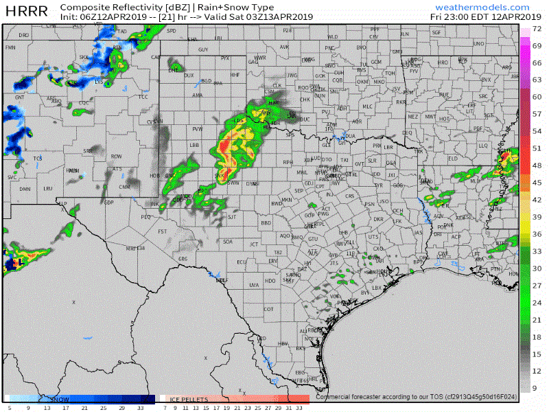
12Z TTU WRF has a very minor weakness around 800-825MB in North Texas at 22Z, and has it gone by the time a MONSTER supercell hits D/FW at 23-0Z. Something to watch closely as without that VBV there will likely a fairly substantial tornado risk with Wednesday's event in Texas. Either way, bowling-ball size hail with the afternoon storms and a decent high-wind event with the QLCS that night are good bets.

-
 4
4
-
 1
1
-
-
We'll see how Wednesday and Wednesday night involve in Texas, Oklahoma, east into the Arklatex. That VBV showing up at 0Z Thursday in the 0Z NAM is completely gone by 03Z. That VBV would result in a messy convective mode, but still, support a pretty significant hail threat with initial storms. Pretty good chance of a nasty QLCS into Thursday morning across Northeast Texas, East Texas, and Southeast Texas. We'll see just how much of a tornado threat can develop with that VBV.
-
-
Watch out for boundaries from those storms in East Texas into far western LA. Those could be big hotspots for pre-frontal convection by the late morning.
-
Just now, wotan said:
The real question is if they will go high risk at the first day 1 for Saturday. Imho, the risk to life and property should override the what ifs. There's enough there to warrant it. High risk captures the public's attention more than moderate. Again, imho.
Sent from my Pixel 3 XL using Tapatalk
The same was said on April 2, 2017 - and there was some pretty harsh backlash when that event didn't live up to the 'high risk' expectations. It's a tough line to walk between societal impacts and maintaining scientific/meteorological integrity.
-
2
-
-
0Z HREF/SREF-blended tornado probability guidance. It is more difficult to get higher probabilities, so the large 10% is actually pretty significant. As for my coverage area (Texas) it does seem we'll be dealing with a higher tornado risk compared to what I thought 24 hours ago.

-
6Z HRRR at the extended range has the warm front farther north by 15Z Saturday than the NAM. The result would be a significant severe weather threat for the D/FW Metroplex as a QLCS moves in from the west (hopefully just a big hail/wind threat with brief tornadoes). It fires up discrete storms *ahead* of that QLCS in eastern North Texas south into the Brazos Valley by 17-18Z in a volatile and dangerous environment. That solution would result in the threat of significant tornadoes beginning just east of Interstate 45 versus the 100-125 miles east that SPC has highlighted. The 0Z TTU WRF (Texas Tech WRF) does show a similar solution. Just throwing that out there as I hit the sack.
-
2
-
-
1 hour ago, canderson said:
I’m totally on mobile and shitty East Texas internet speeds but are the storms still going to come through Saturday morning? I think those end up playing a role in how quick the energy can kick out.
Late morning into the mid-afternoon hours. After 4 PM the LLJ should be veering in East Texas with the tornado threat lowering. Lousiana is all sorts of screwed at this point. Tonight's NAM would suggest a fairly potent tornado threat with storms from the late morning through mid-afternoon in East Texas.
-
1
-
-
The high risk 'bust' of 2017 is flashing in my mind in regards to Saturday. Conditions certainly do set up to support a significant severe weather event, but I'm not sure which mode will be dominant. A QLCS would result in plenty of damaging winds, hail, and brief tornadoes while a semi-discrete supercellular mode would probably have a substantial tornado threat. Lousiana is pretty much doomed at this point since timing is set up to support both modes out that way. I'm just not sure we'll get it done in East Texas before we veer or have VBV issues. Hopefully, we get more answers than questions with the 0Z model suite. We'll also have to see how far west the threat sets up on Saturday considering the slowing trend in data over the last day.
-
1
-
-
4 hours ago, 1900hurricane said:
Might consider a local chase today.
https://twitter.com/1900hurricane/status/1114568005915152384
Based off your tornado report I'm going to assume you did indeed go chasing

-
1
-
-
It's always nice when I can 'chase' severe weather from my porch. Had three separate rounds of hail today. First was this morning, the second was this evening, and the third (and largest) was about five minutes after the second. Ended up getting quarters and a half-dollar or two with the third round.
-
Low trust level with those storms impacting D/FW later this morning and Northeast Texas a bit after that. Latest HRRR runs along with the 0Z 3KMNAM both had tornado soundings galore with strong convection. Hopefully, it'll remain elevated, but even that will cause some hail issues given the impressive lapse rates and instability aloft.
-
Have some minor ice accumulations on elevated objects like trees and light posts. Looks like the heavier rain rates earlier this afternoon helped prevent more in the way of ice accumulation. We did have sleet for a while, but the rain just washed it away. It's harder to get ice accumulation this late in the season without temperatures in the 20s during the day. I'm curious if the OKC metro will see any bridge icing tonight with the freezing drizzle.
-
I wouldn't mind a switchover to sleet and snow in OUN at this point. This FZRA garbage needs to stop. We're starting to lose trees and I really don't want to flirt with power outages. It's all fun and pretty until the power goes out
-
Hope Y'all up in Tulsa get some good snow out of this! Looks like we're pretty locked in here in OUN (famous last words), so it would only be fitting for TSA to get some love too.
-
1
-
-
31 minutes ago, garfan said:
KFOR-TV is now stating a Winter Storm Warning is in effect for portions of cenntral and southern Oklahoma.
It's being discussed internally (NWSChat), but we'll see what actually comes out with the afternoon package.
-
Digging into the 0Z NAM shows a potentially nasty situation across Central Oklahoma on Thursday. It does have temperatures hovering near freezing, but if those were one to two degrees too warm, somebody would be getting a nasty ice event. FWIW the 0Z HRRR out to 12Z Thursday is even slower than the NAM with the upper-level low.
-
1
-
-
What a let down after 0Z guidance last night for Central Oklahoma. Another big bust.
-
1
-
-
After the early December model clusterbomb, I certainly understand offices being skeptical. Assuming deterministic models and their ensembles come into decent agreement tonight I'd expect various winter weather products to be issued by the midnight crews. Texas/Oklahoma offices have been great with the collaboration conferences this year, so whatever eventually gets issued will be done in a regional fashion with the morning forecasts.
-
1
-
-
2 hours ago, StormChazer said:
When should we start talking seriously about snow chances on Thurs/Fri? Gfs and nam seem to think this thing can drop a decent amount of snow somewhere in OK.
I'll probably hit the wind threat in my forecasts tomorrow with a low-chance of a rain/snow mix as precipitation ends from west to east across Central/Eastern OK into Texoma. I won't even mention accumulations (if at all) until Wednesday at the earliest. A cold core upper low is a weatherman's woe - and usually, do produce big surprises in the winter precipitation department. Combined with the anticipated wind, it wouldn't take much snow to create 'official' blizzard conditions in a few spots.
-
1
-
-
06Z NAM gives OKC 1.8"-2" of liquid QPF between 15Z Saturday and 03Z Sunday. That would be an insane amount of sleet and/or snow. FWIW the NAM decided to give OKC 26" of snow this run. It has the backside snow dropping 1-2" an hour snowfall well into the evening.

-
0Z NAM was a bit warmer for Central Oklahoma. That would keep the heaviest ice on the northern side of I-44 corridor (a 20-30 mile shift north). It also drops an insane amount of snow on the back of the slow. FWIW: It gives Shamrock, Texas almost 30" of snow. At least a foot across most of Oklahoma (north of the freeze line). Let's see what the 06Z HRRR going out to 6 AM Friday has for surface temperatures. 0Z GFS was a good sign for snow lovers. I'm glad y'all up in SW MO are going to get some (based off this run).
-
1
-
Severe storms and flash flooding for May 7-13
in Central/Western States
Posted