

David Reimer
-
Posts
1,561 -
Joined
-
Last visited
Content Type
Profiles
Blogs
Forums
American Weather
Media Demo
Store
Gallery
Posts posted by David Reimer
-
-
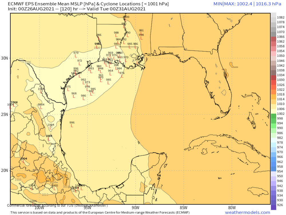
It would appear the 0Z Euro deterministic is on the eastern edge of its ensembles. Plenty take it into LA, but not as much of a shift east as I expected. Still going to have to keep an eye on the Upper Texas Coast.

-
The morning ensembles from the European and GFS (EPS & GEFS) still show a wide window of possibilities, generally focused on northern Mexico to the Upper Texas Coast. It would appear the 12Z ECMWF was a distinct northern outlier, while the 18Z GFS is 'centered' off the ensembles. I'm not touching the intensity forecast yet, but as others have said, a large on-shore wind field suggests a considerable heavy rain threat well inland and the potential for a prolonged surge event. Of-course, that's all just heresy based on weather model voodoo. Let us see where trends proceed over the next couple of days.
-
Inbound recon is finding FL winds up to around 45 knots (a bit higher perhaps, but suspect). I think it is safe to say Grace has regained tropical storm intensity.
-
Just now, JasonOH said:
That radar is far enough away for it to not be too useful. Based on BMX, the tornado likely never handed off.
Guess we'll see what the survey data shows. BMX did show a jump to the east between 22:39Z and 22:41Z. It doesn't really matter anyway.
-
3 minutes ago, JasonOH said:
I don’t think it has. It’s the same circulation. It’s just extremely close to the radar.
Go load a loop up from MXX. You can see the circulations hand off just west of I-65.
-
Tornado just handed off to a new circulation. New significant tornado in progress about a mile east of the old one.
-
Just now, CryHavoc said:
I know it's not recommended to talk about ratings on this site, but I would be absolutely stunned if that was less than an absolutely maxed out EF4, or worse.
I didn't have radarscope in 2011 for my phone, but I've been seeing colors/signatures I've never seen on that app before.
Feels like a historic tornado on the ground at the moment.The tornado, at some point in its life cycle, was capable of producing EF5 damage. I have absolutely no doubt about that. However, did the tornado hit anything capable of being rated EF-5 while the tornado was at its most violent? Who knows.
-
 5
5
-
-
I see the hype train is full speed ahead this afternoon. There remain a few ways Thursday's tornado threat could be dampened. Widespread warm sector precipitation thanks to the lack of a stronger EML, a mixed convective mode, etc. Let's see what the 12Z guidance looks like before we all start screaming 'DAY TWO HIGH RISK LIKELY! OMGGGGGGGGGGGG'. Heck, let's see what this evening's 0Z guidance shows. If the Euro, GFS, the HREF, and each of their respective ensemble majorities end up converging on an 'outbreak' solution? Sure, I could see a high risk showing up by Thursday. Does it really matter? No.
-
1
-
 1
1
-
-
18 hours ago, yoda said:
Jeff disagrees strongly
https://mobile.twitter.com/VORTEXJeff/status/1372373456629731330
Yesterday was certainly a significant event, but I personally don't believe it warranted a high risk in hindsight. Of course, hindsight is 20/20. Let's see how the post-analyzed probability maps look after the storm surveys are done and the maps are updated. A good 'moderate risk' event for sure IMO. Just like 4/15/11 could have gone with a high, yesterday probably should have stayed moderate. Perhaps I'm used to the 'high risks' of the 2000s and early 2010s.
All of that being said - I do hope yesterday doesn't become a prelude to a far more impactful event in a few weeks (2011 feels?).-
1
-
-
1 minute ago, Wmsptwx said:
Is billingsley storm on the ground?
Nope. BMX cancelled the tornado warning. Back down to ZERO TOR warnings in a high risk for tornadoes...

-
20 hours ago, David Reimer said:
[sarcasm]Since when has SPC 'played it smart' over the last few years?
 [/sarcasm]
I do agree with you though. Seems like most of the CAMs are showing a few ways the event could be limited (in the scope of a full-on outbreak). If anything, the last few HRRR runs seem to start the show in Central Alabama by 20Z with discrete storms in a loaded-gun environment. We'll have to see how the late night storms behave (whether its linear garbage or linear mischief).Perhaps I wasn't being sarcastic after all. One of those failure modes came to fruition this evening. There were certainly several tornadoes this afternoon in portions of Mississippi and Alabama. A few of them were significant (EF2+). Was today a 'high risk caliper event'? I'm leaning towards no. I don't fault the 06Z forecaster as their small high risk was placed alright. The 45% tornado late this morning and the continuation of the high risk at 01Z? You've got to be freaking kidding me. There's a rain shield with a few lightning strikes blasting across that 01Z high risk. There aren't even any severe storms in the rain shield! I'm afraid today will add a 'crying wolf' syndrome to some residents in those regions. They sure haven't forgotten April 27, 2011 - but we're coming up on the ten year anniversary. Today's tornado probabilities were identical to those on April 27, 2011. I don't expect every high risk to be a generational outbreak, but I sure do expect more than what we got today. One long-track tornado does not verify a 'high risk'. One EF2+ tornado does not verify a high risk (although I bet we do see at least two from this afternoon's activity).
-
4
-
-
24 minutes ago, Wmsptwx said:
Seems like there’s a ton of things working against this thing, thinking we see them play it smart and go moderate.
[sarcasm]Since when has SPC 'played it smart' over the last few years?
[/sarcasm]
I do agree with you though. Seems like most of the CAMs are showing a few ways the event could be limited (in the scope of a full-on outbreak). If anything, the last few HRRR runs seem to start the show in Central Alabama by 20Z with discrete storms in a loaded-gun environment. We'll have to see how the late night storms behave (whether its linear garbage or linear mischief). -
Product: NOAA Vortex Message (URNT12 KWBC)
Transmitted: 5th day of the month at 23:17Z
Agency: National Oceanic and Atmospheric Administration (NOAA)
Aircraft: Lockheed WP-3D Orion (Reg. Num. N43RF)
Storm Number & Year: 26 in 2020
Storm Name: Delta (flight in the North Atlantic basin)
Mission Number: 1
Observation Number: 24A. Time of Center Fix: 5th day of the month at 22:53:41Z
B. Center Fix Coordinates: 16.41N 79.50W
B. Center Fix Location: 210 statute miles (337 km) to the WSW (238°) from Kingston, Jamaica.
C. Minimum Height at Standard Level: 2,950m (9,678ft) at 700mb
D. Minimum Sea Level Pressure: 981mb (28.97 inHg)
E. Dropsonde Surface Wind at Center: From 130° at 15kts (From the SE at 17mph)
F. Eye Character: Closed
G. Eye Shape: Elliptical (oval shaped)
G. Orientation of Major Axis in Elliptical Eye: 90° to 270° (E to W)
G. Length of Major Axis in Elliptical Eye: 17 nautical miles (20 statute miles)
G. Length of Minor Axis in Elliptical Eye: 11 nautical miles (13 statute miles)
H. Estimated (by SFMR or visually) Maximum Surface Wind Inbound: 58kts (66.7mph)
I. Location & Time of the Estimated Maximum Surface Wind Inbound: 6 nautical miles to the SSE (161°) of center fix at 22:52:13Z
J. Maximum Flight Level Wind Inbound: From 253° at 59kts (From the WSW at 67.9mph)
K. Location & Time of the Maximum Flight Level Wind Inbound: 8 nautical miles to the SSE (159°) of center fix at 22:51:43Z
L. Estimated (by SFMR or visually) Maximum Surface Wind Outbound: 61kts (70.2mph)
M. Location & Time of the Estimated Maximum Surface Wind Outbound: 9 nautical miles to the NW (320°) of center fix at 22:57:38Z
N. Maximum Flight Level Wind Outbound: From 55° at 68kts (From the NE at 78.3mph)
O. Location & Time of the Maximum Flight Level Wind Outbound: 11 nautical miles (13 statute miles) to the NW (319°) of center fix at 22:58:09Z
P. Maximum Flight Level Temp & Pressure Altitude Outside Eye: 11°C (52°F) at a pressure alt. of 3,062m (10,046ft)
Q. Maximum Flight Level Temp & Pressure Altitude Inside Eye: 17°C (63°F) at a pressure alt. of 3,053m (10,016ft)
R. Dewpoint Temp & Sea Surface Temp: Not Available
S. Fix Determined By: Penetration, Radar, Wind, Pressure and Temperature
S. Fix Level: 700mb
T. Navigational Fix Accuracy: 0.01 nautical miles
T. Meteorological Accuracy: 0.5 nautical milesRemarks Section:
Maximum Flight Level Wind: 68kts (~ 78.3mph) which was observed 11 nautical miles (13 statute miles) to the NW (319°) from the flight level center at 22:58:09Z
-
21 minutes ago, wizard021 said:
I said 985 I was close. But hey what do I know .
1 hour ago, wizard021 said:Quickly intensifying now looks to me.
44 minutes ago, wizard021 said:Please tell me not to be rude what I am missing.
How do you not have a weenie tag?
anyway, dropsonde measured 999 MB with a 64 knot splashdown wind. Probably enough to upgrade to 65 knot cane with pressure is the low 990s. (1 MB reduction per 10 knots).
-
1
-
-
I'm hoping a boundary from Wednesday's convection will stick around and help the eastern TX Panhandle become a magical 'sweet spot' later today. For sure there will be chaser hoards galore up in Southwest Kansas - and I'll probably be among them unless the Panhandle target becomes more tempting. 00Z TTU WRF does have boundary magic on the TX/OK border, but certainly a conditional threat ATM. It would sure be nice to only have a three hour drive versus a five or six hour journey to the target area.
-
1 hour ago, jojo762 said:
Literally our first or second true dryline day of spring coming up in 48 hours and nobody is talking about it on here... amazing. Wx Twitter seems thoroughly convinced that Wednesday is garbage, I however am certainly not.
Global models continue to indicate a particularly interesting day across OK and KS, NAM is out to lunch imo, at least to an extent... You’ll see the NAM off by 200 miles wrt warm front location before you see the Euro off by that much... several critical things to watch tomorrow, 1. 00z RAOB 850mb temps in SW TX (how strong is the cap going to be along the dryline?), 2. Temperatures/dewpoints tomorrow in SW OK... NAM says mid/upper 40s dewpoints in SW OK, other models say 60s dewpoints.
Meh. It's 2020 and that itself is a kiss of death for multiple reason. I just had to walk in a sweater and pants in Norman... 48 hours before a potential chase. If it can bust it'll find a way. My 'chasecation' starts Wednesday too. That being said, I'm much more 'in love' with these setups versus the synoptically-evident events. More fun to chase, slower storm motions, and hopefully a few less idiots out and about. Hopefully a fun Texas Panhandle chase will be in order on Wednesday. I'll take this cooler weather over mid 70 degree dewpoints and a ridge. Northwest Texas does seem to be a hot spot this month.
-
3
-
-
16 minutes ago, Quincy said:
The environment from southern AL into southern GA rapidly becomes very favorable for tornadoes in the morning. If early convection can latch onto the warm front and ingest surface-based parcels, it could get ugly in a hurry. Storm motions suggest that storms could ride along the front right to the GA coast.
Time sensitive:
You getting trolled out to Dixie tomorrow or did you get your fill last weekend?
-
The 0Z HREF goes bonkers tomorrow. Note that this is the SREF-calibrated TOR probabilities, not the SIG-TOR one that tends to run hotter.

-
2
-
-
Punched the RFD from south to north of the Lawrence tornado as it crossed 59. That thing was certainly mean. I managed to get a visit from the ghost train before backing out and heading south to the Wichita storms. HP storms in major metropolitan areas (plus all the stupid trees) make Northeast Kansas a PITA to chase in.
-
1
-
-
Core aloft with the storm approaching Binger has been coming down a bit over the last ten minutes. The Fort Cobb mesonet, about 8 miles south of the storm, has north winds. I don't believe the storm is entirely surface-based. It is after 1 AM here after all. Of course, I thought the same thing early Tuesday morning and ended up with a tornado four miles to my northeast, so we'll see.
EDIT: aaaaaaaaaaaaaaaaaaaand OUN just added the 'TOR Possible' tag back again. See? I'm on a roll this week.

-
KJRH Tulsa has the Vinita tornado on their towercam.
-
The HREF is being aggressive with the tornado probabilities for this afternoon and evening (May 23, 2019). I haven't had a chance to dig into the actual model data yet, but I am still worried about a messy convective evolution with some VBV showing up.

-
OUN's afternoon AFD. It is worth noting they did add a SLGT for their CWA around 9 PM in conjunction with SPC. Their HWO is strongly worded as well.
"
A very subtle mid level vort max, strong mid level WAA, and weak
divergence aloft near the left exit region of a weak upper jet may
produce enough lift for widely scattered moist convection to
develop late in the day. Given persistent QPF signal within the
described zone, and increasingly unstable conditions expected
during the afternoon/early evening, confidence was high enough to
include low chance PoPs near I-35. However, height rises and very
little low level forcing may limit the overall coverage. If
storms do manage to develop, the environment will be favorable for
supercells and this will include a conditional threat of strong
tornadoes."
-
1
-
-
Don't be surprised if we have a few more tornadic supercells pop up in far East Texas in the coming hours.
-
1
-
Major Hurricane Ida
in Tropical Headquarters
Posted
I saw FL winds of 76 knots, but I'm a little weary of the SFMR data given the closer proximity to Cuba's shoreline. That being said, if it isn't there now - it probably will be sooner than later. It's a hurricane regardless.