

CarlislePaWx
-
Posts
2,541 -
Joined
-
Last visited
Content Type
Profiles
Blogs
Forums
American Weather
Media Demo
Store
Gallery
Posts posted by CarlislePaWx
-
-
At 3:11pm I have just hit my high of the day so far at 95.0 degrees. My dew point is 76.8 degrees producing a heat index of 110! Easily in excessive heat warning territory. I can't wait for early next week when we go back to below normal with low 80's and lows in the 50's!
-
 1
1
-
-
UGHH! With the hazy sun shining for quite a while now, the temperature has reached 92.8 degrees. Couple that with a dew point of 78.4 degrees and you get a heat index of 109 degrees...worthy of an excessive heat warning.
-
57 minutes ago, TheClimateChanger said:
One of only two years (out of 136) at Harrisburg, where the minimum temperature has not dropped below 65F.
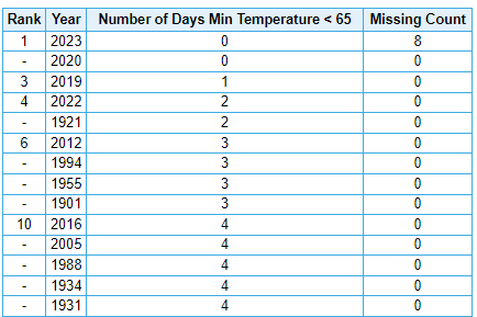
Take a look at the top 5...incredibly it's every year since 2019!

-
Station lightning strike count just hit 1500. Very prolific. It can detect strikes in a diameter out to about 27 miles.
-
Looks like I've escaped the severe weather. Winds preceded the heavy rain, but my station's max gust has been 9 mph...lol. (not the best exposure for wind). Frequent lightning and thunder. Approaching a 1/2" of rainfall in under 15 minutes. Also, wonderful temperature drop from 77 to 65! I thought I briefly heard a little bit of hail, but I did not see anything, just heard pinging off my metal patio chairs.
-
The drama is closing in quickly. All of Cumberland county is under a severe thunderstorm warning for the potential of tornadoes, large hail nearing 1" diameter, 60 mph wind gusts, and torrential rain with flash flooding possible. It's about 7 miles west of me, moving east at 25 mph. That puts the leading edge over me in about 10 minutes (around 1:00am). It's still 77 degrees here and has been 77 for nearly the entire evening. Dew point back up again, now 71 degrees. My lightning detector is showing over 500 strikes since the storms were within 25 miles of me, an increasing quickly. I expect to begin hearing thunder very soon.
-
0.71" here in the last 90 minutes. Diminishing now, just light to moderate. 68.0 degrees. MTD rainfall = 3.19" ; YTD = 19.03". Rapidly closing the big precip gap, down to less than 3" deficit to date.
-
High temp today here was 91.9. High here yesterday was 93.2. High on the 5th was also 93.2 while the high on the 4th was 90.0. That's 4 in a row for me. I'll have to go and check but I must be getting close to 10 days exceeding 90 this year.
Was treated to a pop up storm with heavy rain about 2 hours ago that quickly deposited 0.51". For the first 7 days of this month my precip total is 2.48". All grass is solid green again. YTD precip total up to 18.32", which is roughly about 3" below normal. That's a 50% reduction in the YTD deficit from only a week ago.
-
3
-
-
Highest dew point of the year right now with temp of 83.5 and dew point of 73 with a heat index of 90. Yesterday's dew point maxed out at 72 right after the rain shower hit around 4:00 and quickly dumped 0.16" of rain.
-
I guess I've been on the luckier side for precip totals. Thursday = 0.15"; Friday = 0.64"; Saturday (today so far) = 0.66" for a 3-day total of 1.55". My brown grass has rapidly greened up. My high yesterday was only 62.6 with a low of 56.2. The high temp was nearly 20 degrees below normal for the date. Today it has warmed up to 67.3 for the current high. Right now it's just overcast with no rain falling. Meso charts aren't showing too much more going out to Monday with only an additional 0.3". We'll see about that.
-
1
-
-
8 minutes ago, Itstrainingtime said:
That 2016 storm - the NAM was showing this "outrageous" stripe of 40" snows along the I81 corridor 48 hours in advance. It nailed that storm. No other model was honing in on that intense stripe of snow, especially that far out.
That part I remember well. I don't think any of us had ever seen that much forecast ever over us. Certainly there was the usual "throw it out", but NAM was king for that one.
-
2
-
-
1 minute ago, Bubbler86 said:
The January 2016 United States blizzard produced up to 3 ft (91 cm) of snow in parts of the Mid-Atlantic and Northeastern United States during January 22–24, 2016. A weather system, evolving from a shortwave trough that formed in the Pacific Northwest on January 19, consolidated into a defined low-pressure area on January 21 over Texas. Meteorologists indicated that a resultant storm could produce more than 2 ft (61 cm) of snow across a wide swath of the Mid-Atlantic region and could "paralyze the eastern third of the nation", and regarded it as a "potentially historic blizzard".[1][2] Winter weather expert Paul Kocin described the blizzard as "kind of a top-10 snowstorm".[3]
Wow...my apologies. I guess this is what happens when you are in 60s...lol
-
 4
4
-
-
2 minutes ago, sauss06 said:
January 22-23rd 33"
Do I have the date wrong? Jan 23rd was the following Saturday. Hmmm. I'm sure someone here can verify this.
-
5 minutes ago, Jns2183 said:
Didn't we get out biggest snowstorm in history from the last super el nino?
Sent from my SM-G970U using Tapatalk
Saturday, January 16, 2016 I received 35" of snow making it the biggest single snowstorm accumulation of my life. (I was 57 at the time). I think temps were mainly in the low 20s, but I can't remember that as well.
-
Skies are much bluer this morning, finally. I know the smoke might return, but hopefully not for a while.
It's 77 degrees now with a dewpoint of 50. Still dry! Picked up 0.06" late yesterday afternoon, but it didn't last long. Low this morning was 47.7...another low in the 40's. Month-to-date precip a plaltry 0.15". YTD 13.18". That's at least 5" below normal.
-
2
-
-
3 Hours ago my dewpoint was 47. I just looked at my station. Temp 75, RH 29%, dewpoint 36 !!! It dropped 11 degrees in 3 hours. Incredible.
My low this morning was a nippy 44.1 degrees. As for smoke in my area...it is just as the models show it. West of MDT the concentration drops off dramatically. Worst was yesterday midday. I could see the light haze all around and could smell it faintly. Will be interesting to see what happens over the next 24-36 hours. I think I haven't seen the dewpoint above 60 more than 3 or 4 times this entire season thus far. The low dewpoints in summertime I love. It gives us cool morning lows in the 50s. Like others have already stated here...dewpoints in the 30s in June are crazy!
-
Add me to the list of smoke smellers. Took the dog out about 45 minutes ago and immediately could smell it. Nothing intense, for sure, but noticeable. 2 years ago when we vacationed up in Alaska, our last day there in Fairbanks was like nothing I had ever seen before. This was not a surprise to locals as with relative frequency forest fires create a lot of smoke. It's enough to shut down motels and resorts. We woke up to it out our window. It had arrived overnight. It was like dense fog but with an odor. I'm curious to see how bad/dense it gets later tomorrow.
-
1
-
-
Before today, it was 14 days ago on May 20th I recorded 0.11" of rainfall.
-
The storm is going to miss to my south. Might even miss Mt. Holly. York Springs looks like a target unless is does a vanishing act. Hey, I picked up 0.09" of much needed rain. At least I got something.
I'm pretty sure I've never seen 3 consecutive severe thunderstorm warnings over only a 3-hour period. In every one of them Carlisle was on the edge of the box in different directions.
-
3 minutes ago, Jonesy56 said:
Not sure if this will work….
https://share.icloud.com/photos/096u1U5BpeSoSLGkhWRki9uiA
.Thanks! It worked!
-
4 minutes ago, anotherman said:
It’s going to miss us here. Damn it.
Unless it expands to its northwest, it's going to just miss me to the south, hitting Mt. Holly. But the purple on the radar is wild.
-
4 minutes ago, canderson said:
It’s hailing
Take pictures/videos of the hail!
-
3 minutes ago, canderson said:
It’s hailing
Unbelievable! Your storm now, but I got a little surprise action with a cell that rapidly formed right over me. Picked up a quick 0.09". I wonder if I will see any of your storm??
-
This storm is performing the great vanishing act. Talk abut rapid weakening. What's left of it is rapidly disappearing. Now I wouldn't be surprised if I get zippo out of it. The winds are beginning to rustle the trees as the sinking air approaches. It is getting a little darker.
Central PA Summer 2023
in Upstate New York/Pennsylvania
Posted
95.5 / 77.4 / 111 ! I think this is getting real close to the highest heat index I have ever witnessed / recorded.